NASA Terra Project
atmosphere carbon climate cog earth observation elevation hdf hydrology ice land cover netcdf oceans satellite imagery stac
Description
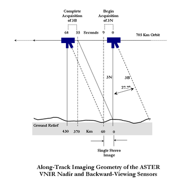
The AST14DEM Version 3 data product was decommissioned on December 15, 2025. Users are encouraged to use the AST14DEM Version 4 data product. The Terra Advanced Spaceborne Thermal Emission and Reflection Radiometer (ASTER) Digital Elevation Model (AST14DEM) product is generated using bands 3N (nadir-viewing) and 3B (backward-viewing) of an ASTER Level 1A image acquired by the Visible and Near Infrared (VNIR) sensor. The VNIR subsystem includes two independent telescope assemblies that facilitate the generation of stereoscopic data. The band 3 stereo pair is acquired in the spectral range of 0.78 and 0.86 microns with a base-to-height ratio of 0.6 and an intersection angle of 27.7 degrees. There is a time lag of approximately one minute between the acquisition of the nadir and backward images.For a better understanding, refer to the ASTER Along Track Imaging Geometry diagram depicting the along-track imaging geometry of the ASTER VNIR nadir and backward-viewing sensors. The accuracy of the new LP DAAC produced DEMs will meet or exceed accuracy specifications set for the ASTER relative DEMs by the Algorithm Theoretical Basis Document (ATBD). Users likely will find that the DEMs produced by the new LP DAAC system have accuracies approaching those specified in the ATBD for absolute DEMs. Validation testing has shown that DEMs produced by the new system frequently are more accurate than 25 meters root mean square error (RMSE) in xyz dimensions. The ASTER Digital Elevation Model data product is only available through NASA's Earthdata Search. The ASTER Order Instructions provide step-by-step directions for ordering this product. Known Issues: Data acquisition gaps: On November 28, 2024, one of Terra's power-transmitting shunt units failed. As a result, there was insufficient power to maintain functionality of the ASTER instrument. ASTER resumed acquisitions for the VNIR bands on January 18, 2025, and for the TIR bands on April 15, 2025. Users should note the data gap in ASTER acquisitions from November 28, 2024, through January 16, 2025, for VNIR observations, and a gap from November 28, 2024, through April 15, 2025, for TIR acquisitions. Improvements/Changes from Previous Versions * As of January 2021, the LP DAAC has implemented version 3.0 of the Sensor Information Laboratory Corporation ASTER DEM/Ortho (SILCAST) software, which is used to generate the Level 2 on-demand ASTER Orthorectified and Digital Elevation Model (DEM) products (AST14). The updated software provides digital elevation extraction and orthorectification from ASTER L1A input data without needing to enter ground control points or depending on external global DEMs at 30-arc-second resolution (GTOPO30). It utilizes the ephemeris and attitude data derived from both the ASTER instrument and the Terra spacecraft platform. The outputs are geoid height-corrected and waterbodies are automatically detected in this version. Users will notice differences between AST14DEM, AST14DMO, and AST14OTH products ordered before January 2021 (generated with SILCAST V1) and those generated with the updated version of the production software (version 3.0). Differences may include slight elevation changes over different surface types, including waterbodies. Differences have also been observed over cloudy portions of ASTER scenes. Additional information on SILCAST version 3.0 can be found on the SILCAST website. * Starting June 23, 2021, radiometric calibration coefficient Version 5 (RCC V5) will be applied to newly observed ASTER data and archived ASTER data products. Details regarding RCC V5 are described in the following journal article. * Tsuchida, S., Yamamoto, H., Kouyama, T., Obata, K., Sakuma, F., Tachikawa, T., Kamei, A., Arai, K., Czapla-Myers, J.S., Biggar, S.F., and Thome, K.J., 2020, Radiometric Degradation Curves for the ASTER VNIR Processing Using Vicarious and Lunar Calibrations: Remote Sensing, v. 12, no. 3, at https://doi.org/10.3390/rs12030427.
AST14DEM
The Terra Advanced Spaceborne Thermal Emission and Reflection Radiometer (ASTER) Digital Elevation Model (AST14DEM) product is generated using bands 3N (nadir-viewing) and 3B (backward-viewing) of an ASTER Level 1A image acquired by the Visible and Near Infrared (VNIR) sensor. The VNIR subsystem includes two independent telescope assemblies that facilitate the generation of stereoscopic data. The band 3 stereo pair is acquired in the spectral range of 0.78 and 0.86 microns with a base-to-height ratio of 0.6 and an intersection angle of 27.7 degrees. There is a time lag of approximately one minute between the acquisition of the nadir and backward images. For a better understanding, refer to the diagram depicting the along-track imaging geometry diagram of the ASTER VNIR nadir and backward-viewing sensors.ASTGTM_NUMNC
The Terra Advanced Spaceborne Thermal Emission and Reflection Radiometer (ASTER) Global Digital Elevation Model (GDEM) Version 3 (ASTGTM) provides a global digital elevation model (DEM) of land areas on Earth at a spatial resolution of 1 arc second (approximately 30 meter horizontal posting at the equator). The development of the ASTER GDEM data products is a collaborative effort between National Aeronautics and Space Administration (NASA) and Japan's Ministry of Economy, Trade, and Industry (METI). The ASTER GDEM data products are created by the Sensor Information Laboratory Corporation (SILC) in Tokyo. The ASTER GDEM Version 3 data product was created from the automated processing of the entire ASTER Level 1A archive of scenes acquired between March 1, 2000, and November 30, 2013. Stereo correlation was used to produce over one million individual scene based ASTER DEMs, to which cloud masking was applied. All cloud screened DEMs and non-cloud screened DEMs were stacked. Residual bad values and outliers were removed. In areas with limited data stacking, several existing reference DEMs were used to supplement ASTER data to correct for residual anomalies. Selected data were averaged to create final pixel values before partitioning the data into 1 degree latitude by 1 degree longitude tiles with a one pixel overlap. To correct elevation values of water body surfaces, the ASTER Global Water Bodies Database (ASTWBD) Version 1 data product was also generated. The geographic coverage of the ASTER GDEM extends from 83° North to 83° South. Each tile is distributed in both a Cloud Optimized GeoTIFF (COG) and NetCDF4 format through NASA Earthdata Search. Data are projected on the 1984 World Geodetic System (WGS84)/1996 Earth Gravitational Model (EGM96) geoid. Each of the 22,912 tiles in the collection contain at least 0.01% land area. Provided in the ASTER GDEM product are layers for DEM and number of scenes (NUM). The NUM layer indicates the number of scenes that were processed for each pixel and the source of the data. While the ASTER GDEM Version 3 data products offer substantial improvements over Version 2, users are advised that the products still may contain anomalies and artifacts that will reduce its usability for certain applications. Known Issues: ASTER GDEM Version 3 tiles overlap by one pixel to the north, south, east, and west of the tile perimeter. In most cases the overlapping edge pixels have identical pixel values, but it is possible that in some instances values will differ. * ASTER GDEM Version 3 is considered to be void free except for Greenland and Antarctica. * Users are reminded that because there are known inaccuracies and artifacts in the dataset, to use the product with awareness of these limitations. The data are provided "as is" and neither NASA nor METI/Earth Resources Satellite Data Analysis Center (ERSDAC) will be responsible for any damages resulting from use of the data.ASTWBD_ATTNC
The Terra Advanced Spaceborne Thermal Emission and Reflection Radiometer (ASTER) Global Water Bodies Database (ASTWBD) Version 1 data product provides global coverage of water bodies larger than 0.2 square kilometers at a spatial resolution of 1 arc second (approximately 30 meters) at the equator, along with associated elevation information. The ASTWBD data product was created in conjunction with the ASTER Global Digital Elevation Model (ASTER GDEM) Version 3 data product by the Sensor Information Laboratory Corporation (SILC) in Tokyo. The ASTER GDEM Version 3 data product was generated using ASTER Level 1A scenes acquired between March 1, 2000, and November 30, 2013. The ASTWBD data product was then generated to correct elevation values of water body surfaces. To generate the ASTWBD data product, water bodies were separated from land areas and then classified into three categories: ocean, river, or lake. Oceans and lakes have a flattened, constant elevation value. The effects of sea ice were manually removed from areas classified as oceans to better delineate ocean shorelines in high latitude areas. For lake water bodies, the elevation for each lake was calculated from the perimeter elevation data using the mosaic image that covers the entire area of the lake. Rivers presented a unique challenge given that their elevations gradually step down from upstream to downstream; therefore, visual inspection and other manual detection methods were required. The geographic coverage of the ASTWBD extends from 83°N to 83°S. Each tile is distributed in GeoTIFF format and referenced to the 1984 World Geodetic System (WGS84)/1996 Earth Gravitational Model (EGM96) geoid. Each data product is provided as a zipped file that contains an attribute file with the water body classification information and a DEM file, which provides elevation information in meters.AST_L1A
The AST_L1A Version 3 data product was decommissioned on December 15, 2025. Users are encouraged to use the AST_L1A Version 4 data product. The Advanced Spaceborne Thermal Emission and Reflection Radiometer (ASTER) Level 1A (AST_L1A) contains reconstructed, instrument digital numbers (DNs) derived from the acquired telemetry streams of the telescopes: Visible and Near Infrared (VNIR), Shortwave Infrared (SWIR), and Thermal Infrared (TIR). Additionally, geometric correction coefficients and radiometric calibration coefficients are calculated and appended to the metadata but not applied. The AST_L1A product has a spatial resolution of 15 meters (m) for the VNIR bands, 30 m for the SWIR bands, and 90 m for the TIR bands. Known Issues: Users are advised that ASTER SWIR data acquired from April 2008 to the present exhibit anomalous saturation of values and anomalous striping. This effect is also present for some prior acquisition periods. Please refer to the ASTER SWIR User Advisory for more details. * Data acquisition gaps: On November 28, 2024, one of Terra's power-transmitting shunt units failed. As a result, there was insufficient power to maintain functionality of the ASTER instrument. ASTER resumed acquisitions for the VNIR bands on January 18, 2025, and for the TIR bands on April 15, 2025. Users should note the data gap in ASTER acquisitions from November 28, 2024, through January 16, 2025, for VNIR observations, and a gap from November 28, 2024, through April 15, 2025, for TIR acquisitions. Improvements/Changes from Previous Version * Geometric correction to account for Earth's rotation angle and nutation. * Geometric correction for geolocation errors associated with nighttime TIR scenes. * Radiometric correction to account for degradation of onboard calibration lamps. * Starting June 23, 2021, radiometric calibration coefficient Version 5 (RCC V5) will be applied to newly observed ASTER data and archived ASTER data products. Details regarding RCC V5 are described in the following journal article. * Tsuchida, S., Yamamoto, H., Kouyama, T., Obata, K., Sakuma, F., Tachikawa, T., Kamei, A., Arai, K., Czapla-Myers, J.S., Biggar, S.F., and Thome, K.J., 2020, Radiometric Degradation Curves for the ASTER VNIR Processing Using Vicarious and Lunar Calibrations: Remote Sensing, v. 12, no. 3, at https://doi.org/10.3390/rs12030427.AST_L1A
The Advanced Spaceborne Thermal Emission and Reflection Radiometer (ASTER) Level 1A (AST_L1A) contains reconstructed, instrument digital numbers (DNs) derived from the acquired telemetry streams of the telescopes: Visible and Near Infrared (VNIR), Shortwave Infrared (SWIR), and Thermal Infrared (TIR). Additionally, geometric correction coefficients and radiometric calibration coefficients are calculated and appended to the metadata but not applied. The AST_L1A product has a spatial resolution of 15 meters (m) for the VNIR bands, 30 m for the SWIR bands, and 90 m for the TIR bands. Know Issues * The QAPERCENTINTERPOLATEDDATA field in .met files was found to be inconsistent due to a software upgrade. Following evaluation by the ASTER Science Team, it was determined to have no impact on science data and has been set to 0 and nullified. * SWIR data acquired after April 2008 may exhibit anomalous saturation and striping. Users should consult the ASTER SWIR User Advisory for additional details.AST_L1B
The AST_L1B Version 3 data product was decommissioned on December 15, 2025. Users are encouraged to use the AST_LB1 Version 4 of this product The Terra Advanced Spaceborne Thermal Emission and Reflection Radiometer (ASTER) Level 1B (AST_L1B) Registered Radiance at the Sensor data product is radiometrically calibrated and geometrically co-registered. Application of intra-telescope and inter-telescope registration corrections for all bands are relative to the reference band for each telescope: Visible and Near Infrared (VNIR) Band 2, Shortwave Infrared (SWIR) Band 6, and Thermal Infrared (TIR) Band 11. The AST_L1B product has a spatial resolution of 15 meters (m) for the VNIR bands, 30 m for the SWIR bands, and 90 m for the TIR bands. The ASTER L1B Registered Radiance at the Sensor data product is only available through NASA's Earthdata Search. The ASTER Order Instructions provide step-by-step directions for ordering this product. Known Issues: Users are advised that ASTER SWIR data acquired from April 2008 to the present exhibit anomalous saturation of values and anomalous striping. This effect is also present for some prior acquisition periods. Please refer to the ASTER SWIR User Advisory for more details. * Data acquisition gaps: On November 28, 2024, one of Terra's power-transmitting shunt units failed. As a result, there was insufficient power to maintain functionality of the ASTER instrument. ASTER resumed acquisitions for the VNIR bands on January 18, 2025, and for the TIR bands on April 15, 2025. Users should note the data gap in ASTER acquisitions from November 28, 2024, through January 16, 2025, for VNIR observations, and a gap from November 28, 2024, through April 15, 2025, for TIR acquisitions. Improvements/Changed from Previous Version * Starting June 23, 2021, radiometric calibration coefficient Version 5 (RCC V5) will be applied to newly observed ASTER data and archived ASTER data products. Details regarding RCC V5 are described in the following journal article. * Tsuchida, S., Yamamoto, H., Kouyama, T., Obata, K., Sakuma, F., Tachikawa, T., Kamei, A., Arai, K., Czapla-Myers, J.S., Biggar, S.F., and Thome, K.J., 2020, Radiometric Degradation Curves for the ASTER VNIR Processing Using Vicarious and Lunar Calibrations: Remote Sensing, v. 12, no. 3, at https://doi.org/10.3390/rs12030427.AST_L1B
The Terra Advanced Spaceborne Thermal Emission and Reflection Radiometer (ASTER) Level 1B (AST_L1B) Registered Radiance at the Sensor data product is radiometrically calibrated and geometrically co-registered. Application of intra-telescope and inter-telescope registration corrections for all bands are relative to the reference band for each telescope: Visible and Near Infrared (VNIR) Band 2, Shortwave Infrared (SWIR) Band 6, and Thermal Infrared (TIR) Band 11. The AST_L1B product has a spatial resolution of 15 meters (m) for the VNIR bands, 30 m for the SWIR bands, and 90 m for the TIR bands. Known Issues: The QAPERCENTINTERPOLATEDDATA field in .met files was found to be inconsistent due to a software upgrade. Following evaluation by the ASTER Science Team, it was determined to have no impact on science data and has been set to 0 and nullified. * SWIR data acquired after April 2008 may exhibit anomalous saturation and striping. Users should consult the ASTER SWIR User Advisory for additional details.AST_05
The AST_05 Version 3 data product was decommissioned on December 15, 2025. Users are encouraged to use the AST_05 Version 4 data product. The Terra Advanced Spaceborne Thermal Emission and Reflection Radiometer (ASTER) Surface Emissivity (AST_05) is produced using the Temperature/Emissivity Separation (TES) algorithm for the five Thermal Infrared (TIR) 90 meter bands, acquired during the day or night. The product is comprised of per-pixel emissivity measurements generated over land in addition to embedded metadata and quality assurance data planes. The ASTER L2 Surface Emissivity data product is only available through NASA's Earthdata Search. The ASTER Order Instructions provide step-by-step directions for ordering this product. Known Issues: Data acquisition gaps: On November 28, 2024, one of Terra's power-transmitting shunt units failed. As a result, there was insufficient power to maintain functionality of the ASTER instrument. ASTER resumed acquisitions for the VNIR bands on January 18, 2025, and for the TIR bands on April 15, 2025. Users should note the data gap in ASTER acquisitions from November 28, 2024, through January 16, 2025, for VNIR observations, and a gap from November 28, 2024, through April 15, 2025, for TIR acquisitions. Improvements/Changes from Previous Version * The Science Scalable Scripts-based Science Processor for Missions (S4PM) Version 3.4 algorithm, which is used to generate L2 Product Generation Executables (PGEs), is relying on a new ancillary input for atmospheric parameters. Modern-Era Retrospective analysis for Research and Applications Version 2 (MERRA-2) is global atmospheric reanalysis that combines remote sensing observations and interactions with the climate system. It will be one of the primary ozone and water vapor, pressure, and temperature inputs for L2 PGEs. MERRA-2 will provide a finer geographic resolution grid since it is a 3-dimensional, 3-hourly data collection with 50-km (latitudinal direction) spatial resolution. * The fallback options for L2 PGEs are as follows: * Ozone: [TOVS Ozone (OZ_DLY ) > AURA Ozone Monitoring Instrument (AURAOMI) > Total Ozone Analysis from Stratospheric and Tropospheric (TOAST) > Earth Probe-Total Ozone Mapping Spectrometer (EPTOMS)] or [MERRA-2] > National Centers for Environmental Prediction (NCEP)/Global Data Assimilation System (GDAS) > Climatology * Water Vapor, Pressure, and Temperature: [MOD07_L2] or [MERRA-2] > NCEP/GDAS > Climatology * Caveat: The temporal range for MERRA-2 covers 1980 to present; however, there is latency of ~3 weeks after the end of a month. Hence, NCEP/GDAS > Climatology fallback sequence will be applied for on-demand requests that fall outside of MERRA-2's temporal range or if the data is not science grade. * Starting June 23, 2021, radiometric calibration coefficient Version 5 (RCC V5) will be applied to newly observed ASTER data and archived ASTER data products. Details regarding RCC V5 are described in the following journal article. * Tsuchida, S., Yamamoto, H., Kouyama, T., Obata, K., Sakuma, F., Tachikawa, T., Kamei, A., Arai, K., Czapla-Myers, J.S., Biggar, S.F., and Thome, K.J., 2020, Radiometric Degradation Curves for the ASTER VNIR Processing Using Vicarious and Lunar Calibrations: Remote Sensing, v. 12, no. 3, at https://doi.org/10.3390/rs12030427. * As of December 15, 2021, the LP DAAC has implemented changes to ASTER PGE Version 3.4, which will affect all ASTER Level 2 on-demand products. Changes include: * Aura Ozone Monitoring Instrument (OMI) has been added as one of the ancillary ozone inputs for any observations made after May 27, 2020. The sequence of fallbacks for ozone will remain the same. * Toolkit has been updated from Version 5.2.17 to 5.2.20. Users may notice minor differences between the two versions. Differences may include minuscule changes in digital numbers around the peripheral of the granule and boundaries of a cloud for Surface Reflectance and Surface Radiance (AST07 and AST09) QA Data Plane depending on the Operating System and libraries being used by the user to process the data. * Additionally, Climatology, which is one of the inputs for Ozone and Moisture, Temperature and Pressures (MTP) will be removed from the Earthdata Order Form. It has been observed that PGEs generated with Climatology as an input yield noticeable differences statistically during image and spectral analysis. Climatology will continue to be used as the final default if neither of the first two selectable options are available for Ozone and MTP. Users can check the OPERATIONALQUALITYFLAGEXPLANATION field in the metadata or the output file for atmospheric parameters that were applied.AST_05
The Terra Advanced Spaceborne Thermal Emission and Reflection Radiometer (ASTER) Surface Emissivity (AST_05) is produced using the Temperature/Emissivity Separation (TES) algorithm for the five Thermal Infrared (TIR) 90 meter bands, acquired during the day or night. The product comprises per-pixel emissivity measurements generated over land in addition to embedded metadata and quality assurance data planes. Known Issues: Level 2 products that are on the international date line/anti-meridian have incorrect bounding coordinates for the Universal Transverse Mercator (UTM) zone defined in the file metadata.AST_08
The Terra Advanced Spaceborne Thermal Emission and Reflection Radiometer (ASTER) Surface Kinetic Temperature (AST_08) V004 product delivers surface kinetic temperature data derived from the five Thermal Infrared (TIR) bands (Bands 10–14), collected during both daytime and nighttime observations. The AST_08 product has a spatial resolution of 90 meters (m) for the TIR bands. This Level 2 (L2) product is produced using the Temperature/Emissivity Separation (TES) algorithm, which processes atmospherically corrected ASTER surface radiance (TIR) data to estimate emissivity and compute temperature. In Version 4, atmospheric correction has been significantly improved by integrating Modern-Era Retrospective analysis for Research and Applications Version 2 (MERRA-2) data, enhancing the accuracy of temperature retrievals. Known Issues: Level 2 products that are on the international date line/anti-meridian have incorrect bounding coordinates for the UTM zone defined in the file metadata.AST_09XT
The AST_09XT Version 3 data product was decommissioned on December 15, 2025. Users are encouraged to use the AST_09XT Version 4 data product. The Terra Advanced Spaceborne Thermal Emission and Reflection Radiometer (ASTER) Surface Radiance VNIR and Crosstalk Corrected SWIR (AST_09XT) is a multi-file product that contains atmospherically corrected data for both the Visible and Near Infrared (VNIR) and Shortwave Infrared (SWIR) sensors. The crosstalk phenomenon was discovered during the nascent stage of the Terra Mission. It is whereby the incident light with band 4 caused multiple reflections for the SWIR bands, which resulted in blurred images. This has been corrected with the ASTER L2 Surface Radiance VNIR and Crosstalk Corrected SWIR data product. The AST_09XT product has a spatial resolution of 15 meters (m) for the VNIR bands and 30 m for the SWIR bands. Each product delivery includes two Hierarchical Data Format - Earth Observing System (HDF-EOS) files: one for the VNIR, and the other for the SWIR. Both the VNIR and the SWIR data are atmospherically corrected using the corresponding bands from an ASTER Level 1B image. The ASTER L2 Surface Radiance VNIR and Crosstalk Corrected SWIR data product is only available through NASA's Earthdata Search. The ASTER Order Instructions provide step-by-step directions for ordering this product. Known Issues: SWIR Crosstalk Correction: The ASTER SWIR sensor is affected by a crosstalk signal scattering problem, a phenomenon discovered after the launch of ASTER aboard the Terra platform in December 1999. The SWIR detector contains 2048 Pt-Si (platinum-silicide) arrays for each of its six spectral bands. There are six pairs of staggered linear CCD arrays for each band that are spaced 1.33 µm apart in the band order 7, 8, 9, 4, 5, and 6. In front of each CCD array pair, there are interference filters that spectrally separate the radiation reflected from the Earth. * Data Anomalies: Users are advised that ASTER SWIR data acquired from April 2008 to the present exhibit anomalous saturation of values and anomalous striping. This effect is also present for some prior acquisition periods. Please refer to the ASTER SWIR User Advisory for more details. * Data acquisition gaps: On November 28, 2024, one of Terra's power-transmitting shunt units failed. As a result, there was insufficient power to maintain functionality of the ASTER instrument. ASTER resumed acquisitions for the VNIR bands on January 18, 2025, and for the TIR bands on April 15, 2025. Users should note the data gap in ASTER acquisitions from November 28, 2024, through January 16, 2025, for VNIR observations, and a gap from November 28, 2024, through April 15, 2025, for TIR acquisitions. Improvements/Changes from Previous Version * The Science Scalable Scripts-based Science Processor for Missions (S4PM) Version 3.4 algorithm, which is used to generate L2 Product Generation Executables (PGEs), is relying on a new ancillary input for atmospheric parameters. Modern-Era Retrospective analysis for Research and Applications Version 2 (MERRA-2) is global atmospheric reanalysis that combines remote sensing observations and interactions with the climate system. It will be one of the primary ozone and water vapor, pressure, and temperature inputs for L2 PGEs. MERRA-2 will provide a finer geographic resolution grid since it is a 3-dimensional, 3-hourly data collection with 50-km (latitudinal direction) spatial resolution. * The fallback options for L2 PGEs are as follows: * Ozone: [TOVS Ozone (OZ_DLY ) > AURA Ozone Monitoring Instrument (AURAOMI) > Total Ozone Analysis from Stratospheric and Tropospheric (TOAST) > Earth Probe-Total Ozone Mapping Spectrometer (EPTOMS)] or [MERRA-2] > National Centers for Environmental Prediction (NCEP)/Global Data Assimilation System (GDAS) > Climatology * Water Vapor, Pressure, and Temperature: [MOD07_L2] or [MERRA-2] > NCEP/GDAS > Climatology * Caveat: The temporal range for MERRA-2 covers 1980 to present; however, there is latency of ~3 weeks after the end of a month. Hence, NCEP/GDAS > Climatology fallback sequence will be applied for on-demand requests that fall outside of MERRA-2's temporal range or if the data is not science grade. * Starting June 23, 2021, radiometric calibration coefficient Version 5 (RCC V5) will be applied to newly observed ASTER data and archived ASTER data products. Details regarding RCC V5 are described in the following journal article. * Tsuchida, S., Yamamoto, H., Kouyama, T., Obata, K., Sakuma, F., Tachikawa, T., Kamei, A., Arai, K., Czapla-Myers, J.S., Biggar, S.F., and Thome, K.J., 2020, Radiometric Degradation Curves for the ASTER VNIR Processing Using Vicarious and Lunar Calibrations: Remote Sensing, v. 12, no. 3, at https://doi.org/10.3390/rs12030427. * As of December 15, 2021, the LP DAAC has implemented changes to ASTER PGE Version 3.4, which will affect all ASTER Level 2 on-demand products. Changes include: * Aura Ozone Monitoring Instrument (OMI) has been added as one of the ancillary ozone inputs for any observations made after May 27, 2020. The sequence of fallbacks for ozone will remain the same. * Toolkit has been updated from Version 5.2.17 to 5.2.20. Users may notice minor differences between the two versions. Differences may include minuscule changes in digital numbers around the peripheral of the granule and boundaries of a cloud for Surface Reflectance and Surface Radiance (AST07 and AST09) QA Data Plane depending on the Operating System and libraries being used by the user to process the data. * Additionally, Climatology, which is one of the inputs for Ozone and Moisture, Temperature and Pressures (MTP) will be removed from the Earthdata Order Form. It has been observed that PGEs generated with Climatology as an input yield noticeable differences statistically during image and spectral analysis. Climatology will continue to be used as the final default if neither of the first two selectable options are available for Ozone and MTP. Users can check the OPERATIONALQUALITYFLAGEXPLANATION field in the metadata or the output file for atmospheric parameters that were applied.AST_09T
The AST_09T Version 3 data product was decommissioned on December 15, 2025. Users are encouraged to use the AST_09T Version 4 data product. The Terra Advanced Spaceborne Thermal Emission and Reflection Radiometer (ASTER) Surface Radiance TIR (AST_09T) is generated using the five Thermal Infrared (TIR) bands (acquired either during the day or night time) between 8 and 12 µm spectral range. It provides surface-leaving radiance for the TIR bands at a spatial resolution of 90 meters, which includes both surface-emitted and surface-reflected components. It also provides the downwelling sky irradiance values (in W/m2/µm) for each of the TIR bands. This product is atmospherically corrected, and the surface-leaving radiance is of known accuracy and valid only for clear-sky scenes (cloud-free pixels). This atmospherically corrected product provides the input for generating two other higher-level products: surface spectral emissivity and surface kinetic temperature. The algorithm to correct atmospheric effects involves two elements: 1) it uses a radiative transfer model which is capable of estimating the magnitude of atmospheric emission, absorption, and scattering. It uses the Moderate Resolution Transmittance Code (MODTRAN) radiative transfer model, which calculates atmospheric transmittance and radiance for frequencies from 0 to 50,000 cmˉ¹ at moderate spectral resolution. 2) It identifies and incorporates all the necessary atmospheric parameters applicable to the location and time for which the measurements require correction. These include temperature, water vapor, elevation, ozone, and aerosols. The ASTER L2 Surface Radiance TIR data product is only available through NASA's Earthdata Search. The ASTER Order Instructions provide step-by-step directions for ordering this product. Known Issues: Data acquisition gaps: On November 28, 2024, one of Terra's power-transmitting shunt units failed. As a result, there was insufficient power to maintain functionality of the ASTER instrument. ASTER resumed acquisitions for the VNIR bands on January 18, 2025, and for the TIR bands on April 15, 2025. Users should note the data gap in ASTER acquisitions from November 28, 2024, through January 16, 2025, for VNIR observations, and a gap from November 28, 2024, through April 15, 2025, for TIR acquisitions. Improvements/Changes from Previous Version * The Science Scalable Scripts-based Science Processor for Missions (S4PM) Version 3.4 algorithm, which is used to generate L2 Product Generation Executables (PGEs), is relying on a new ancillary input for atmospheric parameters. Modern-Era Retrospective analysis for Research and Applications Version 2 (MERRA-2) is global atmospheric reanalysis that combines remote sensing observations and interactions with the climate system. It will be one of the primary ozone and water vapor, pressure, and temperature inputs for L2 PGEs. MERRA-2 will provide a finer geographic resolution grid since it is a 3-dimensional, 3-hourly data collection with 50-km (latitudinal direction) spatial resolution. * The fallback options for L2 PGEs are as follows: * Ozone: [TOVS Ozone (OZ_DLY ) > AURA Ozone Monitoring Instrument (AURAOMI) > Total Ozone Analysis from Stratospheric and Tropospheric (TOAST) > Earth Probe-Total Ozone Mapping Spectrometer (EPTOMS)] or [MERRA-2] > National Centers for Environmental Prediction (NCEP)/Global Data Assimilation System (GDAS) > Climatology * Water Vapor, Pressure, and Temperature: [MOD07_L2] or [MERRA-2] > NCEP/GDAS > Climatology * Caveat: The temporal range for MERRA-2 covers 1980 to present; however, there is latency of ~3 weeks after the end of a month. Hence, NCEP/GDAS > Climatology fallback sequence will be applied for on-demand requests that fall outside of MERRA-2's temporal range or if the data is not science grade. * Starting June 23, 2021, radiometric calibration coefficient Version 5 (RCC V5) will be applied to newly observed ASTER data and archived ASTER data products. Details regarding RCC V5 are described in the following journal article. * Tsuchida, S., Yamamoto, H., Kouyama, T., Obata, K., Sakuma, F., Tachikawa, T., Kamei, A., Arai, K., Czapla-Myers, J.S., Biggar, S.F., and Thome, K.J., 2020, Radiometric Degradation Curves for the ASTER VNIR Processing Using Vicarious and Lunar Calibrations: Remote Sensing, v. 12, no. 3, at https://doi.org/10.3390/rs12030427. * As of December 15, 2021, the LP DAAC has implemented changes to ASTER PGE Version 3.4, which will affect all ASTER Level 2 on-demand products. Changes include: * Aura Ozone Monitoring Instrument (OMI) has been added as one of the ancillary ozone inputs for any observations made after May 27, 2020. The sequence of fallbacks for ozone will remain the same. * Toolkit has been updated from Version 5.2.17 to 5.2.20. Users may notice minor differences between the two versions. Differences may include minuscule changes in digital numbers around the peripheral of the granule and boundaries of a cloud for Surface Reflectance and Surface Radiance (AST07 and AST09) QA Data Plane depending on the Operating System and libraries being used by the user to process the data. * Additionally, Climatology, which is one of the inputs for Ozone and Moisture, Temperature and Pressures (MTP) will be removed from the Earthdata Order Form. It has been observed that PGEs generated with Climatology as an input yield noticeable differences statistically during image and spectral analysis. Climatology will continue to be used as the final default if neither of the first two selectable options are available for Ozone and MTP. Users can check the OPERATIONALQUALITYFLAGEXPLANATION field in the metadata or the output file for atmospheric parameters that were applied.AST_09T
The Terra Advanced Spaceborne Thermal Emission and Reflection Radiometer (ASTER) Surface Radiance TIR (AST_09T) is generated using the five Thermal Infrared (TIR) bands (acquired either during the day or nighttime) between 8 and 12 µm spectral range. It provides surface-leaving radiance for the TIR bands at a spatial resolution of 90 meters, which includes both surface-emitted and surface-reflected components. It also provides the downwelling sky irradiance values (in W/m2/µm) for each of the TIR bands. This product is atmospherically corrected, and the surface-leaving radiance is of known accuracy and valid only for clear-sky scenes (cloud-free pixels). This atmospherically corrected product provides the input for generating two other higher level products: surface spectral emissivity and surface kinetic temperature. The algorithm to correct atmospheric effects involves two elements. First, it uses a radiative transfer model—the Moderate Resolution Transmittance Code (MODTRAN)—which can estimate the magnitude of atmospheric emission, absorption, and scattering. MODTRAN calculates atmospheric transmittance and radiance for frequencies from 0 to 50,000 cmˉ¹ at moderate spectral resolution. Second, it identifies and incorporates all the necessary atmospheric parameters applicable to the location and time for which the measurements require correction, including temperature, water vapor, elevation, ozone, and aerosols. Known Issues: Level 2 products that are on the international date line/anti-meridian have incorrect bounding coordinates for the UTM zone defined in the file metadata.AST_09XT
The Terra Advanced Spaceborne Thermal Emission and Reflection Radiometer (ASTER) Surface Radiance VNIR and Crosstalk Corrected SWIR (AST_09XT) contains atmospherically corrected data for the Visible and Near Infrared (VNIR) and Shortwave Infrared (SWIR) sensors. The AST_09XT product has a spatial resolution of 15 meters (m) for the VNIR bands and 30 m for the SWIR bands. Both the VNIR and the SWIR data are atmospherically corrected using the corresponding bands from an ASTER Level 1B image. Known Issues: Level 2 products that are on the international date line/anti-meridian have incorrect bounding coordinates for the UTM zone defined in the file metadata. * SWIR data acquired after April 2008 may exhibit anomalous saturation and striping. Users should consult the ASTER SWIR User Advisory for additional details.AST_09
The AST_09 Version 3 data product was decommissioned on December 15, 2025. Users are encouraged to use the AST_09 Version 4 data product. The Terra Advanced Spaceborne Thermal Emission and Reflection Radiometer (ASTER) Surface Radiance VNIR and SWIR (AST_09) is a multi-file product that contains atmospherically corrected data for both the Visible and Near Infrared (VNIR) and Shortwave Infrared (SWIR) sensors. The AST_09 product has a spatial resolution of 15 meters (m) for the VNIR bands and 30 m for the SWIR bands. Each product delivery includes two Hierarchical Data Format - Earth Observing System (HDF-EOS) files: one for the VNIR, and the other for the SWIR. They are distinguished from one another by a one-second difference in the production time that appears as part of the file name. The more obvious distinguishing feature is the file size; the VNIR file is always the larger of the two. Both the VNIR and SWIR data are atmospherically corrected and are generated using the bands of the corresponding ASTER Level 1B image. The ASTER L2 Surface Radiance VNIR and SWIR data product is only available through NASA's Earthdata Search. The ASTER Order Instructions provide step-by-step directions for ordering this product. Known Issues: Data Anomalies: Users are advised that ASTER SWIR data acquired from April 2008 to the present exhibit anomalous saturation of values and anomalous striping. This effect is also present for some prior acquisition periods. Please refer to the ASTER SWIR User Advisory for more details. * Data acquisition gaps: On November 28, 2024, one of Terra's power-transmitting shunt units failed. As a result, there was insufficient power to maintain functionality of the ASTER instrument. ASTER resumed acquisitions for the VNIR bands on January 18, 2025, and for the TIR bands on April 15, 2025. Users should note the data gap in ASTER acquisitions from November 28, 2024, through January 16, 2025, for VNIR observations, and a gap from November 28, 2024, through April 15, 2025, for TIR acquisitions. Improvements/Changes from Previous Version * The Science Scalable Scripts-based Science Processor for Missions (S4PM) Version 3.4 algorithm, which is used to generate L2 Product Generation Executables (PGEs), is relying on a new ancillary input for atmospheric parameters. Modern-Era Retrospective analysis for Research and Applications Version 2 (MERRA-2) is global atmospheric reanalysis that combines remote sensing observations and interactions with the climate system. It will be one of the primary ozone and water vapor, pressure, and temperature inputs for L2 PGEs. MERRA-2 will provide a finer geographic resolution grid since it is a 3-dimensional, 3-hourly data collection with 50-km (latitudinal direction) spatial resolution. * The fallback options for L2 PGEs are as follows: * Ozone: [TOVS Ozone (OZ_DLY ) > AURA Ozone Monitoring Instrument (AURAOMI) > Total Ozone Analysis from Stratospheric and Tropospheric (TOAST) > Earth Probe-Total Ozone Mapping Spectrometer (EPTOMS)] or [MERRA-2] > National Centers for Environmental Prediction (NCEP)/Global Data Assimilation System (GDAS) > Climatology * Water Vapor, Pressure, and Temperature: [MOD07_L2] or [MERRA-2] > NCEP/GDAS > Climatology * Caveat: The temporal range for MERRA-2 covers 1980 to present; however, there is latency of ~3 weeks after the end of a month. Hence, NCEP/GDAS > Climatology fallback sequence will be applied for on-demand requests that fall outside of MERRA-2's temporal range or if the data is not science grade. * Starting June 23, 2021, radiometric calibration coefficient Version 5 (RCC V5) will be applied to newly observed ASTER data and archived ASTER data products. Details regarding RCC V5 are described in the following journal article. * Tsuchida, S., Yamamoto, H., Kouyama, T., Obata, K., Sakuma, F., Tachikawa, T., Kamei, A., Arai, K., Czapla-Myers, J.S., Biggar, S.F., and Thome, K.J., 2020, Radiometric Degradation Curves for the ASTER VNIR Processing Using Vicarious and Lunar Calibrations: Remote Sensing, v. 12, no. 3, at https://doi.org/10.3390/rs12030427. * As of December 15, 2021, the LP DAAC has implemented changes to ASTER PGE Version 3.4, which will affect all ASTER Level 2 on-demand products. Changes include: * Aura Ozone Monitoring Instrument (OMI) has been added as one of the ancillary ozone inputs for any observations made after May 27, 2020. The sequence of fallbacks for ozone will remain the same. * Toolkit has been updated from Version 5.2.17 to 5.2.20. Users may notice minor differences between the two versions. Differences may include minuscule changes in digital numbers around the peripheral of the granule and boundaries of a cloud for Surface Reflectance and Surface Radiance (AST07 and AST09) QA Data Plane depending on the Operating System and libraries being used by the user to process the data. * Additionally, Climatology, which is one of the inputs for Ozone and Moisture, Temperature and Pressures (MTP) will be removed from the Earthdata Order Form. It has been observed that PGEs generated with Climatology as an input yield noticeable differences statistically during image and spectral analysis. Climatology will continue to be used as the final default if neither of the first two selectable options are available for Ozone and MTP. Users can check the OPERATIONALQUALITYFLAGEXPLANATION field in the metadata or the output file for atmospheric parameters that were applied.AST_09
The Terra Advanced Spaceborne Thermal Emission and Reflection Radiometer (ASTER) Surface Radiance VNIR and SWIR (AST_09) contains atmospherically corrected data for the Visible and Near Infrared (VNIR) and Shortwave Infrared (SWIR) sensors. Both the VNIR and SWIR data are atmospherically corrected and are generated using the bands of the corresponding ASTER Level 1B image. The AST_09 product has a spatial resolution of 15 meters (m) for the VNIR bands and 30 m for the SWIR bands. Known Issues: Level 2 products that are on the international date line/anti-meridian have incorrect bounding coordinates for the UTM zone defined in the file metadata. * SWIR data acquired after April 2008 may exhibit anomalous saturation and striping. Users should consult the ASTER SWIR User Advisory for additional details.AST_07
The AST_07 Version 3 data product was decommissioned on December 15, 2025. Users are encouraged to use the AST_07 Version 4 data product. The Terra Advanced Spaceborne Thermal Emission and Reflection Radiometer (ASTER) Surface Reflectance VNIR and SWIR (AST_07) data product contains measures of the fraction of incoming solar radiation reflected from the Earth's surface to the ASTER instrument corrected for atmospheric effects and viewing geometry for both the Visible and Near Infrared (VNIR) and Shortwave Infrared (SWIR) sensors. The AST_07 product has a spatial resolution of 15 meters (m) for the VNIR bands and 30 m for the SWIR bands. Each product delivery includes two Hierarchical Data Format - Earth Observing System (HDF-EOS) files: one for the VNIR, and the other for the SWIR. They are distinguished from one another by a one-second difference in the production time that appears as part of the file name. The ASTER L2 Surface Reflectance VNIR and SWIR data product is only available through NASA's Earthdata Search. The ASTER Order Instructions provide step-by-step directions for ordering this product. Known Issues: Data Anomalies: Users are advised that ASTER SWIR data acquired from April 2008 to the present exhibit anomalous saturation of values and anomalous striping. This effect is also present for some prior acquisition periods. Please refer to the ASTER SWIR User Advisory for more details. * Data acquisition gaps: On November 28, 2024, one of Terra's power-transmitting shunt units failed. As a result, there was insufficient power to maintain functionality of the ASTER instrument. ASTER resumed acquisitions for the VNIR bands on January 18, 2025, and for the TIR bands on April 15, 2025. Users should note the data gap in ASTER acquisitions from November 28, 2024, through January 16, 2025, for VNIR observations, and a gap from November 28, 2024, through April 15, 2025, for TIR acquisitions. Improvements/Changes from Previous Version * The Science Scalable Scripts-based Science Processor for Missions (S4PM) Version 3.4 algorithm, which is used to generate L2 Product Generation Executables (PGEs), is relying on a new ancillary input for atmospheric parameters. Modern-Era Retrospective analysis for Research and Applications Version 2 (MERRA-2) is global atmospheric reanalysis that combines remote sensing observations and interactions with the climate system. It will be one of the primary ozone and water vapor, pressure, and temperature inputs for L2 PGEs. MERRA-2 will provide a finer geographic resolution grid since it is a 3-dimensional, 3-hourly data collection with 50-km (latitudinal direction) spatial resolution. * The fallback options for L2 PGEs are as follows: * Ozone: [TOVS Ozone (OZ_DLY ) > AURA Ozone Monitoring Instrument (AURAOMI) > Total Ozone Analysis from Stratospheric and Tropospheric (TOAST) > Earth Probe-Total Ozone Mapping Spectrometer (EPTOMS)] or [MERRA-2] > National Centers for Environmental Prediction (NCEP)/Global Data Assimilation System (GDAS) > Climatology * Water Vapor, Pressure, and Temperature: [MOD07_L2] or [MERRA-2] > NCEP/GDAS > Climatology * Caveat: The temporal range for MERRA-2 covers 1980 to present; however, there is latency of ~3 weeks after the end of a month. Hence, NCEP/GDAS > Climatology fallback sequence will be applied for on-demand requests that fall outside of MERRA-2's temporal range or if the data is not science grade. * Starting June 23, 2021, radiometric calibration coefficient Version 5 (RCC V5) will be applied to newly observed ASTER data and archived ASTER data products. Details regarding RCC V5 are described in the following journal article. * Tsuchida, S., Yamamoto, H., Kouyama, T., Obata, K., Sakuma, F., Tachikawa, T., Kamei, A., Arai, K., Czapla-Myers, J.S., Biggar, S.F., and Thome, K.J., 2020, Radiometric Degradation Curves for the ASTER VNIR Processing Using Vicarious and Lunar Calibrations: Remote Sensing, v. 12, no. 3, at https://doi.org/10.3390/rs12030427. * As of December 15, 2021, the LP DAAC has implemented changes to ASTER PGE Version 3.4, which will affect all ASTER Level 2 on-demand products. Changes include: * Aura Ozone Monitoring Instrument (OMI) has been added as one of the ancillary ozone inputs for any observations made after May 27, 2020. The sequence of fallbacks for ozone will remain the same. * Toolkit has been updated from Version 5.2.17 to 5.2.20. Users may notice minor differences between the two versions. Differences may include minuscule changes in digital numbers around the peripheral of the granule and boundaries of a cloud for Surface Reflectance and Surface Radiance (AST07 and AST09) QA Data Plane depending on the Operating System and libraries being used by the user to process the data. *Additionally, Climatology, which is one of the inputs for Ozone and Moisture, Temperature and Pressures (MTP) will be removed from the Earthdata Order Form. It has been observed that PGEs generated with Climatology as an input yield noticeable differences statistically during image and spectral analysis. Climatology will continue to be used as the final default if neither of the first two selectable options are available for Ozone and MTP. Users can check the OPERATIONALQUALITYFLAGEXPLANATION field in the metadata or the output file for atmospheric parameters that were applied.AST_07XT
The AST_07XT Version 3 data product was decommissioned on December 15, 2025. Users are encouraged to use the AST_07XT Version 4 data product. The Terra Advanced Spaceborne Thermal Emission and Reflection Radiometer (ASTER) Surface Reflectance VNIR and Crosstalk Corrected SWIR (AST_07XT) dataset contains measures of the fraction of incoming solar radiation reflected from the Earth's surface to the ASTER instrument corrected for atmospheric effects and viewing geometry for both the Visible and Near Infrared (VNIR) and Shortwave Infrared (SWIR) sensors. The AST_07XT product has a spatial resolution of 15 meters (m) for the VNIR bands and 30 m for the SWIR bands. Each product delivery includes two Hierarchical Data Format - Earth Observing System (HDF-EOS) files: one for the VNIR, and the other for the SWIR. They are distinguished from one another by a one-second difference in the production time that appears as part of the file name. Both the VNIR and SWIR data are atmospherically corrected and are generated using the bands of the corresponding ASTER L1B image. AST_07XT is a multi-file product that contains atmospherically corrected data for both the VNIR and SWIR sensors. The crosstalk corrected product no longer displays blurred images initiated by stray light that caused multiple reflections with the SWIR bands. The ASTER L2 Surface Reflectance VNIR and Crosstalk Corrected SWIR data product is only available through NASA's Earthdata Search. The ASTER Order Instructions provide step-by-step directions for ordering this product. Known Issues: SWIR Crosstalk Correction: The ASTER SWIR sensor is affected by a crosstalk signal scattering problem, a phenomenon discovered after the launch of ASTER aboard the Terra platform in December 1999. The SWIR detector contains 2048 Pt-Si (platinum-silicide) arrays for each of its six spectral bands. There are six pairs of staggered linear CCD arrays for each band that are spaced 1.33 µm apart in the band order 7, 8, 9, 4, 5, and 6. In front of each CCD array pair, there are interference filters that spectrally separate the radiation reflected from the Earth. * Data Anomalies: Users are advised that ASTER SWIR data acquired from April 2008 to the present exhibit anomalous saturation of values and anomalous striping. This effect is also present for some prior acquisition periods. Please refer to the ASTER SWIR User Advisory for more details. * Data acquisition gaps: On November 28, 2024, one of Terra's power-transmitting shunt units failed. As a result, there was insufficient power to maintain functionality of the ASTER instrument. ASTER resumed acquisitions for the VNIR bands on January 18, 2025, and for the TIR bands on April 15, 2025. Users should note the data gap in ASTER acquisitions from November 28, 2024, through January 16, 2025, for VNIR observations, and a gap from November 28, 2024, through April 15, 2025, for TIR acquisitions. Improvements/Changes from Previous Version * The Science Scalable Scripts-based Science Processor for Missions (S4PM) Version 3.4 algorithm, which is used to generate L2 Product Generation Executables (PGEs), is relying on a new ancillary input for atmospheric parameters. Modern-Era Retrospective analysis for Research and Applications Version 2 (MERRA-2) is global atmospheric reanalysis that combines remote sensing observations and interactions with the climate system. It will be one of the primary ozone and water vapor, pressure, and temperature inputs for L2 PGEs. MERRA-2 will provide a finer geographic resolution grid since it is a 3-dimensional, 3-hourly data collection with 50-km (latitudinal direction) spatial resolution. * The fallback options for L2 PGEs are as follows: * Ozone: [TOVS Ozone (OZ_DLY ) > AURA Ozone Monitoring Instrument (AURAOMI) > Total Ozone Analysis from Stratospheric and Tropospheric (TOAST) > Earth Probe-Total Ozone Mapping Spectrometer (EPTOMS)] or [MERRA-2] > National Centers for Environmental Prediction (NCEP)/Global Data Assimilation System (GDAS) > Climatology * Water Vapor, Pressure, and Temperature: [MOD07_L2] or [MERRA-2] > NCEP/GDAS > Climatology * Caveat: The temporal range for MERRA-2 covers 1980 to present; however, there is latency of ~3 weeks after the end of a month. Hence, NCEP/GDAS > Climatology fallback sequence will be applied for on-demand requests that fall outside of MERRA-2's temporal range or if the data is not science grade. * Starting June 23, 2021, radiometric calibration coefficient Version 5 (RCC V5) will be applied to newly observed ASTER data and archived ASTER data products. Details regarding RCC V5 are described in the following journal article. * Tsuchida, S., Yamamoto, H., Kouyama, T., Obata, K., Sakuma, F., Tachikawa, T., Kamei, A., Arai, K., Czapla-Myers, J.S., Biggar, S.F., and Thome, K.J., 2020, Radiometric Degradation Curves for the ASTER VNIR Processing Using Vicarious and Lunar Calibrations: Remote Sensing, v. 12, no. 3, at https://doi.org/10.3390/rs12030427. * As of December 15, 2021, the LP DAAC has implemented changes to ASTER PGE Version 3.4, which will affect all ASTER Level 2 on-demand products. Changes include: * Aura Ozone Monitoring Instrument (OMI) has been added as one of the ancillary ozone inputs for any observations made after May 27, 2020. The sequence of fallbacks for ozone will remain the same. * Toolkit has been updated from Version 5.2.17 to 5.2.20. Users may notice minor differences between the two versions. Differences may include minuscule changes in digital numbers around the peripheral of the granule and boundaries of a cloud for Surface Reflectance and Surface Radiance (AST07 and AST09) QA Data Plane depending on the Operating System and libraries being used by the user to process the data. * Additionally, Climatology, which is one of the inputs for Ozone and Moisture, Temperature and Pressures (MTP) will be removed from the Earthdata Order Form. It has been observed that PGEs generated with Climatology as an input yield noticeable differences statistically during image and spectral analysis. Climatology will continue to be used as the final default if neither of the first two selectable options are available for Ozone and MTP. Users can check the OPERATIONALQUALITYFLAGEXPLANATION field in the metadata or the output file for atmospheric parameters that were applied.AST_07XT
The Terra Advanced Spaceborne Thermal Emission and Reflection Radiometer (ASTER) Surface Reflectance VNIR and Crosstalk Corrected SWIR (AST_07XT) dataset contains measures of the fraction of incoming solar radiation reflected from the Earth’s surface to the ASTER instrument corrected for atmospheric effects and viewing geometry for both the Visible and Near Infrared (VNIR) and Shortwave Infrared (SWIR) sensors. Both the VNIR and SWIR data are atmospherically corrected and are generated using the bands of the corresponding ASTER L1B image. The AST_07XT product has a spatial resolution of 15 meters (m) for the VNIR bands and 30 m for the SWIR bands. Known Issues: Level 2 products that are on the international date line/anti-meridian have incorrect bounding coordinates for the UTM zone defined in the file metadata. * SWIR data acquired after April 2008 may exhibit anomalous saturation and striping. Users should consult the ASTER SWIR User Advisory for additional details.AST_07
The Terra Advanced Spaceborne Thermal Emission and Reflection Radiometer (ASTER) Surface Reflectance VNIR and SWIR (AST_07) data product contains measures of the fraction of incoming solar radiation reflected from the Earth’s surface to the ASTER instrument corrected for atmospheric effects and viewing geometry for both the Visible and Near Infrared (VNIR) and Shortwave Infrared (SWIR) sensors. The AST_07 product has a spatial resolution of 15 meters (m) for the VNIR bands and 30 m for the SWIR bands. Known Issues: Level 2 products that are on the international date line/anti-meridian have incorrect bounding coordinates for the Universal Transverse Mercator (UTM) zone defined in the file metadata. * SWIR data acquired after April 2008 may exhibit anomalous saturation and striping. Users should consult the ASTER SWIR User Advisory for additional details.AST_08
The AST_08 Version 3 data product was decommissioned on December 15, 2025. Users are encouraged to use the AST_08 Version 4 data product. The Terra Advanced Spaceborne Thermal Emission and Reflection Radiometer (ASTER) Surface Kinetic Temperature (AST_08) is generated using the five Thermal Infrared (TIR) bands (acquired either during the day or night time) between 8 and 12 µm spectral range. It contains surface temperatures at 90 m spatial resolution for the land areas only. Surface kinetic temperature provides a vital input to studies of volcanism, thermal inertia, surface energy, and high-resolution mapping of fires. This product is derived using the same algorithm as the ASTER Surface Emissivity AST_05 Product. Surface kinetic temperature is determined by applying Planck's Law using the emissivity values from the Temperature/Emissivity Separation (TES) algorithm, which uses atmospherically corrected ASTER surface radiance (TIR) data. The TES algorithm first estimates emissivity in the TIR channels using the Normalized Emissivity Method (NEM). These estimates are used along with Kirchoff's Law to account for the land-leaving TIR radiance that is due to sky irradiance. That figure is subtracted from TIR radiance iteratively to estimate the emitted radiance from which temperature is calculated using the NEM module. The ASTER L2 Surface Kinetic Temperature data product is only available through NASA's Earthdata Search. The ASTER Order Instructions provide step-by-step directions for ordering this product. Known Issues: Data acquisition gaps: On November 28, 2024, one of Terra's power-transmitting shunt units failed. As a result, there was insufficient power to maintain functionality of the ASTER instrument. ASTER resumed acquisitions for the VNIR bands on January 18, 2025, and for the TIR bands on April 15, 2025. Users should note the data gap in ASTER acquisitions from November 28, 2024, through January 16, 2025, for VNIR observations, and a gap from November 28, 2024, through April 15, 2025, for TIR acquisitions. Improvements/Changes from Previous Version * The Science Scalable Scripts-based Science Processor for Missions (S4PM) Version 3.4 algorithm, which is used to generate L2 Product Generation Executables (PGEs), is relying on a new ancillary input for atmospheric parameters. Modern-Era Retrospective analysis for Research and Applications Version 2 (MERRA-2) is global atmospheric reanalysis that combines remote sensing observations and interactions with the climate system. It will be one of the primary ozone and water vapor, pressure, and temperature inputs for L2 PGEs. MERRA-2 will provide a finer geographic resolution grid since it is a 3-dimensional, 3-hourly data collection with 50-km (latitudinal direction) spatial resolution. * The fallback options for L2 PGEs are as follows: * Ozone: [TOVS Ozone (OZ_DLY ) > AURA Ozone Monitoring Instrument (AURAOMI) > Total Ozone Analysis from Stratospheric and Tropospheric (TOAST) > Earth Probe-Total Ozone Mapping Spectrometer (EPTOMS)] or [MERRA-2] > National Centers for Environmental Prediction (NCEP)/Global Data Assimilation System (GDAS) > Climatology * Water Vapor, Pressure, and Temperature: [MOD07_L2] or [MERRA-2] > NCEP/GDAS > Climatology * Caveat: The temporal range for MERRA-2 covers 1980 to present; however, there is latency of ~3 weeks after the end of a month. Hence, NCEP/GDAS > Climatology fallback sequence will be applied for on-demand requests that fall outside of MERRA-2's temporal range or if the data is not science grade. * Starting June 23, 2021, radiometric calibration coefficient Version 5 (RCC V5) will be applied to newly observed ASTER data and archived ASTER data products. Details regarding RCC V5 are described in the following journal article. * Tsuchida, S., Yamamoto, H., Kouyama, T., Obata, K., Sakuma, F., Tachikawa, T., Kamei, A., Arai, K., Czapla-Myers, J.S., Biggar, S.F., and Thome, K.J., 2020, Radiometric Degradation Curves for the ASTER VNIR Processing Using Vicarious and Lunar Calibrations: Remote Sensing, v. 12, no. 3, at https://doi.org/10.3390/rs12030427. * As of December 15, 2021, the LP DAAC has implemented changes to ASTER PGE Version 3.4, which will affect all ASTER Level 2 on-demand products. Changes include: * Aura Ozone Monitoring Instrument (OMI) has been added as one of the ancillary ozone inputs for any observations made after May 27, 2020. The sequence of fallbacks for ozone will remain the same. * Toolkit has been updated from Version 5.2.17 to 5.2.20. Users may notice minor differences between the two versions. Differences may include minuscule changes in digital numbers around the peripheral of the granule and boundaries of a cloud for Surface Reflectance and Surface Radiance (AST07 and AST09) QA Data Plane depending on the Operating System and libraries being used by the user to process the data. * Additionally, Climatology, which is one of the inputs for Ozone and Moisture, Temperature and Pressures (MTP) will be removed from the Earthdata Order Form. It has been observed that PGEs generated with Climatology as an input yield noticeable differences statistically during image and spectral analysis. Climatology will continue to be used as the final default if neither of the first two selectable options are available for Ozone and MTP. Users can check the OPERATIONALQUALITYFLAGEXPLANATION field in the metadata or the output file for atmospheric parameters that were applied.AST_L1T
The AST_L1T Version 3 data product was decommissioned on December 15, 2025. Users are encouraged to use the AST_L1T Version 4 data product. The Terra Advanced Spaceborne Thermal Emission and Reflection Radiometer (ASTER) Level 1 Precision Terrain Corrected Registered At-Sensor Radiance (AST_L1T) data contains calibrated at-sensor radiance, which corresponds with the ASTER Level 1B (AST_L1B), that has been geometrically corrected and rotated to a north-up UTM projection. The AST_L1T is created from a single resampling of the corresponding ASTER L1A (AST_L1A) product. The bands available in the AST_L1T depend on the bands in the AST_L1A and can include up to three Visible and Near Infrared (VNIR) bands, six Shortwave Infrared (SWIR) bands, and five Thermal Infrared (TIR) bands. The AST_L1T dataset does not include the aft-looking VNIR band 3. The AST_L1T product has a spatial resolution of 15 meters (m) for the VNIR bands, 30 m for the SWIR bands, and 90 m for the TIR bands. The precision terrain correction process incorporates GLS2000 digital elevation data with derived ground control points (GCPs) to achieve topographic accuracy for all daytime scenes where correlation statistics reach a minimum threshold. Alternate levels of correction are possible (systematic terrain, systematic, or precision) for scenes acquired at night or that otherwise represent a reduced quality ground image (e.g., cloud cover). For daytime images, if the VNIR or SWIR telescope collected data and precision correction was attempted, each precision terrain corrected image will have an accompanying independent quality assessment. It will include the geometric correction available for distribution in both as a text file and a single band browse images with the valid GCPs overlaid. This multi-file product also includes georeferenced full resolution browse images. The number of browse images and the band combinations of the images depends on the bands available in the corresponding AST_L1A dataset. AST_L1T V3 will continue forward processing using radiometric calibration coefficients (RCC) Version 4 and will remain available for direct download through the LP DAAC Data Pool and NASA's Earthdata Search. The new AST_L1T V3.1 data product will be processed with RCC V5 and can be ordered through NASA's Earthdata Search. Known Issues: A modification has been incorporated within the processing of the AST_L1T data product for correcting zero-filled scans that appear in the processing of low-latitude, ascending orbit (night) thermal infrared (TIR) data acquisitions. This correction has been implemented for the historical archive of the ASTER L1T data product and for newly processed scenes as of October 1, 2017. Additional information can be found in the ASTER L1T User Advisory document for more details. * Users are advised that ASTER SWIR data acquired from April 2008 to the present exhibit anomalous saturation of values and anomalous striping. This effect is also present for some prior acquisition periods. Please refer to the ASTER SWIR User Advisory for more details. * Since April 1, 2008, when the anomalies in the SWIR data rendered it unusable, the SWIR band data has not been included in the AST_L1T product. * Data acquisition gaps: On November 28, 2024, one of Terra's power-transmitting shunt units failed. As a result, there was insufficient power to maintain functionality of the ASTER instrument. ASTER resumed acquisitions for the VNIR bands on January 18, 2025, and for the TIR bands on April 15, 2025. Users should note the data gap in ASTER acquisitions from November 28, 2024, through January 16, 2025, for VNIR observations, and a gap from November 28, 2024, through April 15, 2025, for TIR acquisitions.AST_L1T
The AST_L1T.031 Version 3 data product was decommissioned on December 15, 2025. Users are encouraged to use the AST_L1T.031 Version 4 data product The Terra Advanced Spaceborne Thermal Emission and Reflection Radiometer (ASTER) Level 1 Precision Terrain Corrected Registered At-Sensor Radiance (AST_L1T) Version 3.1 data contains calibrated at-sensor radiance, which corresponds with the ASTER Level 1B (AST_L1B), that has been geometrically corrected and rotated to a north-up UTM projection. The AST_L1T V3.1 is created from a single resampling of the corresponding ASTER Level 1A (AST_L1A) product. Radiometric calibration coefficients Version 5 (RCC V5) are applied to this product to improve the degradation curve derived from vicarious and lunar calibrations. The bands available in the AST_L1T V3.1 depend on the bands in the AST_L1A and can include up to three Visible and Near Infrared (VNIR) bands, six Shortwave Infrared (SWIR) bands, and five Thermal Infrared (TIR) bands. The AST_L1T V3.1 dataset does not include the aft-looking VNIR band 3. The AST_L1T product has a spatial resolution of 15 meters (m) for the VNIR bands, 30 m for the SWIR bands, and 90 m for the TIR bands. The 3.1 version uses a precision terrain correction process that incorporates GLS2000 digital elevation data with derived ground control points (GCPs) to achieve topographic accuracy for all daytime scenes where correlation statistics reach a minimum threshold. Alternate levels of correction are possible (systematic terrain, systematic, or precision) for scenes acquired at night or that otherwise represent a reduced quality ground image (e.g., cloud cover). For daytime images, if the VNIR or SWIR telescope collected data and precision correction was attempted, each precision terrain corrected image will have an accompanying independent quality assessment. It will include the geometric correction available for distribution in both a text file and a single band browse image with the valid GCPs overlaid. This multi-file product also includes georeferenced full resolution browse images. The number of browse images and the band combinations of the images depend on the bands available in the corresponding AST_L1A dataset. The AST_L1T V3.1 data product is only available through NASA's Earthdata Search. The ASTER L1T Earthdata Search Order Instructions provide step-by-step directions for ordering this product. Known Issues: A modification has been incorporated within the processing of the AST_L1T data product for correcting zero-filled scans that appear in the processing of low-latitude, ascending orbit (night) thermal infrared (TIR) data acquisitions. This correction has been implemented for the historical archive of the ASTER L1T data product and for newly processed scenes as of October 1, 2017. Additional information can be found in the ASTER L1T User Advisory document. * Users are advised that ASTER SWIR data acquired, from April 2008 to the present, exhibit anomalous saturation of values and anomalous striping. This effect is also present for some prior acquisition periods. Please refer to the ASTER SWIR User Advisory for more details. * Since April 1, 2008, when the anomalies in the SWIR data rendered it unusable, the SWIR band data has not been included in the AST_L1T product. * Data acquisition gaps: On November 28, 2024, one of Terra's power-transmitting shunt units failed. As a result, there was insufficient power to maintain functionality of the ASTER instrument. ASTER resumed acquisitions for the VNIR bands on January 18, 2025, and for the TIR bands on April 15, 2025. Users should note the data gap in ASTER acquisitions from November 28, 2024, through January 16, 2025, for VNIR observations, and a gap from November 28, 2024, through April 15, 2025, for TIR acquisitions. Improvements/Changes from Previous Version * Available via on-demand processing through NASA's Earthdata Search. * Utilizes new radiometric calibration coefficients. Details regarding RCC V5 are described in the following journal article. * Tsuchida, S., Yamamoto, H., Kouyama, T., Obata, K., Sakuma, F., Tachikawa, T., Kamei, A., Arai, K., Czapla-Myers, J.S., Biggar, S.F., and Thome, K.J., 2020, Radiometric Degradation Curves for the ASTER VNIR Processing Using Vicarious and Lunar Calibrations: Remote Sensing, v. 12, no. 3, at https://doi.org/10.3390/rs12030427.AST_L1T
The Terra Advanced Spaceborne Thermal Emission and Reflection Radiometer (ASTER) Level 1 Precision Terrain Corrected Registered At-Sensor Radiance (AST_L1T) data contains calibrated at-sensor radiance, which corresponds with the ASTER Level 1B (AST_L1B) that has been geometrically corrected and rotated to a north-up UTM projection. The AST_L1T is created from a single resampling of the corresponding ASTER L1A (AST_L1A) product. The bands available in the AST_L1T depend on the bands in the AST_L1A and can include up to three Visible and Near Infrared (VNIR) bands, six Shortwave Infrared (SWIR) bands, and five Thermal Infrared (TIR) bands. The AST_L1T dataset does not include the aft-looking VNIR band 3. The AST_L1T product has a spatial resolution of 15 meters (m) for the VNIR bands, 30 m for the SWIR bands, and 90 m for the TIR bands. The precision terrain correction process incorporates GLS2000 digital elevation data with derived ground control points (GCPs) to achieve topographic accuracy for all daytime scenes where correlation statistics reach a minimum threshold. Alternate levels of correction are possible (systematic terrain, systematic, or precision) for scenes acquired at night or that otherwise represent a reduced quality ground image (e.g., cloud cover). For daytime images, if the VNIR or SWIR telescope collected data and precision correction was attempted, each precision terrain corrected image will have an accompanying independent quality assessment. It will include the geometric correction available for distribution as both a text file and single band browse images with the valid GCPs overlaid. This multi-file product also includes georeferenced full resolution browse images. The number of browse images and the band combinations of the images depends on the bands available in the corresponding AST_L1A dataset. Known Issues: Since October 1, 2017, a correction addresses zero-filled scans in low-latitude, ascending orbit (nighttime) TIR data. Additional details are available in the ASTER L1T User Advisory. * Data from the SWIR bands collected after April 2008 may show anomalous saturation and striping. See the ASTER SWIR User Advisory for further information.AST14DMO
The AST14DMO Version 3 data product was decommissioned on December 15, 2025. The Terra Advanced Spaceborne Thermal Emission and Reflection Radiometer (ASTER) Digital Elevation Model and Orthorectified Registered Radiance at the Sensor (AST14DMO) product form a multi-file product. The product contains both a Digital Elevation Model (DEM) and up to 15 orthorectified images representing Visible and Near Infrared (VNIR), Shortwave Infrared (SWIR), and Thermal Infrared (TIR) data layers, if acquired. For more information, see the links below: AST14DEM AST14OTH The ASTER Digital Elevation Model and Orthorectified Registered Radiance at the Sensor data product is only available through NASA's Earthdata Search. The ASTER Order Instructions provide step-by-step directions for ordering this product. Known Issues: Users are advised that ASTER SWIR data acquired from April 2008 to the present exhibit anomalous saturation of values and anomalous striping. This effect is also present for some prior acquisition periods. Please refer to the ASTER SWIR User Advisory for more details. * Data acquisition gaps: On November 28, 2024, one of Terra's power-transmitting shunt units failed. As a result, there was insufficient power to maintain functionality of the ASTER instrument. ASTER resumed acquisitions for the VNIR bands on January 18, 2025, and for the TIR bands on April 15, 2025. Users should note the data gap in ASTER acquisitions from November 28, 2024, through January 16, 2025, for VNIR observations, and a gap from November 28, 2024, through April 15, 2025, for TIR acquisitions. Improvements/Changes from Previous Version * As of January 2021, the LP DAAC has implemented version 3.0 of the Sensor Information Laboratory Corporation ASTER DEM/Ortho (SILCAST) software, which is used to generate the Level 2 on-demand ASTER Orthorectified and Digital Elevation Model (DEM) products (AST14). The updated software provides digital elevation extraction and orthorectification from ASTER L1A input data without needing to enter ground control points or depending on external global DEMs at 30-arc-second resolution (GTOPO30). It utilizes the ephemeris and attitude data derived from both the ASTER instrument and the Terra spacecraft platform. The outputs are geoid height-corrected and waterbodies are automatically detected in this version. Users will notice differences between AST14DEM, AST14DMO, and AST14OTH products ordered before January 2021 (generated with SILCAST V1) and those generated with the updated version of the production software (version 3.0). Differences may include slight elevation changes over different surface types, including waterbodies. Differences have also been observed over cloudy portions of ASTER scenes. Additional information on SILCAST version 3.0 can be found on the SILCAST website. * Starting June 23, 2021, radiometric calibration coefficient Version 5 (RCC V5) will be applied to newly observed ASTER data and archived ASTER data products. Details regarding RCC V5 are described in the following journal article. * Tsuchida, S., Yamamoto, H., Kouyama, T., Obata, K., Sakuma, F., Tachikawa, T., Kamei, A., Arai, K., Czapla-Myers, J.S., Biggar, S.F., and Thome, K.J., 2020, Radiometric Degradation Curves for the ASTER VNIR Processing Using Vicarious and Lunar Calibrations: Remote Sensing, v. 12, no. 3, at https://doi.org/10.3390/rs12030427.AST14OTH
The AST14OTH Version 3 data product was decommissioned on December 15, 2025. The Terra Advanced Spaceborne Thermal Emission and Reflection Radiometer (ASTER) Orthorectified Registered Radiance at the Sensor (AST14OTH) products contain imagery transformed from a perspective projection to an orthogonal one. An orthorectified image possesses the geometric characteristics of a map with near-vertical views for every location. These products are terrain corrected, provide radiometrically calibrated radiance, and are mapped to the Universal Transverse Mercator (UTM) coordinate system. The inputs include the following: an ASTER Level 1A Reconstructed Unprocessed Instrument dataset; georeferencing information from the ASTER instrument's and Terra platform's ephemeris and attitude data; and an ASTER-derived digital elevation model (DEM). The output product includes fifteen orthorectified ASTER Level 1B calibrated radiance images, one per band, as listed below. The ASTER Orthorectified Registered Radiance at the Sensor data product is only available through NASA's Earthdata Search. The ASTER Order Instructions provide step-by-step directions for ordering this product. Known Issues: Users are advised that ASTER SWIR data acquired from April 2008 to the present exhibit anomalous saturation of values and anomalous striping. This effect is also present for some prior acquisition periods. Please refer to the ASTER SWIR User Advisory for more details. * Data acquisition gaps: On November 28, 2024, one of Terra's power-transmitting shunt units failed. As a result, there was insufficient power to maintain functionality of the ASTER instrument. ASTER resumed acquisitions for the VNIR bands on January 18, 2025, and for the TIR bands on April 15, 2025. Users should note the data gap in ASTER acquisitions from November 28, 2024, through January 16, 2025, for VNIR observations, and a gap from November 28, 2024, through April 15, 2025, for TIR acquisitions. Improvements/Changes from Previous Version * As of January 2021, the LP DAAC has implemented version 3.0 of the Sensor Information Laboratory Corporation ASTER DEM/Ortho (SILCAST) software, which is used to generate the Level 2 on-demand ASTER Orthorectified and Digital Elevation Model (DEM) products (AST14). The updated software provides digital elevation extraction and orthorectification from ASTER L1A input data without needing to enter ground control points or depending on external global DEMs at 30-arc-second resolution (GTOPO30). It utilizes the ephemeris and attitude data derived from both the ASTER instrument and the Terra spacecraft platform. The outputs are geoid height-corrected and waterbodies are automatically detected in this version. Users will notice differences between AST14DEM, AST14DMO, and AST14OTH products ordered before January 2021 (generated with SILCAST V1) and those generated with the updated version of the production software (version 3.0). Differences may include slight elevation changes over different surface types, including waterbodies. Differences have also been observed over cloudy portions of ASTER scenes. Additional information on SILCAST version 3.0 can be found on the SILCAST website. * In addition to the recent SILCAST upgrade from Version 1.0 to 3.0, on March 18, 2021, the LP DAAC updated the Interactive Data Language (IDL) software used in the processing system from 8.7.0 to 8.8.0. As a result, users may notice minor and isolated differences in the output files produced for this product in bands 1 – 3(B/N) when comparing output files produced before and after the updates. * Starting June 23, 2021, radiometric calibration coefficient Version 5 (RCC V5) will be applied to newly observed ASTER data and archived ASTER data products. Details regarding RCC V5 are described in the following journal article. * Tsuchida, S., Yamamoto, H., Kouyama, T., Obata, K., Sakuma, F., Tachikawa, T., Kamei, A., Arai, K., Czapla-Myers, J.S., Biggar, S.F., and Thome, K.J., 2020, Radiometric Degradation Curves for the ASTER VNIR Processing Using Vicarious and Lunar Calibrations: Remote Sensing, v. 12, no. 3, at https://doi.org/10.3390/rs12030427.MODFDS_CLM_GLB_L3
Version 1 is the current version of the dataset. This collection MODFDS_CLM_GLB_L3 provides level 3 climatological monthly frequency of dust storms (FDS) over land from 175°W to 175°E and 80°S to 80°N at a spatial resolution of 0.1˚ x 0.1˚. It is derived from Level 2, the Moderate Resolution Imaging Spectroradiometer (MODIS) Deep Blue aerosol products Collection 6.1 from Terra (MOD04_L2). The dataset is the climatological monthly mean for each month averaged over 2000 to 2022. The FDS is calculated as the number of days per month when the daily dust optical depth is greater than a threshold optical depth (e.g., 0.025) with two quality flags: the lowest (1) and highest (3). It is advised to use flag 1, which is of lower quality, over dust source regions, and flag 3 over remote areas or polluted regions. Eight thresholds (0.025, 0.05, 0.1, 0.25, 0.5, 0.75, 1, 2) are saved separately in eight files. If you have any questions, please read the README document first and post your question to the NASA Earthdata Forum (forum.earthdata.nasa.gov) or email the GES DISC Help Desk (gsfc-dl-help-disc@mail.nasa.gov).FluxSatMGPP_L3_Daily_p05deg
This dataset provides global gridded daily estimates of gross primary production (GPP) and uncertainties at 0.05 deg latitude by 0.05 deg longitude resolution for the period March 2000 to present. The GPP is derived from MODerate-resolution Imaging Spectroradiometer (MODIS) instruments on NASA Terra and Aqua satellites. GPP is derived using the MODIS Nadir Bidirectional Reflectance Distribution Function (BRDF)-Adjusted Reflectances (NBAR) product, which is used as input to neural network models to globally upscale GPP estimated from selected collocated FLUXNET 2015 and OneFlux eddy covariance tower sites used for model training. Version 2.2 is the current version of the dataset. If you have any questions, please read the README document first and post your question to the NASA Earthdata Forum (forum.earthdata.nasa.gov) or email the GES DISC Help Desk (gsfc-dl-help-disc@mail.nasa.gov).FluxSatMGPP_L3_Daily_p5deg
This dataset provides global gridded daily estimates of gross primary production (GPP) and uncertainties at 0.5 deg latitude by 0.625 deg longitude resolution for the period March 2000 to present. The GPP is derived from MODerate-resolution Imaging Spectroradiometer (MODIS) instruments on NASA Terra and Aqua satellites. GPP is derived using the MODIS Nadir Bidirectional Reflectance Distribution Function (BRDF)-Adjusted Reflectances (NBAR) product, which is used as input to neural network models to globally upscale GPP estimated from selected collocated FLUXNET 2015 and OneFlux eddy covariance tower sites used for model training. Version 2.2 is the current version of the dataset. If you have any questions, please read the README document first and post your question to the NASA Earthdata Forum (forum.earthdata.nasa.gov) or email the GES DISC Help Desk (gsfc-dl-help-disc@mail.nasa.gov).MIRCCMF
This is the FIRSTLOOK Radiometric Camera-by-camera Cloud Mask (RCCM) product. It contains initial estimated classifications of pixels/regions as clear or cloudy. It also has masks for the presence of glitter or dust. The FIRSTLOOK RCCM product is superceded by the final RCCM product following seasonal calibration.MIL2TCCF
Multi-angle Imaging SpectroRadiometer (MISR) is an instrument designed to view Earth with cameras pointed in 9 different directions. As the instrument flies overhead, each piece of Earth's surface below is successively imaged by all 9 cameras, in each of 4 wavelengths (blue, green, red, and near-infrared). The goal of MISR is to improve our understanding of the fate of sunlight in Earth environment, as well as distinguish different types of clouds, particles and surfaces. Specifically, MISR monitors the monthly, seasonal, and long-term trends in three areas: 1) amount and type of atmospheric particles (aerosols), including those formed by natural sources and by human activities; 2) amounts, types, and heights of clouds, and 3) distribution of land surface cover, including vegetation canopy structure. MISR Level 2 FIRSTLOOK TOA/Cloud Classifier parameters V002 contains the Angular Signature Cloud Mask (ASCM), Cloud Classifiers, and Support Vector Machine classifiers, produced using ancillary inputs and Terrestrial Atmosphere and Surface Climatology (TASC) from the previous time period.MCD06COSP_D3_MODIS
The combined MODIS (Aqua/Terra) Cloud Properties Level 3 daily, 1x1 degree grid product represents a new addition that is especially geared to facilitate climate scientists who deal with both models and observations. MCD06COSP_D3_MODIS represents the daily product’s short-name. The “COSP” acronym in its short-name stands for Cloud Feedback Model Intercomparison Project (CFMIP) Observation Simulator Package. This product is an aggregation of combined MODIS Level-2 inputs from both the Terra and Aqua incarnations (MOD35/MOD06 and MYD35/MYD06, respectively), and employs an aggregation methodology consistent with the MOD08 and MYD08 products. Provided in netCDF4 format, it contains 23 aggregated science data sets (SDS/parameters). The Collection 6.2 (C6.2) is an improved version from the previous version (C6.1) because a number of bugs detected in Collection 6.1 are fixed.MCD06COSP_M3_MODIS
The combined MODIS (Aqua/Terra) Cloud Properties Level 3 monthly, 1x1 degree grid product represents a new addition that is especially geared to facilitate climate scientists who deal with both models and observations. MCD06COSP_D3_MODIS represents the daily product’s short-name. The “COSP” acronym in its short-name stands for Cloud Feedback Model Intercomparison Project (CFMIP) Observation Simulator Package. The L3 monthly product is derived by aggregating the daily-produced Aqua+Terra/MODIS D3 Cloud Properties product (MCD06COSP_D3_MODIS). Provided in netCDF4 format, it contains 23 aggregated science data sets (SDS/parameters). The Collection 6.2 (C6.2) is an improved version from the previous version (C6.1) because a number of bugs detected in Collection 6.1 are fixed.MOD04_L2
The MODIS/Terra Aerosol 5-Min L2 Swath 10km (MOD04_L2) product provides full global coverage of aerosol properties from the Dark Target (DT) and Deep Blue (DB) algorithms. The DT algorithm is applied over ocean and dark land (e.g., vegetation), while the DB algorithm now covers the entire land areas including both dark and bright surfaces. Both results are provided on a 10x10 pixel scale (10 km at nadir). Each MOD04_L2 product file covers a five-minute time interval. The output grid is 135 pixels in width by 203 pixels in length. Every tenth file has an output grid size of 135 by 204 pixels. MOD04_L2 product files are stored in Hierarchical Data Format (HDF-EOS). The new Collection 6.1 (C61) MOD04_L2 product is an improved version based on algorithm changes in Dark Target (DT) Aerosol retrieval over urban areas and uncertainty estimates for Deep Blue (DB) Aerosol retrievals. The MODIS level-2 atmospheric aerosol product provides retrieved ambient aerosol optical properties, quality assurance, and other parameters, globally over ocean and land. In Collection 5 and in earlier collections, there was only one aerosol product (MOD04_L2) at 10km (at nadir) spatial resolution. Starting from C6, the Dark Target (DT) Aerosol algorithm team provided a new 3 km spatial resolution product (MOD04_3k) intended for the air quality community. For more information visit the MODIS Atmosphere website at: https://modis-atmos.gsfc.nasa.gov/products/aerosol And, for C6.1 changes and updates, visit: https://modis-atmosphere.gsfc.nasa.gov/documentation/collection-61MOD04_3K
The new Collection 6.1 (C61) MODIS/Terra Aerosol 5 Min L2 Swath 3km (MOD04_3K) product is an improved version based on algorithm changes in Dark Target (DT) Aerosol retrieval over urban areas and uncertainty estimates for Deep Blue (DB) Aerosol retrievals. The MODIS level-2 atmospheric aerosol product provides retrieved ambient aerosol optical properties, quality assurance, and other parameters, globally over ocean and land. In Collection 5, and earlier collections, there was only one aerosol product (MOD04_L2) at 10km (at nadir) spatial resolution. Starting from C6, the Dark Target (DT) Aerosol algorithm team provided a new 3 km spatial resolution product (MOD04_3k) intended for the air quality community. The MOD04_3K product is based on the same algorithm and Look up Tables as the standard Dark Target aerosol product. Because of finer resolution, subtle differences are made in selecting pixels for retrieval and in determining QA. The only differences between the existing 10km algorithm and the new 3km algorithm are: 1) the size of the pixel-arrays defining each retrieval box ( 6x6 retrieval boxes of 36 pixels at 0.5km resolution for 3km algorithm as oppose to 20x20 retrieval boxes of 400 pixels at 0.5km resolution for 10km product); 2) the minimum percentage of "good" pixels required for a retrieval (a minimum of 5 pixels over ocean and 6 pixels over land instead of a minimum of 10 pixels over ocean or 12 pixels over land for 10km product retrieval); 3) the 10km algorithm attemptes a "poor quality" retrieval while 3km algorithm does not. Everything else is the same between two products. For more information on C6.1 changes and updates, visit the MODIS Atmosphere website at: https://modis-atmosphere.gsfc.nasa.gov/documentation/collection-61MOD08_E3
The MODIS/Terra Aerosol Cloud Water Vapor Ozone 8-Day L3 Global 1Deg CMG product (MOD08_E3) contains 8-Day 1 x 1 degree grid average values of atmospheric parameters related to atmospheric aerosol particle properties, total ozone burden, atmospheric water vapor, cloud optical and physical properties, and atmospheric stability indices. This product also provides standard deviations, quality assurance weighted means and other statistically derived quantities for each parameter. The MOD08_E3 contains nearly 1000 statistical datasets (SDS's) that are derived from the Level-3 MODIS Atmosphere Daily Global Product. Statistics are computed over a 1 degree equal-angle lat-lon grid that spans an 8-Day interval. Since the grid cells are 1 degree by 1 degree, the output grid is always 360 pixels in width and 180 pixels in length. MOD08_E3 product files are stored in Hierarchical Data Format (HDF-EOS). Each gridded global parameter is stored as Scientific Data Sets (SDS) within the file. The MODIS 8-Day Product will be used in the simultaneously study of clouds, water vapor, aerosol , trace gases, land surface and oceanic properties, as well as the interaction between them and their effect on the Earth's energy budget and climate. This product will also be used to investigate seasonal and inter-annual changes in cirrus (semi-transparent) global cloud cover and cloud phase with multispectral observations at high spatial resolution. For more information about the MOD08_E3 product, please visit the MODIS-Atmosphere site at: https://modis-atmos.gsfc.nasa.gov/products/eight-dayMOD08_D3
The MODIS/Terra Aerosol Cloud Water Vapor Ozone Daily L3 Global 1Deg CMG product (MOD08_D3) contains daily 1 x 1 degree grid average values of atmospheric parameters related to atmospheric aerosol particle properties, total ozone burden, atmospheric water vapor, cloud optical and physical properties, and atmospheric stability indices. This product also provides standard deviations, quality assurance weighted means and other statistically derived quantities for each parameter. The MOD08_D3 contains roughly 600 statistical datasets that are derived from approximately 80 scientific parameters from four Level-2 MODIS Atmosphere Products: MOD04_L2, MOD05_L2, MOD06_L2, and MOD07_L2. Statistics are computed over a 1 degree equal-angle lat-lon grid that spans a 24-hour (0000 to 2400 Greenwich Mean Time) interval. Since the grid cells are 1 degree by 1 degree, the output grid is always 360 pixels in width and 180 pixels in length. MOD08_D3 product files are stored in Hierarchical Data Format (HDF-EOS). Each gridded global parameter is stored as Scientific Data Sets (SDS) within the file. The MODIS Daily Product will be used in the simultaneously study of clouds, water vapor, aerosol , trace gases, land surface and oceanic properties, as well as the interaction between them and their effect on the Earth's energy budget and climate. This product will also be used to investigate seasonal and inter-annual changes in cirrus (semi-transparent) global cloud cover and cloud phase with multispectral observations at high spatial resolution. For more information about the MOD08_D3 product, please visit the MODIS-Atmosphere site at: https://modis-atmos.gsfc.nasa.gov/products/dailyMOD08_M3
The MODIS/Terra Aerosol Cloud Water Vapor Ozone Monthly L3 Global 1Deg CMG product (MOD08_M3) contains monthly 1 x 1 degree grid average values of atmospheric parameters related to atmospheric aerosol particle properties, total ozone burden, atmospheric water vapor, cloud optical and physical properties, and atmospheric stability indices. This product also provides standard deviations, quality assurance weighted means and other statistically derived quantities for each parameter. The MOD08_M3 contains roughly 800 statistical datasets that are derived from the Level-3 MODIS Atmosphere Daily Global Product. Statistics are sorted into 1x1 degree cells on an equal-angle grid that spans a (calendar) monthly interval and then summarized over the globe. MOD08_M3 product files are stored in Hierarchical Data Format (HDF-EOS). Each gridded global parameter is stored as Scientific Data Sets (SDS) within the file. The MODIS monthly Product will be used in the simultaneously study of clouds, water vapor, aerosol , trace gases, land surface and oceanic properties, as well as the interaction between them and their effect on the Earth's energy budget and climate. This product will also be used to investigate seasonal and inter-annual changes in cirrus (semi-transparent) global cloud cover and cloud phase with multispectral observations at high spatial resolution. For more information about the MOD08_M3 product, please visit the MODIS-Atmosphere site at: https://modis-atmos.gsfc.nasa.gov/products/monthlyMODATML2
The MODIS/Terra Aerosol, Cloud and Water Vapor Subset 5-Min L2 Swath 5km and 10km (MODATML2) product contains a combination of key high interest science parameters. The ATML2 product provides a subset of datasets from the suite of atmosphere team products on both a 10 km scale (aerosols) and 5km scale (native 5 km cloud properties and a 5x5 pixel sample of the 1km cloud datasets). The ATML2 product employs the same 5x5 pixel sampling scheme for the 1km native resolution Level 2 products as is used in the MOD08 Level 3 global aggregated product, an approach that has been shown to retain statistical integrity for multi-day aggregations. The C6 significantly increases the number of datasets included in the ATML2 product, including the full suite of QA datasets. Since the ATML2 data granule file size is significantly smaller than the combined size of the individual L2 products, and because the 1 km pixel sampling is consistent with the L3 algorithm, the ATML2 product is a more practical means for the user community to develop research L3 algorithms for their own specific purposes. For more information, visit the MODIS Atmosphere website at: https://modis-atmos.gsfc.nasa.gov/products/joint-atmMOD09
The MODIS/Terra Atmospherically Corrected Surface Reflectance 5-Min L2 Swath 250m, 500m, 1km (MOD09) product is computed from the MODIS Level 1B land bands 1, 2, 3, 4, 5, 6, and 7 (centered at 648 nm, 858 nm, 470 nm, 555 nm, 1240 nm, 1640 nm, and 2130 nm, respectively). The product is an estimate of the surface spectral reflectance for each band as it would have been measured at ground level if there were no atmospheric scattering or absorption. The surface-reflectance product is the input for product generation for several land products: vegetation Indices (VIs), Bidirectional Reflectance Distribution Function (BRDF), thermal anomaly, snow/ice, and Fraction of Photosynthetically Active Radiation/Leaf Area Index (FPAR/LAI).MOD021KM
The MODIS/Terra Calibrated Radiances 5Min L1B Swath 1km data set contains calibrated and geolocated at-aperture radiances for 36 discrete bands located in the 0.4 to 14.4 micron region of the electromagnetic spectrum. These data are generated from the MODIS Level 1A scans of raw radiance which during processing are converted to geophysical units of W/(m^2 um sr). Additional data are provided including quality flags, error estimates and calibration data. Visible, shortwave infrared, and near infrared measurements are only made during the daytime (except band 26), while radiances for the thermal infrared region (bands 20-25, 27-36) are measured continuously. The shortname for this product is MOD021KM and is stored in the Earth Observing System Hierarchical Data Format (HDF-EOS). A typical file size is approximately 110 MB (a day granule around 150MB and a night granule around 70 MB). In this new version (Collection 6.1) of MOD021KM, an advanced technique is introduced to mitigate the crosstalk contamination issue among the LWIR PV bands using data from lunar calibration events. The electronic crosstalk contamination issue in the Terra long-wave infrared photovoltaic (LWIR PV) bands (27 -30), has existed since the beginning of the mission but become more noticeable during later half of the mission. The electronic crosstalk is where signal from each of the detectors among the LWIR PV bands can leak to the other detectors, producing a false signal contribution. This contamination has had a noticeable effect on the MODIS science products since 2010 for band 27, and since 2012 for bands 28 and 29. Environmental information derived from MODIS L1B measurements will offer a comprehensive and unprecedented look at terrestrial, atmospheric, and ocean phenomenology for a wide and diverse community of users throughout the world. See the MODIS Characterization Support Team webpage for more C6 product information at: https://mcst.gsfc.nasa.gov/l1b/product-information or visit the Science Team homepage at: https://modis.gsfc.nasa.gov/data/dataprod/MOD02QKM
The MODIS/Terra Calibrated Radiances 5Min L1B Swath 250m data set contains calibrated and geolocated at-aperture radiances for 2 discrete bands located in the 0.62 to 0.88 micron region of the electromagnetic spectrum. These data are generated from the MODIS Level 1A scans of raw radiance which have been processed to geophysical units of W / (m^2 um sr). Additional data are provided including quality flags, error estimates and calibration data. Separate L1B products are available for the five 500m resolution channels (MOD02HKM) and the twenty-nine 1km resolution channels (MOD021KM). For the 500m product, there are actually seven channels available since the data from the two 250 m channels have been aggregated to 500m resolution. Similarly, for the 1km product, all 36 MODIS channels are available since the data from the two 250m and five 500m channels have been aggregated into equivalent 1km pixel values. Spatial resolution for pixels at nadir is 250 m, degrading to 1.2 km in the along-scan direction and 0.5 km in the along-track direction for pixels located at the scan extremes. A 55 degree scanning pattern at the EOS orbit of 705 km results in a 2330 km orbital swath width and provides global coverage every one to two days. A single MODIS Level 1B 250 m granule will contain a scene built from 203 scans sampled 5416 times in the cross-track direction, corresponding to approximately 5 minutes worth of data; thus 288 granules will be produced per day. Since an individual MODIS scan will contain 40 along-track spatial elements for the 250 m channels, the scene will be composed of (5416 x 8120) pixels, resulting in a spatial coverage of (2330 km x 2040 km). Due to the MODIS scan geometry, there will be increasing scan overlap beyond about 17 degrees scan angle. The shortname for this product is MOD02QKM and is stored in the Earth Observing System Hierarchical Data Format (HDF-EOS). A typical file size will be approximately 140 MB and the total daily volume is around 22GB. Environmental information derived from MODIS L1B measurements will offer a comprehensive and unprecedented look at terrestrial, atmospheric, and ocean phenomenology for a wide and diverse community of users throughout the world. See the MODIS Characterization Support Team webpage for more C6 product information at: https://mcst.gsfc.nasa.gov/l1b/product-information or visit the Science Team homepage at: https://modis.gsfc.nasa.gov/data/dataprod/MOD02HKM
The MODIS/Terra Calibrated Radiances 5Min L1B Swath 500m data set contains calibrated and geolocated at-aperture radiances for 7 discrete bands located in the 0.45 to 2.20 micron region of the electromagnetic spectrum. These data are generated from the MODIS Level 1A scans of raw radiance and in the process converted to geophysical units of W/(m^2 um sr). Additional data are provided including quality flags, error estimates and calibration data. Visible, shortwave infrared, and near infrared measurements are only made during the daytime (except band 26), while radiances for the thermal infrared region (bands 20-25, 27-36) are measured continuously. Channels 1 and 2 have 250 m resolution, channels 3 through 7 have 500 m resolution. However, for the MODIS L1B 500 m product, the 250 m band radiance data and their associated uncertainties have been aggregated to 500m resolution. Thus the entire channel data set has been co-registered to the same spatial scale in the 500 m product. Separate L1B products are available for the 250 m resolution channels (MOD02QKM) and 1 km resolution channels (MOD021KM). For the latter product, the 250 m and 500 m channel data (bands 1 through 7) have been aggregated into equivalent 1 km pixel values. Spatial resolution for pixels at nadir is 500 km, degrading to 2.4 km in the along-scan direction at the scan extremes. However, thanks to the overlapping of consecutive swaths and respectively pixels there, the resulting resolution at the scan extremes is about 1 km. A 55 degree scanning pattern at the EOS orbit of 705 km results in a 2330 km orbital swath width and provides global coverage every one to two days. A single MODIS Level 1B 500 m granule will contain a scene built from 203 scans sampled 2708 times in the cross-track direction, corresponding to approximately 5 minutes worth of data; thus 288 granules will be produced per day. Since an individual MODIS scan will contain 20 along-track spatial elements for the 500 m channels, the scene will be composed of (2708 x 4060) pixels, resulting in a spatial coverage of (2330 km x 2040 km). Due to the MODIS scan geometry, there will be increasing scan overlap beyond about 20 degrees scan angle. To summarize, the MODIS L1B 500 m data product consists of: 1. Calibrated radiances, uncertainties and number of samples for (2) 250 m reflected solar bands aggregated to 500 m resolution 2. Calibrated radiances and uncertainties for (5) 500 m reflected solar bands 3. Geolocation for 1km pixels, that must be interpolated to get 500 m pixel locations. For the relationship of 1km pixels to 500m pixels, see the Geolocation ATBD https://modis.gsfc.nasa.gov/data/atbd/atbd_mod28_v3.pdf. 4. Calibration data for all channels (scale and offset) 5. Comprehensive set of file-level metadata summarizing the spatial, temporal and parameter attributes of the data, as well as auxiliary information pertaining to instrument status and data quality characterization users requiring all geolocation and solar/satellite geometry fields at 1km resolution can obtain the separate MODIS Level 1 Geolocation product (MOD03) from LAADS https://ladsweb.modaps.eosdis.nasa.gov/ . The shortname for this product is MOD02HKM and is stored in the Earth Observing System Hierarchical Data Format (HDF-EOS). A typical MOD02HKM file size is approximately 135 MB. Environmental information derived from MODIS L1B measurements will offer a comprehensive and unprecedented look at terrestrial, atmospheric, and ocean phenomenology for a wide and diverse community of users throughout the world. See the MODIS Characterization Support Team webpage for more C6 product information at: https://mcst.gsfc.nasa.gov/l1b/product-information or visit Science Team homepage at: https://modis.gsfc.nasa.gov/data/dataprod/MOD35_L2
The MODIS/Terra Cloud Mask and Spectral Test Results 5-Min L2 Swath 250m and 1km product consists of global cloud mask quality assurance and other ancillary parameters. The algorithm employs a series of visible and infrared threshold and consistency tests to specify confidence levels that an unobstructed view of the Earth's surface is observed. An indication of shadows affecting the scene is also provided. The 250-m cloud mask flags are based on the visible channel data only. Radiometrically accurate radiances are required, so holes in the cloud mask will appear wherever the input radiances are incomplete or of poor quality. The shortname for this Level-2 MODIS cloud mask product is MOD35_L2. The MOD35_L2 product files are stored in Hierarchical Data Format (HDF-EOS). This product consists of 9 parameters and each of these parameters are stored as a Scientific Data Set (SDS) within the HDF-EOS file. The Cloud Mask and Quality Assurance SDS's are stored at 1 kilometer pixel resolution. All other SDS's (those relating to time, geolocation, and viewing geometry) are stored at 5 kilometer pixel resolution. For more information about the MOD35_L2 product, visit the MODIS-Atmosphere site at: https://modis-atmos.gsfc.nasa.gov/products/cloud-maskMOD06_L2
The MODIS/Terra Clouds 5-Min L2 Swath 1km and 5km product (MOD06_L2) consists of cloud optical and physical parameters. These parameters are derived using remotely sensed infrared, visible and near infrared solar reflected radiances. MODIS infrared channel radiances are used to derive cloud top temperature, cloud top height, effective emissivity, cloud phase (ice vs. water, opaque vs. non-opaque), and cloud fraction under both daytime and nighttime conditions. MODIS visible radiances are used to derive cloud optical thickness and effective particle radius and cloud shadow effects. Near infrared solar reflected radiance provides additional information in the retrieval of cloud particle phase (ice vs. water, clouds vs. snow). The shortname for this level-2 MODIS cloud product is MOD06_L2. MOD06_L2 consists of parameters at a spatial resolution of either 1- km or 5-km (at nadir). Each MOD06_L2 product file covers a five-minute time interval. This means that for 5-km resolution parameters, the output grid is 270 pixels in width by 406 pixels in length. C6.1 changes for the cloud optical property retrievals are low-impact, and are limited primarily to ancillary product usage, the Quality Assurance (QA), and handling of cloud top (CT) properties fill values; no updates to retrieval science are implemented. The MODIS Cloud Product is used to investigate seasonal and inter-annual changes in cirrus (semi-transparent) global cloud cover and cloud phase with multispectral observations at high spatial (1 kilometer) resolution. For more information about the MOD06_L2 product, visit the MODIS-Atmosphere site at: https://modis-atmos.gsfc.nasa.gov/products/cloudMOD03
The MODIS/Terra Geolocation Fields 5Min L1A Swath 1km are calculated for each 1 km MODIS Instantaneous Field of Views (IFOV) for all orbits daily (in Collection 6 and later, information is provided to claculate 500m geolocation fields). The locations and ancillary information corresponds to the intersection of the centers of each IFOV from 10 detectors in an ideal 1 km band on the Earth's surface. A digital terrain model is used to model the Earth's surface. The main inputs are the spacecraft attitude and orbit, the instrument telemetry and the digital elevation model. The geolocation fields include geodetic Latitude, Longitude, surface height above geoid, solar zenith and azimuth angles, satellite zenith and azimuth angles, and a land/sea mask for each 1 km sample. Additional information is included in the header to enable the calculation of the approximate location of the center of the detectors of any of the 36 MODIS bands. This product is used as input by a large number of subsequent MODIS products, particularly the products produced by the Land team. The short name for this product is MOD03. Each file is roughly 30 MB in size, and the total data volume is approximately 8 GB/day. See the MODIS Science Team homepage for more data set information: https://modis.gsfc.nasa.gov/data/dataprod/MOD17A2H
The MOD17A2H Version 6 data product was decommissioned on July 31, 2023. Users are encouraged to use the MOD17A2H Version 6.1 data product. The MOD17A2H Version 6 Gross Primary Productivity (GPP) product is a cumulative 8-day composite of values with 500 meter (m) pixel size based on the radiation use efficiency concept that can be potentially used as inputs to data models to calculate terrestrial energy, carbon, water cycle processes, and biogeochemistry of vegetation. The data product includes information about GPP and Net Photosynthesis (PSN). The PSN band values are the GPP less the Maintenance Respiration (MR). The data product also contains a PSN Quality Control (QC) layer. The quality layer contains quality information for both the GPP and the PSN. Known Issues: For complete information about known issues please refer to the MODIS/VIIRS Land Quality Assessment website.MOD17A2H
The MOD17A2H Version 6.1 Gross Primary Productivity (GPP) product is a cumulative 8-day composite of values with 500 meter (m) pixel size based on the radiation use efficiency concept that can be potentially used as inputs to data models to calculate terrestrial energy, carbon, water cycle processes, and biogeochemistry of vegetation. The data product includes information about GPP and Net Photosynthesis (PSN). The PSN band values are the GPP less the Maintenance Respiration (MR). The data product also contains a PSN Quality Control (QC) layer. The quality layer contains quality information for both the GPP and the PSN. Known Issues: For complete information about known issues please refer to the MODIS/VIIRS Land Quality Assessment website.MOD17A2HGF
The MOD17A2HGF Version 6 data product was decommissioned on July 31, 2023. Users are encouraged to use the MOD17A2HGF Version 6.1 data product. The MOD17A2HGF Version 6 Gross Primary Productivity (GPP) product is a cumulative 8-day composite of values with 500 meter (m) pixel size based on the radiation use efficiency concept that can be potentially used as inputs to data models to calculate terrestrial energy, carbon, water cycle processes, and biogeochemistry of vegetation. The data product includes information about GPP and Net Photosynthesis (PSN). The PSN band values are the GPP less the Maintenance Respiration (MR). The data product also contains a PSN Quality Control (QC) layer. The quality layer contains quality information for both the GPP and the PSN. The MOD17A2HGF will be generated at the end of each year when the entire yearly 8-day MOD15A2H is available. Hence, the gap-filled MOD17A2HGF is the improved MOD17, which has cleaned the poor-quality inputs from 8-day Leaf Area Index and Fraction of Photosynthetically Active Radiation (FPAR/LAI) based on the Quality Control (QC) label for every pixel. If any LAI/FPAR pixel did not meet the quality screening criteria, its value is determined through linear interpolation. However, users cannot get MOD17A2HGF in near-real time because it will be generated only at the end of a given year. Known Issues: Operational and uncertainty issues are provided under Section 2 in the User Guide. * For complete information about known issues please refer to the MODIS/VIIRS Land Quality Assessment website.MOD17A2HGF
The MOD17A2HGF Version 6.1 Gross Primary Productivity (GPP) product is a cumulative 8-day composite of values with 500 meter (m) pixel size based on the radiation use efficiency concept that can be potentially used as inputs to data models to calculate terrestrial energy, carbon, water cycle processes, and biogeochemistry of vegetation. The Terra Moderate Resolution Imaging Spectroradiometer (MODIS) data product includes information about GPP and Net Photosynthesis (PSN). The PSN band values are the GPP less the Maintenance Respiration (MR). The data product also contains a PSN Quality Control (QC) layer. The quality layer contains quality information for both the GPP and the PSN. The MOD17A2HGF will be generated at the end of each year when the entire yearly 8-day MOD15A2H is available. Hence, the gap-filled MOD17A2HGF is the improved MOD17, which has cleaned the poor-quality inputs from 8-day Leaf Area Index and Fraction of Photosynthetically Active Radiation (FPAR/LAI) based on the Quality Control (QC) label for every pixel. If any LAI/FPAR pixel did not meet the quality screening criteria, its value is determined through linear interpolation. However, users cannot get MOD17A2HGF in near-real time because it will be generated only at the end of a given year. Known Issues: Operational and uncertainty issues are provided under Section 2 in the User Guide. * For complete information about known issues please refer to the MODIS/VIIRS Land Quality Assessment website.MOD21
The MOD21 Version 6 data product was decommissioned on July 31, 2023. Users are encouraged to use the MOD21 Version 6.1 data product. The MOD21 Land Surface Temperature and Emissivity (LST&E) swath data product is produced daily in five minute temporal increments of satellite acquisition. The swath is approximately 2,030 pixels along track and 1,354 pixels per line, at a nadir resolution of 1,000 meters. The MOD21 Land Surface Temperature (LST) algorithm differs from the MOD11 algorithm in that the MOD21 LST algorithm is based on the ASTER Temperature/Emissivity Separation (TES) technique, whereas the MOD11 uses the split-window technique. The MOD21 TES algorithm uses a physics-based algorithm to dynamically retrieve both LST and spectral emissivity simultaneously from the MODIS thermal infrared bands 29, 31, and 32. The TES algorithm is combined with an improved Water Vapor Scaling (WVS) atmospheric correction scheme to stabilize the retrieval during very warm and humid conditions. MOD21 products are available two months after acquisition due to latency of data inputs. Additional details regarding the method used to create this Level 2 (L2) product are available in the Algorithm Theoretical Basis Document (ATBD). Known Issues: Forward processing of Terra MODIS LST&E Version 6 data products was discontinued on December 31, 2005. Users are encouraged to use the MOD21 Version 6.1 data product. * Users of MODIS LST products may notice an increase in occurrences of extreme high temperature outliers in the unfiltered MxD21 Version 6 and 6.1 products compared to the heritage MxD11 LST products. This can occur especially over desert regions like the Sahara where undetected cloud and dust can negatively impact both the MxD21 and MxD11 retrieval algorithms. * In the MxD11 LST products, these contaminated pixels are flagged in the algorithm and set to fill values in the output products based on differences in the band 32 and band 31 radiances used in the generalized split window algorithm. In the MxD21 LST products, values for the contaminated pixels are retained in the output products (and may result in overestimated temperatures), and users need to apply Quality Control (QC) filtering and other error analyses for filtering out bad values. High temperature outlier thresholds are not employed in MxD21 since it would potentially remove naturally occurring hot surface targets such as fires and lava flows. * High atmospheric aerosol optical depth (AOD) caused by vast dust outbreaks in the Sahara and other deserts highlighted in the example documentation are the primary reason for high outlier surface temperature values (and corresponding low emissivity values) in the MxD21 LST products. Future versions of the MxD21 product will include a dust flag from the MODIS aerosol product and/or brightness temperature look up tables to filter out contaminated dust pixels. It should be noted that in the MxD11B day/night algorithm products, more advanced cloud filtering is employed in the multi-day products based on a temporal analysis of historical LST over cloudy areas. This may result in more stringent filtering of dust contaminated pixels in these products. * In order to mitigate the impact of dust in the MxD21 V6 and 6.1 products, the science team recommends using a combination of the existing QC bits, emissivity values, and estimated product errors, to confidently remove bad pixels from analysis. For more details, refer to this dust and cloud contamination example documentation. * For complete information about known issues please refer to the MODIS/VIIRS Land Quality Assessment website.MOD21
The MOD21 Land Surface Temperature and Emissivity (LST&E) swath data product is produced daily in five minute temporal increments of satellite acquisition. The swath is approximately 2,030 pixels along track and 1,354 pixels per line, at a nadir resolution of 1,000 meters. The MOD21 Land Surface Temperature (LST) algorithm differs from the MOD11 algorithm in that the MOD21 LST algorithm is based on the ASTER Temperature/Emissivity Separation (TES) technique, whereas the MOD11 uses the split-window technique. The MOD21 TES algorithm uses a physics-based algorithm to dynamically retrieve both LST and spectral emissivity simultaneously from the MODIS thermal infrared bands 29, 31, and 32. The TES algorithm is combined with an improved Water Vapor Scaling (WVS) atmospheric correction scheme to stabilize the retrieval during very warm and humid conditions. Additional details regarding the method used to create this Level 2 (L2) product are available in the Algorithm Theoretical Basis Document (ATBD). Known Issues: Users of MODIS LST products may notice an increase in occurrences of extreme high temperature outliers in the unfiltered MxD21 Version 6 and 6.1 products compared to the heritage MxD11 LST products. This can occur especially over desert regions like the Sahara where undetected cloud and dust can negatively impact both the MxD21 and MxD11 retrieval algorithms. * In the MxD11 LST products, these contaminated pixels are flagged in the algorithm and set to fill values in the output products based on differences in the band 32 and band 31 radiances used in the generalized split window algorithm. In the MxD21 LST products, values for the contaminated pixels are retained in the output products (and may result in overestimated temperatures), and users need to apply Quality Control (QC) filtering and other error analyses for filtering out bad values. High temperature outlier thresholds are not employed in MxD21 since it would potentially remove naturally occurring hot surface targets such as fires and lava flows. * High atmospheric aerosol optical depth (AOD) caused by vast dust outbreaks in the Sahara and other deserts highlighted in the example documentation are the primary reason for high outlier surface temperature values (and corresponding low emissivity values) in the MxD21 LST products. Future versions of the MxD21 product will include a dust flag from the MODIS aerosol product and/or brightness temperature look up tables to filter out contaminated dust pixels. It should be noted that in the MxD11B day/night algorithm products, more advanced cloud filtering is employed in the multi-day products based on a temporal analysis of historical LST over cloudy areas. This may result in more stringent filtering of dust contaminated pixels in these products. * In order to mitigate the impact of dust in the MxD21 V6 and 6.1 products, the science team recommends using a combination of the existing QC bits, emissivity values, and estimated product errors, to confidently remove bad pixels from analysis. For more details, refer to this dust and cloud contamination example documentation. * For complete information about known issues please refer to the MODIS/VIIRS Land Quality Assessment website.MOD21C2
A suite of Moderate Resolution Imaging Spectroradiometer (MODIS) Land Surface Temperature and Emissivity (LST&E) products are available in Collection 6.1. The MOD21 Land Surface Temperature (LST) algorithm differs from the algorithm of the MOD11 LST products, in that the MOD21 algorithm is based on the ASTER Temperature/Emissivity Separation (TES) technique, whereas the MOD11 uses the split-window technique. The MOD21 TES algorithm uses a physics-based algorithm to dynamically retrieve both the LST and spectral emissivity simultaneously from the MODIS thermal infrared bands 29, 31, and 32. The TES algorithm is combined with an improved Water Vapor Scaling (WVS) atmospheric correction scheme to stabilize the retrieval during very warm and humid conditions. The MOD21C2 dataset is an 8-day composite LST product that uses an algorithm based on a simple averaging method. The algorithm calculates the average from all the cloud free MOD21A1D and MOD21A1N daily acquisitions from the 8-day period. Unlike the MOD21A1 data sets where the daytime and nighttime acquisitions are separate products, the MOD21A2 contains both daytime and nighttime acquisitions as separate Science Dataset (SDS) layers within a single Hierarchical Data Format (HDF) file. The LST, Quality Control (QC), view zenith angle, and viewing time have separate day and night SDS layers, while the values for the MODIS emissivity bands 29, 31, and 32 are the average of both the nighttime and daytime acquisitions. Additional details regarding the method used to create this Level 3 (L3) product are available in the Algorithm Theoretical Basis Document (ATBD). Known Issues: Users of MODIS LST products may notice an increase in occurrences of extreme high temperature outliers in the unfiltered MxD21 Version 6 and 6.1 products compared to the heritage MxD11 LST products. This can occur especially over desert regions like the Sahara where undetected cloud and dust can negatively impact both the MxD21 and MxD11 retrieval algorithms. * In the MxD11 LST products, these contaminated pixels are flagged in the algorithm and set to fill values in the output products based on differences in the band 32 and band 31 radiances used in the generalized split window algorithm. In the MxD21 LST products, values for the contaminated pixels are retained in the output products (and may result in overestimated temperatures), and users need to apply Quality Control (QC) filtering and other error analyses for filtering out bad values. High temperature outlier thresholds are not employed in MxD21 since it would potentially remove naturally occurring hot surface targets such as fires and lava flows. * High atmospheric aerosol optical depth (AOD) caused by vast dust outbreaks in the Sahara and other deserts highlighted in the example documentation are the primary reason for high outlier surface temperature values (and corresponding low emissivity values) in the MxD21 LST products. Future versions of the MxD21 product will include a dust flag from the MODIS aerosol product and/or brightness temperature look up tables to filter out contaminated dust pixels. It should be noted that in the MxD11B day/night algorithm products, more advanced cloud filtering is employed in the multi-day products based on a temporal analysis of historical LST over cloudy areas. This may result in more stringent filtering of dust contaminated pixels in these products. * In order to mitigate the impact of dust in the MxD21 V6 and 6.1 products, the science team recommends using a combination of the existing QC bits, emissivity values, and estimated product errors, to confidently remove bad pixels from analysis. For more details, refer to this dust and cloud contamination example documentation. * For complete information about known issues please refer to the MODIS/VIIRS Land Quality Assessment website.MOD21A2
The MOD21A2 Version 6 data product was decommissioned on July 31, 2023. Users are encouraged to use the MOD21A2 Version 6.1 data product. A new suite of Moderate Resolution Imaging Spectroradiometer (MODIS) Land Surface Temperature and Emissivity (LST&E) products are available in Collection 6. The MOD21 Land Surface Temperatuer (LST) algorithm differs from the algorithm of the MOD11 LST products, in that the MOD21 algorithm is based on the ASTER Temperature/Emissivity Separation (TES) technique, whereas the MOD11 uses the split-window technique. The MOD21 TES algorithm uses a physics-based algorithm to dynamically retrieve both the LST and spectral emissivity simultaneously from the MODIS thermal infrared bands 29, 31, and 32. The TES algorithm is combined with an improved Water Vapor Scaling (WVS) atmospheric correction scheme to stabilize the retrieval during very warm and humid conditions. The MOD21A2 dataset is an 8-day composite LST product that uses an algorithm based on a simple averaging method. The algorithm calculates the average from all the cloud free MOD21A1D and MOD21A1N daily acquisitions from the 8-day period. Unlike the MOD21A1 data sets where the daytime and nighttime acquisitions are separate products, the MOD21A2 contains both daytime and nighttime acquisitions as separate Science Dataset (SDS) layers within a single Hierarchical Data Format (HDF) file. The LST, Quality Control (QC), view zenith angle, and viewing time have separate day and night SDS layers, while the values for the MODIS emissivity bands 29, 31, and 32 are the average of both the nighttime and daytime acquisitions. MOD21A2 products are available two months after acquisition due to latency of data inputs. Additional details regarding the method used to create this Level 3 (L3) product are available in the Algorithm Theoretical Basis Document (ATBD). Known Issues: Forward processing of Terra MODIS LST&E Version 6 data products was discontinued on December 31, 2005. Users are encouraged to use the MOD21A1D Version 6.1 data product. * Users of MODIS LST products may notice an increase in occurrences of extreme high temperature outliers in the unfiltered MxD21 Version 6 and 6.1 products compared to the heritage MxD11 LST products. This can occur especially over desert regions like the Sahara where undetected cloud and dust can negatively impact both the MxD21 and MxD11 retrieval algorithms. * In the MxD11 LST products, these contaminated pixels are flagged in the algorithm and set to fill values in the output products based on differences in the band 32 and band 31 radiances used in the generalized split window algorithm. In the MxD21 LST products, values for the contaminated pixels are retained in the output products (and may result in overestimated temperatures), and users need to apply Quality Control (QC) filtering and other error analyses for filtering out bad values. High temperature outlier thresholds are not employed in MxD21 since it would potentially remove naturally occurring hot surface targets such as fires and lava flows. * High atmospheric aerosol optical depth (AOD) caused by vast dust outbreaks in the Sahara and other deserts highlighted in the example documentation are the primary reason for high outlier surface temperature values (and corresponding low emissivity values) in the MxD21 LST products. Future versions of the MxD21 product will include a dust flag from the MODIS aerosol product and/or brightness temperature look up tables to filter out contaminated dust pixels. It should be noted that in the MxD11B day/night algorithm products, more advanced cloud filtering is employed in the multi-day products based on a temporal analysis of historical LST over cloudy areas. This may result in more stringent filtering of dust contaminated pixels in these products. * In order to mitigate the impact of dust in the MxD21 V6 and 6.1 products, the science team recommends using a combination of the existing QC bits, emissivity values, and estimated product errors, to confidently remove bad pixels from analysis. For more details, refer to this dust and cloud contamination example documentation. * For complete information about known issues please refer to the MODIS/VIIRS Land Quality Assessment website.MOD21A2
A suite of Moderate Resolution Imaging Spectroradiometer (MODIS) Land Surface Temperature and Emissivity (LST&E) products are available in Collection 6.1. The MOD21 Land Surface Temperatuer (LST) algorithm differs from the algorithm of the MOD11 LST products, in that the MOD21 algorithm is based on the ASTER Temperature/Emissivity Separation (TES) technique, whereas the MOD11 uses the split-window technique. The MOD21 TES algorithm uses a physics-based algorithm to dynamically retrieve both the LST and spectral emissivity simultaneously from the MODIS thermal infrared bands 29, 31, and 32. The TES algorithm is combined with an improved Water Vapor Scaling (WVS) atmospheric correction scheme to stabilize the retrieval during very warm and humid conditions. The MOD21A2 dataset is an 8-day composite LST product at 1,000 meter spatial resolution that uses an algorithm based on a simple averaging method. The algorithm calculates the average from all the cloud free MOD21A1D and MOD21A1N daily acquisitions from the 8-day period. Unlike the MOD21A1 data sets where the daytime and nighttime acquisitions are separate products, the MOD21A2 contains both daytime and nighttime acquisitions as separate Science Dataset (SDS) layers within a single Hierarchical Data Format (HDF) file. The LST, Quality Control (QC), view zenith angle, and viewing time have separate day and night SDS layers, while the values for the MODIS emissivity bands 29, 31, and 32 are the average of both the nighttime and daytime acquisitions. Additional details regarding the method used to create this Level 3 (L3) product are available in the Algorithm Theoretical Basis Document (ATBD). Known Issues: Users of MODIS LST products may notice an increase in occurrences of extreme high temperature outliers in the unfiltered MxD21 Version 6 and 6.1 products compared to the heritage MxD11 LST products. This can occur especially over desert regions like the Sahara where undetected cloud and dust can negatively impact both the MxD21 and MxD11 retrieval algorithms. * In the MxD11 LST products, these contaminated pixels are flagged in the algorithm and set to fill values in the output products based on differences in the band 32 and band 31 radiances used in the generalized split window algorithm. In the MxD21 LST products, values for the contaminated pixels are retained in the output products (and may result in overestimated temperatures), and users need to apply Quality Control (QC) filtering and other error analyses for filtering out bad values. High temperature outlier thresholds are not employed in MxD21 since it would potentially remove naturally occurring hot surface targets such as fires and lava flows. * High atmospheric aerosol optical depth (AOD) caused by vast dust outbreaks in the Sahara and other deserts highlighted in the example documentation are the primary reason for high outlier surface temperature values (and corresponding low emissivity values) in the MxD21 LST products. Future versions of the MxD21 product will include a dust flag from the MODIS aerosol product and/or brightness temperature look up tables to filter out contaminated dust pixels. It should be noted that in the MxD11B day/night algorithm products, more advanced cloud filtering is employed in the multi-day products based on a temporal analysis of historical LST over cloudy areas. This may result in more stringent filtering of dust contaminated pixels in these products. * In order to mitigate the impact of dust in the MxD21 V6 and 6.1 products, the science team recommends using a combination of the existing QC bits, emissivity values, and estimated product errors, to confidently remove bad pixels from analysis. For more details, refer to this dust and cloud contamination example documentation. * For complete information about known issues please refer to the MODIS/VIIRS Land Quality Assessment website.MOD21A1D
The MOD21A1D Version 6 data product was decommissioned on July 31, 2023. Users are encouraged to use the MOD21A1D Version 6.1 data product. A new suite of Moderate Resolution Imaging Spectroradiometer (MODIS) Land Surface Temperature and Emissivity (LST&E) products are available in Collection 6. The MOD21 Land Surface Temperature (LST) algorithm differs from the algorithm of the MOD11 LST products, in that the MOD21 algorithm is based on the ASTER Temperature/Emissivity Separation (TES) technique, whereas the MOD11 uses the split-window technique. The MOD21 TES algorithm uses a physics-based algorithm to dynamically retrieve both the LST and spectral emissivity simultaneously from the MODIS thermal infrared bands 29, 31, and 32. The TES algorithm is combined with an improved Water Vapor Scaling (WVS) atmospheric correction scheme to stabilize the retrieval during very warm and humid conditions. The MOD21A1D dataset is produced daily from daytime Level 2 Gridded (L2G) intermediate LST products. The L2G process maps the daily MOD21 swath granules onto a sinusoidal MODIS grid and stores all observations falling over a gridded cell for a given day. The MOD21A1 algorithm sorts through these observations for each cell and estimates the final LST value as an average from all observations that are cloud free and have good LST&E accuracies. The daytime average is weighted by the observation coverage for that cell. Only observations having an observation coverage greater than a 15% threshold are considered. The MOD21A1D product contains seven Science Datasets (SDS), which include the calculated LST as well as quality control, the three emissivity bands, view zenith angle, and time of observation. MOD21A1D products are available two months after acquisition due to latency of data inputs. Additional details regarding the methodology used to create this Level 3 (L3) product are available in the Algorithm Theoretical Basis Document (ATBD). Known Issues: Forward processing of Terra MODIS LST&E Version 6 data products was discontinued on December 31, 2005. Users are encouraged to use the MOD21A1D Version 6.1 data product. * Users of MODIS LST products may notice an increase in occurrences of extreme high temperature outliers in the unfiltered MxD21 Version 6 and 6.1 products compared to the heritage MxD11 LST products. This can occur especially over desert regions like the Sahara where undetected cloud and dust can negatively impact both the MxD21 and MxD11 retrieval algorithms. * In the MxD11 LST products, these contaminated pixels are flagged in the algorithm and set to fill values in the output products based on differences in the band 32 and band 31 radiances used in the generalized split window algorithm. In the MxD21 LST products, values for the contaminated pixels are retained in the output products (and may result in overestimated temperatures), and users need to apply Quality Control (QC) filtering and other error analyses for filtering out bad values. High temperature outlier thresholds are not employed in MxD21 since it would potentially remove naturally occurring hot surface targets such as fires and lava flows. * High atmospheric aerosol optical depth (AOD) caused by vast dust outbreaks in the Sahara and other deserts highlighted in the example documentation are the primary reason for high outlier surface temperature values (and corresponding low emissivity values) in the MxD21 LST products. Future versions of the MxD21 product will include a dust flag from the MODIS aerosol product and/or brightness temperature look up tables to filter out contaminated dust pixels. It should be noted that in the MxD11B day/night algorithm products, more advanced cloud filtering is employed in the multi-day products based on a temporal analysis of historical LST over cloudy areas. This may result in more stringent filtering of dust contaminated pixels in these products. * In order to mitigate the impact of dust in the MxD21 V6 and 6.1 products, the science team recommends using a combination of the existing QC bits, emissivity values, and estimated product errors, to confidently remove bad pixels from analysis. For more details, refer to this dust and cloud contamination example documentation. * For complete information about known issues please refer to the MODIS/VIIRS Land Quality Assessment website.MOD21A1N
The MOD21A1N Version 6 data product was decommissioned on July 31, 2023. Users are encouraged to use the MOD21A1N Version 6.1 data product. A new suite of Moderate Resolution Imaging Spectroradiometer (MODIS) Land Surface Temperature and Emissivity (LST&E) products are available in Collection 6. The MOD21 Land Surface Temperature (LST) algorithm differs from the algorithm of the MOD11 LST products, in that the MOD21 algorithm is based on the ASTER Temperature/Emissivity Separation (TES) technique, whereas the MOD11 uses the split-window technique. The MOD21 TES algorithm uses a physics-based algorithm to dynamically retrieve both the LST and spectral emissivity simultaneously from the MODIS thermal infrared bands 29, 31, and 32. The TES algorithm is combined with an improved Water Vapor Scaling (WVS) atmospheric correction scheme to stabilize the retrieval during very warm and humid conditions. The MOD21A1N dataset is produced daily from nighttime Level 2 Gridded (L2G) intermediate LST products. The L2G process maps the daily MOD21 swath granules onto a sinusoidal MODIS grid and stores all observations falling over a gridded cell for a given day. The MOD21A1 algorithm sorts through these observations for each cell and estimates the final LST value as an average from all observations that are cloud free and have good LST&E accuracies. The nighttime average is weighted by the observation coverage for that cell. Only observations having an observation coverage greater than a 15% threshold are considered. The MOD21A1N product contains seven Science Datasets (SDS), which include the calculated LST as well as quality control, the three emissivity bands, view zenith angle, and time of observation. MOD21A1N products are available two months after acquisition due to latency of data inputs. Additional details regarding the methodology used to create this Level 3 (L3) product are available in the Algorithm Theoretical Basis Document (ATBD). Known Issues: Forward processing of Terra MODIS LST&E Version 6 data products was discontinued on December 31, 2005. Users are encouraged to use the MOD21A1N Version 6.1 data product. * Users of MODIS LST products may notice an increase in occurrences of extreme high temperature outliers in the unfiltered MxD21 Version 6 and 6.1 products compared to the heritage MxD11 LST products. This can occur especially over desert regions like the Sahara where undetected cloud and dust can negatively impact both the MxD21 and MxD11 retrieval algorithms. * In the MxD11 LST products, these contaminated pixels are flagged in the algorithm and set to fill values in the output products based on differences in the band 32 and band 31 radiances used in the generalized split window algorithm. In the MxD21 LST products, values for the contaminated pixels are retained in the output products (and may result in overestimated temperatures), and users need to apply Quality Control (QC) filtering and other error analyses for filtering out bad values. High temperature outlier thresholds are not employed in MxD21 since it would potentially remove naturally occurring hot surface targets such as fires and lava flows. * High atmospheric aerosol optical depth (AOD) caused by vast dust outbreaks in the Sahara and other deserts highlighted in the example documentation are the primary reason for high outlier surface temperature values (and corresponding low emissivity values) in the MxD21 LST products. Future versions of the MxD21 product will include a dust flag from the MODIS aerosol product and/or brightness temperature look up tables to filter out contaminated dust pixels. It should be noted that in the MxD11B day/night algorithm products, more advanced cloud filtering is employed in the multi-day products based on a temporal analysis of historical LST over cloudy areas. This may result in more stringent filtering of dust contaminated pixels in these products. * In order to mitigate the impact of dust in the MxD21 V6 and 6.1 products, the science team recommends using a combination of the existing QC bits, emissivity values, and estimated product errors, to confidently remove bad pixels from analysis. For more details, refer to this dust and cloud contamination example documentation. * For complete information about known issues please refer to the MODIS/VIIRS Land Quality Assessment website.MOD11_L2
The MOD11_L2 Version 6 data product was decommissioned on July 31, 2023. Users are encouraged to use the MOD11_L2 Version 6.1 data product. The MOD11_L2 Version 6 swath product provides per-pixel Land Surface Temperature and Emissivity (LST&E) with a pixel size of 1,000 meters (m). The product is produced daily in 5-minute temporal increments of satellite acquisition using the generalized split-window algorithm. MOD11_L2 is a Level 2 product which provides the input for the Level 3 products. Provided in each MOD11_L2 file are LST, quality control assessment, error estimates, bands 31 and 32 emissivities, zenith angle of the pixel view, observation time, and the geographic coordinates for every five scan lines and samples. Known Issues: Production of V6 Terra MODIS Land Surface Temperature and Emissivity (LST&E) data products was discontinued on November 16, 2022, due to significant loss of data retrieval following the Constellation Exit Maneuvers. * For complete information about known issues please refer to the MODIS/VIIRS Land Quality Assessment website.MOD11_L2
The MOD11_L2 Version 6.1 swath product provides per-pixel Land Surface Temperature and Emissivity (LST&E) with a pixel size of 1,000 meters (m). The product is produced daily in 5-minute temporal increments of satellite acquisition using the generalized split-window algorithm. MOD11_L2 is a Level 2 product which provides the input for the Level 3 products. Provided in each MOD11_L2 file are LST, quality control assessment, error estimates, bands 31 and 32 emissivities, zenith angle of the pixel view, observation time, and the geographic coordinates for every five scan lines and samples. Known Issues: For complete information about known issues please refer to the MODIS/VIIRS Land Quality Assessment website.MOD11C2
The MOD11C2 Version 6 data product was decommissioned on July 31, 2023. Users are encouraged to use the MOD11C2 Version 6.1 data product. The MOD11C2 Version 6 product provides Land Surface Temperature and Emissivity (LST&E) values in a 0.05 degree (5,600 meters at the equator) latitude/longitude Climate Modeling Grid (CMG). A CMG granule follows a geographic grid with 7,200 columns and 3,600 rows, representing the entire globe. The LST&E values in the MOD11C2 product are derived by compositing and averaging the values from the corresponding eight MOD11C1 daily files. The MOD11C2 granule consists of 17 layers. Each MOD11C2 product consists of the following layers for daytime and nighttime observations: LSTs, quality control assessments, observation times, view zenith angles, and number of clear-sky observations along with percentage of land in the grid and emissivities from bands 20, 22, 23, 29, 31, and 32. Known Issues: Production of V6 Terra MODIS Land Surface Temperature and Emissivity (LST&E) data products was discontinued on November 16, 2022, due to significant loss of data retrieval following the Constellation Exit Maneuvers. * For complete information about known issues please refer to the MODIS/VIIRS Land Quality Assessment website.MOD11C2
The Terra Moderate Resolution Imaging Spectroradiometer (MODIS) Land Surface Temperature/Emissivity 8-Day (MOD11C2) Version 6.1 product provides Land Surface Temperature and Emissivity (LST&E) values in a 0.05 degree (5,600 meters at the equator) latitude/longitude Climate Modeling Grid (CMG). A CMG granule follows a geographic grid with 7,200 columns and 3,600 rows, representing the entire globe. The LST&E values in the MOD11C2 product are derived by compositing and averaging the values from the corresponding eight MOD11C1 daily files. The MOD11C2 granule consists of 17 layers. Each MOD11C2 product consists of the following layers for daytime and nighttime observations: LSTs, quality control assessments, observation times, view zenith angles, and number of clear-sky observations along with percentage of land in the grid and emissivities from bands 20, 22, 23, 29, 31, and 32. Known Issues: For complete information about known issues please refer to the MODIS/VIIRS Land Quality Assessment website.MOD11A2
The MOD11A2 Version 6 data product was decommissioned on July 31, 2023. Users are encouraged to use the MOD11A2 Version 6.1 data product. The MOD11A2 Version 6 product provides an average 8-day per-pixel Land Surface Temperature and Emissivity (LST&E) with a 1 kilometer (km) spatial resolution in a 1,200 by 1,200 km grid. Each pixel value in the MOD11A2 is a simple average of all the corresponding MOD11A1 LST pixels collected within that 8-day period. The 8-day compositing period was chosen because twice that period is the exact ground track repeat period of the Terra and Aqua platforms. Provided along with the daytime and nighttime surface temperature bands are associated quality control assessments, observation times, view zenith angles, and clear-sky coverages along with bands 31 and 32 emissivities from land cover types. Known Issues: Production of V6 Terra MODIS Land Surface Temperature and Emissivity (LST&E) data products was discontinued on November 16, 2022, due to significant loss of data retrieval following the Constellation Exit Maneuvers. * For complete information about known issues please refer to the MODIS/VIIRS Land Quality Assessment website.MOD11A2
The Terra Moderate Resolution Imaging Spectroradiometer (MODIS) Land Surface Temperature/Emissivity 8-Day (MOD11A2) Version 6.1 product provides an average 8-day per-pixel Land Surface Temperature and Emissivity (LST&E) with a 1 kilometer (km) spatial resolution in a 1,200 by 1,200 km grid. Each pixel value in the MOD11A2 is a simple average of all the corresponding MOD11A1 LST pixels collected within that 8-day period. The 8-day compositing period was chosen because twice that period is the exact ground track repeat period of the Terra and Aqua platforms. Provided along with the daytime and nighttime surface temperature bands are associated quality control assessments, observation times, view zenith angles, and clear-sky coverages along with bands 31 and 32 emissivities from land cover types. Known Issues: For complete information about known issues please refer to the MODIS/VIIRS Land Quality Assessment website.MOD11B2
The MOD11B2 Version 6 data product was decommissioned on July 31, 2023. Users are encouraged to use the MOD11B2 Version 6.1 data product. The MOD11B2 Version 6 product provides an average 8-day per pixel Land Surface Temperature and Emissivity (LST&E) in a 1,200 by 1,200 kilometer (km) tile with a pixel size of 5,600 meters (m). Each temperature and emissivity pixel value in the MOD11B2 is a simple average of all the corresponding values from the LST&E values from the MOD11B1 product collected during that 8-day period. Each MOD11B2 granule consists of 19 layers including daytime and nighttime layers for LSTs, quality control assessments, observation times, view zenith angles, and number of clear sky observations along with percentage of land in the tile and emissivities from bands 20, 22, 23, 29, 31, and 32. Unique to the MOD11B products are additional day and night LST layers generated from band 31 of the corresponding 1 km MOD11_L2 swath product aggregated to the 6 km grid. Known Issues: Production of V6 Terra MODIS Land Surface Temperature and Emissivity (LST&E) data products was discontinued on November 16, 2022, due to significant loss of data retrieval following the Constellation Exit Maneuvers. * For complete information about known issues please refer to the MODIS/VIIRS Land Quality Assessment website.MOD11B2
The Terra Moderate Resolution Imaging Spectroradiometer (MODIS) Land Surface Temperature/Emissivity 8-Day (MOD11B2) Version 6.1 product provides an average 8-day per pixel Land Surface Temperature and Emissivity (LST&E) in a 1,200 by 1,200 kilometer (km) tile with a pixel size of 5,600 meters (m). Each temperature and emissivity pixel value in the MOD11B2 is a simple average of all the corresponding values from the LST&E values from the MOD11B1 product collected during that 8-day period. Each MOD11B2 granule consists of 19 layers including daytime and nighttime layers for LSTs, quality control assessments, observation times, view zenith angles, and number of clear sky observations along with percentage of land in the tile and emissivities from bands 20, 22, 23, 29, 31, and 32. Unique to the MOD11B products are additional day and night LST layers generated from band 31 of the corresponding 1 km MOD11_L2 swath product aggregated to the 6 km grid. Known Issues: For complete information about known issues please refer to the MODIS/VIIRS Land Quality Assessment website.MOD11C1
The MOD11C1 Version 6 data product was decommissioned on July 31, 2023. Users are encouraged to use the MOD11C1 Version 6.1 data product. The MOD11C1 Version 6 product provides daily Land Surface Temperature and Emissivity (LST&E) values in a 0.05 degree (5,600 meters at the equator) latitude/longitude Climate Modeling Grid (CMG). The MOD11C1 product is directly derived from the MOD11B1 product. A CMG granule follows a Geographic grid, having 7,200 columns and 3,600 rows, which represent the entire globe. Each MOD11C1 product consists of the following layers for daytime and nighttime observations: LSTs, quality control assessments, observation times, view zenith angles, number of clear-sky observations, and emissivities from bands 20, 22, 23, 29, 31, and 32 (bands 31 and 32 are daytime only) along with the percentage of land in the grid. Known Issues: Production of V6 Terra MODIS Land Surface Temperature and Emissivity (LST&E) data products was discontinued on November 16, 2022, due to significant loss of data retrieval following the Constellation Exit Maneuvers. * For complete information about known issues please refer to the MODIS/VIIRS Land Quality Assessment website.MOD11C1
The Terra Moderate Resolution Imaging Spectroradiometer (MODIS) Land Surface Temperature/Emissivity Daily (MOD11C1) Version 6.1 product provides daily Land Surface Temperature and Emissivity (LST&E) values in a 0.05 degree (5,600 meters at the equator) latitude/longitude Climate Modeling Grid (CMG). The MOD11C1 product is directly derived from the MOD11B1 product. A CMG granule follows a Geographic grid, having 7,200 columns and 3,600 rows, which represent the entire globe. Each MOD11C1 product consists of the following layers for daytime and nighttime observations: LSTs, quality control assessments, observation times, view zenith angles, number of clear-sky observations, and emissivities from bands 20, 22, 23, 29, 31, and 32 (bands 31 and 32 are daytime only) along with the percentage of land in the grid. Known Issues: For complete information about known issues please refer to the MODIS/VIIRS Land Quality Assessment website.MOD11A1
The MOD11A1 Version 6 data product was decommissioned on July 31, 2023. Users are encouraged to use the MOD11A1 Version 6.1 data product. The MOD11A1 Version 6 product provides daily per-pixel Land Surface Temperature and Emissivity (LST&E) with 1 kilometer (km) spatial resolution in a 1,200 by 1,200 km grid. The pixel temperature value is derived from the MOD11_L2 swath product. Above 30 degrees latitude, some pixels may have multiple observations where the criteria for clear-sky are met. When this occurs, the pixel value is a result of the average of all qualifying observations. Provided along with the daytime and nighttime surface temperature bands are associated quality control assessments, observation times, view zenith angles, and clear-sky coverages along with bands 31 and 32 emissivities from land cover types. Known Issues: Production of V6 Terra MODIS Land Surface Temperature and Emissivity (LST&E) data products was discontinued on November 16, 2022, due to significant loss of data retrieval following the Constellation Exit Maneuvers. * For complete information about known issues please refer to the MODIS/VIIRS Land Quality Assessment website.MOD11A1
The Terra Moderate Resolution Imaging Spectroradiometer (MODIS) Land Surface Temperature/Emissivity Daily (MOD11A1) Version 6.1 product provides daily per-pixel Land Surface Temperature and Emissivity (LST&E) with 1 kilometer (km) spatial resolution in a 1,200 by 1,200 km grid. The pixel temperature value is derived from the MOD11_L2 swath product. Above 30 degrees latitude, some pixels may have multiple observations where the criteria for clear-sky are met. When this occurs, the pixel value is a result of the average of all qualifying observations. Provided along with the daytime and nighttime surface temperature bands are associated quality control assessments, observation times, view zenith angles, and clear-sky coverages along with bands 31 and 32 emissivities from land cover types. Known Issues: For complete information about known issues please refer to the MODIS/VIIRS Land Quality Assessment website.MOD11B1
The MOD11B1 Version 6 data product was decommissioned on July 31, 2023. Users are encouraged to use the MOD11B1 Version 6.1 data product. The MOD11B1 Version 6 product provides daily per pixel Land Surface Temperature and Emissivity (LST&E) in a 1,200 by 1,200 kilometer (km) tile with a pixel size of 5,600 meters (m). Each MOD11B1 granule consists of the following layers for daytime and nighttime observations: LSTs, quality control assessments, observation times, view zenith angles, number of clear-sky observations, and emissivities from bands 20, 22, 23, 29, 31, and 32 (bands 31 and 32 are daytime only) along with the percentage of land in the tile. Unique to the MOD11B products are additional day and night LST layers generated from band 31 of the corresponding 1 km MOD11_L2 swath product aggregated to the 6 km grid. Known Issues: Production of V6 Terra MODIS Land Surface Temperature and Emissivity (LST&E) data products was discontinued on November 16, 2022, due to significant loss of data retrieval following the Constellation Exit Maneuvers. * For complete information about known issues please refer to the MODIS/VIIRS Land Quality Assessment website.MOD11B1
The Terra Moderate Resolution Imaging Spectroradiometer (MODIS) Land Surface Temperature/Emissivity Daily(MOD11B1) Version 6.1 product provides daily per pixel Land Surface Temperature and Emissivity (LST&E) in a 1,200 by 1,200 kilometer (km) tile with a pixel size of 5,600 meters (m). Each MOD11B1 granule consists of the following layers for daytime and nighttime observations: LSTs, quality control assessments, observation times, view zenith angles, number of clear-sky observations, and emissivities from bands 20, 22, 23, 29, 31, and 32 (bands 31 and 32 are daytime only) along with the percentage of land in the tile. Unique to the MOD11B products are additional day and night LST layers generated from band 31 of the corresponding 1 km MOD11_L2 swath product aggregated to the 6 km grid. Known Issues: For complete information about known issues please refer to the MODIS/VIIRS Land Quality Assessment website.MOD11C3
The MOD11C3 Version 6 data product was decommissioned on July 31, 2023. Users are encouraged to use the MOD11C3 Version 6.1 data product. The MOD11C3 Version 6 product provides monthly Land Surface Temperature and Emissivity (LST&E) values in a 0.05 degree (5,600 meters at the equator) latitude/longitude Climate Modeling Grid (CMG). A CMG granule is a geographic grid with 7,200 columns and 3,600 rows representing the entire globe. The LST&E values in the MOD11C3 product are derived by compositing and averaging the values from the corresponding month of MOD11C1 daily files. Each MOD11C3 product consists of the following layers for daytime and nighttime observations: LSTs, quality control assessments, observation times, view zenith angles, and number of clear-sky observations along with percentage of land in the grid and emissivities from bands 20, 22, 23, 29, 31, and 32. Known Issues: Production of V6 Terra MODIS Land Surface Temperature and Emissivity (LST&E) data products was discontinued on November 16, 2022, due to significant loss of data retrieval following the Constellation Exit Maneuvers. * For complete information about known issues please refer to the MODIS/VIIRS Land Quality Assessment website.MOD11C3
The Terra Moderate Resolution Imaging Spectroradiometer (MODIS) Land Surface Temperature/Emissivity Monthly(MOD11C3) Version 6.1 product provides monthly Land Surface Temperature and Emissivity (LST&E) values in a 0.05 degree (5,600 meters at the equator) latitude/longitude Climate Modeling Grid (CMG). A CMG granule is a geographic grid with 7,200 columns and 3,600 rows representing the entire globe. The LST&E values in the MOD11C3 product are derived by compositing and averaging the values from the corresponding month of MOD11C1 daily files. Each MOD11C3 product consists of the following layers for daytime and nighttime observations: LSTs, quality control assessments, observation times, view zenith angles, and number of clear-sky observations along with percentage of land in the grid and emissivities from bands 20, 22, 23, 29, 31, and 32. Known Issues: For complete information about known issues please refer to the MODIS/VIIRS Land Quality Assessment website.MOD11B3
The MOD11B3 Version 6 data product was decommissioned on July 31, 2023. Users are encouraged to use the MOD11B3 Version 6.1 data product. The MOD11B3 Version 6 product provides average monthly per pixel Land Surface Temperature and Emissivity (LST&E) in a 1,200 by 1,200 kilometer (km) tile with a pixel size of 5,600 meters (m). Each LST&E pixel value in the MOD11B3 is a simple average of all the corresponding values from the MOD11B1 collected during the month period. Each MOD11B3 granule consists of 19 layers including daytime and nighttime layers for LSTs, quality control assessments, observation times, view zenith angles, and number of clear sky observations along with percentage of land in the tile and emissivities from bands 20, 22, 23, 29, 31, and 32. Unique to the MOD11B products are additional day and night LST layers generated from band 31 of the corresponding 1 km MOD11_L2 swath product aggregated to the 6 km grid. Known Issues: Production of V6 Terra MODIS Land Surface Temperature and Emissivity (LST&E) data products was discontinued on November 16, 2022, due to significant loss of data retrieval following the Constellation Exit Maneuvers. * For complete information about known issues please refer to the MODIS/VIIRS Land Quality Assessment website.MOD11B3
The Terra Moderate Resolution Imaging Spectroradiometer (MODIS) Land Surface Temperature/Emissivity Monthly (MOD11B3) Version 6.1 product provides average monthly per pixel Land Surface Temperature and Emissivity (LST&E) in a 1,200 by 1,200 kilometer (km) tile with a pixel size of 5,600 meters (m). Each LST&E pixel value in the MOD11B3 is a simple average of all the corresponding values from the MOD11B1 collected during the month period. Each MOD11B3 granule consists of 19 layers including daytime and nighttime layers for LSTs, quality control assessments, observation times, view zenith angles, and number of clear sky observations along with percentage of land in the tile and emissivities from bands 20, 22, 23, 29, 31, and 32. Unique to the MOD11B products are additional day and night LST layers generated from band 31 of the corresponding 1 km MOD11_L2 swath product aggregated to the 6 km grid. Known Issues: For complete information about known issues please refer to the MODIS/VIIRS Land Quality Assessment website.MOD44W
The MOD44W Version 6 data product was decommissioned on July 18, 2024. Users are encouraged to use the MOD44W Version 6.1 data product. The Terra Moderate Resolution Imaging Spectroradiometer (MODIS) Land Water Mask (MOD44W) Version 6 data product provides a global map of surface water at 250 meter (m) spatial resolution. The data are available annually from 2000 to 2015. MOD44W Version 6 is derived using a decision tree classifier trained with MODIS data and validated with the Version 5 MOD44W data product. A series of masks are applied to address known issues caused by terrain shadow, burn scars, cloudiness, or ice cover in oceans. A primary improvement in Version 6 is the generation of time series data rather than a simple static representation of water, given that water bodies fluctuate in size and location over time due to both natural and anthropogenic causes. Provided in each MOD44W Version 6 Hierarchical Data Format 4 (HDF4) file are layers for land, water, no data, and an associated per pixel quality assurance (QA) layer that provides users with information on the determination of water. Known Issues: The mask area for pixels outside of the Sinusoidal Grid for tile h27v14 should be labeled as 250 (Outside of Projection) instead of 0 (Land) and the QA values should be 10 (Fill) instead of 3 (Lower confidence land) for years 2000 through 2015. * Additional known issues are described in the User Guide and ATBD. * For complete information about known issues please refer to the MODIS/VIIRS Land Quality Assessment website.MOD44W
The Terra Moderate Resolution Imaging Spectroradiometer (MODIS) Land Water Mask (MOD44W) Version 6.1 data product provides a global map of surface water at 250 meter (m) spatial resolution. The data are available annually from 2000 to present. MOD44W Version 6.1 is derived using a decision tree classifier trained with MODIS data and validated with the Version 5 MOD44W data product. A series of masks are applied to address known issues caused by terrain shadow, burn scars, cloudiness, or ice cover in oceans. Version 6.1 is the generation of a time series rather than a simple static representation of water, given that water bodies fluctuate in size and location over time due to both natural and anthropogenic causes. Provided in each MOD44W Version 6.1 Hierarchical Data Format 4 (HDF4) file are layers for land water mask and water body classification. A quality assurance (QA) layer provides users with information on the determination of water. The new seven class water classification layer provides values for shallow ocean, land, shoreline, inland water, ephemeral water, deep inland water, moderate ocean, deep ocean, and a classification deemed to fall outside of the projection. Known Issues: The seven_class SDS layer legend for classes 4 and 5 are incorrectly listed as Deep Inland Water and Ephemeral Water in the data for the entire mission period. Users are requested to follow the legend provided in the User Guide. * For complete information about known issues please refer to the MODIS/VIIRS Land Quality Assessment website.MOD15A2H
The MOD15A2H Version 6 data product was decommissioned on July 31, 2023. Users are encouraged to use the MOD15A2H Version 6.1 data product. The MOD15A2H Version 6 Moderate Resolution Imaging Spectroradiometer (MODIS) combined Leaf Area Index (LAI) and Fraction of Photosynthetically Active Radiation (FPAR) product is an 8-day composite dataset with 500 meter (m) pixel size. The algorithm chooses the “best” pixel available from all the acquisitions of the Terra sensor from within the 8-day period. LAI is defined as the one-sided green leaf area per unit ground area in broadleaf canopies and as one-half the total needle surface area per unit ground area in coniferous canopies. FPAR is defined as the fraction of incident photosynthetically active radiation, 400-700 nanometers (nm), absorbed by the green elements of a vegetation canopy. Science Datasets (SDSs) in the Level 4 (L4) MOD15A2H product include LAI, FPAR, two quality layers, and standard deviation for LAI and FPAR. Two low resolution browse images, LAI and FPAR, are also available for each MOD15A2H granule. Known Issues: For complete information about known issues please refer to the MODIS/VIIRS Land Quality Assessment website.MOD15A2H
The MOD15A2H Version 6.1 Moderate Resolution Imaging Spectroradiometer (MODIS) combined Leaf Area Index (LAI) and Fraction of Photosynthetically Active Radiation (FPAR) product is an 8-day composite dataset with 500 meter (m) pixel size. The algorithm chooses the “best” pixel available from all the acquisitions of the Terra sensor from within the 8-day period. LAI is defined as the one-sided green leaf area per unit ground area in broadleaf canopies and as one-half the total needle surface area per unit ground area in coniferous canopies. FPAR is defined as the fraction of incident photosynthetically active radiation, 400-700 nanometers (nm), absorbed by the green elements of a vegetation canopy. Science Datasets (SDSs) in the Level 4 (L4) MOD15A2H product include LAI, FPAR, two quality layers, and standard deviation for LAI and FPAR. Two low resolution browse images, LAI and FPAR, are also available for each MOD15A2H granule. Known Issues: For complete information about known issues please refer to the MODIS/VIIRS Land Quality Assessment website.MOD16A2
The MOD16A2 Version 6 data product was decommissioned on July 31, 2023. Users are encouraged to use the MOD16A2 Version 6.1 data product. The MOD16A2 Version 6 Evapotranspiration/Latent Heat Flux product is an 8-day composite dataset produced at 500 meter (m) pixel resolution. The algorithm used for the MOD16 data product collection is based on the logic of the Penman-Monteith equation, which includes inputs of daily meteorological reanalysis data along with Moderate Resolution Imaging Spectroradiometer (MODIS) remotely sensed data products such as vegetation property dynamics, albedo, and land cover. Provided in the MOD16A2 product are layers for composited Evapotranspiration (ET), Latent Heat Flux (LE), Potential ET (PET) and Potential LE (PLE) along with a quality control layer. Two low resolution browse images, ET and LE, are also available for each MOD16A2 granule. The pixel values for the two Evapotranspiration layers (ET and PET) are the sum of all eight days within the composite period and the pixel values for the two Latent Heat layers (LE and PLE) are the average of all eight days within the composite period. Note that the last acquisition period of each year is a 5 or 6-day composite period, depending on the year. Known Issues: Operational and uncertainty issues are provided under Section 3 in the User Guide. * For complete information about known issues please refer to the MODIS/VIIRS Land Quality Assessment website.MOD16A2
The MOD16A2 Version 6.1 Evapotranspiration/Latent Heat Flux product is an 8-day composite dataset produced at 500 meter (m) pixel resolution. The algorithm used for the MOD16 data product collection is based on the logic of the Penman-Monteith equation, which includes inputs of daily meteorological reanalysis data along with Moderate Resolution Imaging Spectroradiometer (MODIS) remotely sensed data products such as vegetation property dynamics, albedo, and land cover. Provided in the MOD16A2 product are layers for composited Evapotranspiration (ET), Latent Heat Flux (LE), Potential ET (PET) and Potential LE (PLE) along with a quality control layer. Two low resolution browse images, ET and LE, are also available for each MOD16A2 granule. The pixel values for the two Evapotranspiration layers (ET and PET) are the sum of all eight days within the composite period and the pixel values for the two Latent Heat layers (LE and PLE) are the average of all eight days within the composite period. Note that the last acquisition period of each year is a 5 or 6-day composite period, depending on the year. Known Issues: Operational and uncertainty issues are provided under Section 3 in the User Guide. * For complete information about known issues please refer to the MODIS/VIIRS Land Quality Assessment website.MOD16A2GF
The MOD16A2GF Version 6 data product was decommissioned on July 31, 2023. Users are encouraged to use the MOD16A2GF Version 6.1 data product. The MOD16A2GF Version 6 Evapotranspiration/Latent Heat Flux (ET/LE) product is a year-end gap-filled 8-day composite dataset produced at 500 meter (m) pixel resolution. The algorithm used for the MOD16 data product collection is based on the logic of the Penman-Monteith equation, which includes inputs of daily meteorological reanalysis data along with Moderate Resolution Imaging Spectroradiometer (MODIS) remotely sensed data products such as vegetation property dynamics, albedo, and land cover. The MOD16A2GF will be generated at the end of each year when the entire yearly 8-day MOD15A2H is available. Hence, the gap-filled MOD16A2GF is the improved MOD16, which has cleaned the poor-quality inputs from 8-day Leaf Area Index and Fraction of Photosynthetically Active Radiation (LAI/FPAR) based on the Quality Control (QC) label for every pixel. If any LAI/FPAR pixel did not meet the quality screening criteria, its value is determined through linear interpolation. However, users cannot get MOD16A2GF in near-real time because it will be generated only at the end of a given year. Provided in the MOD16A2GF product are layers for composited ET, LE, Potential ET (PET), and Potential LE (PLE) along with a quality control layer. Two low resolution browse images, ET and LE, are also available for each MOD16A2GF granule. The pixel values for the two Evapotranspiration layers (ET and PET) are the sum of all eight days within the composite period, and the pixel values for the two Latent Heat layers (LE and PLE) are the average of all eight days within the composite period. The last acquisition period of each year is a 5- or 6-day composite period, depending on the year. Known Issues: Operational and uncertainty issues are provided under Section 3 in the User Guide. * For complete information about known issues please refer to the MODIS/VIIRS Land Quality Assessment website.MOD16A2GF
The Terra Moderate Resolution Imaging Spectroradiometer (MODIS) MOD16A2GF Version 6.1 Evapotranspiration/Latent Heat Flux (ET/LE) product is a year-end gap-filled 8-day composite dataset produced at 500 meter (m) pixel resolution. The algorithm used for the MOD16 data product collection is based on the logic of the Penman-Monteith equation, which includes inputs of daily meteorological reanalysis data along with MODIS remotely sensed data products such as vegetation property dynamics, albedo, and land cover. The MOD16A2GF will be generated at the end of each year when the entire yearly 8-day MOD15A2H is available. Hence, the gap-filled MOD16A2GF is the improved MOD16, which has cleaned the poor-quality inputs from 8-day Leaf Area Index and Fraction of Photosynthetically Active Radiation (LAI/FPAR) based on the Quality Control (QC) label for every pixel. If any LAI/FPAR pixel did not meet the quality screening criteria, its value is determined through linear interpolation. However, users cannot get MOD16A2GF in near-real time because it will be generated only at the end of a given year. Provided in the MOD16A2GF product are layers for composited ET, LE, Potential ET (PET), and Potential LE (PLE) along with a quality control layer. Two low resolution browse images, ET and LE, are also available for each MOD16A2GF granule. The pixel values for the two Evapotranspiration layers (ET and PET) are the sum of all eight days within the composite period, and the pixel values for the two Latent Heat layers (LE and PLE) are the average of all eight days within the composite period. The last acquisition period of each year is a 5 or 6-day composite period, depending on the year. Known Issues: Operational and uncertainty issues are provided under Section 3 in the User Guide. * For complete information about known issues please refer to the MODIS/VIIRS Land Quality Assessment website.MOD16A3GF
The MOD16A3GF Version 6 data product was decommissioned on July 31, 2023. Users are encouraged to use the MOD16A3GF Version 6.1 data product. The MOD16A3GF Version 6 Evapotranspiration/Latent Heat Flux (ET/LE) product is a year-end gap-filled yearly composite dataset produced at 500 meter (m) pixel resolution. The algorithm used for the MOD16 data product collection is based on the logic of the Penman-Monteith equation, which includes inputs of daily meteorological reanalysis data along with Moderate Resolution Imaging Spectroradiometer (MODIS) remotely sensed data products such as vegetation property dynamics, albedo, and land cover. The MOD16A3GF will be generated at the end of each year when the entire yearly 8-day MOD15A2H is available. Hence, the gap-filled MOD16A3GF is the improved MOD16, which has cleaned the poor-quality inputs from yearly Leaf Area Index and Fraction of Photosynthetically Active Radiation (LAI/FPAR) based on the Quality Control (QC) label for every pixel. If any LAI/FPAR pixel did not meet the quality screening criteria, its value is determined through linear interpolation. However, users cannot get MOD16A3GF in near-real time because it will be generated only at the end of a given year. Provided in the MOD16A3GF product are layers for composited ET, LE, Potential ET (PET), and Potential LE (PLE) along with a quality control layer. Two low resolution browse images, ET and LE, are also available for each MOD16A3GF granule. The pixel values for the two Evapotranspiration layers (ET and PET) are the sum for all days within the defined year, and the pixel values for the two Latent Heat layers (LE and PLE) are the average of all days within the defined year. Known Issues: Operational and uncertainty issues are provided under Section 3 in the User Guide. * For complete information about known issues please refer to the MODIS/VIIRS Land Quality Assessment website.MOD16A3GF
The Terra Moderate Resolution Imaging Spectroradiometer (MODIS) MOD16A3GF Version 6.1 Evapotranspiration/Latent Heat Flux (ET/LE) product is a year-end gap-filled yearly composite dataset produced at 500 meter (m) pixel resolution. The algorithm used for the MOD16 data product collection is based on the logic of the Penman-Monteith equation, which includes inputs of daily meteorological reanalysis data along with MODIS remotely sensed data products such as vegetation property dynamics, albedo, and land cover. The MODIS MOD16A3GF will be generated at the end of each year when the entire yearly 8-day MOD15A2H is available. Hence, the gap-filled MOD16A3GF is the improved MOD16, which has cleaned the poor-quality inputs from yearly Leaf Area Index and Fraction of Photosynthetically Active Radiation (LAI/FPAR) based on the Quality Control (QC) label for every pixel. If any LAI/FPAR pixel did not meet the quality screening criteria, its value is determined through linear interpolation. However, users cannot get MOD16A3GF in near-real time because it will be generated only at the end of a given year. Provided in the MOD16A3GF product are layers for composited ET, LE, Potential ET (PET), and Potential LE (PLE) along with a quality control layer. Two low resolution browse images, ET and LE, are also available for each MOD16A3GF granule. The pixel values for the two Evapotranspiration layers (ET and PET) are the sum for all days within the defined year, and the pixel values for the two Latent Heat layers (LE and PLE) are the average of all days within the defined year. Known Issues: Operational and uncertainty issues are provided under Section 3 in the User Guide. * For complete information about known issues please refer to the MODIS/VIIRS Land Quality Assessment website.MOD16A3
The MOD16A3 Version 6 data product was decommissioned due to unexpected errors in the input data. Users are encouraged to use the MOD16A3GF Version 6.1 data product. The MOD16A3 Version 6 Evapotranspiration/Latent Heat Flux product is a yearly composite dataset produced at 500 meter (m) pixel resolution. The algorithm is based on the logic of the Penman-Monteith equation, which includes inputs of daily meteorological reanalysis data along with Moderate Resolution Imaging Spectroradiometer (MODIS) remotely sensed data products such as vegetation property dynamics, albedo, and land cover. Provided in the MOD16A3 product are layers for yearly Evapotranspiration (ET), Latent Heat Flux (LE), Potential ET (PET) and Potential LE (PLE) along with a quality control layer. Two low resolution browse images, ET and LE, are also available for each MOD16A3 granule. The pixel values for the two Evapotranspiration layers (ET and PET) are the sum for all days within the defined year, and the pixel values for the two Latent Heat layers (LE and PLE) are the average of all days within the defined year. Known Issues: Operational and uncertainty issues are provided under Section 3 in the User Guide. * For complete information about known issues please refer to the MODIS/VIIRS Land Quality Assessment website.MOD17A3HGF
The MOD17A3HGF Version 6 data product was decommissioned on July 31, 2023. Users are encouraged to use the MOD17A3HGF Version 6.1 data product. The MOD17A3HGF Version 6 product provides information about annual Net Primary Production (NPP) at 500 meter (m) pixel resolution. Annual NPP is derived from the sum of all 8-day Net Photosynthesis (PSN) products (MOD17A2H) from the given year. The PSN value is the difference of the Gross Primary Productivity (GPP) and the Maintenance Respiration (MR). The MOD17A3HGF will be generated at the end of each year when the entire yearly 8-day MOD15A2H is available. Hence, the gap-filled MOD17A3HGF is the improved MOD17, which has cleaned the poor-quality inputs from 8-day Leaf Area Index and Fraction of Photosynthetically Active Radiation (LAI/FPAR) based on the Quality Control (QC) label for every pixel. If any LAI/FPAR pixel did not meet the quality screening criteria, its value is determined through linear interpolation. However, users cannot get MOD17A3HGF in near-real time because it will be generated only at the end of a given year. Known Issues: Operational and uncertainty issues are provided under Section 2 in the User Guide. * For complete information about known issues please refer to the MODIS/VIIRS Land Quality Assessment website.MOD17A3HGF
The MOD17A3HGF Version 6.1 product provides information about annual Gross and Net Primary Production (GPP and NPP) at 500 meter (m) pixel resolution. Annual Terra Moderate Resolution Imaging Spectroradiometer (MODIS) GPP and NPP is derived from the sum of all 8-day GPP Net Photosynthesis (PSN) products (MOD17A2H) from the given year. The PSN value is the difference of the GPP and the Maintenance Respiration (MR). The MOD17A3HGF will be generated at the end of each year when the entire yearly 8-day MOD15A2H is available. Hence, the gap-filled MOD17A3HGF is the improved MOD17, which has cleaned the poor-quality inputs from 8-day Leaf Area Index and Fraction of Photosynthetically Active Radiation (LAI/FPAR) based on the Quality Control (QC) label for every pixel. If any LAI/FPAR pixel did not meet the quality screening criteria, its value is determined through linear interpolation. However, users cannot get MOD17A3HGF in near-real time because it will be generated only at the end of a given year. Known Issues: Operational and uncertainty issues are provided under Section 2 in the User Guide. * For complete information about known issues please refer to the MODIS/VIIRS Land Quality Assessment website.MOD17A3H
The MOD17A3H Version 6 data product was decommissioned on July 31, 2023. Users are encouraged to use the MOD17A3HGF Version 6.1 data product. The MOD17A3H Version 6 product provides information about annual Net Primary Production (NPP) at 500 meter (m) pixel resolution. Annual NPP is derived from the sum of all 8-day Net Photosynthesis (PSN) products (MOD17A2H) from the given year. The PSN value is the difference of the Gross Primary Productivity (GPP) and the Maintenance Respiration (MR). Known Issues: Forward processing of MOD17A3H Version 6 data product was discontinued on January 3, 2004, due to unexpected errors in the input data. Users are encouraged to use the MOD17A3HGF Version 6.1 data product. * For complete information about known issues please refer to the MODIS/VIIRS Land Quality Assessment website.MODOCGA
The MODOCGA Version 6 data product was decommissioned on July 31, 2023. The MODOCGA Version 6 Level 2 Gridded Lite (L2G-lite) Ocean Reflectance product provides an estimate of the surface spectral reflectance data from Terra Moderate Resolution Imaging Spectroradiometer (MODIS) bands 8 through 16. Data have been corrected for atmospheric conditions such as gasses, aerosols, and Rayleigh scattering. MODOCGA is a daily land product with a pixel size of 1 kilometer (km). The product is referred to as ocean reflectance because bands 8 through 16 are used primarily to produce ocean products. The MODOCGA, as with other L2G data sets, stores the “best available pixel” from all the qualifying observations in the first layer and any subsequent observations are stored in either a full or compact format layer within the Hierarchical Data Format (HDF) file. Known Issues: For complete information about known issues please refer to the MODIS/VIIRS Land Quality Assessment website. Improvements/Changes from Previous Versions * New product for MODIS Version 6.MOD09Q1
The MOD09Q1 Version 6 data product was decommissioned on July 31, 2023. Users are encouraged to use the MOD09Q1 Version 6.1 data product. The MOD09Q1 Version 6 product provides an estimate of the surface spectral reflectance of Terra Moderate Resolution Imaging Spectroradiometer (MODIS) Bands 1 and 2, corrected for atmospheric conditions such as gasses, aerosols, and Rayleigh scattering. Provided along with the 250 meter (m) surface reflectance bands are two quality layers. For each pixel, a value is selected from all the acquisitions within the 8-day composite period. The criteria for the pixel choice include cloud and solar zenith. When several acquisitions meet the criteria the pixel with the minimum channel 3 (blue) value is used. Known Issues: Striping due to a dead detector is noticeable for bands 5, 6, and 7 in scenes acquired February 24 through October 31, 2000. Corrections were implemented to reduce the striping in data acquired after November 1, 2000. Users should always check the band quality for dead detectors even though reflectance values may be in the valid range. * The Collection 6 MODIS Land Surface Reflectance product (MOD09) may incorrectly flag retrievals as ‘High Aerosol’ over brighter surfaces and at higher view angles. This will impact the downstream MODIS BRDF/Albedo (MCD43) and Vegetation Index (MOD13 and MYD13) data products which use the aerosol quantity flag to screen out high aerosol values. * Corrections were implemented in Collection 6.1 reprocessing. * For complete information about known issues please refer to the MODIS/VIIRS Land Quality Assessment website.MOD09Q1
The MOD09Q1 Version 6.1 product provides an estimate of the surface spectral reflectance of Terra Moderate Resolution Imaging Spectroradiometer (MODIS) Bands 1 and 2, corrected for atmospheric conditions such as gasses, aerosols, and Rayleigh scattering. Provided along with the 250 meter (m) surface reflectance bands are two quality layers. For each pixel, a value is selected from all the acquisitions within the 8-day composite period. The criteria for the pixel choice include cloud and solar zenith. When several acquisitions meet the criteria the pixel with the minimum channel 3 (blue) value is used. Known Issues: For complete information about known issues please refer to the MODIS/VIIRS Land Quality Assessment website.MOD09A1
The MOD09A1 Version 6 data product was decommissioned on July 31, 2023. Users are encouraged to use the MOD09A1 Version 6.1 data product. The Moderate Resolution Imaging Spectroradiometer (MODIS) Terra MOD09A1 Version 6 product provides an estimate of the surface spectral reflectance of Terra MODIS Bands 1 through 7 corrected for atmospheric conditions such as gasses, aerosols, and Rayleigh scattering. Along with the seven 500 meter (m) reflectance bands are two quality layers and four observation bands. For each pixel, a value is selected from all the acquisitions within the 8-day composite period. The criteria for the pixel choice include cloud and solar zenith. When several acquisitions meet the criteria the pixel with the minimum channel 3 (blue) value is used. Known Issues: Striping due to a dead detector is noticeable for bands 5, 6, and 7 in scenes acquired February 24 through October 31, 2000. Corrections were implemented to reduce the striping in data acquired after November 1, 2000. Users should always check the band quality for dead detectors even though reflectance values may be in the valid range. * The Collection 6 MODIS Land Surface Reflectance product (MOD09) may incorrectly flag retrievals as ‘High Aerosol’ over brighter surfaces and at higher view angles. This will impact the downstream MODIS BRDF/Albedo (MCD43) and Vegetation Index (MOD13 and MYD13) data products which use the aerosol quantity flag to screen out high aerosol values. * Corrections were implemented in Collection 6.1 reprocessing. * For complete information about known issues please refer to the MODIS/VIIRS Land Quality Assessment website.MOD09A1
The Moderate Resolution Imaging Spectroradiometer (MODIS) Terra MOD09A1 Version 6.1 product provides an estimate of the surface spectral reflectance of Terra MODIS Bands 1 through 7 corrected for atmospheric conditions such as gasses, aerosols, and Rayleigh scattering. Along with the seven 500 meter (m) reflectance bands are two quality layers and four observation bands. For each pixel, a value is selected from all the acquisitions within the 8-day composite period. The criteria for the pixel choice include cloud and solar zenith. When several acquisitions meet the criteria the pixel with the minimum channel 3 (blue) value is used. Known Issues: For complete information about known issues please refer to the MODIS/VIIRS Land Quality Assessment website.MOD09GA
The MOD09GA Version 6 data product was decommissioned on July 31, 2023. Users are encouraged to use the MOD09GA Version 6.1 data product. The MOD09GA Version 6 product provides an estimate of the surface spectral reflectance of Terra Moderate Resolution Imaging Spectroradiometer (MODIS) Bands 1 through 7, corrected for atmospheric conditions such as gasses, aerosols, and Rayleigh scattering. Provided along with the 500 meter (m) surface reflectance, observation, and quality bands are a set of ten 1 kilometer (km) observation bands and geolocation flags. The reflectance layers from the MOD09GA are used as the source data for many of the MODIS land products. Known Issues: Striping due to a dead detector is noticeable for bands 5, 6, and 7 in scenes acquired February 24 through October 31, 2000. Corrections were implemented to reduce the striping in data acquired after November 1, 2000. Users should always check the band quality for dead detectors even though reflectance values may be in the valid range. * The Collection 6 MODIS Land Surface Reflectance product (MOD09) may incorrectly flag retrievals as ‘High Aerosol’ over brighter surfaces and at higher view angles. This will impact the downstream MODIS BRDF/Albedo (MCD43) and Vegetation Index (MOD13 and MYD13) data products which use the aerosol quantity flag to screen out high aerosol values. * Corrections were implemented in Collection 6.1 reprocessing. * For complete information about known issues please refer to the MODIS/VIIRS Land Quality Assessment website.MOD09GA
The MOD09GA Version 6.1 product provides an estimate of the surface spectral reflectance of Terra Moderate Resolution Imaging Spectroradiometer (MODIS) Bands 1 through 7, corrected for atmospheric conditions such as gasses, aerosols, and Rayleigh scattering. Provided along with the 500 meter (m) surface reflectance, observation, and quality bands are a set of ten 1 kilometer (km) observation bands and geolocation flags. The reflectance layers from the MOD09GA are used as the source data for many of the MODIS land products. Known Issues: For complete information about known issues please refer to the MODIS/VIIRS Land Quality Assessment website.MOD09GQ
The MOD09GQ Version 6 data product was decommissioned on July 31, 2023. Users are encouraged to use the MOD09GQ Version 6.1 data product. The MOD09GQ Version 6 product provides an estimate of the surface spectral reflectance of Terra Moderate Resolution Imaging Spectroradiometer (MODIS) 250 meter (m) bands 1 and 2, corrected for atmospheric conditions such as gasses, aerosols, and Rayleigh scattering. Along with the 250 m surface reflectance bands are the Quality Assurance (QA) layer and five observation layers. This product is intended to be used in conjunction with the quality and viewing geometry information of the 500 m product (MOD09GA). Known Issues: Striping due to a dead detector is noticeable for bands 5, 6, and 7 in scenes acquired February 24 through October 31, 2000. Corrections were implemented to reduce the striping in data acquired after November 1, 2000. Users should always check the band quality for dead detectors even though reflectance values may be in the valid range. * The Collection 6 MODIS Land Surface Reflectance product (MOD09) may incorrectly flag retrievals as ‘High Aerosol’ over brighter surfaces and at higher view angles. This will impact the downstream MODIS BRDF/Albedo (MCD43) and Vegetation Index (MOD13 and MYD13) data products which use the aerosol quantity flag to screen out high aerosol values. * Corrections were implemented in Collection 6.1 reprocessing. * For complete information about known issues please refer to the MODIS/VIIRS Land Quality Assessment website.MOD09GQ
The MOD09GQ Version 6.1 product provides an estimate of the surface spectral reflectance of Terra Moderate Resolution Imaging Spectroradiometer (MODIS) 250 meter (m) bands 1 and 2, corrected for atmospheric conditions such as gasses, aerosols, and Rayleigh scattering. Along with the 250 m surface reflectance bands are the Quality Assurance (QA) layer and five observation layers. This product is intended to be used in conjunction with the quality and viewing geometry information of the 500 m product (MOD09GA). Known Issues: For complete information about known issues please refer to the MODIS/VIIRS Land Quality Assessment website.MOD09CMG
The MOD09CMG Version 6 data product was decommissioned on July 31, 2023. Users are encouraged to use the MOD09CMG Version 6.1 data product. The MOD09CMG Version 6 product provides an estimate of the surface spectral reflectance of Terra Moderate Resolution Imaging Spectroradiometer (MODIS) Bands 1 through 7, resampled to 5600 meter (m) pixel resolution and corrected for atmospheric conditions such as gasses, aerosols, and Rayleigh scattering. The MOD09CMG data product provides 25 layers including MODIS bands 1 through 7; Brightness Temperature data from thermal bands 20, 21, 31, and 32; along with Quality Assurance (QA) and observation bands. This product is based on a Climate Modeling Grid (CMG) for use in climate simulation models. Known Issues: Striping due to a dead detector is noticeable for bands 5, 6, and 7 in scenes acquired February 24 through October 31, 2000. Corrections were implemented to reduce the striping in data acquired after November 1, 2000. Users should always check the band quality for dead detectors even though reflectance values may be in the valid range. * The Collection 6 MODIS Land Surface Reflectance product (MOD09) may incorrectly flag retrievals as ‘High Aerosol’ over brighter surfaces and at higher view angles. This will impact the downstream MODIS BRDF/Albedo (MCD43) and Vegetation Index (MOD13 and MYD13) data products which use the aerosol quantity flag to screen out high aerosol values. * Corrections were implemented in Collection 6.1 reprocessing. * For complete information about known issues please refer to the MODIS/VIIRS Land Quality Assessment website.MOD09CMG
The MOD09CMG Version 6.1 product provides an estimate of the surface spectral reflectance of Terra Moderate Resolution Imaging Spectroradiometer (MODIS) Bands 1 through 7, resampled to 5600 meter (m) pixel resolution and corrected for atmospheric conditions such as gasses, aerosols, and Rayleigh scattering. The MOD09CMG data product provides 25 layers including MODIS bands 1 through 7; Brightness Temperature data from thermal bands 20, 21, 31, and 32; along with Quality Assurance (QA) and observation bands. This product is based on a Climate Modeling Grid (CMG) for use in climate simulation models. Known Issues: For complete information about known issues please refer to the MODIS/VIIRS Land Quality Assessment website.MOD07_L2
The MODIS/Terra Temperature and Water Vapor Profiles 5-Min L2 Swath 5km (MOD07_L2) product consists of a numbers of parameters related to atmospheric stability, atmospheric temperature and moisture profiles, total atmospheric water vapor, and total ozone. All of these parameters are produced for both daytime and nighttime conditions at 5-km pixel resolution when at least 9 Field Of View (FOV) are cloud free. The MODIS total-ozone burden is an estimate of the total-column tropospheric and stratospheric ozone content. The MODIS atmospheric stability consists of three daily Level 2 atmospheric stability indices. The Total Totals (TT), the Lifted Index (LI), and the K index (K) are each computed using the infrared temperature- and moisture-profile data, also derived as part of MOD07. The MODIS temperature and moisture profiles are produced at 20 vertical levels. The MODIS atmospheric water-vapor product is an estimate of the total tropospheric column water vapor made from integrated MODIS infrared retrievals of atmospheric moisture profiles in clear scenes. Additional information is available at: https://modis-atmos.gsfc.nasa.gov/products/atm-profile.MOD14
The MOD14 Version 6 data product was decommissioned on July 31, 2023. Users are encouraged to use the MOD14 Version 6.1 data product. The Moderate Resolution Imaging Spectroradiometer (MODIS) Thermal Anomalies and Fire MOD14 Version 6 product is produced daily in 5-minute temporal satellite increments (swaths). The MOD14 product is used to generate all of the higher level fire products, but can also be used to identify fires and other thermal anomalies, such as volcanoes. Each swath of data is approximately 2,030 kilometers along track (long), and 2,300 kilometers across track (wide). Known Issues: Known issues are described on the MODIS Land Quality Assessment website and in Section 7.2 of the User Guide which covers Pre-November 2000 Data Quality, Detection Confidence, Flagging of Static Sources, and the August 2020 MODIS Aqua OutageMOD14
The Moderate Resolution Imaging Spectroradiometer (MODIS) Thermal Anomalies and Fire MOD14 Version 6.1 product is produced daily in 5-minute temporal satellite increments (swaths) at 1 kilometer (km) spatial resolution. The MOD14 product is used to generate all of the higher level fire products, but can also be used to identify fires and other thermal anomalies, such as volcanoes. Each swath of data is approximately 2,030 kilometers along track (long), and 2,300 kilometers across track (wide). Known Issues: For complete information about known issues please refer to the MODIS/VIIRS Land Quality Assessment website.MOD14A2
The MOD14A2 Version 6 data product was decommissioned on July 31, 2023. Users are encouraged to use the MOD14A2 Version 6.1 data product. The Terra Moderate Resolution Imaging Spectroradiometer (MODIS) Thermal Anomalies and Fire 8-Day (MOD14A2) Version 6 data are generated at 1 kilometer (km) spatial resolution as a Level 3 product. The MOD14A2 gridded composite contains the maximum value of the individual fire pixel classes detected during the eight days of acquisition. The Science Dataset (SDS) layers include the fire mask and pixel quality indicators. Known Issues: Known issues are described on the MODIS Land Quality Assessment website and in Section 7.2 of the User Guide which covers Pre-November 2000 Data Quality, Detection Confidence, Flagging of Static Sources, and the August 2020 MODIS Aqua OutageMOD14A2
The Terra Moderate Resolution Imaging Spectroradiometer (MODIS) Thermal Anomalies and Fire 8-Day (MOD14A2) Version 6.1 data are generated at 1 kilometer (km) spatial resolution as a Level 3 product. The MOD14A2 gridded composite contains the maximum value of the individual fire pixel classes detected during the eight days of acquisition. The Science Dataset (SDS) layers include the fire mask and pixel quality indicators. Known Issues: For complete information about known issues please refer to the MODIS/VIIRS Land Quality Assessment website.MOD14A1
The MOD14A1 Version 6 data product was decommissioned on July 31, 2023. Users are encouraged to use the MOD14A1 Version 6.1 data product. The Terra Moderate Resolution Imaging Spectroradiometer (MODIS) Thermal Anomalies and Fire Daily (MOD14A1) Version 6 data are generated every eight days at 1 kilometer (km) spatial resolution as a Level 3 product. MOD14A1 contains eight consecutive days of fire data conveniently packaged into a single file. The Science Dataset (SDS) layers include the fire mask, pixel quality indicators, maximum fire radiative power (MaxFRP), and the position of the fire pixel within the scan. Each layer consists of daily per pixel information for each of the eight days of data acquisition. Known Issues: Known issues are described on the MODIS Land Quality Assessment website and in Section 7.2 of the User Guide which covers Pre-November 2000 Data Quality, Detection Confidence, Flagging of Static Sources, and the August 2020 MODIS Aqua OutageMOD14A1
The Terra Moderate Resolution Imaging Spectroradiometer (MODIS) Thermal Anomalies and Fire Daily (MOD14A1) Version 6.1 data are generated every eight days at 1 kilometer (km) spatial resolution as a Level 3 product. MOD14A1 contains eight consecutive days of fire data conveniently packaged into a single file. The Science Dataset (SDS) layers include the fire mask, pixel quality indicators, maximum fire radiative power (MaxFRP), and the position of the fire pixel within the scan. Each layer consists of daily per pixel information for each of the eight days of data acquisition. Known Issues: For complete information about known issues please refer to the MODIS/VIIRS Land Quality Assessment website.MODTBGA
The MODTBGA Version 6 data product was decommissioned on July 31, 2023. The MODTBGA Version 6 Moderate Resolution Imaging Spectroradiometer (MODIS) Level 2 Gridded Lite (L2G-lite) Thermal Band product consists of brightness temperature data from MODIS bands 20, 31, and 32 and albedo data from band 20 along with the orbit and granule pointer fields. MODTBGA is a daily product with a pixel size of 1 kilometer (km). The MODTBGA, as with other L2G data sets, stores the “best available pixel” from all the qualifying observations in the first layer and any subsequent observations are stored in either full or a compact layers within the Hierarchical Data Format (HDF) file. Known Issues: For complete information about known issues please refer to the MODIS/VIIRS Land Quality Assessment website. Improvements/Changes from Previous Versions * New product for MODIS Version 6.MOD05_L2
The MODIS/Terra Total Precipitable Water Vapor 5-Min L2 Swath 1km and 5km (MOD05_L2) product consists of atmospheric column water-vapor amounts. This product is derived from data collected by the Moderate-Resolution Imaging Spectroradiometer (MODIS) on board the Terra satellite. There are two different algorithms used to derive total precipitable water vapor in this data product: a near-infrared algorithm and an infrared algorithm. The near-infrared algorithm relies on observations of reflected solar radiation in MODIS's near-infrared channels, thus, the near-infrared retrievals are only produced during the daytime over surfaces that reflect near-infrared energy. As a result, the near-infrared algorithm is only applied over clear, cloud free land areas of the globe and above clouds over both the land and ocean. Over clear ocean areas, water-vapor estimates are provided over extended sun glint areas. Data produced by the near-infrared algorithm are generated at a 1-km spatial resolution. The other algorithm is the infrared algorithm which can be used to derive atmospheric precipitable water vapor profiles during both day and night. Data from the infrared algorithm are generated at a 5-km spatial resolution when at least nine field of views (FOVs) are cloud free. The infrared-derived precipitable water vapor is generated as a component of product MOD07, and is simply added to product MOD05 for convenience. There are two MODIS Precipitable Water Vapor products: MOD05_L2, containing data collected from the Terra platform; and MYD05_L2, containing data collected from the Aqua platform. This dataset has a short name of MOD05_L2 and provides data from the Terra platform only. The MODIS Adaptive Processing System (MODAPS) is currently generating an improved version 6.1 (061) for all MODIS Level-1 (L1) and higher-level Level-2 (L2) & Level-3 (L3) Atmosphere Team products. The decision to create a new improved Collection 6.1 (061) was driven by the need to address a number of issues in the current Collection 6 (006) Level-1B (L1B) data, which have a negative impact in varying degrees in downstream products. It should be noted that the near-infrared algorithm refinement for this product is no longer being supported by NASA and as such there has been no update to this algorithm for Collection 6.1. For more information, visit the MODIS Atmosphere website at: https://modis-atmos.gsfc.nasa.gov/products/water-vaporMOD44B
The MOD44B Version 6 data product was decommissioned on July 31, 2023. Users are encouraged to use the MOD44B Version 6.1 data product. The MOD44B Version 6 Vegetation Continuous Fields (VCF) yearly product is a global representation of surface vegetation cover as gradations of three ground cover components: percent tree cover, percent non-tree cover, and percent non-vegetated (bare). VCF products provide a continuous, quantitative portrayal of land surface cover at 250 meter (m) pixel resolution, with a sub-pixel depiction of percent cover in reference to the three ground cover components. The sub-pixel mixture of ground cover estimates represents a revolutionary approach to the characterization of vegetative land cover that can be used to enhance inputs to environmental modeling and monitoring applications. The MOD44B data product layers include percent tree cover, percent non-tree cover, percent non-vegetated, cloud cover, and quality indicators. The start date of the annual period for this product begins with day of year (DOY) 65 (March 6 except for leap year which corresponds to March 5). Known Issues: For complete information about known issues please refer to the MODIS/VIIRS Land Quality Assessment website.MOD44B
The MOD44B Version 6.1 Vegetation Continuous Fields (VCF) yearly product is a global representation of surface vegetation cover as gradations of three ground cover components: percent tree cover, percent non-tree cover, and percent non-vegetated (bare). VCF products provide a continuous, quantitative portrayal of land surface cover at 250 meter (m) pixel resolution, with a sub-pixel depiction of percent cover in reference to the three ground cover components. The sub-pixel mixture of ground cover estimates represents a revolutionary approach to the characterization of vegetative land cover that can be used to enhance inputs to environmental modeling and monitoring applications. The MOD44B data product layers include percent tree cover, percent non-tree cover, percent non-vegetated, cloud cover, and quality indicators. The start date of the annual period for this product begins with day of year (DOY) 65 (March 6 except for leap year which corresponds to March 5). Known Issues: For complete information about known issues please refer to the MODIS/VIIRS Land Quality Assessment website.MOD13C1
The MOD13C1 Version 6 data product was decommissioned on July 31, 2023. Users are encouraged to use the MOD13C1 Version 6.1 data product. The MOD13C1 Version 6 product provides a Vegetation Index (VI) value at a per pixel basis. There are two primary vegetation layers. The first is the Normalized Difference Vegetation Index (NDVI) which is referred to as the continuity index to the existing National Oceanic and Atmospheric Administration-Advanced Very High Resolution Radiometer (NOAA-AVHRR) derived NDVI. The second vegetation layer is the Enhanced Vegetation Index (EVI), which has improved sensitivity over high biomass regions. The Climate Modeling Grid (CMG) consists 3,600 rows and 7,200 columns of 5,600 meter (m) pixels. Global MOD13C1 data are cloud-free spatial composites of the gridded 16-day 1 kilometer MOD13A2 data, and are provided as a Level 3 product projected on a 0.05 degree (5,600 m) geographic CMG. The MOD13C1 has data fields for NDVI, EVI, VI QA, reflectance data, angular information, and spatial statistics such as mean, standard deviation, and number of used input pixels at the 0.05 degree CMG resolution. Known Issues: The incorrect representation of the aerosol quantities (low, average, high) in the Collection 6 MOD09 surface reflectance products may have impacted MOD13 Vegetation Index data products particularly over arid bright surfaces. * Corrections were implemented in Collection 6.1 reprocessing. * For complete information about known issues please refer to the MODIS/VIIRS Land Quality Assessment website. Improvements/Changes from Previous Versions * The 16-day composite VI is generated using the two 8-day composite surface reflectance granules (MOD09A1) in the 16-day period. * This surface reflectance input is based on the minimum blue compositing approach used to generate the 8-day surface reflectance product. * The product format is consistent with the Version 5 product generated using the Level 2 gridded daily surface reflectance product. * A frequently updated long-term global CMG Average Vegetation Index product database is used to fill the gaps in the CMG product suite.MOD13C1
The Terra Moderate Resolution Imaging Spectroradiometer (MODIS) Vegetation Indices 16-Day (MOD13C1) Version 6.1 product provides a Vegetation Index (VI) value at a per pixel basis. There are two primary vegetation layers. The first is the Normalized Difference Vegetation Index (NDVI) which is referred to as the continuity index to the existing National Oceanic and Atmospheric Administration-Advanced Very High Resolution Radiometer (NOAA-AVHRR) derived NDVI. The second vegetation layer is the Enhanced Vegetation Index (EVI), which has improved sensitivity over high biomass regions. The Climate Modeling Grid (CMG) consists 3,600 rows and 7,200 columns of 5,600 meter (m) pixels. Global MOD13C1 data are cloud-free spatial composites of the gridded 16-day 1 kilometer MOD13A2 data, and are provided as a Level 3 product projected on a 0.05 degree (5,600 m) geographic CMG. The MOD13C1 has data fields for NDVI, EVI, VI QA, reflectance data, angular information, and spatial statistics such as mean, standard deviation, and number of used input pixels at the 0.05 degree CMG resolution. Known Issues: For complete information about known issues please refer to the MODIS/VIIRS Land Quality Assessment website.MOD13A2
The MOD13A2 Version 6 data product was decommissioned on July 31, 2023. Users are encouraged to use the MOD13A2 Version 6.1 data product. The MOD13A2 Version 6 product provides Vegetation Index (VI) values at a per pixel basis at 1 kilometer (km) spatial resolution. There are two primary vegetation layers. The first is the Normalized Difference Vegetation Index (NDVI), which is referred to as the continuity index to the existing National Oceanic and Atmospheric Administration-Advanced Very High Resolution Radiometer (NOAA-AVHRR) derived NDVI. The second vegetation layer is the Enhanced Vegetation Index (EVI), which has improved sensitivity over high biomass regions. The algorithm for this product chooses the best available pixel value from all the acquisitions from the 16 day period. The criteria used is low clouds, low view angle and the highest NDVI/EVI value. Provided along with the vegetation layers and the two quality assurance (QA) layers are reflectance bands 1 (red), 2 (near-infrared), 3 (blue), and 7 (mid-infrared), as well as four observation layers. Known Issues: The following issues have been detected: * Unexpected missing data in the last cycles of each year. * Incorrect instances of "NoData" and spikes in NDVI values. * VI Usefulness Bits are not correctly assigned. * For instances where the VI Quality (bits 0-1) is flagged as good and the VI Usefulness (bits 2-5) indicates the same pixels have the lowest usefulness score, users are advised to disregard the usefulness score. * The incorrect representation of the aerosol quantities (low, average, high) in the Collection 6 MOD09 surface reflectance products may have impacted MOD13 Vegetation Index data products particularly over arid bright surfaces. * Corrections were implemented in Collection 6.1 reprocessing. * For complete information about known issues please refer to the MODIS/VIIRS Land Quality Assessment website.MOD13A2
The MOD13A2 Version 6.1 product provides Vegetation Index (VI) values at a per pixel basis at 1 kilometer (km) spatial resolution. There are two primary vegetation layers. The first is the Normalized Difference Vegetation Index (NDVI), which is referred to as the continuity index to the existing National Oceanic and Atmospheric Administration-Advanced Very High Resolution Radiometer (NOAA-AVHRR) derived NDVI. The second vegetation layer is the Enhanced Vegetation Index (EVI), which has improved sensitivity over high biomass regions. The algorithm for this product chooses the best available pixel value from all the acquisitions from the 16 day period. The criteria used is low clouds, low view angle and the highest NDVI/EVI value. Provided along with the vegetation layers and the two quality assurance (QA) layers are reflectance bands 1 (red), 2 (near-infrared), 3 (blue), and 7 (mid-infrared), as well as four observation layers. Known Issues: For complete information about known issues please refer to the MODIS/VIIRS Land Quality Assessment website.MOD13Q1
The MOD13Q1 Version 6 data product was decommissioned on July 31, 2023. Users are encouraged to use the MOD13Q1 Version 6.1 data product. The Terra Moderate Resolution Imaging Spectroradiometer (MODIS) Vegetation Indices (MOD13Q1) Version 6 data are generated every 16 days at 250 meter (m) spatial resolution as a Level 3 product. The MOD13Q1 product provides two primary vegetation layers. The first is the Normalized Difference Vegetation Index (NDVI) which is referred to as the continuity index to the existing National Oceanic and Atmospheric Administration-Advanced Very High Resolution Radiometer (NOAA-AVHRR) derived NDVI. The second vegetation layer is the Enhanced Vegetation Index (EVI), which has improved sensitivity over high biomass regions. The algorithm chooses the best available pixel value from all the acquisitions from the 16 day period. The criteria used is low clouds, low view angle, and the highest NDVI/EVI value. Along with the vegetation layers and the two quality layers, the HDF file will have MODIS reflectance bands 1 (red), 2 (near-infrared), 3 (blue), and 7 (mid-infrared), as well as four observation layers. Known Issues: The following issues have been detected: * Unexpected missing data in the last cycles of each year. * Incorrect instances of "NoData" and spikes in NDVI values. * VI Usefulness Bits are not correctly assigned. * For instances where the VI Quality (bits 0-1) is flagged as good and the VI Usefulness (bits 2-5) indicates the same pixels have the lowest usefulness score, users are advised to disregard the usefulness score. * The incorrect representation of the aerosol quantities (low, average, high) in the Collection 6 MOD09 surface reflectance products may have impacted MOD13 Vegetation Index data products particularly over arid bright surfaces. * Corrections were implemented in Collection 6.1 reprocessing. * For complete information about known issues please refer to the MODIS/VIIRS Land Quality Assessment website.MOD13Q1
The Terra Moderate Resolution Imaging Spectroradiometer (MODIS) Vegetation Indices (MOD13Q1) Version 6.1 data are generated every 16 days at 250 meter (m) spatial resolution as a Level 3 product. The MOD13Q1 product provides two primary vegetation layers. The first is the Normalized Difference Vegetation Index (NDVI) which is referred to as the continuity index to the existing National Oceanic and Atmospheric Administration-Advanced Very High Resolution Radiometer (NOAA-AVHRR) derived NDVI. The second vegetation layer is the Enhanced Vegetation Index (EVI), which has improved sensitivity over high biomass regions. The algorithm chooses the best available pixel value from all the acquisitions from the 16 day period. The criteria used is low clouds, low view angle, and the highest NDVI/EVI value. Along with the vegetation layers and the two quality layers, the HDF file will have MODIS reflectance bands 1 (red), 2 (near-infrared), 3 (blue), and 7 (mid-infrared), as well as four observation layers. Known Issues: For complete information about known issues please refer to the MODIS/VIIRS Land Quality Assessment website.MOD13A1
The MOD13A1 Version 6 data product was decommissioned on July 31, 2023. Users are encouraged to use the MOD13A1 Version 6.1 data product. The MOD13A1 Version 6 product provides Vegetation Index (VI) values at a per pixel basis at 500 meter (m) spatial resolution. There are two primary vegetation layers. The first is the Normalized Difference Vegetation Index (NDVI), which is referred to as the continuity index to the existing National Oceanic and Atmospheric Administration-Advanced Very High Resolution Radiometer (NOAA-AVHRR) derived NDVI. The second vegetation layer is the Enhanced Vegetation Index (EVI), which has improved sensitivity over high biomass regions. The algorithm for this product chooses the best available pixel value from all the acquisitions from the 16 day period. The criteria used is low clouds, low view angle, and the highest NDVI/EVI value. Provided along with the vegetation layers and two quality assurance (QA) layers are reflectance bands 1 (red), 2 (near-infrared), 3 (blue), and 7 (mid-infrared), as well as four observation layers. Known Issues: The following issues have been detected: * Unexpected missing data in the last cycles of each year. * Incorrect instances of "NoData" and spikes in NDVI values. * VI Usefulness Bits are not correctly assigned. * For instances where the VI Quality (bits 0-1) is flagged as good and the VI Usefulness (bits 2-5) indicates the same pixels have the lowest usefulness score, users are advised to disregard the usefulness score. * The incorrect representation of the aerosol quantities (low, average, high) in the Collection 6 MOD09 surface reflectance products may have impacted MOD13 Vegetation Index data products particularly over arid bright surfaces. * Corrections were implemented in Collection 6.1 reprocessing. * For complete information about known issues please refer to the MODIS/VIIRS Land Quality Assessment website.MOD13A1
The MOD13A1 Version 6.1 product provides Vegetation Index (VI) values at a per pixel basis at 500 meter (m) spatial resolution. There are two primary vegetation layers. The first is the Normalized Difference Vegetation Index (NDVI), which is referred to as the continuity index to the existing National Oceanic and Atmospheric Administration-Advanced Very High Resolution Radiometer (NOAA-AVHRR) derived NDVI. The second vegetation layer is the Enhanced Vegetation Index (EVI), which has improved sensitivity over high biomass regions. The algorithm for this product chooses the best available pixel value from all the acquisitions from the 16 day period. The criteria used is low clouds, low view angle, and the highest NDVI/EVI value. Provided along with the vegetation layers and two quality assurance (QA) layers are reflectance bands 1 (red), 2 (near-infrared), 3 (blue), and 7 (mid-infrared), as well as four observation layers. Known Issues: For complete information about known issues please refer to the MODIS/VIIRS Land Quality Assessment website.MOD13C2
The MOD13C2 Version 6 data product was decommissioned on July 31, 2023. Users are encouraged to use the MOD13C2 Version 6.1 data product. The MOD13C2 Version 6 product provides a Vegetation Index (VI) value at a per pixel basis. There are two primary vegetation layers. The first is the Normalized Difference Vegetation Index (NDVI) which is referred to as the continuity index to the existing National Oceanic and Atmospheric Administration-Advanced Very High Resolution Radiometer (NOAA-AVHRR) derived NDVI. The second vegetation layer is the Enhanced Vegetation Index (EVI), which has improved sensitivity over high biomass regions. The Climate Modeling Grid (CMG) consists of 3,600 rows and 7,200 columns of 5,600 meter (m) pixels. In generating this monthly product, the algorithm ingests all the MOD13A2 products that overlap the month and employs a weighted temporal average. Global MOD13C1 data are cloud-free spatial composites and are provided as a Level 3 product projected on a 0.05 degree (5,600 m) geographic CMG. The MOD13C2 has data fields for the NDVI, EVI, VI QA, reflectance data, angular information, and spatial statistics such as mean, standard deviation, and number of used input pixels at the 0.05 degree CMG resolution. Known Issues: The incorrect representation of the aerosol quantities (low, average, high) in the Collection 6 MOD09 surface reflectance products may have impacted MOD13 Vegetation Index data products particularly over arid bright surfaces. * Corrections were implemented in Collection 6.1 reprocessing. * For complete information about known issues please refer to the MODIS/VIIRS Land Quality Assessment website. Improvements/Changes from Previous Versions * The 16-day composite VI is generated using the two 8-day composite surface reflectance granules (MOD09A1) in the 16-day period. * This surface reflectance input is based on the minimum blue compositing approach used to generate the 8-day surface reflectance product. * The product format is consistent with the Version 5 product generated using the Level 2 gridded daily surface reflectance product. * A frequently updated long-term global CMG Average Vegetation Index product database is used to fill the gaps in the CMG product suite.MOD13C2
The Terra Moderate Resolution Imaging Spectroradiometer (MODIS) Vegetation Indices Monthly (MOD13C2) Version 6.1 product provides a Vegetation Index (VI) value at a per pixel basis. There are two primary vegetation layers. The first is the Normalized Difference Vegetation Index (NDVI) which is referred to as the continuity index to the existing National Oceanic and Atmospheric Administration-Advanced Very High Resolution Radiometer (NOAA-AVHRR) derived NDVI. The second vegetation layer is the Enhanced Vegetation Index (EVI), which has improved sensitivity over high biomass regions. The Climate Modeling Grid (CMG) consists of 3,600 rows and 7,200 columns of 5,600 meter (m) pixels. In generating this monthly product, the algorithm ingests all the MOD13A2 products that overlap the month and employs a weighted temporal average. Global MOD13C2 data are cloud-free spatial composites and are provided as a Level 3 product projected on a 0.05 degree (5,600 m) geographic CMG. The MOD13C2 has data fields for the NDVI, EVI, VI QA, reflectance data, angular information, and spatial statistics such as mean, standard deviation, and number of used input pixels at the 0.05 degree CMG resolution. Known Issues: For complete information about known issues please refer to the MODIS/VIIRS Land Quality Assessment website.MOD13A3
The MOD13A3 Version 6 data product was decommissioned on July 31, 2023. Users are encouraged to use the MOD13A3 Version 6.1 data product. The Terra Moderate Resolution Imaging Spectroradiometer (MODIS) Vegetation Indices (MOD13A3) Version 6 data are provided monthly at 1 kilometer (km) spatial resolution as a gridded Level 3 product in the sinusoidal projection. In generating this monthly product, the algorithm ingests all the MOD13A2 products that overlap the month and employs a weighted temporal average. The MODIS Normalized Difference Vegetation Index (NDVI) complements NOAA's Advanced Very High Resolution Radiometer (AVHRR) NDVI products and provides continuity for time series historical applications. MODIS also includes an Enhanced Vegetation Index (EVI) that minimizes canopy background variations and maintains sensitivity over dense vegetation conditions. The EVI uses the blue band to remove residual atmosphere contamination caused by smoke and sub-pixel thin clouds. The MODIS NDVI and EVI products are computed from surface reflectances corrected for molecular scattering, ozone absorption, and aerosols. Vegetation indices are used for global monitoring of vegetation conditions and are used in products displaying land cover and land cover changes. These data may be used as input for modeling global biogeochemical and hydrologic processes as well as global and regional climate. Additional applications include characterizing land surface biophysical properties and processes, such as primary production and land cover conversion. Provided along with the vegetation layers and the two quality assurance (QA) layers are reflectance bands 1 (red), 2 (near-infrared), 3 (blue), and 7 (mid-infrared), as well as three observation layers. Known Issues: The incorrect representation of the aerosol quantities (low, average, high) in the Collection 6 MOD09 surface reflectance products may have impacted MOD13 Vegetation Index data products particularly over arid bright surfaces. * Corrections were implemented in Collection 6.1 reprocessing. * For complete information about known issues please refer to the MODIS/VIIRS Land Quality Assessment website.MOD13A3
The Terra Moderate Resolution Imaging Spectroradiometer (MODIS) Vegetation Indices Monthly (MOD13A3) Version 6.1 data are provided monthly at 1 kilometer (km) spatial resolution as a gridded Level 3 product in the sinusoidal projection. In generating this monthly product, the algorithm ingests all the MOD13A2 products that overlap the month and employs a weighted temporal average. The MODIS Normalized Difference Vegetation Index (NDVI) complements NOAA's Advanced Very High Resolution Radiometer (AVHRR) NDVI products and provides continuity for time series historical applications. MODIS also includes an Enhanced Vegetation Index (EVI) that minimizes canopy background variations and maintains sensitivity over dense vegetation conditions. The EVI uses the blue band to remove residual atmosphere contamination caused by smoke and sub-pixel thin clouds. The MODIS NDVI and EVI products are computed from surface reflectances corrected for molecular scattering, ozone absorption, and aerosols. Vegetation indices are used for global monitoring of vegetation conditions and are used in products displaying land cover and land cover changes. These data may be used as input for modeling global biogeochemical and hydrologic processes as well as global and regional climate. Additional applications include characterizing land surface biophysical properties and processes, such as primary production and land cover conversion. Provided along with the vegetation layers and the two quality assurance (QA) layers are reflectance bands 1 (red), 2 (near-infrared), 3 (blue), and 7 (mid-infrared), as well as three observation layers. Known Issues: For complete information about known issues please refer to the MODIS/VIIRS Land Quality Assessment website.MOD28C2
The Terra Moderate Resolution Imaging Spectroradiometer (MODIS) Water Reservoir 8-Day Level 3 (L3) Global (MOD28C2) Version 6.1 product provides current data for 151 man-made reservoirs and 13 regulated natural lakes for a total of 164 reservoirs. The MOD28C2 Version 6.1 data product provides an 8-day time series of surface area, elevation, and water storage. Datasets are combined with pre-established Area-Elevation (A-E) curves and image classifications of near-infrared (NIR) reflectance from the surface reflectance product acquired by the Terra satellite (MOD09Q1). The MOD28C2 data product contains a single layer with information about the reservoir identifier, dam location (longitude and latitude), reservoir area, elevation, and storage capacity. Known Issues: Water occurrence images generally show smaller surface area dynamics in high latitude regions, creating pixels with low occurrence values that have relatively large uncertainties. In addition, the quality of raw water area classification can be affected by lake ice coverage typically creating an overestimation of surface area in the enhancement algorithm. This issue will be addressed in a future release of the enhancement algorithm. For additional information about known issues, refer to Section 4 in the User Guide and MODIS/VIIRS Land Quality Assessment website.MOD28C3
The Terra Moderate Resolution Imaging Spectroradiometer (MODIS) Water Reservoir Monthly Level 3 (L3) Global (MOD28C3) Version 6.1 product provides current data for 151 man-made reservoirs and 13 regulated natural lakes for a total of 164 reservoirs. The MOD28C3 Version 6.1 data product is a composite of the 8-day area classifications from MOD28C2, which is converted to provide monthly elevation and water storage. Lake Temperature and Evaporation Model (LTEM) via MODIS Land Surface Temperature (LST) (MOD21) and meteorological data from Global Land Data Assimilation System (GLDAS) are used to produce monthly evaporation rates and volume losses. The MOD28C3 data product contains a single layer with information about the reservoir identifier, dam location (longitude and latitude), monthly reservoir area, elevation, storage capacity, evaporation rate, and evaporation volume. Known Issues: Water occurrence images generally show smaller surface area dynamics in high latitude regions, creating pixels with low occurrence values that have relatively large uncertainties. In addition, the quality of raw water area classification can be affected by lake ice coverage typically creating an overestimation of surface area in the enhancement algorithm. This issue will be addressed in a future release of the enhancement algorithm. For additional information about known issues, refer to Section 4 in the User Guide and MODIS/VIIRS Land Quality Assessment website.MCD19A2CMG
The MCD19A2CMG Version 6.1 data product is a Moderate Resolution Imaging Spectroradiometer (MODIS) Terra and Aqua combined Multi-Angle Implementation of Atmospheric Correction (MAIAC) Land Aerosol Optical Depth (AOD) and Water Vapor Level 3 product produced daily in a 0.05 degree (5,600 meters at the equator) Climate Modeling Grid (CMG). The MCD19A2CMG product provides the atmospheric properties and view geometry used to calculate the MAIAC Surface Reflectance data products (MCD19A1CMGL and MCD19A1CMGO). The MCD19A2CMG AOD data product contains the following Science Dataset (SDS) layers: blue band AOD at 0.47 µm, green band AOD at 0.55 µm, AOD uncertainty, column water vapor for Terra, column water vapor for Aqua, average cloud fraction, available AOD, satellite overpass times, line and sample number, offset, and number of AOD records. A low-resolution browse image is also included showing AOD of the blue band at 0.47 µm created using a composite of all available orbits. Known Issues: Known issues are described in Section 6 of the User Guide. * For complete information about known issues please refer to the MODIS/VIIRS Land Quality Assessment website.MCD19A3
The MCD19A3 Version 6 data product was decommissioned on July 31, 2023. Users are encouraged to use the MCD19A3 Version 6.1 data product. The MCD19A3 Version 6 data product is a Moderate Resolution Imaging Spectroradiometer (MODIS) Terra and Aqua combined Multi-angle Implementation of Atmospheric Correction (MAIAC) Bidirectional Reflectance Distribution Function (BRDF) Model Parameters gridded Level 3 product which is output every 8 days at 1 kilometer resolution. The MCD19A3 product provides three coefficients (weights) of the RossThick/Li-Sparse (RTLS) BRDF model that can be used to describe the anisotropy of each pixel. The retrievals represent cloud-free and low aerosol conditions. The MCD19A3 BRDF Model Parameters product contains the following Science Dataset (SDS) layers: RTLS isotropic kernel parameter (Kiso) for bands 1-8, the RTLS volumetric kernel parameter (Kvol) for bands 1-8, RTLS geometric kernel parameter (Kgeo) for bands 1-8, surface albedo for bands 1-8, and the number of days since last update to current day. Three low-resolution browse images are also included showing the BRDF coefficients for the red band: (1) Kiso, (2) Kvol, and (3) Kgeo. Known Issues: Due to Terra MODIS calibration degradation, BRDF in MODIS Band 8 may contain artifacts (e.g., 10 km striping), particularly after 2015. * Known issues are described on page 14 of the User Guide. * For complete information about known issues please refer to the MODIS/VIIRS Land Quality Assessment website.MCD19A3D
The MCD19A3D Version 6.1 data product is a Moderate Resolution Imaging Spectroradiometer (MODIS) Terra and Aqua combined Bidirectional Reflectance Distribution Function (BRDF) Model Parameters gridded Level 3 product. Output daily at 1 kilometer (km) resolution, the Multi-angle Implementation of Atmospheric Correction (MAIAC) MCD19A3D product provides three coefficients (weights) of the RossThick/Li-Sparse (RTLS) BRDF model that can be used to describe the anisotropy of each pixel. The retrievals represent cloud-free and low aerosol conditions. When snow is detected, gap-filled snow grain size and sub-pixel snow fraction are computed. The gap-filling process retains the parameter in MAIAC’s memory for each grid cell until updated with the latest cloud-free observation. The number of days since the last update is provided in a separate layer. Over snow-free land, MAIAC also reports gap-filled Normalized Difference Vegetation Index (NDVI) at 1 km resolution and gap-filled Nadir BRDF-Adjusted Reflectance (NBAR) at 250 m resolution in the red and near-infrared (NIR) bands. The MCD19A3 BRDF Model Parameters product contains the following Science Dataset (SDS) layers: RTLS isotropic kernel parameter (Kiso) for bands 1-8, the RTLS volumetric kernel parameter (Kvol) for bands 1-8, RTLS geometric kernel parameter (Kgeo) for bands 1-8, three snow parameters, NDVI, NBAR, and three separate layers for the number of days since last update to current day. Known Issues: Known issues are described in Section 6 of the User Guide. * An artifact was discovered in the NDVI1km and NBAR_250m layers over the southern polar region. The affected region shows false retrieval of data during the summer months. The artifacts occurred over permanently snow-covered areas where no meaningful NDVI retrieval is expected. A software fix was implemented for forward processing in June 2023. Existing data products will not be reprocessed. Affected dates are listed on the Land Data Operational Products Evaluation Quality Assessment note. * For complete information about known issues please refer to the MODIS/VIIRS Land Quality Assessment website.MCD43A3
The MCD43A3 Version 6 data product was decommissioned on July 31, 2023. Users are encouraged to use the MCD43A3 Version 6.1 data product. The Moderate Resolution Imaging Spectroradiometer (MODIS) MCD43A3 Version 6 Albedo Model dataset is produced daily using 16 days of Terra and Aqua MODIS data at 500 meter (m) resolution. Data are temporally weighted to the ninth day of the 16 day which is reflected in the Julian date in the file name. The MCD43A3 provides black-sky albedo (directional hemispherical reflectance) and white-sky albedo (bihemispherical reflectance) data at local solar noon for MODIS bands 1 through 7 and the visible, near infrared (NIR), and shortwave bands. Along with the albedo layers are the simplified mandatory quality layers for each of the 10 bands. Essential quality information provided in the corresponding MCD43A2 data file should be consulted when using this product. Users are also urged to use the band specific quality flags to isolate the highest quality full inversion results for their own science applications as described in the User Guide. Known Issues: The incorrect representation of the aerosol quantities (low average high) in the C6 MYD09 and MOD09 surface reflectance products may have impacted downstream products particularly over arid bright surfaces. This (and a few other issues) have been corrected for C6.1. Therefore users should avoid substantive use of the C6 MCD43 products and wait for the C6.1 products. In any event, users are always strongly encouraged to download and use the extensive QA data provided in MCD43A2, in addition to the briefer mandatory QAs provided as part of the MCD43A1, 3, and 4 products. * Corrections were implemented in Collection 6.1 reprocessing. * For complete information about the MCD43A3 known issues refer to the MODIS Land Quality Assessment website.MCD43A3
The Moderate Resolution Imaging Spectroradiometer (MODIS) MCD43A3 Version 6.1 Albedo Model dataset is produced daily using 16 days of Terra and Aqua MODIS data at 500 meter (m) resolution. Data are temporally weighted to the ninth day of the 16 day which is reflected in the Julian date in the file name. Users are urged to use the band specific quality flags to isolate the highest quality full inversion results for their own science applications as described in the User Guide. The MCD43A3 provides black-sky albedo (directional hemispherical reflectance) and white-sky albedo (bihemispherical reflectance) data at local solar noon for MODIS bands 1 through 7 and the visible, near infrared (NIR), and shortwave bands. Along with the albedo layers are the simplified mandatory quality layers for each of the 10 bands. Essential quality information provided in the corresponding MCD43A2 data file should be consulted when using this product. Known Issues: For complete information about known issues please refer to the MODIS/VIIRS Land Quality Assessment website.MCD43C3
The MCD43C3 Version 6 data product was decommissioned on July 31, 2023. Users are encouraged to use the MCD43C3 Version 6.1 data product. The Moderate Resolution Imaging Spectroradiometer (MODIS) MCD43C3 Version 6 Bidirectional Reflectance Distribution Function and Albedo (BRDF/Albedo) Albedo dataset is produced daily using 16 days of Terra and Aqua MODIS data in a 0.05 degree (5,600 meters at the equator) Climate Modeling Grid (CMG). Data are temporally weighted to the ninth day of the retrieval period which is reflected in the Julian date in the file name. This CMG product covers the entire globe for use in climate simulation models. Users are urged to use the band specific quality flags to isolate the highest quality full inversion results for their own science applications as described in the User Guide. MCD43C3 provides black-sky albedo (directional hemispherical reflectance) and white-sky albedo (bihemispherical reflectance) at local solar noon. Black-sky albedo and white-sky albedo values are available as a separate layer for MODIS spectral bands 1 through 7 as well as the visible, near infrared (NIR), and shortwave bands. Along with the 20 albedo layers are ancillary layers for quality, local solar noon, percent finer resolution inputs, snow cover, and uncertainty. Known Issues: The incorrect representation of the aerosol quantities (low average high) in the C6 MYD09 and MOD09 surface reflectance products may have impacted downstream products particularly over arid bright surfaces. This (and a few other issues) have been corrected for C6.1. Therefore users should avoid substantive use of the C6 MCD43 products and wait for the C6.1 products. In any event, users are always strongly encouraged to download and use the extensive QA data provided in MCD43A2, in addition to the briefer mandatory QAs provided as part of the MCD43A1, 3, and 4 products. * Corrections were implemented in Collection 6.1 reprocessing. * For complete information about the MCD43C3 known issues refer to the MODIS Land Quality Assessment website.MCD43C3
The Moderate Resolution Imaging Spectroradiometer (MODIS) MCD43C3 Version 6.1 Bidirectional Reflectance Distribution Function and Albedo (BRDF/Albedo) Albedo dataset is produced daily using 16 days of Terra and Aqua MODIS data in a 0.05 degree (5,600 meters at the equator) Climate Modeling Grid (CMG). Data are temporally weighted to the ninth day of the retrieval period which is reflected in the Julian date in the file name. This CMG product covers the entire globe for use in climate simulation models. Users are urged to use the band specific quality flags to isolate the highest quality full inversion results for their own science applications as described in the User Guide. MCD43C3 provides black-sky albedo (directional hemispherical reflectance) and white-sky albedo (bihemispherical reflectance) at local solar noon. Black-sky albedo and white-sky albedo values are available as a separate layer for MODIS spectral bands 1 through 7 as well as the visible, near infrared (NIR), and shortwave bands. Along with the 20 albedo layers are ancillary layers for quality, local solar noon, percent finer resolution inputs, snow cover, and uncertainty. Known Issues: For complete information about known issues please refer to the MODIS/VIIRS Land Quality Assessment website.MCD43D42
The MCD43D42 Version 6 data product was decommissioned on July 31, 2023. Users are encouraged to use the MCD43D42 Version 6.1 data product. The MCD43D42 Version 6 Bidirectional Reflectance Distribution Function and Albedo (BRDF/Albedo) Black-Sky Albedo dataset is produced daily using 16 days of Terra and Aqua Moderate Resolution Imaging Spectroradiometer (MODIS) data at 30 arc second (1,000 meter (m)) resolution. Data are temporally weighted to the ninth day which is reflected in the Julian date in the file name. This Climate Modeling Grid (CMG) product covers the entire globe for use in climate simulation models. Due to the large file size, each MCD43D product contains just one data layer. MCD43D42 through MCD43D61 are the albedo products of the MCD43D BRDF/Albedo product suite. There are 10 black-sky albedo and 10 white-sky albedo layers representing MODIS bands 1 through 7 and the visible, near-infrared (NIR), and shortwave bands. The black-sky albedo (directional hemispherical reflectance) is defined as albedo in the absence of a diffuse component and is a function of solar zenith angle. White-sky albedo (bihemispherical reflectance) is defined as albedo in the absence of a direct component when the diffuse component is isotropic. MCD43D42 is the black-sky albedo for MODIS band 1. Users are urged to use the band specific quality flags to isolate the highest quality full inversion results for their own science applications as described in the User Guide. Known Issues: The incorrect representation of the aerosol quantities (low average high) in the C6 MYD09 and MOD09 surface reflectance products may have impacted downstream products particularly over arid bright surfaces. This (and a few other issues) have been corrected for C6.1. Therefore users should avoid substantive use of the C6 MCD43 products and wait for the C6.1 products. In any event, users are always strongly encouraged to download and use the extensive QA data provided in MCD43A2, in addition to the briefer mandatory QAs provided as part of the MCD43A1, 3, and 4 products. * Corrections were implemented in Collection 6.1 reprocessing. * For complete information about MCD43D42 known issues refer to the MODIS Land Quality Assessment website.MCD43D42
The MCD43D42 Version 6.1 Bidirectional Reflectance Distribution Function and Albedo (BRDF/Albedo) Black-Sky Albedo dataset is produced daily using 16 days of Terra and Aqua Moderate Resolution Imaging Spectroradiometer (MODIS) data at 30 arc second (1,000 meter (m)) resolution. Data are temporally weighted to the ninth day which is reflected in the Julian date in the file name. This Climate Modeling Grid (CMG) product covers the entire globe for use in climate simulation models. Due to the large file size, each MCD43D product contains just one data layer. MCD43D42 through MCD43D61 are the albedo products of the MCD43D BRDF/Albedo product suite. There are 10 black-sky albedo and 10 white-sky albedo layers representing MODIS bands 1 through 7 and the visible, near-infrared (NIR), and shortwave bands. The black-sky albedo (directional hemispherical reflectance) is defined as albedo in the absence of a diffuse component and is a function of solar zenith angle. White-sky albedo (bihemispherical reflectance) is defined as albedo in the absence of a direct component when the diffuse component is isotropic. Users are urged to use the band specific quality flags to isolate the highest quality full inversion results for their own science applications as described in the User Guide. MCD43D42 is the black-sky albedo for MODIS band 1. Known Issues: For complete information about known issues please refer to the MODIS/VIIRS Land Quality Assessment website.MCD43D43
The MCD43D43 Version 6 data product was decommissioned on July 31, 2023. Users are encouraged to use the MCD43D43 Version 6.1 data product. The MCD43D43 Version 6 Bidirectional Reflectance Distribution Function and Albedo (BRDF/Albedo) Black-Sky Albedo dataset is produced daily using 16 days of Terra and Aqua Moderate Resolution Imaging Spectroradiometer (MODIS) data at 30 arc second (1,000 meter (m)) resolution. Data are temporally weighted to the ninth day which is reflected in the Julian date in the file name. This Climate Modeling Grid (CMG) product covers the entire globe for use in climate simulation models. Due to the large file size, each MCD43D product contains just one data layer. MCD43D42 through MCD43D61 are the albedo products of the MCD43D BRDF/Albedo product suite. There are 10 black-sky albedo and 10 white-sky albedo layers representing MODIS bands 1 through 7 and the visible, near-infrared (NIR), and shortwave bands. The black-sky albedo (directional hemispherical reflectance) is defined as albedo in the absence of a diffuse component and is a function of solar zenith angle. White-sky albedo (bihemispherical reflectance) is defined as albedo in the absence of a direct component when the diffuse component is isotropic. MCD43D43 is the black-sky albedo for MODIS band 2. Users are urged to use the band specific quality flags to isolate the highest quality full inversion results for their own science applications as described in the User Guide. Known Issues: The incorrect representation of the aerosol quantities (low average high) in the C6 MYD09 and MOD09 surface reflectance products may have impacted downstream products particularly over arid bright surfaces. This (and a few other issues) have been corrected for C6.1. Therefore users should avoid substantive use of the C6 MCD43 products and wait for the C6.1 products. In any event, users are always strongly encouraged to download and use the extensive QA data provided in MCD43A2, in addition to the briefer mandatory QAs provided as part of the MCD43A1, 3, and 4 products. * Corrections were implemented in Collection 6.1 reprocessing. * For complete information about MCD43D43 known issues refer to the MODIS Land Quality Assessment website.MCD43D43
The MCD43D43 Version 6.1 Bidirectional Reflectance Distribution Function and Albedo (BRDF/Albedo) Black-Sky Albedo dataset is produced daily using 16 days of Terra and Aqua Moderate Resolution Imaging Spectroradiometer (MODIS) data at 30 arc second (1,000 meter (m)) resolution. Data are temporally weighted to the ninth day which is reflected in the Julian date in the file name. This Climate Modeling Grid (CMG) product covers the entire globe for use in climate simulation models. Due to the large file size, each MCD43D product contains just one data layer. MCD43D42 through MCD43D61 are the albedo products of the MCD43D BRDF/Albedo product suite. There are 10 black-sky albedo and 10 white-sky albedo layers representing MODIS bands 1 through 7 and the visible, near-infrared (NIR), and shortwave bands. The black-sky albedo (directional hemispherical reflectance) is defined as albedo in the absence of a diffuse component and is a function of solar zenith angle. White-sky albedo (bihemispherical reflectance) is defined as albedo in the absence of a direct component when the diffuse component is isotropic. Users are urged to use the band specific quality flags to isolate the highest quality full inversion results for their own science applications as described in the User Guide. MCD43D43 is the black-sky albedo for MODIS band 2. Known Issues: For complete information about known issues please refer to the MODIS/VIIRS Land Quality Assessment website.MCD43D44
The MCD43D44 Version 6 data product was decommissioned on July 31, 2023. Users are encouraged to use the MCD43D44 Version 6.1 data product. The MCD43D44 Version 6 Bidirectional Reflectance Distribution Function and Albedo (BRDF/Albedo) Black-Sky Albedo dataset is produced daily using 16 days of Terra and Aqua Moderate Resolution Imaging Spectroradiometer (MODIS) data at 30 arc second (1,000 meter (m)) resolution. Data are temporally weighted to the ninth day which is reflected in the Julian date in the file name. This Climate Modeling Grid (CMG) product covers the entire globe for use in climate simulation models. Due to the large file size, each MCD43D product contains just one data layer. MCD43D42 through MCD43D61 are the albedo products of the MCD43D BRDF/Albedo product suite. There are 10 black-sky albedo and 10 white-sky albedo layers representing MODIS bands 1 through 7 and the visible, near-infrared (NIR), and shortwave bands. The black-sky albedo (directional hemispherical reflectance) is defined as albedo in the absence of a diffuse component and is a function of solar zenith angle. White-sky albedo (bihemispherical reflectance) is defined as albedo in the absence of a direct component when the diffuse component is isotropic. MCD43D44 is the black-sky albedo for MODIS band 3. Users are urged to use the band specific quality flags to isolate the highest quality full inversion results for their own science applications as described in the User Guide. Known Issues: The incorrect representation of the aerosol quantities (low average high) in the C6 MYD09 and MOD09 surface reflectance products may have impacted downstream products particularly over arid bright surfaces. This (and a few other issues) have been corrected for C6.1. Therefore users should avoid substantive use of the C6 MCD43 products and wait for the C6.1 products. In any event, users are always strongly encouraged to download and use the extensive QA data provided in MCD43A2, in addition to the briefer mandatory QAs provided as part of the MCD43A1, 3, and 4 products. * Corrections were implemented in Collection 6.1 reprocessing. * For complete information about MCD43D44 known issues refer to the MODIS Land Quality Assessment website.MCD43D44
The MCD43D44 Version 6.1 Bidirectional Reflectance Distribution Function and Albedo (BRDF/Albedo) Black-Sky Albedo dataset is produced daily using 16 days of Terra and Aqua Moderate Resolution Imaging Spectroradiometer (MODIS) data at 30 arc second (1,000 meter (m)) resolution. Data are temporally weighted to the ninth day which is reflected in the Julian date in the file name. This Climate Modeling Grid (CMG) product covers the entire globe for use in climate simulation models. Due to the large file size, each MCD43D product contains just one data layer. MCD43D42 through MCD43D61 are the albedo products of the MCD43D BRDF/Albedo product suite. There are 10 black-sky albedo and 10 white-sky albedo layers representing MODIS bands 1 through 7 and the visible, near-infrared (NIR), and shortwave bands. The black-sky albedo (directional hemispherical reflectance) is defined as albedo in the absence of a diffuse component and is a function of solar zenith angle. White-sky albedo (bihemispherical reflectance) is defined as albedo in the absence of a direct component when the diffuse component is isotropic. Users are urged to use the band specific quality flags to isolate the highest quality full inversion results for their own science applications as described in the User Guide. MCD43D44 is the black-sky albedo for MODIS band 3. Known Issues: For complete information about known issues please refer to the MODIS/VIIRS Land Quality Assessment website.MCD43D45
The MCD43D45 Version 6 data product was decommissioned on July 31, 2023. Users are encouraged to use the MCD43D45 Version 6.1 data product. The MCD43D45 Version 6 Bidirectional Reflectance Distribution Function and Albedo (BRDF/Albedo) Black-Sky Albedo dataset is produced daily using 16 days of Terra and Aqua Moderate Resolution Imaging Spectroradiometer (MODIS) data at 30 arc second (1,000 meter (m)) resolution. Data are temporally weighted to the ninth day which is reflected in the Julian date in the file name. This Climate Modeling Grid (CMG) product covers the entire globe for use in climate simulation models. Due to the large file size, each MCD43D product contains just one data layer. MCD43D42 through MCD43D61 are the albedo products of the MCD43D BRDF/Albedo product suite. There are 10 black-sky albedo and 10 white-sky albedo layers representing MODIS bands 1 through 7 and the visible, near-infrared (NIR), and shortwave bands. The black-sky albedo (directional hemispherical reflectance) is defined as albedo in the absence of a diffuse component and is a function of solar zenith angle. White-sky albedo (bihemispherical reflectance) is defined as albedo in the absence of a direct component when the diffuse component is isotropic. MCD43D45 is the black-sky albedo for MODIS band 4. Users are urged to use the band specific quality flags to isolate the highest quality full inversion results for their own science applications as described in the User Guide. Known Issues: The incorrect representation of the aerosol quantities (low average high) in the C6 MYD09 and MOD09 surface reflectance products may have impacted downstream products particularly over arid bright surfaces. This (and a few other issues) have been corrected for C6.1. Therefore users should avoid substantive use of the C6 MCD43 products and wait for the C6.1 products. In any event, users are always strongly encouraged to download and use the extensive QA data provided in MCD43A2, in addition to the briefer mandatory QAs provided as part of the MCD43A1, 3, and 4 products. * Corrections were implemented in Collection 6.1 reprocessing. * For complete information about MCD43D45 known issues refer to the MODIS Land Quality Assessment website.MCD43D45
The MCD43D45 Version 6.1 Bidirectional Reflectance Distribution Function and Albedo (BRDF/Albedo) Black-Sky Albedo dataset is produced daily using 16 days of Terra and Aqua Moderate Resolution Imaging Spectroradiometer (MODIS) data at 30 arc second (1,000 meter (m)) resolution. Data are temporally weighted to the ninth day which is reflected in the Julian date in the file name. This Climate Modeling Grid (CMG) product covers the entire globe for use in climate simulation models. Due to the large file size, each MCD43D product contains just one data layer. MCD43D42 through MCD43D61 are the albedo products of the MCD43D BRDF/Albedo product suite. There are 10 black-sky albedo and 10 white-sky albedo layers representing MODIS bands 1 through 7 and the visible, near-infrared (NIR), and shortwave bands. The black-sky albedo (directional hemispherical reflectance) is defined as albedo in the absence of a diffuse component and is a function of solar zenith angle. White-sky albedo (bihemispherical reflectance) is defined as albedo in the absence of a direct component when the diffuse component is isotropic. Users are urged to use the band specific quality flags to isolate the highest quality full inversion results for their own science applications as described in the User Guide. MCD43D45 is the black-sky albedo for MODIS band 4. Known Issues: For complete information about known issues please refer to the MODIS/VIIRS Land Quality Assessment website.MCD43D46
The MCD43D46 Version 6 data product was decommissioned on July 31, 2023. Users are encouraged to use the MCD43D46 Version 6.1 data product. The MCD43D46 Version 6 Bidirectional Reflectance Distribution Function and Albedo (BRDF/Albedo) Black-Sky Albedo dataset is produced daily using 16 days of Terra and Aqua Moderate Resolution Imaging Spectroradiometer (MODIS) data at 30 arc second (1,000 meter (m)) resolution. Data are temporally weighted to the ninth day which is reflected in the Julian date in the file name. This Climate Modeling Grid (CMG) product covers the entire globe for use in climate simulation models. Due to the large file size, each MCD43D product contains just one data layer. MCD43D42 through MCD43D61 are the albedo products of the MCD43D BRDF/Albedo product suite. There are 10 black-sky albedo and 10 white-sky albedo layers representing MODIS bands 1 through 7 and the visible, near-infrared (NIR), and shortwave bands. The black-sky albedo (directional hemispherical reflectance) is defined as albedo in the absence of a diffuse component and is a function of solar zenith angle. White-sky albedo (bihemispherical reflectance) is defined as albedo in the absence of a direct component when the diffuse component is isotropic. MCD43D46 is the black-sky albedo for MODIS band 5. Users are urged to use the band specific quality flags to isolate the highest quality full inversion results for their own science applications as described in the User Guide. Known Issues: The incorrect representation of the aerosol quantities (low average high) in the C6 MYD09 and MOD09 surface reflectance products may have impacted downstream products particularly over arid bright surfaces. This (and a few other issues) have been corrected for C6.1. Therefore users should avoid substantive use of the C6 MCD43 products and wait for the C6.1 products. In any event, users are always strongly encouraged to download and use the extensive QA data provided in MCD43A2, in addition to the briefer mandatory QAs provided as part of the MCD43A1, 3, and 4 products. * Corrections were implemented in Collection 6.1 reprocessing. * For complete information about MCD43D46 known issues refer to the MODIS Land Quality Assessment website.MCD43D46
The MCD43D46 Version 6.1 Bidirectional Reflectance Distribution Function and Albedo (BRDF/Albedo) Black-Sky Albedo dataset is produced daily using 16 days of Terra and Aqua Moderate Resolution Imaging Spectroradiometer (MODIS) data at 30 arc second (1,000 meter (m)) resolution. Data are temporally weighted to the ninth day which is reflected in the Julian date in the file name. This Climate Modeling Grid (CMG) product covers the entire globe for use in climate simulation models. Due to the large file size, each MCD43D product contains just one data layer. MCD43D42 through MCD43D61 are the albedo products of the MCD43D BRDF/Albedo product suite. There are 10 black-sky albedo and 10 white-sky albedo layers representing MODIS bands 1 through 7 and the visible, near-infrared (NIR), and shortwave bands. The black-sky albedo (directional hemispherical reflectance) is defined as albedo in the absence of a diffuse component and is a function of solar zenith angle. White-sky albedo (bihemispherical reflectance) is defined as albedo in the absence of a direct component when the diffuse component is isotropic. Users are urged to use the band specific quality flags to isolate the highest quality full inversion results for their own science applications as described in the User Guide. MCD43D46 is the black-sky albedo for MODIS band 5. Known Issues: For complete information about known issues please refer to the MODIS/VIIRS Land Quality Assessment website.MCD43D47
The MCD43D47 Version 6 data product was decommissioned on July 31, 2023. Users are encouraged to use the MCD43D47 Version 6.1 data product. The MCD43D47 Version 6 Bidirectional Reflectance Distribution Function and Albedo (BRDF/Albedo) Black-Sky Albedo dataset is produced daily using 16 days of Terra and Aqua Moderate Resolution Imaging Spectroradiometer (MODIS) data at 30 arc second (1,000 meter (m)) resolution. Data are temporally weighted to the ninth day which is reflected in the Julian date in the file name. This Climate Modeling Grid (CMG) product covers the entire globe for use in climate simulation models. Due to the large file size, each MCD43D product contains just one data layer. MCD43D42 through MCD43D61 are the albedo products of the MCD43D BRDF/Albedo product suite. There are 10 black-sky albedo and 10 white-sky albedo layers representing MODIS bands 1 through 7 and the visible, near-infrared (NIR), and shortwave bands. The black-sky albedo (directional hemispherical reflectance) is defined as albedo in the absence of a diffuse component and is a function of solar zenith angle. White-sky albedo (bihemispherical reflectance) is defined as albedo in the absence of a direct component when the diffuse component is isotropic. MCD43D47 is the black-sky albedo for MODIS band 6. Users are urged to use the band specific quality flags to isolate the highest quality full inversion results for their own science applications as described in the User Guide. Known Issues: The incorrect representation of the aerosol quantities (low average high) in the C6 MYD09 and MOD09 surface reflectance products may have impacted downstream products particularly over arid bright surfaces. This (and a few other issues) have been corrected for C6.1. Therefore users should avoid substantive use of the C6 MCD43 products and wait for the C6.1 products. In any event, users are always strongly encouraged to download and use the extensive QA data provided in MCD43A2, in addition to the briefer mandatory QAs provided as part of the MCD43A1, 3, and 4 products. * Corrections were implemented in Collection 6.1 reprocessing. * For complete information about MCD43D47 known issues refer to the MODIS Land Quality Assessment website.MCD43D47
The MCD43D47 Version 6.1 Bidirectional Reflectance Distribution Function and Albedo (BRDF/Albedo) Black-Sky Albedo dataset is produced daily using 16 days of Terra and Aqua Moderate Resolution Imaging Spectroradiometer (MODIS) data at 30 arc second (1,000 meter (m)) resolution. Data are temporally weighted to the ninth day which is reflected in the Julian date in the file name. This Climate Modeling Grid (CMG) product covers the entire globe for use in climate simulation models. Due to the large file size, each MCD43D product contains just one data layer. MCD43D42 through MCD43D61 are the albedo products of the MCD43D BRDF/Albedo product suite. There are 10 black-sky albedo and 10 white-sky albedo layers representing MODIS bands 1 through 7 and the visible, near-infrared (NIR), and shortwave bands. The black-sky albedo (directional hemispherical reflectance) is defined as albedo in the absence of a diffuse component and is a function of solar zenith angle. White-sky albedo (bihemispherical reflectance) is defined as albedo in the absence of a direct component when the diffuse component is isotropic. Users are urged to use the band specific quality flags to isolate the highest quality full inversion results for their own science applications as described in the User Guide. MCD43D47 is the black-sky albedo for MODIS band 6. Known Issues: For complete information about known issues please refer to the MODIS/VIIRS Land Quality Assessment website.MCD43D48
The MCD43D48 Version 6 data product was decommissioned on July 31, 2023. Users are encouraged to use the MCD43D48 Version 6.1 data product. The MCD43D48 Version 6 Bidirectional Reflectance Distribution Function and Albedo (BRDF/Albedo) Black-Sky Albedo dataset is produced daily using 16 days of Terra and Aqua Moderate Resolution Imaging Spectroradiometer (MODIS) data at 30 arc second (1,000 meter (m)) resolution. Data are temporally weighted to the ninth day which is reflected in the Julian date in the file name. This Climate Modeling Grid (CMG) product covers the entire globe for use in climate simulation models. Due to the large file size, each MCD43D product contains just one data layer. MCD43D42 through MCD43D61 are the albedo products of the MCD43D BRDF/Albedo product suite. There are 10 black-sky albedo and 10 white-sky albedo layers representing MODIS bands 1 through 7 and the visible, near-infrared (NIR), and shortwave bands. The black-sky albedo (directional hemispherical reflectance) is defined as albedo in the absence of a diffuse component and is a function of solar zenith angle. White-sky albedo (bihemispherical reflectance) is defined as albedo in the absence of a direct component when the diffuse component is isotropic. MCD43D48 is the black-sky albedo for MODIS band 7. Users are urged to use the band specific quality flags to isolate the highest quality full inversion results for their own science applications as described in the User Guide. Known Issues: The incorrect representation of the aerosol quantities (low average high) in the C6 MYD09 and MOD09 surface reflectance products may have impacted downstream products particularly over arid bright surfaces. This (and a few other issues) have been corrected for C6.1. Therefore users should avoid substantive use of the C6 MCD43 products and wait for the C6.1 products. In any event, users are always strongly encouraged to download and use the extensive QA data provided in MCD43A2, in addition to the briefer mandatory QAs provided as part of the MCD43A1, 3, and 4 products. * Corrections were implemented in Collection 6.1 reprocessing. * For complete information about MCD43D48 known issues refer to the MODIS Land Quality Assessment website.MCD43D48
The MCD43D48 Version 6.1 Bidirectional Reflectance Distribution Function and Albedo (BRDF/Albedo) Black-Sky Albedo dataset is produced daily using 16 days of Terra and Aqua Moderate Resolution Imaging Spectroradiometer (MODIS) data at 30 arc second (1,000 meter (m)) resolution. Data are temporally weighted to the ninth day which is reflected in the Julian date in the file name. This Climate Modeling Grid (CMG) product covers the entire globe for use in climate simulation models. Due to the large file size, each MCD43D product contains just one data layer. MCD43D42 through MCD43D61 are the albedo products of the MCD43D BRDF/Albedo product suite. There are 10 black-sky albedo and 10 white-sky albedo layers representing MODIS bands 1 through 7 and the visible, near-infrared (NIR), and shortwave bands. The black-sky albedo (directional hemispherical reflectance) is defined as albedo in the absence of a diffuse component and is a function of solar zenith angle. White-sky albedo (bihemispherical reflectance) is defined as albedo in the absence of a direct component when the diffuse component is isotropic. Users are urged to use the band specific quality flags to isolate the highest quality full inversion results for their own science applications as described in the User Guide. MCD43D48 is the black-sky albedo for MODIS band 7. Known Issues: For complete information about known issues please refer to the MODIS/VIIRS Land Quality Assessment website.MCD43D50
The MCD43D50 Version 6 data product was decommissioned on July 31, 2023. Users are encouraged to use the MCD43D50 Version 6.1 data product. The MCD43D50 Version 6 Bidirectional Reflectance Distribution Function and Albedo (BRDF/Albedo) Black-Sky Albedo dataset is produced daily using 16 days of Terra and Aqua Moderate Resolution Imaging Spectroradiometer (MODIS) data at 30 arc second (1,000 meter (m)) resolution. Data are temporally weighted to the ninth day which is reflected in the Julian date in the file name. This Climate Modeling Grid (CMG) product covers the entire globe for use in climate simulation models. Due to the large file size, each MCD43D product contains just one data layer. MCD43D42 through MCD43D61 are the albedo products of the MCD43D BRDF/Albedo product suite. There are 10 black-sky albedo and 10 white-sky albedo layers representing MODIS bands 1 through 7 and the visible, near-infrared (NIR), and shortwave bands. The black-sky albedo (directional hemispherical reflectance) is defined as albedo in the absence of a diffuse component and is a function of solar zenith angle. White-sky albedo (bihemispherical reflectance) is defined as albedo in the absence of a direct component when the diffuse component is isotropic. MCD43D50 is the black-sky albedo for the MODIS NIR broadband. Users are urged to use the band specific quality flags to isolate the highest quality full inversion results for their own science applications as described in the User Guide. Known Issues: The incorrect representation of the aerosol quantities (low average high) in the C6 MYD09 and MOD09 surface reflectance products may have impacted downstream products particularly over arid bright surfaces. This (and a few other issues) have been corrected for C6.1. Therefore users should avoid substantive use of the C6 MCD43 products and wait for the C6.1 products. In any event, users are always strongly encouraged to download and use the extensive QA data provided in MCD43A2, in addition to the briefer mandatory QAs provided as part of the MCD43A1, 3, and 4 products. * Corrections were implemented in Collection 6.1 reprocessing. * For complete information about MCD43D50 known issues refer to the MODIS Land Quality Assessment website.MCD43D50
The MCD43D50 Version 6.1 Bidirectional Reflectance Distribution Function and Albedo (BRDF/Albedo) Black-Sky Albedo dataset is produced daily using 16 days of Terra and Aqua Moderate Resolution Imaging Spectroradiometer (MODIS) data at 30 arc second (1,000 meter (m)) resolution. Data are temporally weighted to the ninth day which is reflected in the Julian date in the file name. This Climate Modeling Grid (CMG) product covers the entire globe for use in climate simulation models. Due to the large file size, each MCD43D product contains just one data layer. MCD43D42 through MCD43D61 are the albedo products of the MCD43D BRDF/Albedo product suite. There are 10 black-sky albedo and 10 white-sky albedo layers representing MODIS bands 1 through 7 and the visible, near-infrared (NIR), and shortwave bands. The black-sky albedo (directional hemispherical reflectance) is defined as albedo in the absence of a diffuse component and is a function of solar zenith angle. White-sky albedo (bihemispherical reflectance) is defined as albedo in the absence of a direct component when the diffuse component is isotropic. Users are urged to use the band specific quality flags to isolate the highest quality full inversion results for their own science applications as described in the User Guide. MCD43D50 is the black-sky albedo for the MODIS NIR broadband. Known Issues: For complete information about known issues please refer to the MODIS/VIIRS Land Quality Assessment website.MCD43D51
The MCD43D51 Version 6 data product was decommissioned on July 31, 2023. Users are encouraged to use the MCD43D51 Version 6.1 data product. The MCD43D51 Version 6 Bidirectional Reflectance Distribution Function and Albedo (BRDF/Albedo) Black-Sky Albedo dataset is produced daily using 16 days of Terra and Aqua Moderate Resolution Imaging Spectroradiometer (MODIS) data at 30 arc second (1,000 meter (m)) resolution. Data are temporally weighted to the ninth day which is reflected in the Julian date in the file name. This Climate Modeling Grid (CMG) product covers the entire globe for use in climate simulation models. Due to the large file size, each MCD43D product contains just one data layer. MCD43D42 through MCD43D61 are the albedo products of the MCD43D BRDF/Albedo product suite. There are 10 black-sky albedo and 10 white-sky albedo layers representing MODIS bands 1 through 7 and the visible, near-infrared (NIR), and shortwave bands. The black-sky albedo (directional hemispherical reflectance) is defined as albedo in the absence of a diffuse component and is a function of solar zenith angle. White-sky albedo (bihemispherical reflectance) is defined as albedo in the absence of a direct component when the diffuse component is isotropic. MCD43D51 is the black-sky albedo for the MODIS shortwave broadband. Users are urged to use the band specific quality flags to isolate the highest quality full inversion results for their own science applications as described in the User Guide. Known Issues: The incorrect representation of the aerosol quantities (low average high) in the C6 MYD09 and MOD09 surface reflectance products may have impacted downstream products particularly over arid bright surfaces. This (and a few other issues) have been corrected for C6.1. Therefore users should avoid substantive use of the C6 MCD43 products and wait for the C6.1 products. In any event, users are always strongly encouraged to download and use the extensive QA data provided in MCD43A2, in addition to the briefer mandatory QAs provided as part of the MCD43A1, 3, and 4 products. * Corrections were implemented in Collection 6.1 reprocessing. * For complete information about MCD43D51 known issues refer to the MODIS Land Quality Assessment website.MCD43D51
The MCD43D51 Version 6.1 Bidirectional Reflectance Distribution Function and Albedo (BRDF/Albedo) Black-Sky Albedo dataset is produced daily using 16 days of Terra and Aqua Moderate Resolution Imaging Spectroradiometer (MODIS) data at 30 arc second (1,000 meter (m)) resolution. Data are temporally weighted to the ninth day which is reflected in the Julian date in the file name. This Climate Modeling Grid (CMG) product covers the entire globe for use in climate simulation models. Due to the large file size, each MCD43D product contains just one data layer. MCD43D42 through MCD43D61 are the albedo products of the MCD43D BRDF/Albedo product suite. There are 10 black-sky albedo and 10 white-sky albedo layers representing MODIS bands 1 through 7 and the visible, near-infrared (NIR), and shortwave bands. The black-sky albedo (directional hemispherical reflectance) is defined as albedo in the absence of a diffuse component and is a function of solar zenith angle. White-sky albedo (bihemispherical reflectance) is defined as albedo in the absence of a direct component when the diffuse component is isotropic. Users are urged to use the band specific quality flags to isolate the highest quality full inversion results for their own science applications as described in the User Guide. MCD43D51 is the black-sky albedo for the MODIS shortwave broadband. Known Issues: For complete information about known issues please refer to the MODIS/VIIRS Land Quality Assessment website.MCD43D49
The MCD43D49 Version 6 data product was decommissioned on July 31, 2023. Users are encouraged to use the MCD43D49 Version 6.1 data product. The MCD43D49 Version 6 Bidirectional Reflectance Distribution Function and Albedo (BRDF/Albedo) Black-Sky Albedo dataset is produced daily using 16 days of Terra and Aqua Moderate Resolution Imaging Spectroradiometer (MODIS) data at 30 arc second (1,000 meter (m)) resolution. Data are temporally weighted to the ninth day which is reflected in the Julian date in the file name. This Climate Modeling Grid (CMG) product covers the entire globe for use in climate simulation models. Due to the large file size, each MCD43D product contains just one data layer. MCD43D42 through MCD43D61 are the albedo products of the MCD43D BRDF/Albedo product suite. There are 10 black-sky albedo and 10 white-sky albedo layers representing MODIS bands 1 through 7 and the visible, near-infrared (NIR), and shortwave bands. The black-sky albedo (directional hemispherical reflectance) is defined as albedo in the absence of a diffuse component and is a function of solar zenith angle. White-sky albedo (bihemispherical reflectance) is defined as albedo in the absence of a direct component when the diffuse component is isotropic. MCD43D49 is the black-sky albedo for the MODIS visible broadband. Users are urged to use the band specific quality flags to isolate the highest quality full inversion results for their own science applications as described in the User Guide. Known Issues: The incorrect representation of the aerosol quantities (low average high) in the C6 MYD09 and MOD09 surface reflectance products may have impacted downstream products particularly over arid bright surfaces. This (and a few other issues) have been corrected for C6.1. Therefore users should avoid substantive use of the C6 MCD43 products and wait for the C6.1 products. In any event, users are always strongly encouraged to download and use the extensive QA data provided in MCD43A2, in addition to the briefer mandatory QAs provided as part of the MCD43A1, 3, and 4 products. * Corrections were implemented in Collection 6.1 reprocessing. * For complete information about MCD43D49 known issues refer to the MODIS Land Quality Assessment website.MCD43D49
The MCD43D49 Version 6.1 Bidirectional Reflectance Distribution Function and Albedo (BRDF/Albedo) Black-Sky Albedo dataset is produced daily using 16 days of Terra and Aqua Moderate Resolution Imaging Spectroradiometer (MODIS) data at 30 arc second (1,000 meter (m)) resolution. Data are temporally weighted to the ninth day which is reflected in the Julian date in the file name. This Climate Modeling Grid (CMG) product covers the entire globe for use in climate simulation models. Due to the large file size, each MCD43D product contains just one data layer. MCD43D42 through MCD43D61 are the albedo products of the MCD43D BRDF/Albedo product suite. There are 10 black-sky albedo and 10 white-sky albedo layers representing MODIS bands 1 through 7 and the visible, near-infrared (NIR), and shortwave bands. The black-sky albedo (directional hemispherical reflectance) is defined as albedo in the absence of a diffuse component and is a function of solar zenith angle. White-sky albedo (bihemispherical reflectance) is defined as albedo in the absence of a direct component when the diffuse component is isotropic. Users are urged to use the band specific quality flags to isolate the highest quality full inversion results for their own science applications as described in the User Guide. MCD43D49 is the black-sky albedo for the MODIS visible broadband. Known Issues: For complete information about known issues please refer to the MODIS/VIIRS Land Quality Assessment website.MCD43GF
The Daily Moderate Resolution Imaging Spectroradiometer (MODIS) (Bidirectional Reflectance Distribution Function and Albedo (BRDF/Albedo) 30 arc second, Global Gap-Filled, Snow-Free, (MCD43GF) Version 6.1 is derived from the 30 arc second Climate Modeling Grid (CMG) MCD43D Version 6.1 product suite, with additional processing to provide a gap-filled, snow-free product. The highest quality full inversion values were used for the temporal fitting effort and supplemented with lower quality pixels, spatial fitting, and spatial smoothing as needed. The status of each pixel can be found in the quality layer for each band. To generate a snow-free product, pixels with ephemeral snow were removed using the MCD43D41 snow flags. The underlying MCD43D utilizes a BRDF model derived from all available high quality cloud clear reflectance data over a 16 day moving window centered on and emphasizing the daily day of interest (the ninth day of each retrieval period as reflected in the Julian date in the filename). This 30 arc second BRDF model is then used to produce the Albedo and NBAR products (MCD43D). These BRDF model parameters are computed for MODIS spectral bands 1 through 7 (0.47 um, 0.55 um, 0.67 um, 0.86 um, 1.24 um, 1.64 um, 2.1 um), as well as the shortwave infrared band (0.3-5.0 um), visible band (0.3-0.7 um), and near-infrared (0.7-5.0 um) broad bands. The MCD43GF product includes 67 layers containing black-sky albedo (BSA) at local solar noon, isotropic model parameter (ISO), volumetric model parameter (VOL), geometric model parameter (GEO), quality (QA), Nadir BRDF-Adjusted Reflectance (NBAR) at local solar noon, and white-sky albedo (WSA). Due to the large file size, each data layer is distributed as a separate HDF file. Users are encouraged to download the quality layers for each of the 10 bands to check quality assessment information before using the BRDF/Albedo data. The MCD43 product is not recommended for solar zenith angles beyond 70 degrees. Users are urged to use the band specific quality flags to isolate the highest quality full inversion results for their own science applications as described in the User Guide. Known Issues: For complete information about known issues please refer to the MODIS/VIIRS Land Quality Assessment website and the User Guide.MCD43A1
The MCD43A1 Version 6 data product was decommissioned on July 31, 2023. Users are encouraged to use the MCD43A1 Version 6.1 data product. The Moderate Resolution Imaging Spectroradiometer (MODIS) MCD43A1 Version 6 Bidirectional Reflectance Distribution Function and Albedo (BRDF/Albedo) Model Parameters dataset is produced daily using 16 days of Terra and Aqua MODIS data at 500 meter (m) resolution. Data are temporally weighted to the ninth day of the retrieval period which is reflected in the Julian date in the file name. MCD43A1 provides the three model weighting parameters (isotropic, volumetric, and geometric) used to derive the Albedo (MCD43A3) and Nadir BRDF-Adjusted Reflectance (NBAR) (MCD43A4) products. Users are urged to use the band specific quality flags to isolate the highest quality full inversion results for their own science applications as described in the User Guide. The MCD43A1 provides the three model weighting parameters for MODIS spectral bands 1 through 7 as well as the visible, near infrared (NIR), and shortwave bands. Along with the three-dimensional parameter layers for these bands are the simplified mandatory quality layers for each of the 10 bands. Essential quality information provided in the corresponding MCD43A2 data file should be consulted when using this product. Known Issues: The incorrect representation of the aerosol quantities (low average high) in the C6 MYD09 and MOD09 surface reflectance products may have impacted downstream products particularly over arid bright surfaces. This (and a few other issues) have been corrected for C6.1. Therefore users should avoid substantive use of the C6 MCD43 products and wait for the C6.1 products. In any event, users are always strongly encouraged to download and use the extensive QA data provided in MCD43A2, in addition to the briefer mandatory QAs provided as part of the MCD43A1, 3, and 4 products. * Corrections were implemented in Collection 6.1 reprocessing. * For complete information about the MCD43A1 known issues refer to the MODIS Land Quality Assessment website.MCD43A1
The Moderate Resolution Imaging Spectroradiometer (MODIS) MCD43A1 Version 6.1 Bidirectional Reflectance Distribution Function and Albedo (BRDF/Albedo) Model Parameters dataset is produced daily using 16 days of Terra and Aqua MODIS data at 500 meter (m) resolution. Data are temporally weighted to the ninth day of the retrieval period which is reflected in the Julian date in the file name. MCD43A1 provides the three model weighting parameters (isotropic, volumetric, and geometric) used to derive the Albedo (MCD43A3) and Nadir BRDF-Adjusted Reflectance (NBAR) (MCD43A4) products. Users are urged to use the band specific quality flags to isolate the highest quality full inversion results for their own science applications as described in the User Guide. The MCD43A1 provides the three model weighting parameters for MODIS spectral bands 1 through 7 as well as the visible, near infrared (NIR), and shortwave bands. Along with the three-dimensional parameter layers for these bands are the simplified mandatory quality layers for each of the 10 bands. Essential quality information provided in the corresponding MCD43A2 data file should be consulted when using this product. Known Issues: For complete information about known issues please refer to the MODIS/VIIRS Land Quality Assessment website.MCD43C1
The MCD43C1 Version 6 data product was decommissioned on July 31, 2023. Users are encouraged to use the MCD43C1 Version 6.1 data product. The Moderate Resolution Imaging Spectroradiometer (MODIS) MCD43C1 Version 6 Bidirectional Reflectance Distribution Function and Albedo (BRDF/Albedo) Model Parameters dataset is produced daily using 16 days of Terra and Aqua MODIS data in a 0.05 degree (5,600 meters at the equator) Climate Modeling Grid (CMG). Data are temporally weighted to the ninth day of the retrieval period which is reflected in the Julian date in the file name. This CMG product covers the entire globe for use in climate simulation models. Users are urged to use the band specific quality flags to isolate the highest quality full inversion results for their own science applications as described in the User Guide. MCD43C1 provides the three model weighting parameters (isotropic, volumetric, and geometric) used to derive the Albedo (MCD43C3) and BRDF (MCD43C4) products. Each model parameter is available as a separate layer for MODIS spectral bands 1 through 7 as well as the visible, near infrared (NIR), and shortwave bands. Along with the 30 parameter layers there are ancillary layers for quality, local solar noon, percent finer resolution inputs, snow cover, and uncertainty. Known Issues: The incorrect representation of the aerosol quantities (low average high) in the C6 MYD09 and MOD09 surface reflectance products may have impacted downstream products particularly over arid bright surfaces. This (and a few other issues) have been corrected for C6.1. Therefore users should avoid substantive use of the C6 MCD43 products and wait for the C6.1 products. In any event, users are always strongly encouraged to download and use the extensive QA data provided in MCD43A2, in addition to the briefer mandatory QAs provided as part of the MCD43A1, 3, and 4 products. * Corrections were implemented in Collection 6.1 reprocessing. * For complete information about the MCD43C1 known issues refer to the MODIS Land Quality Assessment website.MCD43C1
The Moderate Resolution Imaging Spectroradiometer (MODIS) MCD43C1 Version 6.1 Bidirectional Reflectance Distribution Function and Albedo (BRDF/Albedo) Model Parameters dataset is produced daily using 16 days of Terra and Aqua MODIS data in a 0.05 degree (5,600 meters at the equator) Climate Modeling Grid (CMG). Data are temporally weighted to the ninth day of the retrieval period which is reflected in the Julian date in the file name. This CMG product covers the entire globe for use in climate simulation models. Users are urged to use the band specific quality flags to isolate the highest quality full inversion results for their own science applications as described in the User Guide. MCD43C1 provides the three model weighting parameters (isotropic, volumetric, and geometric) used to derive the Albedo (MCD43C3) and BRDF (MCD43C4) products. Each model parameter is available as a separate layer for MODIS spectral bands 1 through 7 as well as the visible, near infrared (NIR), and shortwave bands. Along with the 30 parameter layers there are ancillary layers for quality, local solar noon, percent finer resolution inputs, snow cover, and uncertainty. Known Issues: For complete information about known issues please refer to the MODIS/VIIRS Land Quality Assessment website.MCD43D62
The MCD43D62 Version 6 data product was decommissioned on July 31, 2023. Users are encouraged to use the MCD43D62 Version 6.1 data product. The MCD43D62 Version 6 Bidirectional Reflectance Distribution Function and Albedo (BRDF/Albedo) Nadir BRDF-Adjusted Reflectance (NBAR) dataset is produced daily using 16 days of Terra and Aqua Moderate Resolution Imaging Spectroradiometer (MODIS) data at 30 arc second (1,000 meter (m)) resolution. Data are temporally weighted to the ninth day which is reflected in the Julian date in the file name. This Climate Modeling Grid (CMG) product covers the entire globe for use in climate simulation models. Due to the large file size, each MCD43D product contains just one data layer. MCD43D62 through MCD43D68 are the NBAR products of the MCD43D BRDF/Albedo product suite for MODIS bands 1 through 7. The NBAR algorithm removes view angle effects from directional reflectances to model the values as if they were collected from a nadir view at local solar noon. MCD43D62 is the NBAR for MODIS band 1. Users are urged to use the band specific quality flags to isolate the highest quality full inversion results for their own science applications as described in the User Guide. Known Issues: The incorrect representation of the aerosol quantities (low average high) in the C6 MYD09 and MOD09 surface reflectance products may have impacted downstream products particularly over arid bright surfaces. This (and a few other issues) have been corrected for C6.1. Therefore users should avoid substantive use of the C6 MCD43 products and wait for the C6.1 products. In any event, users are always strongly encouraged to download and use the extensive QA data provided in MCD43A2, in addition to the briefer mandatory QAs provided as part of the MCD43A1, 3, and 4 products. * Corrections were implemented in Collection 6.1 reprocessing. * For complete information about the MCD43D62 known issues refer to the MODIS Land Quality Assessment website.MCD43D62
The MCD43D62 Version 6.1 Bidirectional Reflectance Distribution Function and Albedo (BRDF/Albedo) Nadir BRDF-Adjusted Reflectance (NBAR) dataset is produced daily using 16 days of Terra and Aqua Moderate Resolution Imaging Spectroradiometer (MODIS) data at 30 arc second (1,000 meter (m)) resolution. Data are temporally weighted to the ninth day which is reflected in the Julian date in the file name. This Climate Modeling Grid (CMG) product covers the entire globe for use in climate simulation models. Due to the large file size, each MCD43D product contains just one data layer. MCD43D62 through MCD43D68 are the NBAR products of the MCD43D BRDF/Albedo product suite for MODIS bands 1 through 7. The NBAR algorithm removes view angle effects from directional reflectances to model the values as if they were collected from a nadir view at local solar noon. Users are urged to use the band specific quality flags to isolate the highest quality full inversion results for their own science applications as described in the User Guide. MCD43D62 is the NBAR for MODIS band 1. Known Issues: For complete information about known issues please refer to the MODIS/VIIRS Land Quality Assessment website.MCD43D63
The MCD43D63 Version 6 data product was decommissioned on July 31, 2023. Users are encouraged to use the MCD43D63 Version 6.1 data product. The MCD43D63 Version 6 Bidirectional Reflectance Distribution Function and Albedo (BRDF/Albedo) Nadir BRDF-Adjusted Reflectance (NBAR) dataset is produced daily using 16 days of Terra and Aqua Moderate Resolution Imaging Spectroradiometer (MODIS) data at 30 arc second (1,000 meter (m)) resolution. Data are temporally weighted to the ninth day which is reflected in the Julian date in the file name. This Climate Modeling Grid (CMG) product covers the entire globe for use in climate simulation models. Due to the large file size, each MCD43D product contains just one data layer. MCD43D62 through MCD43D68 are the NBAR products of the MCD43D BRDF/Albedo product suite for MODIS bands 1 through 7. The NBAR algorithm removes view angle effects from directional reflectances to model the values as if they were collected from a nadir view at local solar noon. MCD43D63 is the NBAR for MODIS band 2. Users are urged to use the band specific quality flags to isolate the highest quality full inversion results for their own science applications as described in the User Guide. Known Issues: The incorrect representation of the aerosol quantities (low average high) in the C6 MYD09 and MOD09 surface reflectance products may have impacted downstream products particularly over arid bright surfaces. This (and a few other issues) have been corrected for C6.1. Therefore users should avoid substantive use of the C6 MCD43 products and wait for the C6.1 products. In any event, users are always strongly encouraged to download and use the extensive QA data provided in MCD43A2, in addition to the briefer mandatory QAs provided as part of the MCD43A1, 3, and 4 products. * Corrections were implemented in Collection 6.1 reprocessing. * For complete information about the MCD43D63 known issues refer to the MODIS Land Quality Assessment website.MCD43D63
The MCD43D63 Version 6.1 Bidirectional Reflectance Distribution Function and Albedo (BRDF/Albedo) Nadir BRDF-Adjusted Reflectance (NBAR) dataset is produced daily using 16 days of Terra and Aqua Moderate Resolution Imaging Spectroradiometer (MODIS) data at 30 arc second (1,000 meter (m)) resolution. Data are temporally weighted to the ninth day which is reflected in the Julian date in the file name. This Climate Modeling Grid (CMG) product covers the entire globe for use in climate simulation models. Due to the large file size, each MCD43D product contains just one data layer. MCD43D62 through MCD43D68 are the NBAR products of the MCD43D BRDF/Albedo product suite for MODIS bands 1 through 7. The NBAR algorithm removes view angle effects from directional reflectances to model the values as if they were collected from a nadir view at local solar noon. Users are urged to use the band specific quality flags to isolate the highest quality full inversion results for their own science applications as described in the User Guide. MCD43D63 is the NBAR for MODIS band 2. Known Issues: For complete information about known issues please refer to the MODIS/VIIRS Land Quality Assessment website.MCD43D64
The MCD43D64 Version 6 data product was decommissioned on July 31, 2023. Users are encouraged to use the MCD43D64 Version 6.1 data product. The MCD43D64 Version 6 Bidirectional Reflectance Distribution Function and Albedo (BRDF/Albedo) Nadir BRDF-Adjusted Reflectance (NBAR) dataset is produced daily using 16 days of Terra and Aqua Moderate Resolution Imaging Spectroradiometer (MODIS) data at 30 arc second (1,000 meter (m)) resolution. Data are temporally weighted to the ninth day which is reflected in the Julian date in the file name. This Climate Modeling Grid (CMG) product covers the entire globe for use in climate simulation models. Due to the large file size, each MCD43D product contains just one data layer. MCD43D62 through MCD43D68 are the NBAR products of the MCD43D BRDF/Albedo product suite for MODIS bands 1 through 7. The NBAR algorithm removes view angle effects from directional reflectances to model the values as if they were collected from a nadir view at local solar noon. MCD43D64 is the NBAR for MODIS band 3. Users are urged to use the band specific quality flags to isolate the highest quality full inversion results for their own science applications as described in the User Guide. Known Issues: The incorrect representation of the aerosol quantities (low average high) in the C6 MYD09 and MOD09 surface reflectance products may have impacted downstream products particularly over arid bright surfaces. This (and a few other issues) have been corrected for C6.1. Therefore users should avoid substantive use of the C6 MCD43 products and wait for the C6.1 products. In any event, users are always strongly encouraged to download and use the extensive QA data provided in MCD43A2, in addition to the briefer mandatory QAs provided as part of the MCD43A1, 3, and 4 products. * Corrections were implemented in Collection 6.1 reprocessing. * For complete information about the MCD43D64 known issues refer to the MODIS Land Quality Assessment website.MCD43D64
The MCD43D64 Version 6.1 Bidirectional Reflectance Distribution Function and Albedo (BRDF/Albedo) Nadir BRDF-Adjusted Reflectance (NBAR) dataset is produced daily using 16 days of Terra and Aqua Moderate Resolution Imaging Spectroradiometer (MODIS) data at 30 arc second (1,000 meter (m)) resolution. Data are temporally weighted to the ninth day which is reflected in the Julian date in the file name. This Climate Modeling Grid (CMG) product covers the entire globe for use in climate simulation models. Due to the large file size, each MCD43D product contains just one data layer. MCD43D62 through MCD43D68 are the NBAR products of the MCD43D BRDF/Albedo product suite for MODIS bands 1 through 7. The NBAR algorithm removes view angle effects from directional reflectances to model the values as if they were collected from a nadir view at local solar noon. Users are urged to use the band specific quality flags to isolate the highest quality full inversion results for their own science applications as described in the User Guide. MCD43D64 is the NBAR for MODIS band 3. Known Issues: For complete information about known issues please refer to the MODIS/VIIRS Land Quality Assessment website.MCD43D65
The MCD43D65 Version 6 data product was decommissioned on July 31, 2023. Users are encouraged to use the MCD43D65 Version 6.1 data product. The MCD43D65 Version 6 Bidirectional Reflectance Distribution Function and Albedo (BRDF/Albedo) Nadir BRDF-Adjusted Reflectance (NBAR) dataset is produced daily using 16 days of Terra and Aqua Moderate Resolution Imaging Spectroradiometer (MODIS) data at 30 arc second (1,000 meter) resolution. Data are temporally weighted to the ninth day which is reflected in the Julian date in the file name. This Climate Modeling Grid (CMG) product covers the entire globe for use in climate simulation models. Due to the large file size, each MCD43D product contains just one data layer. MCD43D62 through MCD43D68 are the NBAR products of the MCD43D BRDF/Albedo product suite for MODIS bands 1 through 7. The NBAR algorithm removes view angle effects from directional reflectances to model the values as if they were collected from a nadir view at local solar noon. MCD43D65 is the NBAR for MODIS band 4. Users are urged to use the band specific quality flags to isolate the highest quality full inversion results for their own science applications as described in the User Guide. Known Issues: The incorrect representation of the aerosol quantities (low average high) in the C6 MYD09 and MOD09 surface reflectance products may have impacted downstream products particularly over arid bright surfaces. This (and a few other issues) have been corrected for C6.1. Therefore users should avoid substantive use of the C6 MCD43 products and wait for the C6.1 products. In any event, users are always strongly encouraged to download and use the extensive QA data provided in MCD43A2, in addition to the briefer mandatory QAs provided as part of the MCD43A1, 3, and 4 products. * Corrections were implemented in Collection 6.1 reprocessing. * For complete information about the MCD43D65 known issues refer to the MODIS Land Quality Assessment website.MCD43D65
The MCD43D65 Version 6.1 Bidirectional Reflectance Distribution Function and Albedo (BRDF/Albedo) Nadir BRDF-Adjusted Reflectance (NBAR) dataset is produced daily using 16 days of Terra and Aqua Moderate Resolution Imaging Spectroradiometer (MODIS) data at 30 arc second (1,000 meter) resolution. Data are temporally weighted to the ninth day which is reflected in the Julian date in the file name. This Climate Modeling Grid (CMG) product covers the entire globe for use in climate simulation models. Due to the large file size, each MCD43D product contains just one data layer. MCD43D62 through MCD43D68 are the NBAR products of the MCD43D BRDF/Albedo product suite for MODIS bands 1 through 7. The NBAR algorithm removes view angle effects from directional reflectances to model the values as if they were collected from a nadir view at local solar noon. Users are urged to use the band specific quality flags to isolate the highest quality full inversion results for their own science applications as described in the User Guide. MCD43D65 is the NBAR for MODIS band 4. Known Issues: For complete information about known issues please refer to the MODIS/VIIRS Land Quality Assessment website.MCD43D66
The MCD43D66 Version 6 data product was decommissioned on July 31, 2023. Users are encouraged to use the MCD43D66 Version 6.1 data product. The MCD43D66 Version 6 Bidirectional Reflectance Distribution Function and Albedo (BRDF/Albedo) Nadir BRDF-Adjusted Reflectance (NBAR) dataset is produced daily using 16 days of Terra and Aqua Moderate Resolution Imaging Spectroradiometer (MODIS) data at 30 arc second (1,000 meter (m)) resolution. Data are temporally weighted to the ninth day which is reflected in the Julian date in the file name. This Climate Modeling Grid (CMG) product covers the entire globe for use in climate simulation models. Due to the large file size, each MCD43D product contains just one data layer. MCD43D62 through MCD43D68 are the NBAR products of the MCD43D BRDF/Albedo product suite for MODIS bands 1 through 7. The NBAR algorithm removes view angle effects from directional reflectances to model the values as if they were collected from a nadir view at local solar noon. MCD43D66 is the NBAR for MODIS band 5. Users are urged to use the band specific quality flags to isolate the highest quality full inversion results for their own science applications as described in the User Guide. Known Issues: The incorrect representation of the aerosol quantities (low average high) in the C6 MYD09 and MOD09 surface reflectance products may have impacted downstream products particularly over arid bright surfaces. This (and a few other issues) have been corrected for C6.1. Therefore users should avoid substantive use of the C6 MCD43 products and wait for the C6.1 products. In any event, users are always strongly encouraged to download and use the extensive QA data provided in MCD43A2, in addition to the briefer mandatory QAs provided as part of the MCD43A1, 3, and 4 products. * Corrections were implemented in Collection 6.1 reprocessing. * For complete information about the MCD43D66 known issues refer to the MODIS Land Quality Assessment website.MCD43D66
The MCD43D66 Version 6.1 Bidirectional Reflectance Distribution Function and Albedo (BRDF/Albedo) Nadir BRDF-Adjusted Reflectance (NBAR) dataset is produced daily using 16 days of Terra and Aqua Moderate Resolution Imaging Spectroradiometer (MODIS) data at 30 arc second (1,000 meter (m)) resolution. Data are temporally weighted to the ninth day which is reflected in the Julian date in the file name. This Climate Modeling Grid (CMG) product covers the entire globe for use in climate simulation models. Due to the large file size, each MCD43D product contains just one data layer. MCD43D62 through MCD43D68 are the NBAR products of the MCD43D BRDF/Albedo product suite for MODIS bands 1 through 7. The NBAR algorithm removes view angle effects from directional reflectances to model the values as if they were collected from a nadir view at local solar noon. Users are urged to use the band specific quality flags to isolate the highest quality full inversion results for their own science applications as described in the User Guide. MCD43D66 is the NBAR for MODIS band 5. Known Issues: For complete information about known issues please refer to the MODIS/VIIRS Land Quality Assessment website.MCD43D67
The MCD43D67 Version 6 data product was decommissioned on July 31, 2023. Users are encouraged to use the MCD43D67 Version 6.1 data product. The MCD43D67 Version 6 Bidirectional Reflectance Distribution Function and Albedo (BRDF/Albedo) Nadir BRDF-Adjusted Reflectance (NBAR) dataset is produced daily using 16 days of Terra and Aqua Moderate Resolution Imaging Spectroradiometer (MODIS) data at 30 arc second (1,000 meter (m)) resolution. Data are temporally weighted to the ninth day which is reflected in the Julian date in the file name. This Climate Modeling Grid (CMG) product covers the entire globe for use in climate simulation models. Due to the large file size, each MCD43D product contains just one data layer. MCD43D62 through MCD43D68 are the NBAR products of the MCD43D BRDF/Albedo product suite for MODIS bands 1 through 7. The NBAR algorithm removes view angle effects from directional reflectances to model the values as if they were collected from a nadir view at local solar noon. MCD43D67 is the NBAR for MODIS band 6. Users are urged to use the band specific quality flags to isolate the highest quality full inversion results for their own science applications as described in the User Guide. Known Issues: The incorrect representation of the aerosol quantities (low average high) in the C6 MYD09 and MOD09 surface reflectance products may have impacted downstream products particularly over arid bright surfaces. This (and a few other issues) have been corrected for C6.1. Therefore users should avoid substantive use of the C6 MCD43 products and wait for the C6.1 products. In any event, users are always strongly encouraged to download and use the extensive QA data provided in MCD43A2, in addition to the briefer mandatory QAs provided as part of the MCD43A1, 3, and 4 products. * Corrections were implemented in Collection 6.1 reprocessing. * For complete information about the MCD43D67 known issues refer to the MODIS Land Quality Assessment website.MCD43D67
The MCD43D67 Version 6.1 Bidirectional Reflectance Distribution Function and Albedo (BRDF/Albedo) Nadir BRDF-Adjusted Reflectance (NBAR) dataset is produced daily using 16 days of Terra and Aqua Moderate Resolution Imaging Spectroradiometer (MODIS) data at 30 arc second (1,000 meter (m)) resolution. Data are temporally weighted to the ninth day which is reflected in the Julian date in the file name. This Climate Modeling Grid (CMG) product covers the entire globe for use in climate simulation models. Due to the large file size, each MCD43D product contains just one data layer. MCD43D62 through MCD43D68 are the NBAR products of the MCD43D BRDF/Albedo product suite for MODIS bands 1 through 7. The NBAR algorithm removes view angle effects from directional reflectances to model the values as if they were collected from a nadir view at local solar noon. Users are urged to use the band specific quality flags to isolate the highest quality full inversion results for their own science applications as described in the User Guide. MCD43D67 is the NBAR for MODIS band 6. Known Issues: For complete information about known issues please refer to the MODIS/VIIRS Land Quality Assessment website.MCD43D68
The MCD43D68 Version 6 data product was decommissioned on July 31, 2023. Users are encouraged to use the MCD43D68 Version 6.1 data product. The MCD43D68 Version 6 Bidirectional Reflectance Distribution Function and Albedo (BRDF/Albedo) Nadir BRDF-Adjusted Reflectance (NBAR) dataset is produced daily using 16 days of Terra and Aqua Moderate Resolution Imaging Spectroradiometer (MODIS) data at 30 arc second (1,000 meter (m)) resolution. Data are temporally weighted to the ninth day which is reflected in the Julian date in the file name. This Climate Modeling Grid (CMG) product covers the entire globe for use in climate simulation models. Due to the large file size, each MCD43D product contains just one data layer. MCD43D62 through MCD43D68 are the NBAR products of the MCD43D BRDF/Albedo product suite for MODIS bands 1 through 7. The NBAR algorithm removes view angle effects from directional reflectances to model the values as if they were collected from a nadir view at local solar noon. MCD43D68 is the NBAR for MODIS band 7. Users are urged to use the band specific quality flags to isolate the highest quality full inversion results for their own science applications as described in the User Guide. Known Issues: The incorrect representation of the aerosol quantities (low average high) in the C6 MYD09 and MOD09 surface reflectance products may have impacted downstream products particularly over arid bright surfaces. This (and a few other issues) have been corrected for C6.1. Therefore users should avoid substantive use of the C6 MCD43 products and wait for the C6.1 products. In any event, users are always strongly encouraged to download and use the extensive QA data provided in MCD43A2, in addition to the briefer mandatory QAs provided as part of the MCD43A1, 3, and 4 products. * Corrections were implemented in Collection 6.1 reprocessing. * For complete information about the MCD43D68 known issues refer to the MODIS Land Quality Assessment website.MCD43D68
The MCD43D68 Version 6.1 Bidirectional Reflectance Distribution Function and Albedo (BRDF/Albedo) Nadir BRDF-Adjusted Reflectance (NBAR) dataset is produced daily using 16 days of Terra and Aqua Moderate Resolution Imaging Spectroradiometer (MODIS) data at 30 arc second (1,000 meter (m)) resolution. Data are temporally weighted to the ninth day which is reflected in the Julian date in the file name. This Climate Modeling Grid (CMG) product covers the entire globe for use in climate simulation models. Due to the large file size, each MCD43D product contains just one data layer. MCD43D62 through MCD43D68 are the NBAR products of the MCD43D BRDF/Albedo product suite for MODIS bands 1 through 7. The NBAR algorithm removes view angle effects from directional reflectances to model the values as if they were collected from a nadir view at local solar noon. Users are urged to use the band specific quality flags to isolate the highest quality full inversion results for their own science applications as described in the User Guide. MCD43D68 is the NBAR for MODIS band 7. Known Issues: For complete information about known issues please refer to the MODIS/VIIRS Land Quality Assessment website.MCD43A4
The MCD43A4 Version 6 data product was decommissioned on July 31, 2023. Users are encouraged to use the MCD43A4 Version 6.1 data product. The Moderate Resolution Imaging Spectroradiometer (MODIS) MCD43A4 Version 6 Nadir Bidirectional Reflectance Distribution Function (BRDF)-Adjusted Reflectance (NBAR) dataset is produced daily using 16 days of Terra and Aqua MODIS data at 500 meter (m) resolution. The view angle effects are removed from the directional reflectances, resulting in a stable and consistent NBAR product. Data are temporally weighted to the ninth day which is reflected in the Julian date in the file name. Users are urged to use the band specific quality flags to isolate the highest quality full inversion results for their own science applications as described in the User Guide. The MCD43A4 provides NBAR and simplified mandatory quality layers for MODIS bands 1 through 7. Essential quality information provided in the corresponding MCD43A2 data file should be consulted when using this product. Known Issues: The incorrect representation of the aerosol quantities (low average high) in the C6 MYD09 and MOD09 surface reflectance products may have impacted downstream products particularly over arid bright surfaces. This (and a few other issues) have been corrected for C6.1. Therefore users should avoid substantive use of the C6 MCD43 products and wait for the C6.1 products. In any event, users are always strongly encouraged to download and use the extensive QA data provided in MCD43A2, in addition to the briefer mandatory QAs provided as part of the MCD43A1, 3, and 4 products. * Corrections were implemented in Collection 6.1 reprocessing. * For complete information about the MCD43A4 known issues refer to the MODIS Land Quality Assessment website.MCD43A4
The Moderate Resolution Imaging Spectroradiometer (MODIS) MCD43A4 Version 6.1 Nadir Bidirectional Reflectance Distribution Function (BRDF)-Adjusted Reflectance (NBAR) dataset is produced daily using 16 days of Terra and Aqua MODIS data at 500 meter (m) resolution. The view angle effects are removed from the directional reflectances, resulting in a stable and consistent NBAR product. Data are temporally weighted to the ninth day which is reflected in the Julian date in the file name. Users are urged to use the band specific quality flags to isolate the highest quality full inversion results for their own science applications as described in the User Guide. The MCD43A4 provides NBAR and simplified mandatory quality layers for MODIS bands 1 through 7. Essential quality information provided in the corresponding MCD43A2 data file should be consulted when using this product. Known Issues: For complete information about known issues please refer to the MODIS/VIIRS Land Quality Assessment website.MCD43C4
The MCD43C4 Version 6 data product was decommissioned on July 31, 2023. Users are encouraged to use the MCD43C4 Version 6.1 data product. The Moderate Resolution Imaging Spectroradiometer (MODIS) MCD43C4 Version 6 Bidirectional Reflectance Distribution Function and Albedo (BRDF/Albedo) Nadir BRDF-Adjusted Reflectance (NBAR) dataset is produced daily using 16 days of Terra and Aqua MODIS data in a 0.05 degree (5,600 meters at the equator) Climate Modeling Grid (CMG). Data are temporally weighted to the ninth day of the retrieval period which is reflected in the Julian date in the file name. This CMG product covers the entire globe for use in climate simulation models. Users are urged to use the band specific quality flags to isolate the highest quality full inversion results for their own science applications as described in the User Guide. MCD43C4 removes view angle effects from directional reflectances to model the values as if they were collected from a nadir view at local solar noon. These NBAR values are calculated from MCD43C1. The product includes separate NBAR layers for MODIS spectral bands 1 through 7 as well as ancillary layers for quality, local solar noon, percent finer resolution inputs, snow cover, and uncertainty. Known Issues: The incorrect representation of the aerosol quantities (low average high) in the C6 MYD09 and MOD09 surface reflectance products may have impacted downstream products particularly over arid bright surfaces. This (and a few other issues) have been corrected for C6.1. Therefore users should avoid substantive use of the C6 MCD43 products and wait for the C6.1 products. In any event, users are always strongly encouraged to download and use the extensive QA data provided in MCD43A2, in addition to the briefer mandatory QAs provided as part of the MCD43A1, 3, and 4 products. * Corrections were implemented in Collection 6.1 reprocessing. * For complete information about the MCD43C4 known issues refer to the MODIS Land Quality Assessment website.MCD43C4
The Moderate Resolution Imaging Spectroradiometer (MODIS) MCD43C4 Version 6.1 Bidirectional Reflectance Distribution Function and Albedo (BRDF/Albedo) Nadir BRDF-Adjusted Reflectance (NBAR) dataset is produced daily using 16 days of Terra and Aqua MODIS data in a 0.05 degree (5,600 meters at the equator) Climate Modeling Grid (CMG). Data are temporally weighted to the ninth day of the retrieval period which is reflected in the Julian date in the file name. This CMG product covers the entire globe for use in climate simulation models. Users are urged to use the band specific quality flags to isolate the highest quality full inversion results for their own science applications as described in the User Guide. MCD43C4 removes view angle effects from directional reflectances to model the values as if they were collected from a nadir view at local solar noon. These NBAR values are calculated from MCD43C1. The product includes separate NBAR layers for MODIS spectral bands 1 through 7 as well as ancillary layers for quality, local solar noon, percent finer resolution inputs, snow cover, and uncertainty. Known Issues: For complete information about known issues please refer to the MODIS/VIIRS Land Quality Assessment website.MCD43D01
The MCD43D01 Version 6.1 Bidirectional Reflectance Distribution Function and Albedo (BRDF/Albedo) Model Parameter dataset is produced daily using 16 days of Terra and Aqua Moderate Resolution Imaging Spectroradiometer (MODIS) data at 30 arc second (1,000 meter) resolution. Data are temporally weighted to the ninth day which is reflected in the Julian date in the file name. This Climate Modeling Grid (CMG) product covers the entire globe for use in climate simulation models. Due to the large file size, each MCD43D product contains just one data layer. Each of the three model parameters (isotropic, volumetric, and geometric) for each of the MODIS bands 1 through 7 and the visible, near-infrared (NIR), and shortwave bands included in MCD43C1 are stored in a separate file as MCD43D01 through MCD43D30. Users are urged to use the band specific quality flags to isolate the highest quality full inversion results for their own science applications as described in the User Guide. MCD43D01 is the BRDF isotropic parameter for MODIS band 1. The isotropic parameter, in conjunction with the volumetric and geometric parameters, is used to derive the BRDF/Albedo values for MODIS band 1. Known Issues: For complete information about known issues please refer to the MODIS/VIIRS Land Quality Assessment website.MCD43D04
The MCD43D04 Version 6.1 Bidirectional Reflectance Distribution Function and Albedo (BRDF/Albedo) Model Parameter dataset is produced daily using 16 days of Terra and Aqua Moderate Resolution Imaging Spectroradiometer (MODIS) data at 30 arc second (1,000 meter) resolution. Data are temporally weighted to the ninth day which is reflected in the Julian date in the file name. This Climate Modeling Grid (CMG) product covers the entire globe for use in climate simulation models. Due to the large file size, each MCD43D product contains just one data layer. Each of the three model parameters (isotropic, volumetric, and geometric) for each of the MODIS bands 1 through 7 and the visible, near-infrared (NIR), and shortwave bands included in MCD43C1 are stored in a separate file as MCD43D01 through MCD43D30. Users are urged to use the band specific quality flags to isolate the highest quality full inversion results for their own science applications as described in the User Guide. MCD43D04 is the BRDF isotropic parameter for MODIS band 2. The isotropic parameter, in conjunction with the volumetric and geometric parameters, is used to derive the BRDF/Albedo values for MODIS band 2. Known Issues: For complete information about known issues please refer to the MODIS/VIIRS Land Quality Assessment website.MCD43D02
The MCD43D02 Version 6.1 Bidirectional Reflectance Distribution Function and Albedo (BRDF/Albedo) Model Parameter dataset is produced daily using 16 days of Terra and Aqua Moderate Resolution Imaging Spectroradiometer (MODIS) data at 30 arc second (1,000 meter) resolution. Data are temporally weighted to the ninth day which is reflected in the Julian date in the file name. This Climate Modeling Grid (CMG) product covers the entire globe for use in climate simulation models. Due to the large file size, each MCD43D product contains just one data layer. Each of the three model parameters (isotropic, volumetric, and geometric) for each of the MODIS bands 1 through 7 and the visible, near-infrared (NIR), and shortwave bands included in MCD43C1 are stored in a separate file as MCD43D01 through MCD43D30. Users are urged to use the band specific quality flags to isolate the highest quality full inversion results for their own science applications as described in the User Guide. MCD43D02 is the BRDF volumetric parameter for MODIS band 1. The volumetric parameter, in conjunction with the isotropic and geometric parameters, is used to derive the BRDF/Albedo values for MODIS band 1. Known Issues: For complete information about known issues please refer to the MODIS/VIIRS Land Quality Assessment website.MCD43D05
The MCD43D05 Version 6.1 Bidirectional Reflectance Distribution Function and Albedo (BRDF/Albedo) Model Parameter dataset is produced daily using 16 days of Terra and Aqua Moderate Resolution Imaging Spectroradiometer (MODIS) data at 30 arc second (1,000 meter) resolution. Data are temporally weighted to the ninth day which is reflected in the Julian date in the file name. This Climate Modeling Grid (CMG) product covers the entire globe for use in climate simulation models. Due to the large file size, each MCD43D product contains just one data layer. Each of the three model parameters (isotropic, volumetric, and geometric) for each of the MODIS bands 1 through 7 and the visible, near-infrared (NIR), and shortwave bands included in MCD43C1 are stored in a separate file as MCD43D01 through MCD43D30. Users are urged to use the band specific quality flags to isolate the highest quality full inversion results for their own science applications as described in the User Guide. MCD43D05 is the BRDF volumetric parameter for MODIS band 2. The volumetric parameter, in conjunction with the isotropic and geometric parameters, is used to derive the BRDF/Albedo values for MODIS band 2. Known Issues: For complete information about known issues please refer to the MODIS/VIIRS Land Quality Assessment website.MCD43D03
The MCD43D03 Version 6.1 Bidirectional Reflectance Distribution Function and Albedo (BRDF/Albedo) Model Parameter dataset is produced daily using 16 days of Terra and Aqua Moderate Resolution Imaging Spectroradiometer (MODIS) data at 30 arc second (1,000 meter) resolution. Data are temporally weighted to the ninth day which is reflected in the Julian date in the file name. This Climate Modeling Grid (CMG) product covers the entire globe for use in climate simulation models. Due to the large file size, each MCD43D product contains just one data layer. Each of the three model parameters (isotropic, volumetric, and geometric) for each of the MODIS bands 1 through 7 and the visible, near-infrared (NIR), and shortwave bands included in MCD43C1 are stored in a separate file as MCD43D01 through MCD43D30. Users are urged to use the band specific quality flags to isolate the highest quality full inversion results for their own science applications as described in the User Guide. MCD43D03 is the BRDF geometric parameter for MODIS band 1. The geometric parameter, in conjunction with the isotropic and volumetric parameters, is used to derive the BRDF/Albedo values for MODIS band 1. Known Issues: For complete information about known issues please refer to the MODIS/VIIRS Land Quality Assessment website.MCD43D06
The MCD43D06 Version 6.1 Bidirectional Reflectance Distribution Function and Albedo (BRDF/Albedo) Model Parameter dataset is produced daily using 16 days of Terra and Aqua Moderate Resolution Imaging Spectroradiometer (MODIS) data at 30 arc second (1,000 meter) resolution. Data are temporally weighted to the ninth day which is reflected in the Julian date in the file name. This Climate Modeling Grid (CMG) product covers the entire globe for use in climate simulation models. Due to the large file size, each MCD43D product contains just one data layer. Each of the three model parameters (isotropic, volumetric, and geometric) for each of the MODIS bands 1 through 7 and the visible, near-infrared (NIR), and shortwave bands included in MCD43C1 are stored in a separate file as MCD43D01 through MCD43D30. Users are urged to use the band specific quality flags to isolate the highest quality full inversion results for their own science applications as described in the User Guide. MCD43D06 is the BRDF geometric parameter for MODIS band 2. The geometric parameter, in conjunction with the isotropic and volumetric parameters, is used to derive the BRDF/Albedo values for MODIS band 2. Known Issues: For complete information about known issues please refer to the MODIS/VIIRS Land Quality Assessment website.MCD43D01
The MCD43D01 Version 6 data product was decommissioned on July 31, 2023. Users are encouraged to use the MCD43D01 Version 6.1 data product. The MCD43D01 Version 6 Bidirectional Reflectance Distribution Function and Albedo (BRDF/Albedo) Model Parameter dataset is produced daily using 16 days of Terra and Aqua Moderate Resolution Imaging Spectroradiometer (MODIS) data at 30 arc second (1,000 meter) resolution. Data are temporally weighted to the ninth day which is reflected in the Julian date in the file name. This Climate Modeling Grid (CMG) product covers the entire globe for use in climate simulation models. Due to the large file size, each MCD43D product contains just one data layer. Each of the three model parameters (isotropic, volumetric, and geometric) for each of the MODIS bands 1 through 7 and the visible, near-infrared (NIR), and shortwave bands included in MCD43C1 are stored in a separate file as MCD43D01 through MCD43D30. MCD43D01 is the BRDF isotropic parameter for MODIS band 1. The isotropic parameter, in conjunction with the volumetric and geometric parameters, is used to derive the BRDF/Albedo values for MODIS band 1. Users are urged to use the band specific quality flags to isolate the highest quality full inversion results for their own science applications as described in the User Guide. Known Issues: The incorrect representation of the aerosol quantities (low average high) in the C6 MYD09 and MOD09 surface reflectance products may have impacted downstream products particularly over arid bright surfaces. This (and a few other issues) have been corrected for C6.1. Therefore users should avoid substantive use of the C6 MCD43 products and wait for the C6.1 products. In any event, users are always strongly encouraged to download and use the extensive QA data provided in MCD43A2, in addition to the briefer mandatory QAs provided as part of the MCD43A1, 3, and 4 products. * Corrections were implemented in Collection 6.1 reprocessing. * For complete information about MCD43D01 known issues refer to the MODIS Land Quality Assessment website.MCD43D04
The MCD43D04 Version 6 data product was decommissioned on July 31, 2023. Users are encouraged to use the MCD43D04 Version 6.1 data product. The MCD43D04 Version 6 Bidirectional Reflectance Distribution Function and Albedo (BRDF/Albedo) Model Parameter dataset is produced daily using 16 days of Terra and Aqua Moderate Resolution Imaging Spectroradiometer (MODIS) data at 30 arc second (1,000 meter) resolution. Data are temporally weighted to the ninth day which is reflected in the Julian date in the file name. This Climate Modeling Grid (CMG) product covers the entire globe for use in climate simulation models. Due to the large file size, each MCD43D product contains just one data layer. Each of the three model parameters (isotropic, volumetric, and geometric) for each of the MODIS bands 1 through 7 and the visible, near-infrared (NIR), and shortwave bands included in MCD43C1 are stored in a separate file as MCD43D01 through MCD43D30. MCD43D04 is the BRDF isotropic parameter for MODIS band 2. The isotropic parameter, in conjunction with the volumetric and geometric parameters, is used to derive the BRDF/Albedo values for MODIS band 2. Users are urged to use the band specific quality flags to isolate the highest quality full inversion results for their own science applications as described in the User Guide. Known Issues: The incorrect representation of the aerosol quantities (low average high) in the C6 MYD09 and MOD09 surface reflectance products may have impacted downstream products particularly over arid bright surfaces. This (and a few other issues) have been corrected for C6.1. Therefore users should avoid substantive use of the C6 MCD43 products and wait for the C6.1 products. In any event, users are always strongly encouraged to download and use the extensive QA data provided in MCD43A2, in addition to the briefer mandatory QAs provided as part of the MCD43A1, 3, and 4 products. * Corrections were implemented in Collection 6.1 reprocessing. * For complete information about MCD43D04 known issues refer to the MODIS Land Quality Assessment website.MCD43D07
The MCD43D07 Version 6 data product was decommissioned on July 31, 2023. Users are encouraged to use the MCD43D07 Version 6.1 data product. The MCD43D07 Version 6 Bidirectional Reflectance Distribution Function and Albedo (BRDF/Albedo) Model Parameter dataset is produced daily using 16 days of Terra and Aqua Moderate Resolution Imaging Spectroradiometer (MODIS) data at 30 arc second (1,000 meter) resolution. Data are temporally weighted to the ninth day which is reflected in the Julian date in the file name. This Climate Modeling Grid (CMG) product covers the entire globe for use in climate simulation models. Due to the large file size, each MCD43D product contains just one data layer. Each of the three model parameters (isotropic, volumetric, and geometric) for each of the MODIS bands 1 through 7 and the visible, near-infrared (NIR), and shortwave bands included in MCD43C1 are stored in a separate file as MCD43D01 through MCD43D30. MCD43D07 is the BRDF isotropic parameter for MODIS band 3. The isotropic parameter, in conjunction with the volumetric and geometric parameters, is used to derive the BRDF/Albedo values for MODIS band 3. Users are urged to use the band specific quality flags to isolate the highest quality full inversion results for their own science applications as described in the User Guide. Known Issues: The incorrect representation of the aerosol quantities (low average high) in the C6 MYD09 and MOD09 surface reflectance products may have impacted downstream products particularly over arid bright surfaces. This (and a few other issues) have been corrected for C6.1. Therefore users should avoid substantive use of the C6 MCD43 products and wait for the C6.1 products. In any event, users are always strongly encouraged to download and use the extensive QA data provided in MCD43A2, in addition to the briefer mandatory QAs provided as part of the MCD43A1, 3, and 4 products. * Corrections were implemented in Collection 6.1 reprocessing. * For complete information about MCD43D07 known issues refer to the MODIS Land Quality Assessment website.MCD43D07
The MCD43D07 Version 6.1 Bidirectional Reflectance Distribution Function and Albedo (BRDF/Albedo) Model Parameter dataset is produced daily using 16 days of Terra and Aqua Moderate Resolution Imaging Spectroradiometer (MODIS) data at 30 arc second (1,000 meter) resolution. Data are temporally weighted to the ninth day which is reflected in the Julian date in the file name. This Climate Modeling Grid (CMG) product covers the entire globe for use in climate simulation models. Due to the large file size, each MCD43D product contains just one data layer. Each of the three model parameters (isotropic, volumetric, and geometric) for each of the MODIS bands 1 through 7 and the visible, near-infrared (NIR), and shortwave bands included in MCD43C1 are stored in a separate file as MCD43D01 through MCD43D30. Users are urged to use the band specific quality flags to isolate the highest quality full inversion results for their own science applications as described in the User Guide. MCD43D07 is the BRDF isotropic parameter for MODIS band 3. The isotropic parameter, in conjunction with the volumetric and geometric parameters, is used to derive the BRDF/Albedo values for MODIS band 3. Known Issues: For complete information about known issues please refer to the MODIS/VIIRS Land Quality Assessment website.MCD43D10
The MCD43D10 Version 6 data product was decommissioned on July 31, 2023. Users are encouraged to use the MCD43D10 Version 6.1 data product. The MCD43D10 Version 6 Bidirectional Reflectance Distribution Function and Albedo (BRDF/Albedo) Model Parameter dataset is produced daily using 16 days of Terra and Aqua Moderate Resolution Imaging Spectroradiometer (MODIS) data at 30 arc second (1,000 meter) resolution. Data are temporally weighted to the ninth day which is reflected in the Julian date in the file name. This Climate Modeling Grid (CMG) product covers the entire globe for use in climate simulation models. Due to the large file size, each MCD43D product contains just one data layer. Each of the three model parameters (isotropic, volumetric, and geometric) for each of the MODIS bands 1 through 7 and the visible, near-infrared (NIR), and shortwave bands included in MCD43C1 are stored in a separate file as MCD43D01 through MCD43D30. MCD43D10 is the BRDF isotropic parameter for MODIS band 4. The isotropic parameter, in conjunction with the volumetric and geometric parameters, is used to derive the BRDF/Albedo values for MODIS band 4. Users are urged to use the band specific quality flags to isolate the highest quality full inversion results for their own science applications as described in the User Guide. Known Issues: The incorrect representation of the aerosol quantities (low average high) in the C6 MYD09 and MOD09 surface reflectance products may have impacted downstream products particularly over arid bright surfaces. This (and a few other issues) have been corrected for C6.1. Therefore users should avoid substantive use of the C6 MCD43 products and wait for the C6.1 products. In any event, users are always strongly encouraged to download and use the extensive QA data provided in MCD43A2, in addition to the briefer mandatory QAs provided as part of the MCD43A1, 3, and 4 products. * Corrections were implemented in Collection 6.1 reprocessing. * For complete information about MCD43D10 known issues refer to the MODIS Land Quality Assessment website.MCD43D10
The MCD43D10 Version 6.1 Bidirectional Reflectance Distribution Function and Albedo (BRDF/Albedo) Model Parameter dataset is produced daily using 16 days of Terra and Aqua Moderate Resolution Imaging Spectroradiometer (MODIS) data at 30 arc second (1,000 meter) resolution. Data are temporally weighted to the ninth day which is reflected in the Julian date in the file name. This Climate Modeling Grid (CMG) product covers the entire globe for use in climate simulation models. Due to the large file size, each MCD43D product contains just one data layer. Each of the three model parameters (isotropic, volumetric, and geometric) for each of the MODIS bands 1 through 7 and the visible, near-infrared (NIR), and shortwave bands included in MCD43C1 are stored in a separate file as MCD43D01 through MCD43D30. Users are urged to use the band specific quality flags to isolate the highest quality full inversion results for their own science applications as described in the User Guide. MCD43D10 is the BRDF isotropic parameter for MODIS band 4. The isotropic parameter, in conjunction with the volumetric and geometric parameters, is used to derive the BRDF/Albedo values for MODIS band 4. Known Issues: For complete information about known issues please refer to the MODIS/VIIRS Land Quality Assessment website.MCD43D13
The MCD43D13 Version 6 data product was decommissioned on July 31, 2023. Users are encouraged to use the MCD43D13 Version 6.1 data product. The MCD43D13 Version 6 Bidirectional Reflectance Distribution Function and Albedo (BRDF/Albedo) Model Parameter dataset is produced daily using 16 days of Terra and Aqua Moderate Resolution Imaging Spectroradiometer (MODIS) data at 30 arc second (1,000 meter) resolution. Data are temporally weighted to the ninth day which is reflected in the Julian date in the file name. This Climate Modeling Grid (CMG) product covers the entire globe for use in climate simulation models. Due to the large file size, each MCD43D product contains just one data layer. Each of the three model parameters (isotropic, volumetric, and geometric) for each of the MODIS bands 1 through 7 and the visible, near-infrared (NIR), and shortwave bands included in MCD43C1 are stored in a separate file as MCD43D01 through MCD43D30. MCD43D13 is the BRDF isotropic parameter for MODIS band 5. The isotropic parameter, in conjunction with the volumetric and geometric parameters, is used to derive the BRDF/Albedo values for MODIS band 5. Users are urged to use the band specific quality flags to isolate the highest quality full inversion results for their own science applications as described in the User Guide. Known Issues: The incorrect representation of the aerosol quantities (low average high) in the C6 MYD09 and MOD09 surface reflectance products may have impacted downstream products particularly over arid bright surfaces. This (and a few other issues) have been corrected for C6.1. Therefore users should avoid substantive use of the C6 MCD43 products and wait for the C6.1 products. In any event, users are always strongly encouraged to download and use the extensive QA data provided in MCD43A2, in addition to the briefer mandatory QAs provided as part of the MCD43A1, 3, and 4 products. * Corrections were implemented in Collection 6.1 reprocessing. * For complete information about MCD43D13 known issues refer to the MODIS Land Quality Assessment website.MCD43D13
The MCD43D13 Version 6.1 Bidirectional Reflectance Distribution Function and Albedo (BRDF/Albedo) Model Parameter dataset is produced daily using 16 days of Terra and Aqua Moderate Resolution Imaging Spectroradiometer (MODIS) data at 30 arc second (1,000 meter) resolution. Data are temporally weighted to the ninth day which is reflected in the Julian date in the file name. This Climate Modeling Grid (CMG) product covers the entire globe for use in climate simulation models. Due to the large file size, each MCD43D product contains just one data layer. Each of the three model parameters (isotropic, volumetric, and geometric) for each of the MODIS bands 1 through 7 and the visible, near-infrared (NIR), and shortwave bands included in MCD43C1 are stored in a separate file as MCD43D01 through MCD43D30. Users are urged to use the band specific quality flags to isolate the highest quality full inversion results for their own science applications as described in the User Guide. MCD43D13 is the BRDF isotropic parameter for MODIS band 5. The isotropic parameter, in conjunction with the volumetric and geometric parameters, is used to derive the BRDF/Albedo values for MODIS band 5. Known Issues: For complete information about known issues please refer to the MODIS/VIIRS Land Quality Assessment website.MCD43D16
The MCD43D16 Version 6 data product was decommissioned on July 31, 2023. Users are encouraged to use the MCD43D16 Version 6.1 data product. The MCD43D16 Version 6 Bidirectional Reflectance Distribution Function and Albedo (BRDF/Albedo) Model Parameter dataset is produced daily using 16 days of Terra and Aqua Moderate Resolution Imaging Spectroradiometer (MODIS) data at 30 arc second (1,000 meter) resolution. Data are temporally weighted to the ninth day which is reflected in the Julian date in the file name. This Climate Modeling Grid (CMG) product covers the entire globe for use in climate simulation models. Due to the large file size, each MCD43D product contains just one data layer. Each of the three model parameters (isotropic, volumetric, and geometric) for each of the MODIS bands 1 through 7 and the visible, near-infrared (NIR), and shortwave bands included in MCD43C1 are stored in a separate file as MCD43D01 through MCD43D30. MCD43D16 is the BRDF isotropic parameter for MODIS band 6. The isotropic parameter, in conjunction with the volumetric and geometric parameters, is used to derive the BRDF/Albedo values for MODIS band 6. Users are urged to use the band specific quality flags to isolate the highest quality full inversion results for their own science applications as described in the User Guide. Known Issues: The incorrect representation of the aerosol quantities (low average high) in the C6 MYD09 and MOD09 surface reflectance products may have impacted downstream products particularly over arid bright surfaces. This (and a few other issues) have been corrected for C6.1. Therefore users should avoid substantive use of the C6 MCD43 products and wait for the C6.1 products. In any event, users are always strongly encouraged to download and use the extensive QA data provided in MCD43A2, in addition to the briefer mandatory QAs provided as part of the MCD43A1, 3, and 4 products. * Corrections were implemented in Collection 6.1 reprocessing. * For complete information about the MCD43D16 known issues refer to the MODIS Land Quality Assessment website.MCD43D16
The MCD43D16 Version 6.1 Bidirectional Reflectance Distribution Function and Albedo (BRDF/Albedo) Model Parameter dataset is produced daily using 16 days of Terra and Aqua Moderate Resolution Imaging Spectroradiometer (MODIS) data at 30 arc second (1,000 meter) resolution. Data are temporally weighted to the ninth day which is reflected in the Julian date in the file name. This Climate Modeling Grid (CMG) product covers the entire globe for use in climate simulation models. Due to the large file size, each MCD43D product contains just one data layer. Each of the three model parameters (isotropic, volumetric, and geometric) for each of the MODIS bands 1 through 7 and the visible, near-infrared (NIR), and shortwave bands included in MCD43C1 are stored in a separate file as MCD43D01 through MCD43D30. Users are urged to use the band specific quality flags to isolate the highest quality full inversion results for their own science applications as described in the User Guide. MCD43D16 is the BRDF isotropic parameter for MODIS band 6. The isotropic parameter, in conjunction with the volumetric and geometric parameters, is used to derive the BRDF/Albedo values for MODIS band 6. Known Issues: For complete information about known issues please refer to the MODIS/VIIRS Land Quality Assessment website.MCD43D19
The MCD43D19 Version 6 data product was decommissioned on July 31, 2023. Users are encouraged to use the MCD43D19 Version 6.1 data product. The MCD43D19 Version 6 Bidirectional Reflectance Distribution Function and Albedo (BRDF/Albedo) Model Parameter dataset is produced daily using 16 days of Terra and Aqua Moderate Resolution Imaging Spectroradiometer (MODIS) data at 30 arc second (1,000 meter) resolution. Data are temporally weighted to the ninth day which is reflected in the Julian date in the file name. This Climate Modeling Grid (CMG) product covers the entire globe for use in climate simulation models. Due to the large file size, each MCD43D product contains just one data layer. Each of the three model parameters (isotropic, volumetric, and geometric) for each of the MODIS bands 1 through 7 and the visible, near-infrared (NIR), and shortwave bands included in MCD43C1 are stored in a separate file as MCD43D01 through MCD43D30. MCD43D19 is the BRDF isotropic parameter for MODIS band 7. The isotropic parameter, in conjunction with the volumetric and geometric parameters, is used to derive the BRDF/Albedo values for MODIS band 7. Users are urged to use the band specific quality flags to isolate the highest quality full inversion results for their own science applications as described in the User Guide. Known Issues: The incorrect representation of the aerosol quantities (low average high) in the C6 MYD09 and MOD09 surface reflectance products may have impacted downstream products particularly over arid bright surfaces. This (and a few other issues) have been corrected for C6.1. Therefore users should avoid substantive use of the C6 MCD43 products and wait for the C6.1 products. In any event, users are always strongly encouraged to download and use the extensive QA data provided in MCD43A2, in addition to the briefer mandatory QAs provided as part of the MCD43A1, 3, and 4 products. * Corrections were implemented in Collection 6.1 reprocessing. * For complete information about MCD43D19 known issues refer to the MODIS Land Quality Assessment website.MCD43D19
The MCD43D19 Version 6.1 Bidirectional Reflectance Distribution Function and Albedo (BRDF/Albedo) Model Parameter dataset is produced daily using 16 days of Terra and Aqua Moderate Resolution Imaging Spectroradiometer (MODIS) data at 30 arc second (1,000 meter) resolution. Data are temporally weighted to the ninth day which is reflected in the Julian date in the file name. This Climate Modeling Grid (CMG) product covers the entire globe for use in climate simulation models. Due to the large file size, each MCD43D product contains just one data layer. Each of the three model parameters (isotropic, volumetric, and geometric) for each of the MODIS bands 1 through 7 and the visible, near-infrared (NIR), and shortwave bands included in MCD43C1 are stored in a separate file as MCD43D01 through MCD43D30. Users are urged to use the band specific quality flags to isolate the highest quality full inversion results for their own science applications as described in the User Guide. MCD43D19 is the BRDF isotropic parameter for MODIS band 7. The isotropic parameter, in conjunction with the volumetric and geometric parameters, is used to derive the BRDF/Albedo values for MODIS band 7. Known Issues: For complete information about known issues please refer to the MODIS/VIIRS Land Quality Assessment website.MCD43D25
The MCD43D25 Version 6 data product was decommissioned on July 31, 2023. Users are encouraged to use the MCD43D25 Version 6.1 data product. The MCD43D25 Version 6 Bidirectional Reflectance Distribution Function and Albedo (BRDF/Albedo) Model Parameter dataset is produced daily using 16 days of Terra and Aqua Moderate Resolution Imaging Spectroradiometer (MODIS) data at 30 arc second (1,000 meter) resolution. Data are temporally weighted to the ninth day which is reflected in the Julian date in the file name. This Climate Modeling Grid (CMG) product covers the entire globe for use in climate simulation models. Due to the large file size, each MCD43D product contains just one data layer. Each of the three model parameters (isotropic, volumetric, and geometric) for each of the MODIS bands 1 through 7 and the visible, near-infrared (NIR), and shortwave bands included in MCD43C1 are stored in a separate file as MCD43D01 through MCD43D30. MCD43D25 is the BRDF isotropic parameter for the MODIS NIR broadband. The isotropic parameter, in conjunction with the volumetric and geometric parameters, is used to derive the BRDF/Albedo values for the MODIS NIR broadband. Users are urged to use the band specific quality flags to isolate the highest quality full inversion results for their own science applications as described in the User Guide. Known Issues: The incorrect representation of the aerosol quantities (low average high) in the C6 MYD09 and MOD09 surface reflectance products may have impacted downstream products particularly over arid bright surfaces. This (and a few other issues) have been corrected for C6.1. Therefore users should avoid substantive use of the C6 MCD43 products and wait for the C6.1 products. In any event, users are always strongly encouraged to download and use the extensive QA data provided in MCD43A2, in addition to the briefer mandatory QAs provided as part of the MCD43A1, 3, and 4 products. * Corrections were implemented in Collection 6.1 reprocessing. * For complete information about MCD43D25 known issues refer to the MODIS Land Quality Assessment website.MCD43D25
The MCD43D25 Version 6.1 Bidirectional Reflectance Distribution Function and Albedo (BRDF/Albedo) Model Parameter dataset is produced daily using 16 days of Terra and Aqua Moderate Resolution Imaging Spectroradiometer (MODIS) data at 30 arc second (1,000 meter) resolution. Data are temporally weighted to the ninth day which is reflected in the Julian date in the file name. This Climate Modeling Grid (CMG) product covers the entire globe for use in climate simulation models. Due to the large file size, each MCD43D product contains just one data layer. Each of the three model parameters (isotropic, volumetric, and geometric) for each of the MODIS bands 1 through 7 and the visible, near-infrared (NIR), and shortwave bands included in MCD43C1 are stored in a separate file as MCD43D01 through MCD43D30. Users are urged to use the band specific quality flags to isolate the highest quality full inversion results for their own science applications as described in the User Guide. MCD43D25 is the BRDF isotropic parameter for the MODIS NIR broadband. The isotropic parameter, in conjunction with the volumetric and geometric parameters, is used to derive the BRDF/Albedo values for the MODIS NIR broadband. Known Issues: For complete information about known issues please refer to the MODIS/VIIRS Land Quality Assessment website.MCD43D28
The MCD43D28 Version 6 data product was decommissioned on July 31, 2023. Users are encouraged to use the MCD43D28 Version 6.1 data product. The MCD43D28 Version 6 Bidirectional Reflectance Distribution Function and Albedo (BRDF/Albedo) Model Parameter dataset is produced daily using 16 days of Terra and Aqua Moderate Resolution Imaging Spectroradiometer (MODIS) data at 30 arc second (1,000 meter) resolution. Data are temporally weighted to the ninth day which is reflected in the Julian date in the file name. This Climate Modeling Grid (CMG) product covers the entire globe for use in climate simulation models. Due to the large file size, each MCD43D product contains just one data layer. Each of the three model parameters (isotropic, volumetric, and geometric) for each of the MODIS bands 1 through 7 and the visible, near-infrared (NIR), and shortwave bands included in MCD43C1 are stored in a separate file as MCD43D01 through MCD43D30. MCD43D28 is the BRDF isotropic parameter for the MODIS shortwave broadband. The isotropic parameter, in conjunction with the volumetric and geometric parameters, is used to derive the BRDF/Albedo values for the MODIS shortwave broadband. Users are urged to use the band specific quality flags to isolate the highest quality full inversion results for their own science applications as described in the User Guide. Known Issues: The incorrect representation of the aerosol quantities (low average high) in the C6 MYD09 and MOD09 surface reflectance products may have impacted downstream products particularly over arid bright surfaces. This (and a few other issues) have been corrected for C6.1. Therefore users should avoid substantive use of the C6 MCD43 products and wait for the C6.1 products. In any event, users are always strongly encouraged to download and use the extensive QA data provided in MCD43A2, in addition to the briefer mandatory QAs provided as part of the MCD43A1, 3, and 4 products. * Corrections were implemented in Collection 6.1 reprocessing. * For complete information about MCD43D28 known issues refer to the MODIS Land Quality Assessment website.MCD43D28
The MCD43D28 Version 6.1 Bidirectional Reflectance Distribution Function and Albedo (BRDF/Albedo) Model Parameter dataset is produced daily using 16 days of Terra and Aqua Moderate Resolution Imaging Spectroradiometer (MODIS) data at 30 arc second (1,000 meter) resolution. Data are temporally weighted to the ninth day which is reflected in the Julian date in the file name. This Climate Modeling Grid (CMG) product covers the entire globe for use in climate simulation models. Due to the large file size, each MCD43D product contains just one data layer. Each of the three model parameters (isotropic, volumetric, and geometric) for each of the MODIS bands 1 through 7 and the visible, near-infrared (NIR), and shortwave bands included in MCD43C1 are stored in a separate file as MCD43D01 through MCD43D30. Users are urged to use the band specific quality flags to isolate the highest quality full inversion results for their own science applications as described in the User Guide. MCD43D28 is the BRDF isotropic parameter for the MODIS shortwave broadband. The isotropic parameter, in conjunction with the volumetric and geometric parameters, is used to derive the BRDF/Albedo values for the MODIS shortwave broadband. Known Issues: For complete information about known issues please refer to the MODIS/VIIRS Land Quality Assessment website.MCD43D22
The MCD43D22 Version 6 data product was decommissioned on July 31, 2023. Users are encouraged to use the MCD43D22 Version 6.1 data product. The MCD43D22 Version 6 Bidirectional Reflectance Distribution Function and Albedo (BRDF/Albedo) Model Parameter dataset is produced daily using 16 days of Terra and Aqua Moderate Resolution Imaging Spectroradiometer (MODIS) data at 30 arc second (1,000 meter) resolution. Data are temporally weighted to the ninth day which is reflected in the Julian date in the file name. This Climate Modeling Grid (CMG) product covers the entire globe for use in climate simulation models. Due to the large file size, each MCD43D product contains just one data layer. Each of the three model parameters (isotropic, volumetric, and geometric) for each of the MODIS bands 1 through 7 and the visible, near-infrared (NIR), and shortwave bands included in MCD43C1 are stored in a separate file as MCD43D01 through MCD43D30. MCD43D22 is the BRDF isotropic parameter for the MODIS visible broadband. The isotropic parameter, in conjunction with the volumetric and geometric parameters, is used to derive the BRDF/Albedo values for the MODIS visible broadband. Users are urged to use the band specific quality flags to isolate the highest quality full inversion results for their own science applications as described in the User Guide. Known Issues: The incorrect representation of the aerosol quantities (low average high) in the C6 MYD09 and MOD09 surface reflectance products may have impacted downstream products particularly over arid bright surfaces. This (and a few other issues) have been corrected for C6.1. Therefore users should avoid substantive use of the C6 MCD43 products and wait for the C6.1 products. In any event, users are always strongly encouraged to download and use the extensive QA data provided in MCD43A2, in addition to the briefer mandatory QAs provided as part of the MCD43A1, 3, and 4 products. * Corrections were implemented in Collection 6.1 reprocessing. * For complete information about MCD43D22 known issues refer to the MODIS Land Quality Assessment website.MCD43D22
The MCD43D22 Version 6.1 Bidirectional Reflectance Distribution Function and Albedo (BRDF/Albedo) Model Parameter dataset is produced daily using 16 days of Terra and Aqua Moderate Resolution Imaging Spectroradiometer (MODIS) data at 30 arc second (1,000 meter) resolution. Data are temporally weighted to the ninth day which is reflected in the Julian date in the file name. This Climate Modeling Grid (CMG) product covers the entire globe for use in climate simulation models. Due to the large file size, each MCD43D product contains just one data layer. Each of the three model parameters (isotropic, volumetric, and geometric) for each of the MODIS bands 1 through 7 and the visible, near-infrared (NIR), and shortwave bands included in MCD43C1 are stored in a separate file as MCD43D01 through MCD43D30. Users are urged to use the band specific quality flags to isolate the highest quality full inversion results for their own science applications as described in the User Guide. MCD43D22 is the BRDF isotropic parameter for the MODIS visible broadband. The isotropic parameter, in conjunction with the volumetric and geometric parameters, is used to derive the BRDF/Albedo values for the MODIS visible broadband. Known Issues: For complete information about known issues please refer to the MODIS/VIIRS Land Quality Assessment website.MCD43D02
The MCD43D02 Version 6 data product was decommissioned on July 31, 2023. Users are encouraged to use the MCD43D02 Version 6.1 data product. The MCD43D02 Version 6 Bidirectional Reflectance Distribution Function and Albedo (BRDF/Albedo) Model Parameter dataset is produced daily using 16 days of Terra and Aqua Moderate Resolution Imaging Spectroradiometer (MODIS) data at 30 arc second (1,000 meter) resolution. Data are temporally weighted to the ninth day which is reflected in the Julian date in the file name. This Climate Modeling Grid (CMG) product covers the entire globe for use in climate simulation models. Due to the large file size, each MCD43D product contains just one data layer. Each of the three model parameters (isotropic, volumetric, and geometric) for each of the MODIS bands 1 through 7 and the visible, near-infrared (NIR), and shortwave bands included in MCD43C1 are stored in a separate file as MCD43D01 through MCD43D30. MCD43D02 is the BRDF volumetric parameter for MODIS band 1. The volumetric parameter, in conjunction with the isotropic and geometric parameters, is used to derive the BRDF/Albedo values for MODIS band 1. Users are urged to use the band specific quality flags to isolate the highest quality full inversion results for their own science applications as described in the User Guide. Known Issues: The incorrect representation of the aerosol quantities (low average high) in the C6 MYD09 and MOD09 surface reflectance products may have impacted downstream products particularly over arid bright surfaces. This (and a few other issues) have been corrected for C6.1. Therefore users should avoid substantive use of the C6 MCD43 products and wait for the C6.1 products. In any event, users are always strongly encouraged to download and use the extensive QA data provided in MCD43A2, in addition to the briefer mandatory QAs provided as part of the MCD43A1, 3, and 4 products. * Corrections were implemented in Collection 6.1 reprocessing. * For complete information about MCD43D02 known issues refer to the MODIS Land Quality Assessment website.MCD43D05
The MCD43D05 Version 6 data product was decommissioned on July 31, 2023. Users are encouraged to use the MCD43D05 Version 6.1 data product. The MCD43D05 Version 6 Bidirectional Reflectance Distribution Function and Albedo (BRDF/Albedo) Model Parameter dataset is produced daily using 16 days of Terra and Aqua Moderate Resolution Imaging Spectroradiometer (MODIS) data at 30 arc second (1,000 meter) resolution. Data are temporally weighted to the ninth day which is reflected in the Julian date in the file name. This Climate Modeling Grid (CMG) product covers the entire globe for use in climate simulation models. Due to the large file size, each MCD43D product contains just one data layer. Each of the three model parameters (isotropic, volumetric, and geometric) for each of the MODIS bands 1 through 7 and the visible, near-infrared (NIR), and shortwave bands included in MCD43C1 are stored in a separate file as MCD43D01 through MCD43D30. MCD43D05 is the BRDF volumetric parameter for MODIS band 2. The volumetric parameter, in conjunction with the isotropic and geometric parameters, is used to derive the BRDF/Albedo values for MODIS band 2. Users are urged to use the band specific quality flags to isolate the highest quality full inversion results for their own science applications as described in the User Guide. Known Issues: The incorrect representation of the aerosol quantities (low average high) in the C6 MYD09 and MOD09 surface reflectance products may have impacted downstream products particularly over arid bright surfaces. This (and a few other issues) have been corrected for C6.1. Therefore users should avoid substantive use of the C6 MCD43 products and wait for the C6.1 products. In any event, users are always strongly encouraged to download and use the extensive QA data provided in MCD43A2, in addition to the briefer mandatory QAs provided as part of the MCD43A1, 3, and 4 products. * Corrections were implemented in Collection 6.1 reprocessing. * For complete information about MCD43D05 known issues refer to the MODIS Land Quality Assessment website.MCD43D08
The MCD43D08 Version 6 data product was decommissioned on July 31, 2023. Users are encouraged to use the MCD43D08 Version 6.1 data product. The MCD43D08 Version 6 Bidirectional Reflectance Distribution Function and Albedo (BRDF/Albedo) Model Parameter dataset is produced daily using 16 days of Terra and Aqua Moderate Resolution Imaging Spectroradiometer (MODIS) data at 30 arc second (1,000 meter) resolution. Data are temporally weighted to the ninth day which is reflected in the Julian date in the file name. This Climate Modeling Grid (CMG) product covers the entire globe for use in climate simulation models. Due to the large file size, each MCD43D product contains just one data layer. Each of the three model parameters (isotropic, volumetric, and geometric) for each of the MODIS bands 1 through 7 and the visible, near-infrared (NIR), and shortwave bands included in MCD43C1 are stored in a separate file as MCD43D01 through MCD43D30. MCD43D08 is the BRDF volumetric parameter for MODIS band 3. The volumetric parameter, in conjunction with the isotropic and geometric parameters, is used to derive the BRDF/Albedo values for MODIS band 3. Users are urged to use the band specific quality flags to isolate the highest quality full inversion results for their own science applications as described in the User Guide. Known Issues: The incorrect representation of the aerosol quantities (low average high) in the C6 MYD09 and MOD09 surface reflectance products may have impacted downstream products particularly over arid bright surfaces. This (and a few other issues) have been corrected for C6.1. Therefore users should avoid substantive use of the C6 MCD43 products and wait for the C6.1 products. In any event, users are always strongly encouraged to download and use the extensive QA data provided in MCD43A2, in addition to the briefer mandatory QAs provided as part of the MCD43A1, 3, and 4 products. * Corrections were implemented in Collection 6.1 reprocessing. * For complete information about MCD43D08 known issues refer to the MODIS Land Quality Assessment website.MCD43D08
The MCD43D08 Version 6.1 Bidirectional Reflectance Distribution Function and Albedo (BRDF/Albedo) Model Parameter dataset is produced daily using 16 days of Terra and Aqua Moderate Resolution Imaging Spectroradiometer (MODIS) data at 30 arc second (1,000 meter) resolution. Data are temporally weighted to the ninth day which is reflected in the Julian date in the file name. This Climate Modeling Grid (CMG) product covers the entire globe for use in climate simulation models. Due to the large file size, each MCD43D product contains just one data layer. Each of the three model parameters (isotropic, volumetric, and geometric) for each of the MODIS bands 1 through 7 and the visible, near-infrared (NIR), and shortwave bands included in MCD43C1 are stored in a separate file as MCD43D01 through MCD43D30. Users are urged to use the band specific quality flags to isolate the highest quality full inversion results for their own science applications as described in the User Guide. MCD43D08 is the BRDF volumetric parameter for MODIS band 3. The volumetric parameter, in conjunction with the isotropic and geometric parameters, is used to derive the BRDF/Albedo values for MODIS band 3. Known Issues: For complete information about known issues please refer to the MODIS/VIIRS Land Quality Assessment website.MCD43D11
The MCD43D11 Version 6 data product was decommissioned on July 31, 2023. Users are encouraged to use the MCD43D11 Version 6.1 data product. The MCD43D11 Version 6 Bidirectional Reflectance Distribution Function and Albedo (BRDF/Albedo) Model Parameter dataset is produced daily using 16 days of Terra and Aqua Moderate Resolution Imaging Spectroradiometer (MODIS) data at 30 arc second (1,000 meter) resolution. Data are temporally weighted to the ninth day which is reflected in the Julian date in the file name. This Climate Modeling Grid (CMG) product covers the entire globe for use in climate simulation models. Due to the large file size, each MCD43D product contains just one data layer. Each of the three model parameters (isotropic, volumetric, and geometric) for each of the MODIS bands 1 through 7 and the visible, near-infrared (NIR), and shortwave bands included in MCD43C1 are stored in a separate file as MCD43D01 through MCD43D30. MCD43D11 is the BRDF volumetric parameter for MODIS band 4. The volumetric parameter, in conjunction with the isotropic and geometric parameters, is used to derive the BRDF/Albedo values for MODIS band 4. Users are urged to use the band specific quality flags to isolate the highest quality full inversion results for their own science applications as described in the User Guide. Known Issues: The incorrect representation of the aerosol quantities (low average high) in the C6 MYD09 and MOD09 surface reflectance products may have impacted downstream products particularly over arid bright surfaces. This (and a few other issues) have been corrected for C6.1. Therefore users should avoid substantive use of the C6 MCD43 products and wait for the C6.1 products. In any event, users are always strongly encouraged to download and use the extensive QA data provided in MCD43A2, in addition to the briefer mandatory QAs provided as part of the MCD43A1, 3, and 4 products. * Corrections were implemented in Collection 6.1 reprocessing. * For complete information about MCD43D11 known issues refer to the MODIS Land Quality Assessment website.MCD43D11
The MCD43D11 Version 6.1 Bidirectional Reflectance Distribution Function and Albedo (BRDF/Albedo) Model Parameter dataset is produced daily using 16 days of Terra and Aqua Moderate Resolution Imaging Spectroradiometer (MODIS) data at 30 arc second (1,000 meter) resolution. Data are temporally weighted to the ninth day which is reflected in the Julian date in the file name. This Climate Modeling Grid (CMG) product covers the entire globe for use in climate simulation models. Due to the large file size, each MCD43D product contains just one data layer. Each of the three model parameters (isotropic, volumetric, and geometric) for each of the MODIS bands 1 through 7 and the visible, near-infrared (NIR), and shortwave bands included in MCD43C1 are stored in a separate file as MCD43D01 through MCD43D30. Users are urged to use the band specific quality flags to isolate the highest quality full inversion results for their own science applications as described in the User Guide. MCD43D11 is the BRDF volumetric parameter for MODIS band 4. The volumetric parameter, in conjunction with the isotropic and geometric parameters, is used to derive the BRDF/Albedo values for MODIS band 4. Known Issues: For complete information about known issues please refer to the MODIS/VIIRS Land Quality Assessment website.MCD43D14
The MCD43D14 Version 6 data product was decommissioned on July 31, 2023. Users are encouraged to use the MCD43D14 Version 6.1 data product. The MCD43D14 Version 6 Bidirectional Reflectance Distribution Function and Albedo (BRDF/Albedo) Model Parameter dataset is produced daily using 16 days of Terra and Aqua Moderate Resolution Imaging Spectroradiometer (MODIS) data at 30 arc second (1,000 meter) resolution. Data are temporally weighted to the ninth day which is reflected in the Julian date in the file name. This Climate Modeling Grid (CMG) product covers the entire globe for use in climate simulation models. Due to the large file size, each MCD43D product contains just one data layer. Each of the three model parameters (isotropic, volumetric, and geometric) for each of the MODIS bands 1 through 7 and the visible, near-infrared (NIR), and shortwave bands included in MCD43C1 are stored in a separate file as MCD43D01 through MCD43D30. MCD43D14 is the BRDF volumetric parameter for MODIS band 5. The volumetric parameter, in conjunction with the isotropic and geometric parameters, is used to derive the BRDF/Albedo values for MODIS band 5. Users are urged to use the band specific quality flags to isolate the highest quality full inversion results for their own science applications as described in the User Guide. Known Issues: The incorrect representation of the aerosol quantities (low average high) in the C6 MYD09 and MOD09 surface reflectance products may have impacted downstream products particularly over arid bright surfaces. This (and a few other issues) have been corrected for C6.1. Therefore users should avoid substantive use of the C6 MCD43 products and wait for the C6.1 products. In any event, users are always strongly encouraged to download and use the extensive QA data provided in MCD43A2, in addition to the briefer mandatory QAs provided as part of the MCD43A1, 3, and 4 products. * Corrections were implemented in Collection 6.1 reprocessing. * For complete information about MCD43D14 known issues refer to the MODIS Land Quality Assessment website.MCD43D14
The MCD43D14 Version 6.1 Bidirectional Reflectance Distribution Function and Albedo (BRDF/Albedo) Model Parameter dataset is produced daily using 16 days of Terra and Aqua Moderate Resolution Imaging Spectroradiometer (MODIS) data at 30 arc second (1,000 meter) resolution. Data are temporally weighted to the ninth day which is reflected in the Julian date in the file name. This Climate Modeling Grid (CMG) product covers the entire globe for use in climate simulation models. Due to the large file size, each MCD43D product contains just one data layer. Each of the three model parameters (isotropic, volumetric, and geometric) for each of the MODIS bands 1 through 7 and the visible, near-infrared (NIR), and shortwave bands included in MCD43C1 are stored in a separate file as MCD43D01 through MCD43D30. Users are urged to use the band specific quality flags to isolate the highest quality full inversion results for their own science applications as described in the User Guide. MCD43D14 is the BRDF volumetric parameter for MODIS band 5. The volumetric parameter, in conjunction with the isotropic and geometric parameters, is used to derive the BRDF/Albedo values for MODIS band 5. Known Issues: For complete information about known issues please refer to the MODIS/VIIRS Land Quality Assessment website.MCD43D17
The MCD43D17 Version 6 data product was decommissioned on July 31, 2023. Users are encouraged to use the MCD43D17 Version 6.1 data product. The MCD43D17 Version 6 Bidirectional Reflectance Distribution Function and Albedo (BRDF/Albedo) Model Parameter dataset is produced daily using 16 days of Terra and Aqua Moderate Resolution Imaging Spectrometer (MODIS) data at 30 arc second (1,000 meter) resolution. Data are temporally weighted to the ninth day which is reflected in the Julian date in the file name. This Climate Modeling Grid (CMG) product covers the entire globe for use in climate simulation models. Due to the large file size, each MCD43D product contains just one data layer. Each of the three model parameters (isotropic, volumetric, and geometric) for each of the MODIS bands 1 through 7 and the visible, near-infrared (NIR), and shortwave bands included in MCD43C1 are stored in a separate file as MCD43D01 through MCD43D30. MCD43D17 is the BRDF volumetric parameter for MODIS band 6. The volumetric parameter, in conjunction with the isotropic and geometric parameters, is used to derive the BRDF/Albedo values for MODIS band 6. Users are urged to use the band specific quality flags to isolate the highest quality full inversion results for their own science applications as described in the User Guide. Known Issues: The incorrect representation of the aerosol quantities (low average high) in the C6 MYD09 and MOD09 surface reflectance products may have impacted downstream products particularly over arid bright surfaces. This (and a few other issues) have been corrected for C6.1. Therefore users should avoid substantive use of the C6 MCD43 products and wait for the C6.1 products. In any event, users are always strongly encouraged to download and use the extensive QA data provided in MCD43A2, in addition to the briefer mandatory QAs provided as part of the MCD43A1, 3, and 4 products. * Corrections were implemented in Collection 6.1 reprocessing. * For complete information about MCD43D17 known issues refer to the MODIS Land Quality Assessment website.MCD43D17
The MCD43D17 Version 6.1 Bidirectional Reflectance Distribution Function and Albedo (BRDF/Albedo) Model Parameter dataset is produced daily using 16 days of Terra and Aqua Moderate Resolution Imaging Spectrometer (MODIS) data at 30 arc second (1,000 meter) resolution. Data are temporally weighted to the ninth day which is reflected in the Julian date in the file name. This Climate Modeling Grid (CMG) product covers the entire globe for use in climate simulation models. Due to the large file size, each MCD43D product contains just one data layer. Each of the three model parameters (isotropic, volumetric, and geometric) for each of the MODIS bands 1 through 7 and the visible, near-infrared (NIR), and shortwave bands included in MCD43C1 are stored in a separate file as MCD43D01 through MCD43D30. Users are urged to use the band specific quality flags to isolate the highest quality full inversion results for their own science applications as described in the User Guide. MCD43D17 is the BRDF volumetric parameter for MODIS band 6. The volumetric parameter, in conjunction with the isotropic and geometric parameters, is used to derive the BRDF/Albedo values for MODIS band 6. Known Issues: For complete information about known issues please refer to the MODIS/VIIRS Land Quality Assessment website.MCD43D20
The MCD43D20 Version 6 data product was decommissioned on July 31, 2023. Users are encouraged to use the MCD43D20 Version 6.1 data product. The MCD43D20 Version 6 Bidirectional Reflectance Distribution Function and Albedo (BRDF/Albedo) Model Parameter dataset is produced daily using 16 days of Terra and Aqua Moderate Resolution Imaging Spectroradiometer (MODIS) data at 30 arc second (1,000 meter) resolution. Data are temporally weighted to the ninth day which is reflected in the Julian date in the file name. This Climate Modeling Grid (CMG) product covers the entire globe for use in climate simulation models. Due to the large file size, each MCD43D product contains just one data layer. Each of the three model parameters (isotropic, volumetric, and geometric) for each of the MODIS bands 1 through 7 and the visible, near-infrared (NIR), and shortwave bands included in MCD43C1 are stored in a separate file as MCD43D01 through MCD43D30. MCD43D20 is the BRDF volumetric parameter for MODIS band 7. The volumetric parameter, in conjunction with the isotropic and geometric parameters, is used to derive the BRDF/Albedo values for MODIS band 7. Users are urged to use the band specific quality flags to isolate the highest quality full inversion results for their own science applications as described in the User Guide. Known Issues: The incorrect representation of the aerosol quantities (low average high) in the C6 MYD09 and MOD09 surface reflectance products may have impacted downstream products particularly over arid bright surfaces. This (and a few other issues) have been corrected for C6.1. Therefore users should avoid substantive use of the C6 MCD43 products and wait for the C6.1 products. In any event, users are always strongly encouraged to download and use the extensive QA data provided in MCD43A2, in addition to the briefer mandatory QAs provided as part of the MCD43A1, 3, and 4 products. * Corrections were implemented in Collection 6.1 reprocessing. * For complete information about MCD43D20 known issues refer to the MODIS Land Quality Assessment website.MCD43D20
The MCD43D20 Version 6.1 Bidirectional Reflectance Distribution Function and Albedo (BRDF/Albedo) Model Parameter dataset is produced daily using 16 days of Terra and Aqua Moderate Resolution Imaging Spectroradiometer (MODIS) data at 30 arc second (1,000 meter) resolution. Data are temporally weighted to the ninth day which is reflected in the Julian date in the file name. This Climate Modeling Grid (CMG) product covers the entire globe for use in climate simulation models. Due to the large file size, each MCD43D product contains just one data layer. Each of the three model parameters (isotropic, volumetric, and geometric) for each of the MODIS bands 1 through 7 and the visible, near-infrared (NIR), and shortwave bands included in MCD43C1 are stored in a separate file as MCD43D01 through MCD43D30. Users are urged to use the band specific quality flags to isolate the highest quality full inversion results for their own science applications as described in the User Guide. MCD43D20 is the BRDF volumetric parameter for MODIS band 7. The volumetric parameter, in conjunction with the isotropic and geometric parameters, is used to derive the BRDF/Albedo values for MODIS band 7. Known Issues: For complete information about known issues please refer to the MODIS/VIIRS Land Quality Assessment website.MCD43D26
The MCD43D26 Version 6 data product was decommissioned on July 31, 2023. Users are encouraged to use the MCD43D26 Version 6.1 data product. The MCD43D26 Version 6 Bidirectional Reflectance Distribution Function and Albedo (BRDF/Albedo) Model Parameter dataset is produced daily using 16 days of Terra and Aqua Moderate Resolution Imaging Spectroradiometer (MODIS) data at 30 arc second (1,000 meter) resolution. Data are temporally weighted to the ninth day which is reflected in the Julian date in the file name. This Climate Modeling Grid (CMG) product covers the entire globe for use in climate simulation models. Due to the large file size, each MCD43D product contains just one data layer. Each of the three model parameters (isotropic, volumetric, and geometric) for each of the MODIS bands 1 through 7 and the visible, near-infrared (NIR), and shortwave bands included in MCD43C1 are stored in a separate file as MCD43D01 through MCD43D30. MCD43D26 is the BRDF volumetric parameter for the MODIS NIR broadband. The volumetric parameter, in conjunction with the isotropic and geometric parameters, is used to derive the BRDF/Albedo values for the MODIS NIR broadband. Users are urged to use the band specific quality flags to isolate the highest quality full inversion results for their own science applications as described in the User Guide. Known Issues: The incorrect representation of the aerosol quantities (low average high) in the C6 MYD09 and MOD09 surface reflectance products may have impacted downstream products particularly over arid bright surfaces. This (and a few other issues) have been corrected for C6.1. Therefore users should avoid substantive use of the C6 MCD43 products and wait for the C6.1 products. In any event, users are always strongly encouraged to download and use the extensive QA data provided in MCD43A2, in addition to the briefer mandatory QAs provided as part of the MCD43A1, 3, and 4 products. * Corrections were implemented in Collection 6.1 reprocessing. * For complete information about MCD43D26 known issues refer to the MODIS Land Quality Assessment website.MCD43D26
The MCD43D26 Version 6.1 Bidirectional Reflectance Distribution Function and Albedo (BRDF/Albedo) Model Parameter dataset is produced daily using 16 days of Terra and Aqua Moderate Resolution Imaging Spectroradiometer (MODIS) data at 30 arc second (1,000 meter) resolution. Data are temporally weighted to the ninth day which is reflected in the Julian date in the file name. This Climate Modeling Grid (CMG) product covers the entire globe for use in climate simulation models. Due to the large file size, each MCD43D product contains just one data layer. Each of the three model parameters (isotropic, volumetric, and geometric) for each of the MODIS bands 1 through 7 and the visible, near-infrared (NIR), and shortwave bands included in MCD43C1 are stored in a separate file as MCD43D01 through MCD43D30. Users are urged to use the band specific quality flags to isolate the highest quality full inversion results for their own science applications as described in the User Guide. MCD43D26 is the BRDF volumetric parameter for the MODIS NIR broadband. The volumetric parameter, in conjunction with the isotropic and geometric parameters, is used to derive the BRDF/Albedo values for the MODIS NIR broadband. Known Issues: For complete information about known issues please refer to the MODIS/VIIRS Land Quality Assessment website.MCD43D29
The MCD43D29 Version 6 data product was decommissioned on July 31, 2023. Users are encouraged to use the MCD43D29 Version 6.1 data product. The MCD43D29 Version 6 Bidirectional Reflectance Distribution Function and Albedo (BRDF/Albedo) Model Parameter dataset is produced daily using 16 days of Terra and Aqua Moderate Resolution Imaging Spectroradiometer (MODIS) data at 30 arc second (1,000 meter) resolution. Data are temporally weighted to the ninth day which is reflected in the Julian date in the file name. This Climate Modeling Grid (CMG) product covers the entire globe for use in climate simulation models. Due to the large file size, each MCD43D product contains just one data layer. Each of the three model parameters (isotropic, volumetric, and geometric) for each of the MODIS bands 1 through 7 and the visible, near-infrared (NIR), and shortwave bands included in MCD43C1 are stored in a separate file as MCD43D01 through MCD43D30. MCD43D29 is the BRDF volumetric parameter for the MODIS shortwave broadband. The volumetric parameter, in conjunction with the isotropic and geometric parameters, is used to derive the BRDF/Albedo values for the MODIS shortwave broadband. Users are urged to use the band specific quality flags to isolate the highest quality full inversion results for their own science applications as described in the User Guide. Known Issues: The incorrect representation of the aerosol quantities (low average high) in the C6 MYD09 and MOD09 surface reflectance products may have impacted downstream products particularly over arid bright surfaces. This (and a few other issues) have been corrected for C6.1. Therefore users should avoid substantive use of the C6 MCD43 products and wait for the C6.1 products. In any event, users are always strongly encouraged to download and use the extensive QA data provided in MCD43A2, in addition to the briefer mandatory QAs provided as part of the MCD43A1, 3, and 4 products. * Corrections were implemented in Collection 6.1 reprocessing. * For complete information about MCD43D29 known issues refer to the MODIS Land Quality Assessment website.MCD43D29
The MCD43D29 Version 6.1 Bidirectional Reflectance Distribution Function and Albedo (BRDF/Albedo) Model Parameter dataset is produced daily using 16 days of Terra and Aqua Moderate Resolution Imaging Spectroradiometer (MODIS) data at 30 arc second (1,000 meter) resolution. Data are temporally weighted to the ninth day which is reflected in the Julian date in the file name. This Climate Modeling Grid (CMG) product covers the entire globe for use in climate simulation models. Due to the large file size, each MCD43D product contains just one data layer. Each of the three model parameters (isotropic, volumetric, and geometric) for each of the MODIS bands 1 through 7 and the visible, near-infrared (NIR), and shortwave bands included in MCD43C1 are stored in a separate file as MCD43D01 through MCD43D30. Users are urged to use the band specific quality flags to isolate the highest quality full inversion results for their own science applications as described in the User Guide. MCD43D29 is the BRDF volumetric parameter for the MODIS shortwave broadband. The volumetric parameter, in conjunction with the isotropic and geometric parameters, is used to derive the BRDF/Albedo values for the MODIS shortwave broadband. Known Issues: For complete information about known issues please refer to the MODIS/VIIRS Land Quality Assessment website.MCD43D23
The MCD43D23 Version 6 data product was decommissioned on July 31, 2023. Users are encouraged to use the MCD43D23 Version 6.1 data product. The MCD43D23 Version 6 Bidirectional Reflectance Distribution Function and Albedo (BRDF/Albedo) Model Parameter dataset is produced daily using 16 days of Terra and Aqua Moderate Resolution Imaging Spectroradiometer (MODIS) data at 30 arc second (1,000 meter) resolution. Data are temporally weighted to the ninth day which is reflected in the Julian date in the file name. This Climate Modeling Grid (CMG) product covers the entire globe for use in climate simulation models. Due to the large file size, each MCD43D product contains just one data layer. Each of the three model parameters (isotropic, volumetric, and geometric) for each of the MODIS bands 1 through 7 and the visible, near-infrared (NIR), and shortwave bands included in MCD43C1 are stored in a separate file as MCD43D01 through MCD43D30. MCD43D23 is the BRDF volumetric parameter for the MODIS visible broadband. The volumetric parameter, in conjunction with the isotropic and geometric parameters, is used to derive the BRDF/Albedo values for the MODIS visible broadband. Users are urged to use the band specific quality flags to isolate the highest quality full inversion results for their own science applications as described in the User Guide. Known Issues: The incorrect representation of the aerosol quantities (low average high) in the C6 MYD09 and MOD09 surface reflectance products may have impacted downstream products particularly over arid bright surfaces. This (and a few other issues) have been corrected for C6.1. Therefore users should avoid substantive use of the C6 MCD43 products and wait for the C6.1 products. In any event, users are always strongly encouraged to download and use the extensive QA data provided in MCD43A2, in addition to the briefer mandatory QAs provided as part of the MCD43A1, 3, and 4 products. * Corrections were implemented in Collection 6.1 reprocessing. * For complete information about MCD43D23 known issues refer to the MODIS Land Quality Assessment website.MCD43D23
The MCD43D23 Version 6.1 Bidirectional Reflectance Distribution Function and Albedo (BRDF/Albedo) Model Parameter dataset is produced daily using 16 days of Terra and Aqua Moderate Resolution Imaging Spectroradiometer (MODIS) data at 30 arc second (1,000 meter) resolution. Data are temporally weighted to the ninth day which is reflected in the Julian date in the file name. This Climate Modeling Grid (CMG) product covers the entire globe for use in climate simulation models. Due to the large file size, each MCD43D product contains just one data layer. Each of the three model parameters (isotropic, volumetric, and geometric) for each of the MODIS bands 1 through 7 and the visible, near-infrared (NIR), and shortwave bands included in MCD43C1 are stored in a separate file as MCD43D01 through MCD43D30. Users are urged to use the band specific quality flags to isolate the highest quality full inversion results for their own science applications as described in the User Guide. MCD43D23 is the BRDF volumetric parameter for the MODIS visible broadband. The volumetric parameter, in conjunction with the isotropic and geometric parameters, is used to derive the BRDF/Albedo values for the MODIS visible broadband. Known Issues: For complete information about known issues please refer to the MODIS/VIIRS Land Quality Assessment website.MCD43D03
The MCD43D03 Version 6 data product was decommissioned on July 31, 2023. Users are encouraged to use the MCD43D03 Version 6.1 data product. The MCD43D03 Version 6 Bidirectional Reflectance Distribution Function and Albedo (BRDF/Albedo) Model Parameter dataset is produced daily using 16 days of Terra and Aqua Moderate Resolution Imaging Spectroradiometer (MODIS) data at 30 arc second (1,000 meter) resolution. Data are temporally weighted to the ninth day which is reflected in the Julian date in the file name. This Climate Modeling Grid (CMG) product covers the entire globe for use in climate simulation models. Due to the large file size, each MCD43D product contains just one data layer. Each of the three model parameters (isotropic, volumetric, and geometric) for each of the MODIS bands 1 through 7 and the visible, near-infrared (NIR), and shortwave bands included in MCD43C1 are stored in a separate file as MCD43D01 through MCD43D30. MCD43D03 is the BRDF geometric parameter for MODIS band 1. The geometric parameter, in conjunction with the isotropic and volumetric parameters, is used to derive the BRDF/Albedo values for MODIS band 1. Users are urged to use the band specific quality flags to isolate the highest quality full inversion results for their own science applications as described in the User Guide. Known Issues: The incorrect representation of the aerosol quantities (low average high) in the C6 MYD09 and MOD09 surface reflectance products may have impacted downstream products particularly over arid bright surfaces. This (and a few other issues) have been corrected for C6.1. Therefore users should avoid substantive use of the C6 MCD43 products and wait for the C6.1 products. In any event, users are always strongly encouraged to download and use the extensive QA data provided in MCD43A2, in addition to the briefer mandatory QAs provided as part of the MCD43A1, 3, and 4 products. * Corrections were implemented in Collection 6.1 reprocessing. * For complete information about MCD43D03 known issues refer to the MODIS Land Quality Assessment website.MCD43D06
The MCD43D06 Version 6 data product was decommissioned on July 31, 2023. Users are encouraged to use the MCD43D06 Version 6.1 data product. The MCD43D06 Version 6 Bidirectional Reflectance Distribution Function and Albedo (BRDF/Albedo) Model Parameter dataset is produced daily using 16 days of Terra and Aqua Moderate Resolution Imaging Spectroradiometer (MODIS) data at 30 arc second (1,000 meter) resolution. Data are temporally weighted to the ninth day which is reflected in the Julian date in the file name. This Climate Modeling Grid (CMG) product covers the entire globe for use in climate simulation models. Due to the large file size, each MCD43D product contains just one data layer. Each of the three model parameters (isotropic, volumetric, and geometric) for each of the MODIS bands 1 through 7 and the visible, near-infrared (NIR), and shortwave bands included in MCD43C1 are stored in a separate file as MCD43D01 through MCD43D30. MCD43D06 is the BRDF geometric parameter for MODIS band 2. The geometric parameter, in conjunction with the isotropic and volumetric parameters, is used to derive the BRDF/Albedo values for MODIS band 2. Users are urged to use the band specific quality flags to isolate the highest quality full inversion results for their own science applications as described in the User Guide. Known Issues: The incorrect representation of the aerosol quantities (low average high) in the C6 MYD09 and MOD09 surface reflectance products may have impacted downstream products particularly over arid bright surfaces. This (and a few other issues) have been corrected for C6.1. Therefore users should avoid substantive use of the C6 MCD43 products and wait for the C6.1 products. In any event, users are always strongly encouraged to download and use the extensive QA data provided in MCD43A2, in addition to the briefer mandatory QAs provided as part of the MCD43A1, 3, and 4 products. * Corrections were implemented in Collection 6.1 reprocessing. * For complete information about MCD43D06 known issues refer to the MODIS Land Quality Assessment website.MCD43D09
The MCD43D09 Version 6 data product was decommissioned on July 31, 2023. Users are encouraged to use the MCD43D09 Version 6.1 data product. The MCD43D09 Version 6 Bidirectional Reflectance Distribution Function and Albedo (BRDF/Albedo) Model Parameter dataset is produced daily using 16 days of Terra and Aqua Moderate Resolution Imaging Spectroradiometer (MODIS) data at 30 arc second (1,000 meter) resolution. Data are temporally weighted to the ninth day which is reflected in the Julian date in the file name. This Climate Modeling Grid (CMG) product covers the entire globe for use in climate simulation models. Due to the large file size, each MCD43D product contains just one data layer. Each of the three model parameters (isotropic, volumetric, and geometric) for each of the MODIS bands 1 through 7 and the visible, near-infrared (NIR), and shortwave bands included in MCD43C1 are stored in a separate file as MCD43D01 through MCD43D30. MCD43D09 is the BRDF geometric parameter for MODIS band 3. The geometric parameter, in conjunction with the isotropic and volumetric parameters, is used to derive the BRDF/Albedo values for MODIS band 3. Users are urged to use the band specific quality flags to isolate the highest quality full inversion results for their own science applications as described in the User Guide. Known Issues: The incorrect representation of the aerosol quantities (low average high) in the C6 MYD09 and MOD09 surface reflectance products may have impacted downstream products particularly over arid bright surfaces. This (and a few other issues) have been corrected for C6.1. Therefore users should avoid substantive use of the C6 MCD43 products and wait for the C6.1 products. In any event, users are always strongly encouraged to download and use the extensive QA data provided in MCD43A2, in addition to the briefer mandatory QAs provided as part of the MCD43A1, 3, and 4 products. * Corrections were implemented in Collection 6.1 reprocessing. * For complete information about MCD43D09 known issues refer to the MODIS Land Quality Assessment website.MCD43D09
The MCD43D09 Version 6.1 Bidirectional Reflectance Distribution Function and Albedo (BRDF/Albedo) Model Parameter dataset is produced daily using 16 days of Terra and Aqua Moderate Resolution Imaging Spectroradiometer (MODIS) data at 30 arc second (1,000 meter) resolution. Data are temporally weighted to the ninth day which is reflected in the Julian date in the file name. This Climate Modeling Grid (CMG) product covers the entire globe for use in climate simulation models. Due to the large file size, each MCD43D product contains just one data layer. Each of the three model parameters (isotropic, volumetric, and geometric) for each of the MODIS bands 1 through 7 and the visible, near-infrared (NIR), and shortwave bands included in MCD43C1 are stored in a separate file as MCD43D01 through MCD43D30. Users are urged to use the band specific quality flags to isolate the highest quality full inversion results for their own science applications as described in the User Guide. MCD43D09 is the BRDF geometric parameter for MODIS band 3. The geometric parameter, in conjunction with the isotropic and volumetric parameters, is used to derive the BRDF/Albedo values for MODIS band 3. Known Issues: For complete information about known issues please refer to the MODIS/VIIRS Land Quality Assessment website.MCD43D12
The MCD43D12 Version 6 data product was decommissioned on July 31, 2023. Users are encouraged to use the MCD43D12 Version 6.1 data product. The MCD43D12 Version 6 Bidirectional Reflectance Distribution Function and Albedo (BRDF/Albedo) Model Parameter dataset is produced daily using 16 days of Terra and Aqua Moderate Resolution Imaging Spectroradiometer (MODIS) data at 30 arc second (1,000 meter) resolution. Data are temporally weighted to the ninth day which is reflected in the Julian date in the file name. This Climate Modeling Grid (CMG) product covers the entire globe for use in climate simulation models. Due to the large file size, each MCD43D product contains just one data layer. Each of the three model parameters (isotropic, volumetric, and geometric) for each of the MODIS bands 1 through 7 and the visible, near-infrared (NIR), and shortwave bands included in MCD43C1 are stored in a separate file as MCD43D01 through MCD43D30. MCD43D12 is the BRDF geometric parameter for MODIS band 4. The geometric parameter, in conjunction with the isotropic and volumetric parameters, is used to derive the BRDF/Albedo values for MODIS band 4. Users are urged to use the band specific quality flags to isolate the highest quality full inversion results for their own science applications as described in the User Guide. Known Issues: The incorrect representation of the aerosol quantities (low average high) in the C6 MYD09 and MOD09 surface reflectance products may have impacted downstream products particularly over arid bright surfaces. This (and a few other issues) have been corrected for C6.1. Therefore users should avoid substantive use of the C6 MCD43 products and wait for the C6.1 products. In any event, users are always strongly encouraged to download and use the extensive QA data provided in MCD43A2, in addition to the briefer mandatory QAs provided as part of the MCD43A1, 3, and 4 products. * Corrections were implemented in Collection 6.1 reprocessing. * For complete information about MCD43D12 known issues refer to the MODIS Land Quality Assessment website.MCD43D12
The MCD43D12 Version 6.1 Bidirectional Reflectance Distribution Function and Albedo (BRDF/Albedo) Model Parameter dataset is produced daily using 16 days of Terra and Aqua Moderate Resolution Imaging Spectroradiometer (MODIS) data at 30 arc second (1,000 meter) resolution. Data are temporally weighted to the ninth day which is reflected in the Julian date in the file name. This Climate Modeling Grid (CMG) product covers the entire globe for use in climate simulation models. Due to the large file size, each MCD43D product contains just one data layer. Each of the three model parameters (isotropic, volumetric, and geometric) for each of the MODIS bands 1 through 7 and the visible, near-infrared (NIR), and shortwave bands included in MCD43C1 are stored in a separate file as MCD43D01 through MCD43D30. Users are urged to use the band specific quality flags to isolate the highest quality full inversion results for their own science applications as described in the User Guide. MCD43D12 is the BRDF geometric parameter for MODIS band 4. The geometric parameter, in conjunction with the isotropic and volumetric parameters, is used to derive the BRDF/Albedo values for MODIS band 4. Known Issues: For complete information about known issues please refer to the MODIS/VIIRS Land Quality Assessment website.MCD43D15
The MCD43D15 Version 6 data product was decommissioned on July 31, 2023. Users are encouraged to use the MCD43D15 Version 6.1 data product. The MCD43D15 Version 6 Bidirectional Reflectance Distribution Function and Albedo (BRDF/Albedo) Model Parameter dataset is produced daily using 16 days of Terra and Aqua Moderate Resolution Imaging Sprectroradiometer (MODIS) data at 30 arc second (1,000 meter) resolution. Data are temporally weighted to the ninth day which is reflected in the Julian date in the file name. This Climate Modeling Grid (CMG) product covers the entire globe for use in climate simulation models. Due to the large file size, each MCD43D product contains just one data layer. Each of the three model parameters (isotropic, volumetric, and geometric) for each of the MODIS bands 1 through 7 and the visible, near-infrared (NIR), and shortwave bands included in MCD43C1 are stored in a separate file as MCD43D01 through MCD43D30. MCD43D15 is the BRDF geometric parameter for MODIS band 5. The geometric parameter, in conjunction with the isotropic and volumetric parameters, is used to derive the BRDF/Albedo values for MODIS band 5. Users are urged to use the band specific quality flags to isolate the highest quality full inversion results for their own science applications as described in the User Guide. Known Issues: The incorrect representation of the aerosol quantities (low average high) in the C6 MYD09 and MOD09 surface reflectance products may have impacted downstream products particularly over arid bright surfaces. This (and a few other issues) have been corrected for C6.1. Therefore users should avoid substantive use of the C6 MCD43 products and wait for the C6.1 products. In any event, users are always strongly encouraged to download and use the extensive QA data provided in MCD43A2, in addition to the briefer mandatory QAs provided as part of the MCD43A1, 3, and 4 products. * Corrections were implemented in Collection 6.1 reprocessing. * For complete information about MCD43D15 known issues refer to the MODIS Land Quality Assessment website.MCD43D15
The MCD43D15 Version 6.1 Bidirectional Reflectance Distribution Function and Albedo (BRDF/Albedo) Model Parameter dataset is produced daily using 16 days of Terra and Aqua Moderate Resolution Imaging Sprectroradiometer (MODIS) data at 30 arc second (1,000 meter) resolution. Data are temporally weighted to the ninth day which is reflected in the Julian date in the file name. This Climate Modeling Grid (CMG) product covers the entire globe for use in climate simulation models. Due to the large file size, each MCD43D product contains just one data layer. Each of the three model parameters (isotropic, volumetric, and geometric) for each of the MODIS bands 1 through 7 and the visible, near-infrared (NIR), and shortwave bands included in MCD43C1 are stored in a separate file as MCD43D01 through MCD43D30. Users are urged to use the band specific quality flags to isolate the highest quality full inversion results for their own science applications as described in the User Guide. MCD43D15 is the BRDF geometric parameter for MODIS band 5. The geometric parameter, in conjunction with the isotropic and volumetric parameters, is used to derive the BRDF/Albedo values for MODIS band 5. Known Issues: For complete information about known issues please refer to the MODIS/VIIRS Land Quality Assessment website.MCD43D18
The MCD43D18 Version 6 data product was decommissioned on July 31, 2023. Users are encouraged to use the MCD43D18 Version 6.1 data product. The MCD43D18 Version 6 Bidirectional Reflectance Distribution Function and Albedo (BRDF/Albedo) Model Parameter dataset is produced daily using 16 days of Terra and Aqua Moderate Resolution Imaging Spectroradiometer (MODIS) data at 30 arc second (1,000 meter) resolution. Data are temporally weighted to the ninth day which is reflected in the Julian date in the file name. This Climate Modeling Grid (CMG) product covers the entire globe for use in climate simulation models. Due to the large file size, each MCD43D product contains just one data layer. Each of the three model parameters (isotropic, volumetric, and geometric) for each of the MODIS bands 1 through 7 and the visible, near-infrared (NIR), and shortwave bands included in MCD43C1 are stored in a separate file as MCD43D01 through MCD43D30. MCD43D18 is the BRDF geometric parameter for MODIS band 6. The geometric parameter, in conjunction with the isotropic and volumetric parameters, is used to derive the BRDF/Albedo values for MODIS band 6. Users are urged to use the band specific quality flags to isolate the highest quality full inversion results for their own science applications as described in the User Guide. Known Issues: The incorrect representation of the aerosol quantities (low average high) in the C6 MYD09 and MOD09 surface reflectance products may have impacted downstream products particularly over arid bright surfaces. This (and a few other issues) have been corrected for C6.1. Therefore users should avoid substantive use of the C6 MCD43 products and wait for the C6.1 products. In any event, users are always strongly encouraged to download and use the extensive QA data provided in MCD43A2, in addition to the briefer mandatory QAs provided as part of the MCD43A1, 3, and 4 products. * Corrections were implemented in Collection 6.1 reprocessing. * For complete information about MCD43D18 known issues refer to the MODIS Land Quality Assessment website.MCD43D18
The MCD43D18 Version 6.1 Bidirectional Reflectance Distribution Function and Albedo (BRDF/Albedo) Model Parameter dataset is produced daily using 16 days of Terra and Aqua Moderate Resolution Imaging Spectroradiometer (MODIS) data at 30 arc second (1,000 meter) resolution. Data are temporally weighted to the ninth day which is reflected in the Julian date in the file name. This Climate Modeling Grid (CMG) product covers the entire globe for use in climate simulation models. Due to the large file size, each MCD43D product contains just one data layer. Each of the three model parameters (isotropic, volumetric, and geometric) for each of the MODIS bands 1 through 7 and the visible, near-infrared (NIR), and shortwave bands included in MCD43C1 are stored in a separate file as MCD43D01 through MCD43D30. Users are urged to use the band specific quality flags to isolate the highest quality full inversion results for their own science applications as described in the User Guide. MCD43D18 is the BRDF geometric parameter for MODIS band 6. The geometric parameter, in conjunction with the isotropic and volumetric parameters, is used to derive the BRDF/Albedo values for MODIS band 6. Known Issues: For complete information about known issues please refer to the MODIS/VIIRS Land Quality Assessment website.MCD43D21
The MCD43D21 Version 6 data product was decommissioned on July 31, 2023. Users are encouraged to use the MCD43D21 Version 6.1 data product. The MCD43D21 Version 6 Bidirectional Reflectance Distribution Function and Albedo (BRDF/Albedo) Model Parameter dataset is produced daily using 16 days of Terra and Aqua Moderate Resolution Imaging Spectroradiometer (MODIS) data at 30 arc second (1,000 meter) resolution. Data are temporally weighted to the ninth day which is reflected in the Julian date in the file name. This Climate Modeling Grid (CMG) product covers the entire globe for use in climate simulation models. Due to the large file size, each MCD43D product contains just one data layer. Each of the three model parameters (isotropic, volumetric, and geometric) for each of the MODIS bands 1 through 7 and the visible, near-infrared (NIR), and shortwave bands included in MCD43C1 are stored in a separate file as MCD43D01 through MCD43D30. MCD43D21 is the BRDF geometric parameter for MODIS band 7. The geometric parameter, in conjunction with the isotropic and volumetric parameters, is used to derive the BRDF/Albedo values for MODIS band 7. Users are urged to use the band specific quality flags to isolate the highest quality full inversion results for their own science applications as described in the User Guide. Known Issues: The incorrect representation of the aerosol quantities (low average high) in the C6 MYD09 and MOD09 surface reflectance products may have impacted downstream products particularly over arid bright surfaces. This (and a few other issues) have been corrected for C6.1. Therefore users should avoid substantive use of the C6 MCD43 products and wait for the C6.1 products. In any event, users are always strongly encouraged to download and use the extensive QA data provided in MCD43A2, in addition to the briefer mandatory QAs provided as part of the MCD43A1, 3, and 4 products. * Corrections were implemented in Collection 6.1 reprocessing. * For complete information about MCD43D21 known issues refer to the MODIS Land Quality Assessment website.MCD43D21
The MCD43D21 Version 6.1 Bidirectional Reflectance Distribution Function and Albedo (BRDF/Albedo) Model Parameter dataset is produced daily using 16 days of Terra and Aqua Moderate Resolution Imaging Spectroradiometer (MODIS) data at 30 arc second (1,000 meter) resolution. Data are temporally weighted to the ninth day which is reflected in the Julian date in the file name. This Climate Modeling Grid (CMG) product covers the entire globe for use in climate simulation models. Due to the large file size, each MCD43D product contains just one data layer. Each of the three model parameters (isotropic, volumetric, and geometric) for each of the MODIS bands 1 through 7 and the visible, near-infrared (NIR), and shortwave bands included in MCD43C1 are stored in a separate file as MCD43D01 through MCD43D30. Users are urged to use the band specific quality flags to isolate the highest quality full inversion results for their own science applications as described in the User Guide. MCD43D21 is the BRDF geometric parameter for MODIS band 7. The geometric parameter, in conjunction with the isotropic and volumetric parameters, is used to derive the BRDF/Albedo values for MODIS band 7. Known Issues: For complete information about known issues please refer to the MODIS/VIIRS Land Quality Assessment website.MCD43D27
The MCD43D27 Version 6 data product was decommissioned on July 31, 2023. Users are encouraged to use the MCD43D27 Version 6.1 data product. The MCD43D27 Version 6 Bidirectional Reflectance Distribution Function and Albedo (BRDF/Albedo) Model Parameter dataset is produced daily using 16 days of Terra and Aqua Moderate Resolution Imaging Spectroradiometer (MODIS) data at 30 arc second (1,000 meter) resolution. Data are temporally weighted to the ninth day which is reflected in the Julian date in the file name. This Climate Modeling Grid (CMG) product covers the entire globe for use in climate simulation models. Due to the large file size, each MCD43D product contains just one data layer. Each of the three model parameters (isotropic, volumetric, and geometric) for each of the MODIS bands 1 through 7 and the visible, near-infrared (NIR), and shortwave bands included in MCD43C1 are stored in a separate file as MCD43D01 through MCD43D30. MCD43D27 is the BRDF geometric parameter for the MODIS NIR broadband. The geometric parameter, in conjunction with the isotropic and volumetric parameters, is used to derive the BRDF/Albedo values for the MODIS NIR broadband. Users are urged to use the band specific quality flags to isolate the highest quality full inversion results for their own science applications as described in the User Guide. Known Issues: The incorrect representation of the aerosol quantities (low average high) in the C6 MYD09 and MOD09 surface reflectance products may have impacted downstream products particularly over arid bright surfaces. This (and a few other issues) have been corrected for C6.1. Therefore users should avoid substantive use of the C6 MCD43 products and wait for the C6.1 products. In any event, users are always strongly encouraged to download and use the extensive QA data provided in MCD43A2, in addition to the briefer mandatory QAs provided as part of the MCD43A1, 3, and 4 products. * Corrections were implemented in Collection 6.1 reprocessing. * For complete information about MCD43D27 known issues refer to the MODIS Land Quality Assessment website.MCD43D27
The MCD43D27 Version 6.1 Bidirectional Reflectance Distribution Function and Albedo (BRDF/Albedo) Model Parameter dataset is produced daily using 16 days of Terra and Aqua Moderate Resolution Imaging Spectroradiometer (MODIS) data at 30 arc second (1,000 meter) resolution. Data are temporally weighted to the ninth day which is reflected in the Julian date in the file name. This Climate Modeling Grid (CMG) product covers the entire globe for use in climate simulation models. Due to the large file size, each MCD43D product contains just one data layer. Each of the three model parameters (isotropic, volumetric, and geometric) for each of the MODIS bands 1 through 7 and the visible, near-infrared (NIR), and shortwave bands included in MCD43C1 are stored in a separate file as MCD43D01 through MCD43D30. Users are urged to use the band specific quality flags to isolate the highest quality full inversion results for their own science applications as described in the User Guide. MCD43D27 is the BRDF geometric parameter for the MODIS NIR broadband. The geometric parameter, in conjunction with the isotropic and volumetric parameters, is used to derive the BRDF/Albedo values for the MODIS NIR broadband. Known Issues: For complete information about known issues please refer to the MODIS/VIIRS Land Quality Assessment website.MCD43D30
The MCD43D30 Version 6 data product was decommissioned on July 31, 2023. Users are encouraged to use the MCD43D30 Version 6.1 data product. The MCD43D30 Version 6 Bidirectional Reflectance Distribution Function and Albedo (BRDF/Albedo) Model Parameter dataset is produced daily using 16 days of Terra and Aqua Moderate Resolution Imaging Sprectroradiometer (MODIS) data at 30 arc second (1,000 meter) resolution. Data are temporally weighted to the ninth day which is reflected in the Julian date in the file name. This Climate Modeling Grid (CMG) product covers the entire globe for use in climate simulation models. Due to the large file size, each MCD43D product contains just one data layer. Each of the three model parameters (isotropic, volumetric, and geometric) for each of the MODIS bands 1 through 7 and the visible, near-infrared (NIR), and shortwave bands included in MCD43C1 are stored in a separate file as MCD43D01 through MCD43D30. MCD43D30 is the BRDF geometric parameter for the MODIS shortwave broadband. The geometric parameter, in conjunction with the isotropic and volumetric parameters, is used to derive the BRDF/Albedo values for the MODIS shortwave broadband. Users are urged to use the band specific quality flags to isolate the highest quality full inversion results for their own science applications as described in the User Guide. Known Issues: The incorrect representation of the aerosol quantities (low average high) in the C6 MYD09 and MOD09 surface reflectance products may have impacted downstream products particularly over arid bright surfaces. This (and a few other issues) have been corrected for C6.1. Therefore users should avoid substantive use of the C6 MCD43 products and wait for the C6.1 products. In any event, users are always strongly encouraged to download and use the extensive QA data provided in MCD43A2, in addition to the briefer mandatory QAs provided as part of the MCD43A1, 3, and 4 products. * Corrections were implemented in Collection 6.1 reprocessing. * For complete information about MCD43D30 known issues refer to the MODIS Land Quality Assessment website.MCD43D30
The MCD43D30 Version 6.1 Bidirectional Reflectance Distribution Function and Albedo (BRDF/Albedo) Model Parameter dataset is produced daily using 16 days of Terra and Aqua Moderate Resolution Imaging Sprectroradiometer (MODIS) data at 30 arc second (1,000 meter) resolution. Data are temporally weighted to the ninth day which is reflected in the Julian date in the file name. This Climate Modeling Grid (CMG) product covers the entire globe for use in climate simulation models. Due to the large file size, each MCD43D product contains just one data layer. Each of the three model parameters (isotropic, volumetric, and geometric) for each of the MODIS bands 1 through 7 and the visible, near-infrared (NIR), and shortwave bands included in MCD43C1 are stored in a separate file as MCD43D01 through MCD43D30. Users are urged to use the band specific quality flags to isolate the highest quality full inversion results for their own science applications as described in the User Guide. MCD43D30 is the BRDF geometric parameter for the MODIS shortwave broadband. The geometric parameter, in conjunction with the isotropic and volumetric parameters, is used to derive the BRDF/Albedo values for the MODIS shortwave broadband. Known Issues: For complete information about known issues please refer to the MODIS/VIIRS Land Quality Assessment website.MCD43D24
The MCD43D24 Version 6 data product was decommissioned on July 31, 2023. Users are encouraged to use the MCD43D24 Version 6.1 data product. The MCD43D24 Version 6 Bidirectional Reflectance Distribution Function and Albedo (BRDF/Albedo) Model Parameter dataset is produced daily using 16 days of Terra and Aqua Moderate Resolution Imaging Spectroradiometer (MODIS) data at 30 arc second (1,000 meter) resolution. Data are temporally weighted to the ninth day which is reflected in the Julian date in the file name. This Climate Modeling Grid (CMG) product covers the entire globe for use in climate simulation models. Due to the large file size, each MCD43D product contains just one data layer. Each of the three model parameters (isotropic, volumetric, and geometric) for each of the MODIS bands 1 through 7 and the visible, near-infrared (NIR), and shortwave bands included in MCD43C1 are stored in a separate file as MCD43D01 through MCD43D30. MCD43D24 is the BRDF geometric parameter for the MODIS visible broadband. The geometric parameter, in conjunction with the isotropic and volumetric parameters, is used to derive the BRDF/Albedo values for the MODIS visible broadband. Users are urged to use the band specific quality flags to isolate the highest quality full inversion results for their own science applications as described in the User Guide. Known Issues: The incorrect representation of the aerosol quantities (low average high) in the C6 MYD09 and MOD09 surface reflectance products may have impacted downstream products particularly over arid bright surfaces. This (and a few other issues) have been corrected for C6.1. Therefore users should avoid substantive use of the C6 MCD43 products and wait for the C6.1 products. In any event, users are always strongly encouraged to download and use the extensive QA data provided in MCD43A2, in addition to the briefer mandatory QAs provided as part of the MCD43A1, 3, and 4 products. * Corrections were implemented in Collection 6.1 reprocessing. * For complete information about MCD43D24 known issues refer to the MODIS Land Quality Assessment website.MCD43D24
The MCD43D24 Version 6.1 Bidirectional Reflectance Distribution Function and Albedo (BRDF/Albedo) Model Parameter dataset is produced daily using 16 days of Terra and Aqua Moderate Resolution Imaging Spectroradiometer (MODIS) data at 30 arc second (1,000 meter) resolution. Data are temporally weighted to the ninth day which is reflected in the Julian date in the file name. This Climate Modeling Grid (CMG) product covers the entire globe for use in climate simulation models. Due to the large file size, each MCD43D product contains just one data layer. Each of the three model parameters (isotropic, volumetric, and geometric) for each of the MODIS bands 1 through 7 and the visible, near-infrared (NIR), and shortwave bands included in MCD43C1 are stored in a separate file as MCD43D01 through MCD43D30. Users are urged to use the band specific quality flags to isolate the highest quality full inversion results for their own science applications as described in the User Guide. MCD43D24 is the BRDF geometric parameter for the MODIS visible broadband. The geometric parameter, in conjunction with the isotropic and volumetric parameters, is used to derive the BRDF/Albedo values for the MODIS visible broadband. Known Issues: For complete information about known issues please refer to the MODIS/VIIRS Land Quality Assessment website.MCD43D31
The MCD43D31 Version 6 data product was decommissioned on July 31, 2023. Users are encouraged to use the MCD43D31 Version 6.1 data product. The MCD43D31 Version 6 Bidirectional Reflectance Distribution Function and Albedo (BRDF/Albedo) QA BRDF Quality dataset is produced daily using 16 days of Terra and Aqua Moderate Resolution Imaging Spectroradiometer (MODIS) data at 30 arc second (1,000 meter (m)) resolution. Data are temporally weighted to the ninth day which is reflected in the Julian date in the file name. This Climate Modeling Grid (CMG) product covers the entire globe for use in climate simulation models. MCD43D31 provides BRDF/Albedo quality information for the MCD43D products. MCD43D31 consists of a BRDF quality layer representing the overall quality of each pixel along with an individual BRDF/Albedo quality layer for MODIS spectral bands 1 through 7. Users are urged to use the band specific quality flags to isolate the highest quality full inversion results for their own science applications as described in the User Guide. Known Issues: The incorrect representation of the aerosol quantities (low average high) in the C6 MYD09 and MOD09 surface reflectance products may have impacted downstream products particularly over arid bright surfaces. This (and a few other issues) have been corrected for C6.1. Therefore users should avoid substantive use of the C6 MCD43 products and wait for the C6.1 products. In any event, users are always strongly encouraged to download and use the extensive QA data provided in MCD43A2, in addition to the briefer mandatory QAs provided as part of the MCD43A1, 3, and 4 products. * Corrections were implemented in Collection 6.1 reprocessing. * For complete information about MCD43D31 known issues refer to the MODIS Land Quality Assessment website.MCD43D31
The MCD43D31 Version 6.1 Bidirectional Reflectance Distribution Function and Albedo (BRDF/Albedo) QA BRDF Quality dataset is produced daily using 16 days of Terra and Aqua Moderate Resolution Imaging Spectroradiometer (MODIS) data at 30 arc second (1,000 meter (m)) resolution. Data are temporally weighted to the ninth day which is reflected in the Julian date in the file name. This Climate Modeling Grid (CMG) product covers the entire globe for use in climate simulation models. MCD43D31 provides BRDF/Albedo quality information for the MCD43D products. Users are urged to use the band specific quality flags to isolate the highest quality full inversion results for their own science applications as described in the User Guide. MCD43D31 consists of a BRDF quality layer representing the overall quality of each pixel along with an individual BRDF/Albedo quality layer for MODIS spectral bands 1 through 7. Known Issues: For complete information about known issues please refer to the MODIS/VIIRS Land Quality Assessment website.MCD43D32
The MCD43D32 Version 6 data product was decommissioned on July 31, 2023. Users are encouraged to use the MCD43D32 Version 6.1 data product. The MCD43D32 Version 6 Bidirectional Reflectance Distribution Function and Albedo (BRDF/Albedo) QA Local Solar Noon dataset is produced daily using 16 days of Terra and Aqua Moderate Resolution Imaging Spectroradiometer (MODIS) data at 30 arc second (1,000 meter (m)) resolution. Data are temporally weighted to the ninth day which is reflected in the Julian date in the file name. This Climate Modeling Grid (CMG) product covers the entire globe for use in climate simulation models. Due to the large file size, each MCD43D product contains just one data layer. MCD43D32 provides local solar noon information for the MCD43D products. The MCD43D32 layer contains the local solar zenith angle at the local solar noon of the representative pixel for the retrieval period. Users are urged to use the band specific quality flags to isolate the highest quality full inversion results for their own science applications as described in the User Guide. Known Issues: The incorrect representation of the aerosol quantities (low average high) in the C6 MYD09 and MOD09 surface reflectance products may have impacted downstream products particularly over arid bright surfaces. This (and a few other issues) have been corrected for C6.1. Therefore users should avoid substantive use of the C6 MCD43 products and wait for the C6.1 products. In any event, users are always strongly encouraged to download and use the extensive QA data provided in MCD43A2, in addition to the briefer mandatory QAs provided as part of the MCD43A1, 3, and 4 products. * Corrections were implemented in Collection 6.1 reprocessing. * For complete information about MCD43D32 known issues refer to the MODIS Land Quality Assessment website.MCD43D32
The MCD43D32 Version 6.1 Bidirectional Reflectance Distribution Function and Albedo (BRDF/Albedo) QA Local Solar Noon dataset is produced daily using 16 days of Terra and Aqua Moderate Resolution Imaging Spectroradiometer (MODIS) data at 30 arc second (1,000 meter (m)) resolution. Data are temporally weighted to the ninth day which is reflected in the Julian date in the file name. This Climate Modeling Grid (CMG) product covers the entire globe for use in climate simulation models. Due to the large file size, each MCD43D product contains just one data layer. MCD43D32 provides local solar noon information for the MCD43D products. Users are urged to use the band specific quality flags to isolate the highest quality full inversion results for their own science applications as described in the User Guide. The MCD43D32 layer contains the local solar zenith angle at the local solar noon of the representative pixel for the retrieval period. Known Issues: For complete information about known issues please refer to the MODIS/VIIRS Land Quality Assessment website.MCD43D40
The MCD43D40 Version 6 data product was decommissioned on July 31, 2023. Users are encouraged to use the MCD43D40 Version 6.1 data product. The MCD43D40 Version 6 Bidirectional Reflectance Distribution Function and Albedo (BRDF/Albedo) QA Snow Status dataset is produced daily using 16 days of Terra and Aqua Moderate Resolution Imaging Spectroradiometer (MODIS) data at 30 arc second (1,000 meter (m)) resolution. Data are temporally weighted to the ninth day which is reflected in the Julian date in the file name. This Climate Modeling Grid (CMG) product covers the entire globe for use in climate simulation models. Due to the large file size, each MCD43D project contains just one data layer. MCD43D40 provides snow cover information for the MCD43D products. MCD43D40 contains the snow status quality layer which identifies each pixel as either "Snow-free Albedo Retrieved" or "Snow Albedo Retrieved" for the acquisition period. Users are urged to use the band specific quality flags to isolate the highest quality full inversion results for their own science applications as described in the User Guide. Known Issues: The incorrect representation of the aerosol quantities (low average high) in the C6 MYD09 and MOD09 surface reflectance products may have impacted downstream products particularly over arid bright surfaces. This (and a few other issues) have been corrected for C6.1. Therefore users should avoid substantive use of the C6 MCD43 products and wait for the C6.1 products. In any event, users are always strongly encouraged to download and use the extensive QA data provided in MCD43A2, in addition to the briefer mandatory QAs provided as part of the MCD43A1, 3, and 4 products. * Corrections were implemented in Collection 6.1 reprocessing. * For complete information about MCD43D40 known issues refer to the MODIS Land Quality Assessment website.MCD43D40
The MCD43D40 Version 6.1 Bidirectional Reflectance Distribution Function and Albedo (BRDF/Albedo) QA Snow Status dataset is produced daily using 16 days of Terra and Aqua Moderate Resolution Imaging Spectroradiometer (MODIS) data at 30 arc second (1,000 meter (m)) resolution. Data are temporally weighted to the ninth day which is reflected in the Julian date in the file name. This Climate Modeling Grid (CMG) product covers the entire globe for use in climate simulation models. Due to the large file size, each MCD43D project contains just one data layer. MCD43D40 provides snow cover information for the MCD43D products. Users are urged to use the band specific quality flags to isolate the highest quality full inversion results for their own science applications as described in the User Guide. MCD43D40 contains the snow status quality layer which identifies each pixel as either “Snow-free Albedo Retrieved” or “Snow Albedo Retrieved” for the acquisition period. Known Issues: For complete information about known issues please refer to the MODIS/VIIRS Land Quality Assessment website.MCD43D41
The MCD43D41 Version 6 data product was decommissioned on July 31, 2023. Users are encouraged to use the MCD43D41 Version 6.1 data product. The MCD43D41 Version 6 Bidirectional Reflectance Distribution Function and Albedo (BRDF/Albedo) QA Uncertainty dataset is produced daily using 16 days of Terra and Aqua Moderate Resolution Imaging Spectroradiometer (MODIS) data at 30 arc second (1,000 meter (m)) resolution. Data are temporally weighted to the ninth day which is reflected in the Julian date in the file name. This Climate Modeling Grid (CMG) product covers the entire globe for use in climate simulation models. Due to the large file size, each MCD43D product contains just one data layer. MCD43D41 provides BRDF inversion information for the MCD43D products. MCD43D41 layer contains the uncertainty range of each BRDF/Albedo pixel for the retrieval period. Users are urged to use the band specific quality flags to isolate the highest quality full inversion results for their own science applications as described in the User Guide. Known Issues: The incorrect representation of the aerosol quantities (low average high) in the C6 MYD09 and MOD09 surface reflectance products may have impacted downstream products particularly over arid bright surfaces. This (and a few other issues) have been corrected for C6.1. Therefore users should avoid substantive use of the C6 MCD43 products and wait for the C6.1 products. In any event, users are always strongly encouraged to download and use the extensive QA data provided in MCD43A2, in addition to the briefer mandatory QAs provided as part of the MCD43A1, 3, and 4 products. * Corrections were implemented in Collection 6.1 reprocessing. * For complete information about MCD43D41 known issues refer to the MODIS Land Quality Assessment website.MCD43D41
The MCD43D41 Version 6.1 Bidirectional Reflectance Distribution Function and Albedo (BRDF/Albedo) QA Uncertainty dataset is produced daily using 16 days of Terra and Aqua Moderate Resolution Imaging Spectroradiometer (MODIS) data at 30 arc second (1,000 meter (m)) resolution. Data are temporally weighted to the ninth day which is reflected in the Julian date in the file name. This Climate Modeling Grid (CMG) product covers the entire globe for use in climate simulation models. Due to the large file size, each MCD43D product contains just one data layer. MCD43D41 provides BRDF inversion information for the MCD43D products. Users are urged to use the band specific quality flags to isolate the highest quality full inversion results for their own science applications as described in the User Guide. MCD43D41 layer contains the uncertainty range of each BRDF/Albedo pixel for the retrieval period. Known Issues: For complete information about known issues please refer to the MODIS/VIIRS Land Quality Assessment website.MCD43D33
The MCD43D33 Version 6 data product was decommissioned on July 31, 2023. Users are encouraged to use the MCD43D33 Version 6.1 data product. The MCD43D33 Version 6 Bidirectional Reflectance Distribution Function and Albedo (BRDF/Albedo) QA ValidObs Band 1 dataset is produced daily using 16 days of Terra and Aqua Moderate Resolution Imaging Spectroradiometer (MODIS) data at 30 arc second (1,000 meter (m)) resolution. Data are temporally weighted to the ninth day which is reflected in the Julian date in the file name. This Climate Modeling Grid (CMG) product covers the entire globe for use in climate simulation models. Due to the large file size, each MCD43D product contains just one data layer. MCD43D33 provides MODIS band 1 valid observation quality information for the MCD43D products. MCD43D33 contains the valid observation quality layer representing each of the 16 days of the retrieval period for MODIS band 1. Users are urged to use the band specific quality flags to isolate the highest quality full inversion results for their own science applications as described in the User Guide. Known Issues: The incorrect representation of the aerosol quantities (low average high) in the C6 MYD09 and MOD09 surface reflectance products may have impacted downstream products particularly over arid bright surfaces. This (and a few other issues) have been corrected for C6.1. Therefore users should avoid substantive use of the C6 MCD43 products and wait for the C6.1 products. In any event, users are always strongly encouraged to download and use the extensive QA data provided in MCD43A2, in addition to the briefer mandatory QAs provided as part of the MCD43A1, 3, and 4 products. * Corrections were implemented in Collection 6.1 reprocessing. * For complete information about MCD43D33 known issues refer to the MODIS Land Quality Assessment website.MCD43D33
The MCD43D33 Version 6.1 Bidirectional Reflectance Distribution Function and Albedo (BRDF/Albedo) QA ValidObs Band 1 dataset is produced daily using 16 days of Terra and Aqua Moderate Resolution Imaging Spectroradiometer (MODIS) data at 30 arc second (1,000 meter (m)) resolution. Data are temporally weighted to the ninth day which is reflected in the Julian date in the file name. This Climate Modeling Grid (CMG) product covers the entire globe for use in climate simulation models. Due to the large file size, each MCD43D product contains just one data layer. MCD43D33 provides MODIS band 1 valid observation quality information for the MCD43D products. Users are urged to use the band specific quality flags to isolate the highest quality full inversion results for their own science applications as described in the User Guide. MCD43D33 contains the valid observation quality layer representing each of the 16 days of the retrieval period for MODIS band 1. Known Issues: For complete information about known issues please refer to the MODIS/VIIRS Land Quality Assessment website.MCD43D34
The MCD43D34 Version 6 data product was decommissioned on July 31, 2023. Users are encouraged to use the MCD43D34 Version 6.1 data product. The MCD43D34 Version 6 Bidirectional Reflectance Distribution Function and Albedo (BRDF/Albedo) QA ValidObs Band 2 dataset is produced daily using 16 days of Terra and Aqua Moderate Resolution Imaging Spectroradiometer (MODIS) data at 30 arc second (1,000 meter (m)) resolution. Data are temporally weighted to the ninth day which is reflected in the Julian date in the file name. This Climate Modeling Grid (CMG) product covers the entire globe for use in climate simulation models. Due to the large file size, each MCD43D product contains just one data layer. MCD43D34 provides MODIS band 2 valid observation quality information for the MCD43D products. MCD43D34 contains the valid observation quality layer representing each of the 16 days of the retrieval period for MODIS band 2. Users are urged to use the band specific quality flags to isolate the highest quality full inversion results for their own science applications as described in the User Guide. Known Issues: The incorrect representation of the aerosol quantities (low average high) in the C6 MYD09 and MOD09 surface reflectance products may have impacted downstream products particularly over arid bright surfaces. This (and a few other issues) have been corrected for C6.1. Therefore users should avoid substantive use of the C6 MCD43 products and wait for the C6.1 products. In any event, users are always strongly encouraged to download and use the extensive QA data provided in MCD43A2, in addition to the briefer mandatory QAs provided as part of the MCD43A1, 3, and 4 products. * Corrections were implemented in Collection 6.1 reprocessing. * For complete information about MCD43D34 known issues refer to the MODIS Land Quality Assessment website.MCD43D34
The MCD43D34 Version 6.1 Bidirectional Reflectance Distribution Function and Albedo (BRDF/Albedo) QA ValidObs Band 2 dataset is produced daily using 16 days of Terra and Aqua Moderate Resolution Imaging Spectroradiometer (MODIS) data at 30 arc second (1,000 meter (m)) resolution. Data are temporally weighted to the ninth day which is reflected in the Julian date in the file name. This Climate Modeling Grid (CMG) product covers the entire globe for use in climate simulation models. Due to the large file size, each MCD43D product contains just one data layer. MCD43D34 provides MODIS band 2 valid observation quality information for the MCD43D products. Users are urged to use the band specific quality flags to isolate the highest quality full inversion results for their own science applications as described in the User Guide. MCD43D34 contains the valid observation quality layer representing each of the 16 days of the retrieval period for MODIS band 2. Known Issues: For complete information about known issues please refer to the MODIS/VIIRS Land Quality Assessment website.MCD43D35
The MCD43D35 Version 6 data product was decommissioned on July 31, 2023. Users are encouraged to use the MCD43D35 Version 6.1 data product. The MCD43D35 Version 6 Bidirectional Reflectance Distribution Function and Albedo (BRDF/Albedo) QA ValidObs Band 3 dataset is produced daily using 16 days of Terra and Aqua Moderate Resolution Imaging Spectroradiometer (MODIS) data at 30 arc second (1,000 meter (m)) resolution. Data are temporally weighted to the ninth day which is reflected in the Julian date in the file name. This Climate Modeling Grid (CMG) product covers the entire globe for use in climate simulation models. Due to the large file size, each MCD43D product contains just one data layer. MCD43D35 provides MODIS band 3 valid observation quality information for the MCD43D products. MCD43D35 contains the valid observation quality layer representing each of the 16 days of the retrieval period for MODIS band 3. Users are urged to use the band specific quality flags to isolate the highest quality full inversion results for their own science applications as described in the User Guide. Known Issues: The incorrect representation of the aerosol quantities (low average high) in the C6 MYD09 and MOD09 surface reflectance products may have impacted downstream products particularly over arid bright surfaces. This (and a few other issues) have been corrected for C6.1. Therefore users should avoid substantive use of the C6 MCD43 products and wait for the C6.1 products. In any event, users are always strongly encouraged to download and use the extensive QA data provided in MCD43A2, in addition to the briefer mandatory QAs provided as part of the MCD43A1, 3, and 4 products. * Corrections were implemented in Collection 6.1 reprocessing. * For complete information about MCD43D35 known issues refer to the MODIS Land Quality Assessment website.MCD43D35
The MCD43D35 Version 6.1 Bidirectional Reflectance Distribution Function and Albedo (BRDF/Albedo) QA ValidObs Band 3 dataset is produced daily using 16 days of Terra and Aqua Moderate Resolution Imaging Spectroradiometer (MODIS) data at 30 arc second (1,000 meter (m)) resolution. Data are temporally weighted to the ninth day which is reflected in the Julian date in the file name. This Climate Modeling Grid (CMG) product covers the entire globe for use in climate simulation models. Due to the large file size, each MCD43D product contains just one data layer. MCD43D35 provides MODIS band 3 valid observation quality information for the MCD43D products. Users are urged to use the band specific quality flags to isolate the highest quality full inversion results for their own science applications as described in the User Guide. MCD43D35 contains the valid observation quality layer representing each of the 16 days of the retrieval period for MODIS band 3. Known Issues: For complete information about known issues please refer to the MODIS/VIIRS Land Quality Assessment website.MCD43D36
The MCD43D36 Version 6 data product was decommissioned on July 31, 2023. Users are encouraged to use the MCD43D36 Version 6.1 data product. The MCD43D36 Version 6 Bidirectional Reflectance Distribution Function and Albedo (BRDF/Albedo) QA ValidObs Band 4 dataset is produced daily using 16 days of Terra and Aqua Moderate Resolution Imaging Spectroradiometer (MODIS) data at 30 arc second (1,000 meter (m)) resolution. Data are temporally weighted to the ninth day which is reflected in the Julian date in the file name. This Climate Modeling Grid (CMG) product covers the entire globe for use in climate simulation models. Due to the large file size, each MCD43D product contains just one data layer. MCD43D36 provides MODIS band 4 valid observation quality information for the MCD43D products. MCD43D36 contains the valid observation quality layer representing each of the 16 days of the retrieval period for MODIS band 4. Users are urged to use the band specific quality flags to isolate the highest quality full inversion results for their own science applications as described in the User Guide. Known Issues: The incorrect representation of the aerosol quantities (low average high) in the C6 MYD09 and MOD09 surface reflectance products may have impacted downstream products particularly over arid bright surfaces. This (and a few other issues) have been corrected for C6.1. Therefore users should avoid substantive use of the C6 MCD43 products and wait for the C6.1 products. In any event, users are always strongly encouraged to download and use the extensive QA data provided in MCD43A2, in addition to the briefer mandatory QAs provided as part of the MCD43A1, 3, and 4 products. * Corrections were implemented in Collection 6.1 reprocessing. * For complete information about MCD43D36 known issues refer to the MODIS Land Quality Assessment website.MCD43D36
The MCD43D36 Version 6.1 Bidirectional Reflectance Distribution Function and Albedo (BRDF/Albedo) QA ValidObs Band 4 dataset is produced daily using 16 days of Terra and Aqua Moderate Resolution Imaging Spectroradiometer (MODIS) data at 30 arc second (1,000 meter (m)) resolution. Data are temporally weighted to the ninth day which is reflected in the Julian date in the file name. This Climate Modeling Grid (CMG) product covers the entire globe for use in climate simulation models. Due to the large file size, each MCD43D product contains just one data layer. MCD43D36 provides MODIS band 4 valid observation quality information for the MCD43D products. Users are urged to use the band specific quality flags to isolate the highest quality full inversion results for their own science applications as described in the User Guide. MCD43D36 contains the valid observation quality layer representing each of the 16 days of the retrieval period for MODIS band 4. Known Issues: For complete information about known issues please refer to the MODIS/VIIRS Land Quality Assessment website.MCD43D37
The MCD43D37 Version 6 data product was decommissioned on July 31, 2023. Users are encouraged to use the MCD43D37 Version 6.1 data product. The MCD43D37 Version 6 Bidirectional Reflectance Distribution Function and Albedo (BRDF/Albedo) QA ValidObs Band 5 dataset is produced daily using 16 days of Terra and Aqua Moderate Resolution Spectroradiometer (MODIS) data at 30 arc second (1,000 meter (m)) resolution. Data are temporally weighted to the ninth day which is reflected in the Julian date in the file name. This Climate Modeling Grid (CMG) product covers the entire globe for use in climate simulation models. Due to the large file size, each MCD43D product contains just one data layer. MCD43D37 provides MODIS band 5 valid observation quality information for the MCD43D products. MCD43D37 contains the valid observation quality layer representing each of the 16 days of the retrieval period for MODIS band 5. Users are urged to use the band specific quality flags to isolate the highest quality full inversion results for their own science applications as described in the User Guide. Known Issues: The incorrect representation of the aerosol quantities (low average high) in the C6 MYD09 and MOD09 surface reflectance products may have impacted downstream products particularly over arid bright surfaces. This (and a few other issues) have been corrected for C6.1. Therefore users should avoid substantive use of the C6 MCD43 products and wait for the C6.1 products. In any event, users are always strongly encouraged to download and use the extensive QA data provided in MCD43A2, in addition to the briefer mandatory QAs provided as part of the MCD43A1, 3, and 4 products. * Corrections were implemented in Collection 6.1 reprocessing. * For complete information about MCD43D37 known issues refer to the MODIS Land Quality Assessment website.MCD43D37
The MCD43D37 Version 6.1 Bidirectional Reflectance Distribution Function and Albedo (BRDF/Albedo) QA ValidObs Band 5 dataset is produced daily using 16 days of Terra and Aqua Moderate Resolution Spectroradiometer (MODIS) data at 30 arc second (1,000 meter (m)) resolution. Data are temporally weighted to the ninth day which is reflected in the Julian date in the file name. This Climate Modeling Grid (CMG) product covers the entire globe for use in climate simulation models. Due to the large file size, each MCD43D product contains just one data layer. MCD43D37 provides MODIS band 5 valid observation quality information for the MCD43D products. Users are urged to use the band specific quality flags to isolate the highest quality full inversion results for their own science applications as described in the User Guide. MCD43D37 contains the valid observation quality layer representing each of the 16 days of the retrieval period for MODIS band 5. Known Issues: For complete information about known issues please refer to the MODIS/VIIRS Land Quality Assessment website.MCD43D38
The MCD43D38 Version 6 data product was decommissioned on July 31, 2023. Users are encouraged to use the MCD43D38 Version 6.1 data product. The MCD43D38 Version 6 Bidirectional Reflectance Distribution Function and Albedo (BRDF/Albedo) QA ValidObs Band 6 dataset is produced daily using 16 days of Terra and Aqua Moderate Resolution Imaging Spectroradiometer (MODIS) data at 30 arc second (1,000 meter (m)) resolution. Data are temporally weighted to the ninth day which is reflected in the Julian date in the file name. This Climate Modeling Grid (CMG) product covers the entire globe for use in climate simulation models. Due to the large file size, each MCD43D product contains just one data layer. MCD43D38 provides MODIS band 6 valid observation quality information for the MCD43D products. MCD43D38 contains the valid observation quality layer representing each of the 16 days of the retrieval period for MODIS band 6. Users are urged to use the band specific quality flags to isolate the highest quality full inversion results for their own science applications as described in the User Guide. Known Issues: The incorrect representation of the aerosol quantities (low average high) in the C6 MYD09 and MOD09 surface reflectance products may have impacted downstream products particularly over arid bright surfaces. This (and a few other issues) have been corrected for C6.1. Therefore users should avoid substantive use of the C6 MCD43 products and wait for the C6.1 products. In any event, users are always strongly encouraged to download and use the extensive QA data provided in MCD43A2, in addition to the briefer mandatory QAs provided as part of the MCD43A1, 3, and 4 products. * Corrections were implemented in Collection 6.1 reprocessing. * For complete information about MCD43D38 known issues refer to the MODIS Land Quality Assessment website.MCD43D38
The MCD43D38 Version 6.1 Bidirectional Reflectance Distribution Function and Albedo (BRDF/Albedo) QA ValidObs Band 6 dataset is produced daily using 16 days of Terra and Aqua Moderate Resolution Imaging Spectroradiometer (MODIS) data at 30 arc second (1,000 meter (m)) resolution. Data are temporally weighted to the ninth day which is reflected in the Julian date in the file name. This Climate Modeling Grid (CMG) product covers the entire globe for use in climate simulation models. Due to the large file size, each MCD43D product contains just one data layer. MCD43D38 provides MODIS band 6 valid observation quality information for the MCD43D products. Users are urged to use the band specific quality flags to isolate the highest quality full inversion results for their own science applications as described in the User Guide. MCD43D38 contains the valid observation quality layer representing each of the 16 days of the retrieval period for MODIS band 6. Known Issues: For complete information about known issues please refer to the MODIS/VIIRS Land Quality Assessment website.MCD43D39
The MCD43D39 Version 6 data product was decommissioned on July 31, 2023. Users are encouraged to use the MCD43D39 Version 6.1 data product. The MCD43D39 Version 6 Bidirectional Reflectance Distribution Function and Albedo (BRDF/Albedo) QA ValidObs Band 7 dataset is produced daily using 16 days of Terra and Aqua Moderate Resolution Imaging Spectroradiometer (MODIS) data at 30 arc second (1,000 meter (m)) resolution. Data are temporally weighted to the ninth day which is reflected in the Julian date in the file name. This Climate Modeling Grid (CMG) product covers the entire globe for use in climate simulation models. Due to the large file size, MCD43D product contains just one data layer. MCD43D39 provides MODIS band 7 valid observation quality information for the MCD43D products. MCD43D39 contains the valid observation quality layer representing each of the 16 days of the retrieval period for MODIS band 7. Users are urged to use the band specific quality flags to isolate the highest quality full inversion results for their own science applications as described in the User Guide. Known Issues: The incorrect representation of the aerosol quantities (low average high) in the C6 MYD09 and MOD09 surface reflectance products may have impacted downstream products particularly over arid bright surfaces. This (and a few other issues) have been corrected for C6.1. Therefore users should avoid substantive use of the C6 MCD43 products and wait for the C6.1 products. In any event, users are always strongly encouraged to download and use the extensive QA data provided in MCD43A2, in addition to the briefer mandatory QAs provided as part of the MCD43A1, 3, and 4 products. * Corrections were implemented in Collection 6.1 reprocessing. * For complete information about MCD43D39 known issues refer to the MODIS Land Quality Assessment website.MCD43D39
The MCD43D39 Version 6.1 Bidirectional Reflectance Distribution Function and Albedo (BRDF/Albedo) QA ValidObs Band 7 dataset is produced daily using 16 days of Terra and Aqua Moderate Resolution Imaging Spectroradiometer (MODIS) data at 30 arc second (1,000 meter (m)) resolution. Data are temporally weighted to the ninth day which is reflected in the Julian date in the file name. This Climate Modeling Grid (CMG) product covers the entire globe for use in climate simulation models. Due to the large file size, MCD43D product contains just one data layer. MCD43D39 provides MODIS band 7 valid observation quality information for the MCD43D products. Users are urged to use the band specific quality flags to isolate the highest quality full inversion results for their own science applications as described in the User Guide. MCD43D39 contains the valid observation quality layer representing each of the 16 days of the retrieval period for MODIS band 7. Known Issues: For complete information about known issues please refer to the MODIS/VIIRS Land Quality Assessment website.MCD43A2
The MCD43A2 Version 6 data product was decommissioned on July 31, 2023. Users are encouraged to use the MCD43A2 Version 6.1 data product. The Moderate Resolution Imaging Spectroradiometer (MODIS) MCD43A2 Version 6 Bidirectional Reflectance Distribution Function and Albedo (BRDF/Albedo) Quality dataset is produced daily using 16 days of Terra and Aqua MODIS data at 500 meter (m) resolution. Data are temporally weighted to the ninth day of the 16-day retrieval period which is reflected in the Julian date in the file name. MCD43A2 contains the quality information for the corresponding MCD43A3 Albedo and MCD43A4 Nadir BRDF-Adjusted Reflectance (NBAR) products. Users are urged to use the band specific quality flags to isolate the highest quality full inversion results for their own science applications as described in the User Guide. The MCD43A2 contains BRDF/Albedo band quality (inversion information) and days of valid observation within the 16-day period for MODIS bands 1 through 7 along with land water type, snow BRDF albedo, local solar noon, platform, and BRDF/Albedo uncertainty. Known Issues: The metadata information within the HDF file of the Version 6 MCD43A2 gives incorrect SDS layer parameters for BRDF_Albedo_ValidObs_Band1 through 7. The metadata states that the Valid Range is 0 to 32767 with a scaling factor of 0.001, which is incorrect. The Data Layers Characteristics section of this product page is accurate, the correct Valid Range is 0 to 65535 with no scaling factor. * The incorrect representation of the aerosol quantities (low average high) in the C6 MYD09 and MOD09 surface reflectance products may have impacted downstream products particularly over arid bright surfaces. This (and a few other issues) have been corrected for C6.1. Therefore users should avoid substantive use of the C6 MCD43 products and wait for the C6.1 products. In any event, users are always strongly encouraged to download and use the extensive QA data provided in MCD43A2, in addition to the briefer mandatory QAs provided as part of the MCD43A1, 3, and 4 products. * Corrections were implemented in Collection 6.1 reprocessing. * For complete information about the MCD43A2 known issues refer to the MODIS Land Quality Assessment website.MCD43A2
The Moderate Resolution Imaging Spectroradiometer (MODIS) MCD43A2 Version 6.1 Bidirectional Reflectance Distribution Function and Albedo (BRDF/Albedo) Quality dataset is produced daily using 16 days of Terra and Aqua MODIS data at 500 meter (m) resolution. Data are temporally weighted to the ninth day of the 16-day retrieval period which is reflected in the Julian date in the file name. MCD43A2 contains the quality information for the corresponding MCD43A3 Albedo and MCD43A4 Nadir BRDF-Adjusted Reflectance (NBAR) products. Users are urged to use the band specific quality flags to isolate the highest quality full inversion results for their own science applications as described in the User Guide. The MCD43A2 contains BRDF/Albedo band quality (inversion information) and days of valid observation within the 16-day period for MODIS bands 1 through 7 along with land water type, snow BRDF albedo, local solar noon, platform, and BRDF/Albedo uncertainty. Known Issues: For complete information about known issues please refer to the MODIS/VIIRS Land Quality Assessment website.MCD43C2
The MCD43C2 Version 6 data product was decommissioned on July 31, 2023. Users are encouraged to use the MCD43C2 Version 6.1 data product. The Moderate Resolution Imaging Spectroradiometer (MODIS) MCD43C2 Version 6 Bidirectional Reflectance Distribution Function and Albedo (BRDF/Albedo) Snow-free Model Parameters dataset is produced daily using 16 days of Terra and Aqua MODIS data in a 0.05 degree (5,600 meters at the equator) Climate Modeling Grid (CMG). Data are temporally weighted to the ninth day of the retrieval period which is reflected in the Julian date in the file name. This CMG product covers the entire globe for use in climate simulation models. Users are urged to use the band specific quality flags to isolate the highest quality full inversion results for their own science applications as described in the User Guide. MCD43C2 provides the three model weighting parameters (isotropic, volumetric, and geometric) computed from snow-free retrievals. Each model parameter is available as a separate layer for MODIS spectral bands 1 through 7 as well as the visible, near infrared (NIR), and shortwave bands. Along with the 30 parameter layers there are ancillary layers for quality, local solar noon, percent finer resolution inputs, and uncertainty. Known Issues: The incorrect representation of the aerosol quantities (low average high) in the C6 MYD09 and MOD09 surface reflectance products may have impacted downstream products particularly over arid bright surfaces. This (and a few other issues) have been corrected for C6.1. Therefore users should avoid substantive use of the C6 MCD43 products and wait for the C6.1 products. In any event, users are always strongly encouraged to download and use the extensive QA data provided in MCD43A2, in addition to the briefer mandatory QAs provided as part of the MCD43A1, 3, and 4 products. * Corrections were implemented in Collection 6.1 reprocessing. * For complete information about the MCD43C2 known issues refer to the MODIS Land Quality Assessment website.MCD43C2
The Moderate Resolution Imaging Spectroradiometer (MODIS) MCD43C2 Version 6.1 Bidirectional Reflectance Distribution Function and Albedo (BRDF/Albedo) Snow-free Model Parameters dataset is produced daily using 16 days of Terra and Aqua MODIS data in a 0.05 degree (5,600 meters at the equator) Climate Modeling Grid (CMG). Data are temporally weighted to the ninth day of the retrieval period which is reflected in the Julian date in the file name. This CMG product covers the entire globe for use in climate simulation models. Users are urged to use the band specific quality flags to isolate the highest quality full inversion results for their own science applications as described in the User Guide. MCD43C2 provides the three model weighting parameters (isotropic, volumetric, and geometric) computed from snow-free retrievals. Each model parameter is available as a separate layer for MODIS spectral bands 1 through 7 as well as the visible, near infrared (NIR), and shortwave bands. Along with the 30 parameter layers there are ancillary layers for quality, local solar noon, percent finer resolution inputs, and uncertainty. Known Issues: For complete information about known issues please refer to the MODIS/VIIRS Land Quality Assessment website.MCD43D52
The MCD43D52 Version 6 data product was decommissioned on July 31, 2023. Users are encouraged to use the MCD43D52 Version 6.1 data product. The MCD43D52 Version 6 Bidirectional Reflectance Distribution Function and Albedo (BRDF/Albedo) White-Sky Albedo dataset is produced daily using 16 days of Terra and Aqua Moderate Resolution Imaging Spectroradiometer (MODIS) data at 30 arc second (1,000 meter (m)) resolution. Data are temporally weighted to the ninth day which is reflected in the Julian date in the file name. This Climate Modeling Grid (CMG) product covers the entire globe for use in climate simulation models. Due to the large file size, each MCD43D product contains just one data layer. MCD43D42 through MCD43D61 are the albedo products of the MCD43D BRDF/Albedo product suite. There are 10 black-sky albedo and 10 white-sky albedo layers representing MODIS bands 1 through 7 and the visible, near-infrared (NIR), and shortwave bands. The black-sky albedo (directional hemispherical reflectance) is defined as albedo in the absence of a diffuse component and is a function of solar zenith angle. White-sky albedo (bihemispherical reflectance) is defined as albedo in the absence of a direct component when the diffuse component is isotropic. MCD43D52 is the white-sky albedo for MODIS band 1. Users are urged to use the band specific quality flags to isolate the highest quality full inversion results for their own science applications as described in the User Guide. Known Issues: The incorrect representation of the aerosol quantities (low average high) in the C6 MYD09 and MOD09 surface reflectance products may have impacted downstream products particularly over arid bright surfaces. This (and a few other issues) have been corrected for C6.1. Therefore users should avoid substantive use of the C6 MCD43 products and wait for the C6.1 products. In any event, users are always strongly encouraged to download and use the extensive QA data provided in MCD43A2, in addition to the briefer mandatory QAs provided as part of the MCD43A1, 3, and 4 products. * Corrections were implemented in Collection 6.1 reprocessing. * For complete information about MCD43D52 known issues refer to the MODIS Land Quality Assessment website.MCD43D52
The MCD43D52 Version 6.1 Bidirectional Reflectance Distribution Function and Albedo (BRDF/Albedo) White-Sky Albedo dataset is produced daily using 16 days of Terra and Aqua Moderate Resolution Imaging Spectroradiometer (MODIS) data at 30 arc second (1,000 meter (m)) resolution. Data are temporally weighted to the ninth day which is reflected in the Julian date in the file name. This Climate Modeling Grid (CMG) product covers the entire globe for use in climate simulation models. Due to the large file size, each MCD43D product contains just one data layer. MCD43D42 through MCD43D61 are the albedo products of the MCD43D BRDF/Albedo product suite. There are 10 black-sky albedo and 10 white-sky albedo layers representing MODIS bands 1 through 7 and the visible, near-infrared (NIR), and shortwave bands. The black-sky albedo (directional hemispherical reflectance) is defined as albedo in the absence of a diffuse component and is a function of solar zenith angle. White-sky albedo (bihemispherical reflectance) is defined as albedo in the absence of a direct component when the diffuse component is isotropic. Users are urged to use the band specific quality flags to isolate the highest quality full inversion results for their own science applications as described in the User Guide. MCD43D52 is the white-sky albedo for MODIS band 1. Known Issues: For complete information about known issues please refer to the MODIS/VIIRS Land Quality Assessment website.MCD43D53
The MCD43D53 Version 6 data product was decommissioned on July 31, 2023. Users are encouraged to use the MCD43D53 Version 6.1 data product. The MCD43D53 Version 6 Bidirectional Reflectance Distribution Function and Albedo (BRDF/Albedo) White-Sky Albedo dataset is produced daily using 16 days of Terra and Aqua Moderate Resolution Imaging Spectroradiometer (MODIS) data at 30 arc second (1,000 meter (m)) resolution. Data are temporally weighted to the ninth day which is reflected in the Julian date in the file name. This Climate Modeling Grid (CMG) product covers the entire globe for use in climate simulation models. Due to the large file size, each MCD43D product contains just one data layer. MCD43D42 through MCD43D61 are the albedo products of the MCD43D BRDF/Albedo product suite. There are 10 black-sky albedo and 10 white-sky albedo layers representing MODIS bands 1 through 7 and the visible, near-infrared (NIR), and shortwave bands. The black-sky albedo (directional hemispherical reflectance) is defined as albedo in the absence of a diffuse component and is a function of solar zenith angle. White-sky albedo (bihemispherical reflectance) is defined as albedo in the absence of a direct component when the diffuse component is isotropic. MCD43D53 is the white-sky albedo for MODIS band 2. Users are urged to use the band specific quality flags to isolate the highest quality full inversion results for their own science applications as described in the User Guide. Known Issues: The incorrect representation of the aerosol quantities (low average high) in the C6 MYD09 and MOD09 surface reflectance products may have impacted downstream products particularly over arid bright surfaces. This (and a few other issues) have been corrected for C6.1. Therefore users should avoid substantive use of the C6 MCD43 products and wait for the C6.1 products. In any event, users are always strongly encouraged to download and use the extensive QA data provided in MCD43A2, in addition to the briefer mandatory QAs provided as part of the MCD43A1, 3, and 4 products. * Corrections were implemented in Collection 6.1 reprocessing. * For complete information about MCD43D53 known issues refer to the MODIS Land Quality Assessment website.MCD43D53
The MCD43D53 Version 6.1 Bidirectional Reflectance Distribution Function and Albedo (BRDF/Albedo) White-Sky Albedo dataset is produced daily using 16 days of Terra and Aqua Moderate Resolution Imaging Spectroradiometer (MODIS) data at 30 arc second (1,000 meter (m)) resolution. Data are temporally weighted to the ninth day which is reflected in the Julian date in the file name. This Climate Modeling Grid (CMG) product covers the entire globe for use in climate simulation models. Due to the large file size, each MCD43D product contains just one data layer. MCD43D42 through MCD43D61 are the albedo products of the MCD43D BRDF/Albedo product suite. There are 10 black-sky albedo and 10 white-sky albedo layers representing MODIS bands 1 through 7 and the visible, near-infrared (NIR), and shortwave bands. The black-sky albedo (directional hemispherical reflectance) is defined as albedo in the absence of a diffuse component and is a function of solar zenith angle. White-sky albedo (bihemispherical reflectance) is defined as albedo in the absence of a direct component when the diffuse component is isotropic. Users are urged to use the band specific quality flags to isolate the highest quality full inversion results for their own science applications as described in the User Guide. MCD43D53 is the white-sky albedo for MODIS band 2. Known Issues: For complete information about known issues please refer to the MODIS/VIIRS Land Quality Assessment website.MCD43D54
The MCD43D54 Version 6 data product was decommissioned on July 31, 2023. Users are encouraged to use the MCD43D54 Version 6.1 data product. The MCD43D54 Version 6 Bidirectional Reflectance Distribution Function and Albedo (BRDF/Albedo) White-Sky Albedo dataset is produced daily using 16 days of Terra and Aqua Moderate Resolution Imaging Spectroradiometer (MODIS) data at 30 arc second (1,000 meter (m)) resolution. Data are temporally weighted to the ninth day which is reflected in the Julian date in the file name. This Climate Modeling Grid (CMG) product covers the entire globe for use in climate simulation models. Due to the large file size, each MCD43D product contains just one data layer. MCD43D42 through MCD43D61 are the albedo products of the MCD43D BRDF/Albedo product suite. There are 10 black-sky albedo and 10 white-sky albedo layers representing MODIS bands 1 through 7 and the visible, near-infrared (NIR), and shortwave bands. The black-sky albedo (directional hemispherical reflectance) is defined as albedo in the absence of a diffuse component and is a function of solar zenith angle. White-sky albedo (bihemispherical reflectance) is defined as albedo in the absence of a direct component when the diffuse component is isotropic. MCD43D54 is the white-sky albedo for MODIS band 3. Users are urged to use the band specific quality flags to isolate the highest quality full inversion results for their own science applications as described in the User Guide. Known Issues: The incorrect representation of the aerosol quantities (low average high) in the C6 MYD09 and MOD09 surface reflectance products may have impacted downstream products particularly over arid bright surfaces. This (and a few other issues) have been corrected for C6.1. Therefore users should avoid substantive use of the C6 MCD43 products and wait for the C6.1 products. In any event, users are always strongly encouraged to download and use the extensive QA data provided in MCD43A2, in addition to the briefer mandatory QAs provided as part of the MCD43A1, 3, and 4 products. * Corrections were implemented in Collection 6.1 reprocessing. * For complete information about the MCD43D54 known issues refer to the MODIS Land Quality Assessment website.MCD43D54
The MCD43D54 Version 6.1 Bidirectional Reflectance Distribution Function and Albedo (BRDF/Albedo) White-Sky Albedo dataset is produced daily using 16 days of Terra and Aqua Moderate Resolution Imaging Spectroradiometer (MODIS) data at 30 arc second (1,000 meter (m)) resolution. Data are temporally weighted to the ninth day which is reflected in the Julian date in the file name. This Climate Modeling Grid (CMG) product covers the entire globe for use in climate simulation models. Due to the large file size, each MCD43D product contains just one data layer. MCD43D42 through MCD43D61 are the albedo products of the MCD43D BRDF/Albedo product suite. There are 10 black-sky albedo and 10 white-sky albedo layers representing MODIS bands 1 through 7 and the visible, near-infrared (NIR), and shortwave bands. The black-sky albedo (directional hemispherical reflectance) is defined as albedo in the absence of a diffuse component and is a function of solar zenith angle. White-sky albedo (bihemispherical reflectance) is defined as albedo in the absence of a direct component when the diffuse component is isotropic. Users are urged to use the band specific quality flags to isolate the highest quality full inversion results for their own science applications as described in the User Guide. MCD43D54 is the white-sky albedo for MODIS band 3. Known Issues: For complete information about known issues please refer to the MODIS/VIIRS Land Quality Assessment website.MCD43D55
The MCD43D55 Version 6 data product was decommissioned on July 31, 2023. Users are encouraged to use the MCD43D55 Version 6.1 data product. The MCD43D55 Version 6 Bidirectional Reflectance Distribution Function and Albedo (BRDF/Albedo) White-Sky Albedo dataset is produced daily using 16 days of Terra and Aqua Moderate Resolution Imaging Spectroradiometer (MODIS) data at 30 arc second (1,000 meter (m)) resolution. Data are temporally weighted to the ninth day which is reflected in the Julian date in the file name. This Climate Modeling Grid (CMG) product covers the entire globe for use in climate simulation models. Due to the large file size, each MCD43D product contains just one data layer. MCD43D42 through MCD43D61 are the albedo products of the MCD43D BRDF/Albedo product suite. There are 10 black-sky albedo and 10 white-sky albedo layers representing MODIS bands 1 through 7 and the visible, near-infrared (NIR), and shortwave bands. The black-sky albedo (directional hemispherical reflectance) is defined as albedo in the absence of a diffuse component and is a function of solar zenith angle. White-sky albedo (bihemispherical reflectance) is defined as albedo in the absence of a direct component when the diffuse component is isotropic. MCD43D55 is the white-sky albedo for MODIS band 4. Users are urged to use the band specific quality flags to isolate the highest quality full inversion results for their own science applications as described in the User Guide. Known Issues: The incorrect representation of the aerosol quantities (low average high) in the C6 MYD09 and MOD09 surface reflectance products may have impacted downstream products particularly over arid bright surfaces. This (and a few other issues) have been corrected for C6.1. Therefore users should avoid substantive use of the C6 MCD43 products and wait for the C6.1 products. In any event, users are always strongly encouraged to download and use the extensive QA data provided in MCD43A2, in addition to the briefer mandatory QAs provided as part of the MCD43A1, 3, and 4 products. * Corrections were implemented in Collection 6.1 reprocessing. * For complete information about the MCD43D55 known issues refer to the MODIS Land Quality Assessment website.MCD43D55
The MCD43D55 Version 6.1 Bidirectional Reflectance Distribution Function and Albedo (BRDF/Albedo) White-Sky Albedo dataset is produced daily using 16 days of Terra and Aqua Moderate Resolution Imaging Spectroradiometer (MODIS) data at 30 arc second (1,000 meter (m)) resolution. Data are temporally weighted to the ninth day which is reflected in the Julian date in the file name. This Climate Modeling Grid (CMG) product covers the entire globe for use in climate simulation models. Due to the large file size, each MCD43D product contains just one data layer. MCD43D42 through MCD43D61 are the albedo products of the MCD43D BRDF/Albedo product suite. There are 10 black-sky albedo and 10 white-sky albedo layers representing MODIS bands 1 through 7 and the visible, near-infrared (NIR), and shortwave bands. The black-sky albedo (directional hemispherical reflectance) is defined as albedo in the absence of a diffuse component and is a function of solar zenith angle. White-sky albedo (bihemispherical reflectance) is defined as albedo in the absence of a direct component when the diffuse component is isotropic. Users are urged to use the band specific quality flags to isolate the highest quality full inversion results for their own science applications as described in the User Guide. MCD43D55 is the white-sky albedo for MODIS band 4. Known Issues: For complete information about known issues please refer to the MODIS/VIIRS Land Quality Assessment website.MCD43D56
The MCD43D56 Version 6 data product was decommissioned on July 31, 2023. Users are encouraged to use the MCD43D56 Version 6.1 data product. The MCD43D56 Version 6 Bidirectional Reflectance Distribution Function and Albedo (BRDF/Albedo) White-Sky Albedo dataset is produced daily using 16 days of Terra and Aqua Moderate Resolution Imaging Spectroradiometer (MODIS) data at 30 arc second (1,000 meter (m)) resolution. Data are temporally weighted to the ninth day which is reflected in the Julian date in the file name. This Climate Modeling Grid (CMG) product covers the entire globe for use in climate simulation models. Due to the large file size, each MCD43D product contains just one data layer. MCD43D42 through MCD43D61 are the albedo products of the MCD43D BRDF/Albedo product suite. There are 10 black-sky albedo and 10 white-sky albedo layers representing MODIS bands 1 through 7 and the visible, near-infrared (NIR), and shortwave bands. The black-sky albedo (directional hemispherical reflectance) is defined as albedo in the absence of a diffuse component and is a function of solar zenith angle. White-sky albedo (bihemispherical reflectance) is defined as albedo in the absence of a direct component when the diffuse component is isotropic. MCD43D56 is the white-sky albedo for MODIS band 5. Users are urged to use the band specific quality flags to isolate the highest quality full inversion results for their own science applications as described in the User Guide. Known Issues: The incorrect representation of the aerosol quantities (low average high) in the C6 MYD09 and MOD09 surface reflectance products may have impacted downstream products particularly over arid bright surfaces. This (and a few other issues) have been corrected for C6.1. Therefore users should avoid substantive use of the C6 MCD43 products and wait for the C6.1 products. In any event, users are always strongly encouraged to download and use the extensive QA data provided in MCD43A2, in addition to the briefer mandatory QAs provided as part of the MCD43A1, 3, and 4 products. * Corrections were implemented in Collection 6.1 reprocessing. * For complete information about the MCD43D56 known issues refer to the MODIS Land Quality Assessment website.MCD43D56
The MCD43D56 Version 6.1 Bidirectional Reflectance Distribution Function and Albedo (BRDF/Albedo) White-Sky Albedo dataset is produced daily using 16 days of Terra and Aqua Moderate Resolution Imaging Spectroradiometer (MODIS) data at 30 arc second (1,000 meter (m)) resolution. Data are temporally weighted to the ninth day which is reflected in the Julian date in the file name. This Climate Modeling Grid (CMG) product covers the entire globe for use in climate simulation models. Due to the large file size, each MCD43D product contains just one data layer. MCD43D42 through MCD43D61 are the albedo products of the MCD43D BRDF/Albedo product suite. There are 10 black-sky albedo and 10 white-sky albedo layers representing MODIS bands 1 through 7 and the visible, near-infrared (NIR), and shortwave bands. The black-sky albedo (directional hemispherical reflectance) is defined as albedo in the absence of a diffuse component and is a function of solar zenith angle. White-sky albedo (bihemispherical reflectance) is defined as albedo in the absence of a direct component when the diffuse component is isotropic. Users are urged to use the band specific quality flags to isolate the highest quality full inversion results for their own science applications as described in the User Guide. MCD43D56 is the white-sky albedo for MODIS band 5. Known Issues: For complete information about known issues please refer to the MODIS/VIIRS Land Quality Assessment website.MCD43D57
The MCD43D57 Version 6 data product was decommissioned on July 31, 2023. Users are encouraged to use the MCD43D57 Version 6.1 data product. The MCD43D57 Version 6 Bidirectional Reflectance Distribution Function and Albedo (BRDF/Albedo) White-Sky Albedo dataset is produced daily using 16 days of Terra and Aqua Moderate Resolution Imaging Spectroradiometer (MODIS) data at 30 arc second (1,000 meter(m)) resolution. Data are temporally weighted to the ninth day which is reflected in the Julian date in the file name. This Climate Modeling Grid (CMG) product covers the entire globe for use in climate simulation models. Due to the large file size, each MCD43D product contains just one data layer. MCD43D42 through MCD43D61 are the albedo products of the MCD43D BRDF/Albedo product suite. There are 10 black-sky albedo and 10 white-sky albedo layers representing MODIS bands 1 through 7 and the visible, near-infrared (NIR), and shortwave bands. The black-sky albedo (directional hemispherical reflectance) is defined as albedo in the absence of a diffuse component and is a function of solar zenith angle. White-sky albedo (bihemispherical reflectance) is defined as albedo in the absence of a direct component when the diffuse component is isotropic. MCD43D57 is the white-sky albedo for MODIS band 6. Users are urged to use the band specific quality flags to isolate the highest quality full inversion results for their own science applications as described in the User Guide. Known Issues: The incorrect representation of the aerosol quantities (low average high) in the C6 MYD09 and MOD09 surface reflectance products may have impacted downstream products particularly over arid bright surfaces. This (and a few other issues) have been corrected for C6.1. Therefore users should avoid substantive use of the C6 MCD43 products and wait for the C6.1 products. In any event, users are always strongly encouraged to download and use the extensive QA data provided in MCD43A2, in addition to the briefer mandatory QAs provided as part of the MCD43A1, 3, and 4 products. * Corrections were implemented in Collection 6.1 reprocessing. * For complete information about the MCD43D57 known issues refer to the MODIS Land Quality Assessment website.MCD43D57
The MCD43D57 Version 6.1 Bidirectional Reflectance Distribution Function and Albedo (BRDF/Albedo) White-Sky Albedo dataset is produced daily using 16 days of Terra and Aqua Moderate Resolution Imaging Spectroradiometer (MODIS) data at 30 arc second (1,000 meter(m)) resolution. Data are temporally weighted to the ninth day which is reflected in the Julian date in the file name. This Climate Modeling Grid (CMG) product covers the entire globe for use in climate simulation models. Due to the large file size, each MCD43D product contains just one data layer. MCD43D42 through MCD43D61 are the albedo products of the MCD43D BRDF/Albedo product suite. There are 10 black-sky albedo and 10 white-sky albedo layers representing MODIS bands 1 through 7 and the visible, near-infrared (NIR), and shortwave bands. The black-sky albedo (directional hemispherical reflectance) is defined as albedo in the absence of a diffuse component and is a function of solar zenith angle. White-sky albedo (bihemispherical reflectance) is defined as albedo in the absence of a direct component when the diffuse component is isotropic. Users are urged to use the band specific quality flags to isolate the highest quality full inversion results for their own science applications as described in the User Guide. MCD43D57 is the white-sky albedo for MODIS band 6. Known Issues: For complete information about known issues please refer to the MODIS/VIIRS Land Quality Assessment website.MCD43D58
The MCD43D58 Version 6 data product was decommissioned on July 31, 2023. Users are encouraged to use the MCD43D58 Version 6.1 data product. The MCD43D58 Version 6 Bidirectional Reflectance Distribution Function and Albedo (BRDF/Albedo) White-Sky Albedo dataset is produced daily using 16 days of Terra and Aqua Moderate Resolution Imaging Spectroradiometer (MODIS) data at 30 arc second (1,000 meter (m)) resolution. Data are temporally weighted to the ninth day which is reflected in the Julian date in the file name. This Climate Modeling Grid (CMG) product covers the entire globe for use in climate simulation models. Due to the large file size, each MCD43D product contains just one data layer. MCD43D42 through MCD43D61 are the albedo products of the MCD43D BRDF/Albedo product suite. There are 10 black-sky albedo and 10 white-sky albedo layers representing MODIS bands 1 through 7 and the visible, near-infrared (NIR), and shortwave bands. The black-sky albedo (directional hemispherical reflectance) is defined as albedo in the absence of a diffuse component and is a function of solar zenith angle. White-sky albedo (bihemispherical reflectance) is defined as albedo in the absence of a direct component when the diffuse component is isotropic. MCD43D58 is the white-sky albedo for MODIS band 7. Users are urged to use the band specific quality flags to isolate the highest quality full inversion results for their own science applications as described in the User Guide. Known Issues: The incorrect representation of the aerosol quantities (low average high) in the C6 MYD09 and MOD09 surface reflectance products may have impacted downstream products particularly over arid bright surfaces. This (and a few other issues) have been corrected for C6.1. Therefore users should avoid substantive use of the C6 MCD43 products and wait for the C6.1 products. In any event, users are always strongly encouraged to download and use the extensive QA data provided in MCD43A2, in addition to the briefer mandatory QAs provided as part of the MCD43A1, 3, and 4 products. * Corrections were implemented in Collection 6.1 reprocessing. * For complete information about the MCD43D58 known issues refer to the MODIS Land Quality Assessment website.MCD43D58
The MCD43D58 Version 6.1 Bidirectional Reflectance Distribution Function and Albedo (BRDF/Albedo) White-Sky Albedo dataset is produced daily using 16 days of Terra and Aqua Moderate Resolution Imaging Spectroradiometer (MODIS) data at 30 arc second (1,000 meter (m)) resolution. Data are temporally weighted to the ninth day which is reflected in the Julian date in the file name. This Climate Modeling Grid (CMG) product covers the entire globe for use in climate simulation models. Due to the large file size, each MCD43D product contains just one data layer. MCD43D42 through MCD43D61 are the albedo products of the MCD43D BRDF/Albedo product suite. There are 10 black-sky albedo and 10 white-sky albedo layers representing MODIS bands 1 through 7 and the visible, near-infrared (NIR), and shortwave bands. The black-sky albedo (directional hemispherical reflectance) is defined as albedo in the absence of a diffuse component and is a function of solar zenith angle. White-sky albedo (bihemispherical reflectance) is defined as albedo in the absence of a direct component when the diffuse component is isotropic. Users are urged to use the band specific quality flags to isolate the highest quality full inversion results for their own science applications as described in the User Guide. MCD43D58 is the white-sky albedo for MODIS band 7. Known Issues: For complete information about known issues please refer to the MODIS/VIIRS Land Quality Assessment website.MCD43D60
The MCD43D60 Version 6 data product was decommissioned on July 31, 2023. Users are encouraged to use the MCD43D60 Version 6.1 data product. The MCD43D60 Version 6 Bidirectional Reflectance Distribution Function and Albedo (BRDF/Albedo) White-Sky Albedo dataset is produced daily using 16 days of Terra and Aqua Moderate Resolution Imaging Spectroradiometer (MODIS) data at 30 arc second (1,000 meter (m)) resolution. Data are temporally weighted to the ninth day which is reflected in the Julian date in the file name. This Climate Modeling Grid (CMG) product covers the entire globe for use in climate simulation models. Due to the large file size, each MCD43D product contains just one data layer. MCD43D42 through MCD43D61 are the albedo products of the MCD43D BRDF/Albedo product suite. There are 10 black-sky albedo and 10 white-sky albedo layers representing MODIS bands 1 through 7 and the visible, near-infrared (NIR), and shortwave bands. The black-sky albedo (directional hemispherical reflectance) is defined as albedo in the absence of a diffuse component and is a function of solar zenith angle. White-sky albedo (bihemispherical reflectance) is defined as albedo in the absence of a direct component when the diffuse component is isotropic. MCD43D60 is the white-sky albedo for the MODIS NIR broadband. Users are urged to use the band specific quality flags to isolate the highest quality full inversion results for their own science applications as described in the User Guide. Known Issues: The incorrect representation of the aerosol quantities (low average high) in the C6 MYD09 and MOD09 surface reflectance products may have impacted downstream products particularly over arid bright surfaces. This (and a few other issues) have been corrected for C6.1. Therefore users should avoid substantive use of the C6 MCD43 products and wait for the C6.1 products. In any event, users are always strongly encouraged to download and use the extensive QA data provided in MCD43A2, in addition to the briefer mandatory QAs provided as part of the MCD43A1, 3, and 4 products. * Corrections were implemented in Collection 6.1 reprocessing. * For complete information about the MCD43D60 known issues refer to the MODIS Land Quality Assessment website.MCD43D60
The MCD43D60 Version 6.1 Bidirectional Reflectance Distribution Function and Albedo (BRDF/Albedo) White-Sky Albedo dataset is produced daily using 16 days of Terra and Aqua Moderate Resolution Imaging Spectroradiometer (MODIS) data at 30 arc second (1,000 meter (m)) resolution. Data are temporally weighted to the ninth day which is reflected in the Julian date in the file name. This Climate Modeling Grid (CMG) product covers the entire globe for use in climate simulation models. Due to the large file size, each MCD43D product contains just one data layer. MCD43D42 through MCD43D61 are the albedo products of the MCD43D BRDF/Albedo product suite. There are 10 black-sky albedo and 10 white-sky albedo layers representing MODIS bands 1 through 7 and the visible, near-infrared (NIR), and shortwave bands. The black-sky albedo (directional hemispherical reflectance) is defined as albedo in the absence of a diffuse component and is a function of solar zenith angle. White-sky albedo (bihemispherical reflectance) is defined as albedo in the absence of a direct component when the diffuse component is isotropic. Users are urged to use the band specific quality flags to isolate the highest quality full inversion results for their own science applications as described in the User Guide. MCD43D60 is the white-sky albedo for the MODIS NIR broadband. Known Issues: For complete information about known issues please refer to the MODIS/VIIRS Land Quality Assessment website.MCD43D61
The MCD43D61 Version 6 data product was decommissioned on July 31, 2023. Users are encouraged to use the MCD43D61 Version 6.1 data product. The MCD43D61 Version 6 Bidirectional Reflectance Distribution Function and Albedo (BRDF/Albedo) White-Sky Albedo dataset is produced daily using 16 days of Terra and Aqua Moderate Resolution Imaging Spectroradiometer (MODIS) data at 30 arc second (1,000 meter (m)) resolution. Data are temporally weighted to the ninth day which is reflected in the Julian date in the file name. This Climate Modeling Grid (CMG) product covers the entire globe for use in climate simulation models. Due to the large file size, each MCD43D product contains just one data layer. MCD43D42 through MCD43D61 are the albedo products of the MCD43D BRDF/Albedo product suite. There are 10 black-sky albedo and 10 white-sky albedo layers representing MODIS bands 1 through 7 and the visible, near-infrared (NIR), and shortwave bands. The black-sky albedo (directional hemispherical reflectance) is defined as albedo in the absence of a diffuse component and is a function of solar zenith angle. White-sky albedo (bihemispherical reflectance) is defined as albedo in the absence of a direct component when the diffuse component is isotropic. MCD43D61 is the white-sky albedo for the MODIS shortwave broadband. Users are urged to use the band specific quality flags to isolate the highest quality full inversion results for their own science applications as described in the User Guide. Known Issues: The incorrect representation of the aerosol quantities (low average high) in the C6 MYD09 and MOD09 surface reflectance products may have impacted downstream products particularly over arid bright surfaces. This (and a few other issues) have been corrected for C6.1. Therefore users should avoid substantive use of the C6 MCD43 products and wait for the C6.1 products. In any event, users are always strongly encouraged to download and use the extensive QA data provided in MCD43A2, in addition to the briefer mandatory QAs provided as part of the MCD43A1, 3, and 4 products. * Corrections were implemented in Collection 6.1 reprocessing. * For complete information about the MCD43D61 known issues refer to the MODIS Land Quality Assessment website.MCD43D61
The MCD43D61 Version 6.1 Bidirectional Reflectance Distribution Function and Albedo (BRDF/Albedo) White-Sky Albedo dataset is produced daily using 16 days of Terra and Aqua Moderate Resolution Imaging Spectroradiometer (MODIS) data at 30 arc second (1,000 meter (m)) resolution. Data are temporally weighted to the ninth day which is reflected in the Julian date in the file name. This Climate Modeling Grid (CMG) product covers the entire globe for use in climate simulation models. Due to the large file size, each MCD43D product contains just one data layer. MCD43D42 through MCD43D61 are the albedo products of the MCD43D BRDF/Albedo product suite. There are 10 black-sky albedo and 10 white-sky albedo layers representing MODIS bands 1 through 7 and the visible, near-infrared (NIR), and shortwave bands. The black-sky albedo (directional hemispherical reflectance) is defined as albedo in the absence of a diffuse component and is a function of solar zenith angle. White-sky albedo (bihemispherical reflectance) is defined as albedo in the absence of a direct component when the diffuse component is isotropic. Users are urged to use the band specific quality flags to isolate the highest quality full inversion results for their own science applications as described in the User Guide. MCD43D61 is the white-sky albedo for the MODIS shortwave broadband. Known Issues: For complete information about known issues please refer to the MODIS/VIIRS Land Quality Assessment website.MCD43D59
The MCD43D59 Version 6 data product was decommissioned on July 31, 2023. Users are encouraged to use the MCD43D59 Version 6.1 data product. The MCD43D59 Version 6 Bidirectional Reflectance Distribution Function and Albedo (BRDF/Albedo) White-Sky Albedo dataset is produced daily using 16 days of Terra and Aqua Moderate Resolution Imaging Spectroradiometer (MODIS) data at 30 arc second (1,000 meter (m)) resolution. Data are temporally weighted to the ninth day which is reflected in the Julian date in the file name. This Climate Modeling Grid (CMG) product covers the entire globe for use in climate simulation models. Due to the large file size, each MCD43D product contains just one data layer. MCD43D42 through MCD43D61 are the albedo products of the MCD43D BRDF/Albedo product suite. There are 10 black-sky albedo and 10 white-sky albedo layers representing MODIS bands 1 through 7 and the visible, near-infrared (NIR), and shortwave bands. The black-sky albedo (directional hemispherical reflectance) is defined as albedo in the absence of a diffuse component and is a function of solar zenith angle. White-sky albedo (bihemispherical reflectance) is defined as albedo in the absence of a direct component when the diffuse component is isotropic. MCD43D59 is the white-sky albedo for the MODIS visible broadband. Users are urged to use the band specific quality flags to isolate the highest quality full inversion results for their own science applications as described in the User Guide. Known Issues: The incorrect representation of the aerosol quantities (low average high) in the C6 MYD09 and MOD09 surface reflectance products may have impacted downstream products particularly over arid bright surfaces. This (and a few other issues) have been corrected for C6.1. Therefore users should avoid substantive use of the C6 MCD43 products and wait for the C6.1 products. In any event, users are always strongly encouraged to download and use the extensive QA data provided in MCD43A2, in addition to the briefer mandatory QAs provided as part of the MCD43A1, 3, and 4 products. * Corrections were implemented in Collection 6.1 reprocessing. * For complete information about the MCD43D59 known issues refer to the MODIS Land Quality Assessment website.MCD43D59
The MCD43D59 Version 6.1 Bidirectional Reflectance Distribution Function and Albedo (BRDF/Albedo) White-Sky Albedo dataset is produced daily using 16 days of Terra and Aqua Moderate Resolution Imaging Spectroradiometer (MODIS) data at 30 arc second (1,000 meter (m)) resolution. Data are temporally weighted to the ninth day which is reflected in the Julian date in the file name. This Climate Modeling Grid (CMG) product covers the entire globe for use in climate simulation models. Due to the large file size, each MCD43D product contains just one data layer. MCD43D42 through MCD43D61 are the albedo products of the MCD43D BRDF/Albedo product suite. There are 10 black-sky albedo and 10 white-sky albedo layers representing MODIS bands 1 through 7 and the visible, near-infrared (NIR), and shortwave bands. The black-sky albedo (directional hemispherical reflectance) is defined as albedo in the absence of a diffuse component and is a function of solar zenith angle. White-sky albedo (bihemispherical reflectance) is defined as albedo in the absence of a direct component when the diffuse component is isotropic. Users are urged to use the band specific quality flags to isolate the highest quality full inversion results for their own science applications as described in the User Guide. MCD43D59 is the white-sky albedo for the MODIS visible broadband. Known Issues: For complete information about known issues please refer to the MODIS/VIIRS Land Quality Assessment website.MCD64A1
The MCD64A1 Version 6 data product was decommissioned on July 31, 2023. Users are encouraged to use the MCD64A1 Version 6.1 data product. The Terra and Aqua combined MCD64A1 Version 6 Burned Area data product is a monthly, global gridded 500 meter (m) product containing per-pixel burned-area and quality information. The MCD64A1 burned-area mapping approach employs 500 m Moderate Resolution Imaging Spectroradiometer (MODIS) Surface Reflectance imagery coupled with 1 kilometer (km) MODIS active fire observations. The algorithm uses a burn sensitive Vegetation Index (VI) to create dynamic thresholds that are applied to the composite data. The VI is derived from MODIS shortwave infrared atmospherically corrected surface reflectance bands 5 and 7 with a measure of temporal texture. The algorithm identifies the date of burn for the 500 m grid cells within each individual MODIS tile. The date is encoded in a single data layer as the ordinal day of the calendar year on which the burn occurred with values assigned to unburned land pixels and additional special values reserved for missing data and water grid cells. The data layers provided in the MCD64A1 product include Burn Date, Burn Data Uncertainty, Quality Assurance, along with First Day and Last Day of reliable change detection of the year. Known Issues: Known issues are described on the MODIS Land Quality Assessment website and in Section 8 of the User Guide which covers Cropland Burning, the August 2000 and June 2001 Data Outages, and the August 2020 Aqua Outage.MCD64A1
The Terra and Aqua combined MCD64A1 Version 6.1 Burned Area data product is a monthly, global gridded 500 meter (m) product containing per-pixel burned-area and quality information. The MCD64A1 burned-area mapping approach employs 500 m Moderate Resolution Imaging Spectroradiometer (MODIS) Surface Reflectance imagery coupled with 1 kilometer (km) MODIS active fire observations. The algorithm uses a burn sensitive Vegetation Index (VI) to create dynamic thresholds that are applied to the composite data. The VI is derived from MODIS shortwave infrared atmospherically corrected surface reflectance bands 5 and 7 with a measure of temporal texture. The algorithm identifies the date of burn for the 500 m grid cells within each individual MODIS tile. The date is encoded in a single data layer as the ordinal day of the calendar year on which the burn occurred with values assigned to unburned land pixels and additional special values reserved for missing data and water grid cells. The data layers provided in the MCD64A1 product include Burn Date, Burn Data Uncertainty, Quality Assurance, along with First Day and Last Day of reliable change detection of the year. Known Issues: For complete information about known issues please refer to the MODIS/VIIRS Land Quality Assessment website.MCD18C1
The MCD18C1 Version 6.1 dataset was decommissioned on June 1, 2024. Users are encouraged to use the MCD18C1 Version 6.2 data product. The MCD18C1 Version 6.1 is a Moderate Resolution Imaging Spectroradiometer (MODIS) Terra and Aqua combined Downward Shortwave Radiation (DSR) Level 3 product produced daily in a 0.05 degree (5,600 meters at the equator) Climate Modeling Grid (CMG) with estimates of DSR every 3 hours. DSR is incident solar radiation over land surfaces in the shortwave spectrum (300-4,000 nanometers) and is an important variable in land-surface models that address a variety of scientific and application issues. The MCD18 products are based on a prototyping algorithm that uses multi-temporal signatures of MODIS data to derive surface reflectance and then calculate incident DSR using the look-up table (LUT) approach. The LUTs consider different types of loadings of aerosols and clouds at a variety of illumination/viewing geometry. Global DSR products are generated from MODIS and geostationary satellite data. Additional details regarding the methodology used to create the data are available in the Algorithm Theoretical Basis Document (ATBD). Provided in the MOD18C1 product are layers for instantaneous DSR array for each individual MODIS overpass and 3-hour DSR array along with a View Zenith Angle layer. Known Issues: For complete information about known issues please refer to the MODIS/VIIRS Land Quality Assessment website.MCD18C1
The MCD18C1 Version 6.2 is a Moderate Resolution Imaging Spectroradiometer (MODIS) Terra and Aqua combined Downward Shortwave Radiation (DSR) Level 3 product produced daily in a 0.05 degree (5,600 meters at the equator) Climate Modeling Grid (CMG) with estimates of DSR every 3 hours. DSR is incident solar radiation over land surfaces in the shortwave spectrum (300-4,000 nanometers) and is an important variable in land-surface models that address a variety of scientific and application issues. The MCD18 products are based on a prototyping algorithm that uses multi-temporal signatures of MODIS data to derive surface reflectance and then calculate incident DSR using the look-up table (LUT) approach. The LUTs consider different types of loadings of aerosols and clouds at a variety of illumination/viewing geometry. Global DSR products are generated from MODIS and geostationary satellite data. Additional details regarding the methodology used to create the data are available in the Algorithm Theoretical Basis Document (ATBD). Provided in the MOD18C1 product are layers for instantaneous DSR array for each individual MODIS overpass and 3-hour DSR array along with a View Zenith Angle layer. Known Issues: For complete information about known issues please refer to the MODIS/VIIRS Land Quality Assessment website.MCD19A2
The MCD19A2 Version 6.1 data product is a Moderate Resolution Imaging Spectroradiometer (MODIS) Terra and Aqua combined Multi-angle Implementation of Atmospheric Correction (MAIAC) Land Aerosol Optical Depth (AOD) gridded Level 2 product produced daily at 1 kilometer (km) pixel resolution. The MCD19A2 product provides the atmospheric properties and view geometry used to calculate the MAIAC Land Surface Bidirectional Reflectance Factor (BRF) or surface reflectance, MCD19A1 product. The MCD19A2 AOD data product contains the following Science Dataset (SDS) layers: blue band AOD at 0.47 µm, green band AOD at 0.55 µm, AOD uncertainty, fine mode fraction over water, column water vapor over land and clouds (in cm), smoke injection height (m above ground), AOD QA, AOD model at 1km, cosine of solar zenith angle, cosine of view zenith angle, relative azimuth angle, scattering angle, and glint angle at 5km. A low-resolution browse image is also included showing AOD of the blue band at 0.47 µm created using a composite of all available orbits. Each SDS layer within each MCD19A2 Hierarchical Data Format 4 (HDF4) file contains a third dimension that represents the number of orbit overpasses. This factor could affect the total number of bands for each SDS layer. Known Issues: Known issues are described in Section 6 of the User Guide. * For complete information about known issues please refer to the MODIS/VIIRS Land Quality Assessment website. * Users should be aware that they may see a dip in AOD values for the first 5 months of 2022. A fix is planned to be implemented in Collection 7.MCD19A2
The MCD19A2 Version 6 data product was decommissioned on July 31, 2023. Users are encouraged to use the MCD19A2 Version 6.1 data product. The MCD19A2 Version 6 data product is a Moderate Resolution Imaging Spectroradiometer (MODIS) Terra and Aqua combined Multi-angle Implementation of Atmospheric Correction (MAIAC) Land Aerosol Optical Depth (AOD) gridded Level 2 product produced daily at 1 kilometer (km) pixel resolution. The MCD19A2 product provides the atmospheric properties and view geometry used to calculate the MAIAC Land Surface Bidirectional Reflectance Factor (BRF) or surface reflectance, MCD19A1 product. The MCD19A2 AOD data product contains the following Science Dataset (SDS) layers: blue band AOD at 0.47 µm, green band AOD at 0.55 µm, AOD uncertainty, fine mode fraction over water, column water vapor over land and clouds (in cm), smoke injection height (m above ground), AOD QA, AOD model at 1km, cosine of solar zenith angle, cosine of view zenith angle, relative azimuth angle, scattering angle, and glint angle at 5km. A low-resolution browse image is also included showing AOD of the blue band at 0.47 µm created using a composite of all available orbits. Each SDS layer within each MCD19A2 Hierarchical Data Format 4 (HDF4) file contains a third dimension that represents the number of orbit overpasses. This factor could affect the total number of bands for each SDS layer. Known Issues: The longname in the internal metadata is provided incorrectly. The correct longname is "MODIS/Terra and Aqua MAIAC Land Aerosol Optical Depth Daily L2G 1 km SIN Grid." * Additional known issues are described on page 14 of the User Guide. * For complete information about known issues please refer to the MODIS/VIIRS Land Quality Assessment website.MCD12Q2
The MCD12Q2 Version 6 data product was decommissioned on July 31, 2023. Users are encouraged to use the MCD12Q2 Version 6.1 data product. The Terra and Aqua combined Moderate Resolution Imaging Spectroradiometer (MODIS) Land Cover Dynamics (MCD12Q2) Version 6 data product provides global land surface phenology metrics at yearly intervals from 2001 to 2019. The MCD12Q2 Version 6 data product is derived from time series of the 2-band Enhanced Vegetation Index (EVI2) calculated from MODIS Nadir Bidirectional Reflectance Distribution Function (BRDF)-Adjusted Reflectance (NBAR). Vegetation phenology metrics at 500 meter spatial resolution are identified for up to two detected growing cycles per year. For pixels with more than two valid vegetation cycles, the data represent the two cycles with the largest NBAR-EVI2 amplitudes. Provided in each MCD12Q2 Version 6 Hierarchical Data Format 4 (HDF4) file are layers for the total number of vegetation cycles detected for the product year, the onset of greenness, greenup midpoint, maturity, peak greenness, senescence, greendown midpoint, dormancy, EVI2 minimum, EVI2 amplitude, integrated EVI2 over a vegetation cycle, as well as overall and phenology metric-specific quality information. A low-resolution browse image showing greenup is also available when viewing each MCD12Q2 granule. SDS layers may be multi-dimensional with up to two valid vegetation cycles. For areas where the NBAR-EVI2 values are missing due to cloud cover or other reasons, the data gaps are filled with good quality NBAR-EVI2 values from the year directly preceding or following the product year. Known Issues: Known issues are described on pages 5 and 6 of the User Guide. * For complete information about known issues please refer to the MODIS/VIIRS Land Quality Assessment website.MCD12Q2
The Terra and Aqua combined Moderate Resolution Imaging Spectroradiometer (MODIS) Land Cover Dynamics (MCD12Q2) Version 6.1 data product provides global land surface phenology metrics at yearly intervals. The MCD12Q2 Version 6.1 data product is derived from time series of the 2-band Enhanced Vegetation Index (EVI2) calculated from MODIS Nadir Bidirectional Reflectance Distribution Function (BRDF)-Adjusted Reflectance (NBAR). Vegetation phenology metrics at 500 meter spatial resolution are identified for up to two detected growing cycles per year. For pixels with more than two valid vegetation cycles, the data represent the two cycles with the largest NBAR-EVI2 amplitudes. Provided in each MCD12Q2 Version 6.1 Hierarchical Data Format 4 (HDF4) file are layers for the total number of vegetation cycles detected for the product year, the onset of greenness, greenup midpoint, maturity, peak greenness, senescence, greendown midpoint, dormancy, EVI2 minimum, EVI2 amplitude, integrated EVI2 over a vegetation cycle, as well as overall and phenology metric-specific quality information. SDS layers may be multi-dimensional with up to two valid vegetation cycles. For areas where the NBAR-EVI2 values are missing due to cloud cover or other reasons, the data gaps are filled with good quality NBAR-EVI2 values from the year directly preceding or following the product year. Known Issues: Known issues are described in Section 3.2 of the User Guide. * For complete information about known issues please refer to the MODIS/VIIRS Land Quality Assessment website.MCD12C1
The MCD12C1 Version 6 data product was decommissioned on July 31, 2023. Users are encouraged to use the MCD12C1 Version 6.1 data product. The Terra and Aqua combined Moderate Resolution Imaging Spectroradiometer (MODIS) Land Cover Climate Modeling Grid (CMG) (MCD12C1) Version 6 data product provides a spatially aggregated and reprojected version of the tiled MCD12Q1 Version 6 data product. Maps of the International Geosphere-Biosphere Programme (IGBP), University of Maryland (UMD), and Leaf Area Index (LAI) classification schemes are provided at yearly intervals at 0.05 degree (5,600 meter) spatial resolution for the entire globe from 2001 to 2020. Additionally, sub-pixel proportions of each land cover class in each 0.05 degree pixel is provided along with the aggregated quality assessment information for each of the three land classification schemes. Provided in each MCD12C1 Version 6 Hierarchical Data Format 4 (HDF4) file are layers for Majority Land Cover Type 1-3, Majority Land Cover Type 1-3 Assessment, and Majority Land Cover Type 1-3 Percent. Known Issues: Known issues are described on pages 3 and 4 of the User Guide. * For complete information about known issues please refer to the MODIS/VIIRS Land Quality Assessment website.MCD12C1
The Terra and Aqua combined Moderate Resolution Imaging Spectroradiometer (MODIS) Land Cover Climate Modeling Grid (CMG) (MCD12C1) Version 6.1 data product provides a spatially aggregated and reprojected version of the tiled MCD12Q1 Version 6.1 data product. Maps of the International Geosphere-Biosphere Programme (IGBP), University of Maryland (UMD), and Leaf Area Index (LAI) classification schemes are provided at yearly intervals at 0.05 degree (5,600 meter) spatial resolution for the entire globe. Additionally, sub-pixel proportions of each land cover class in each 0.05 degree pixel is provided along with the aggregated quality assessment information for each of the three land classification schemes. Provided in each MCD12C1 Version 6.1 Hierarchical Data Format 4 (HDF4) file are layers for Majority Land Cover Type 1-3, Majority Land Cover Type 1-3 Assessment, and Majority Land Cover Type 1-3 Percent. Known Issues: Known issues are described in Section 2.2 of the User Guide. * For complete information about known issues please refer to the MODIS/VIIRS Land Quality Assessment website.MCD12Q1
The MCD12Q1 Version 6 data product was decommissioned on July 31, 2023. Users are encouraged to use the MCD12Q1 Version 6.1 data product. The Terra and Aqua combined Moderate Resolution Imaging Spectroradiometer (MODIS) Land Cover Type (MCD12Q1) Version 6 data product provides global land cover types at yearly intervals (2001-2020), derived from six different classification schemes listed in the User Guide. The MCD12Q1 Version 6 data product is derived using supervised classifications of MODIS Terra and Aqua reflectance data. The supervised classifications then undergo additional post-processing that incorporate prior knowledge and ancillary information to further refine specific classes. Layers for Land Cover Type 1-5, Land Cover Property 1-3, Land Cover Property Assessment 1-3, Land Cover Quality Control (QC), and a Land Water Mask are provided in each MCD12Q1 Version 6 Hierarchical Data Format 4 (HDF4) file. Known Issues: The "units" field is missing in the metadata, however, this information can be found in the table above or on page 5 of the User Guide. * Known issues are described on pages 3 and 4 of the User Guide. * For complete information about known issues please refer to the MODIS/VIIRS Land Quality Assessment website.MCD12Q1
The Terra and Aqua combined Moderate Resolution Imaging Spectroradiometer (MODIS) Land Cover Type (MCD12Q1) Version 6.1 data product provides global land cover types at yearly intervals. The MCD12Q1 Version 6.1 data product is derived using supervised classifications of MODIS Terra and Aqua reflectance data. Land cover types are derived from the International Geosphere-Biosphere Programme (IGBP), University of Maryland (UMD), Leaf Area Index (LAI), BIOME-Biogeochemical Cycles (BGC), and Plant Functional Types (PFT) classification schemes. The supervised classifications then undergo additional post-processing that incorporate prior knowledge and ancillary information to further refine specific classes. Additional land cover property assessment layers are provided by the Food and Agriculture Organization (FAO) Land Cover Classification System (LCCS) for land cover, land use, and surface hydrology. Layers for Land Cover Type 1-5, Land Cover Property 1-3, Land Cover Property Assessment 1-3, Land Cover Quality Control (QC), and a Land Water Mask are provided in each MCD12Q1 Version 6.1 Hierarchical Data Format 4 (HDF4) file. Known Issues: The "units" field is missing in the metadata, however, this information can be found in Table 1 of the User Guide. * The MCD12Q1.061 land cover data product is derived using supervised classification of MODIS Terra and Aqua reflectance data. The classification algorithm uses labeled training samples selected globally to represent land cover categories derived under the IGBP, UMD, LAI, BIOME-BGC, and PFT classification schemes. These training samples were selected to represent land classes, best suited over a certain period. However, due to lack of funding, the science team was not able to keep the training database updated over the course of the years, and some of these training sites could well have undergone changes in their land cover characteristics, especially after 2021. Hence users are urged to maintain caution while using the V6.1/MCD12Q1 land cover layers for 2021 and beyond. More information on this known issue can be found in the Land Data Products Operational Products (LDOPE) Quality Assessment. * Known issues are described in Section 2.2 of the User Guide. * For complete information about known issues please refer to the MODIS/VIIRS Land Quality Assessment website.MCD19A1
The MCD19A1 Version 6.1 data product is a Moderate Resolution Imaging Spectroradiometer (MODIS) Terra and Aqua combined Land Surface Bidirectional Reflectance Factor (BRF) gridded Level 2 product produced daily at 500 meter (m) and 1 kilometer (km) pixel resolutions. The MCD19A1 product is corrected for atmospheric gases and aerosols using a Multi-Angle Implementation of Atmospheric Correction (MAIAC) algorithm that is based on a time series analysis and a combination of pixel- and image-based processing. The MODIS MAIAC Land Surface BRF products provide an estimate of the surface spectral reflectance as it would be measured at ground-level in the absence of atmospheric scattering or absorption. The MCD19A1 MAIAC Surface Reflectance data product includes 31 Science Dataset (SDS) layers: surface reflectance for bands 1-12, BRF uncertainty for bands 1-2, Quality Assessment (QA) bits at 1 km, surface reflectance for bands 1-7 at 500 m, cosine of solar zenith angle, cosine of view zenith angle, relative azimuth angle, scattering angle, solar azimuth angle, view azimuth angle, glint angle, RossThick/Li-Sparse (RTLS) volumetric kernel, and RTLS geometric kernel at 5 km. A low-resolution browse image is also included showing surface reflectance band combination 1, 4, 3 created using a composite of all available orbits. Each SDS layer within each MCD19A1 Hierarchical Data Format 4 (HDF4) file contains a third dimension that represents the number of orbit overpasses. This factor could affect the total number of bands for each SDS layer. Known Issues: Known issues are described in Section 6 of the User Guide. * For complete information about known issues please refer to the MODIS/VIIRS Land Quality Assessment website.MCD19A1
The MCD19A1 Version 6 data product was decommissioned on July 31, 2023. Users are encouraged to use the MCD19A1 Version 6.1 data product. The MCD19A1 Version 6 data product is a Moderate Resolution Imaging Spectroradiometer (MODIS) Terra and Aqua combined Multi-Angle Implementation of Atmospheric Correction (MAIAC) Land Surface Bidirectional Reflectance Factor (BRF) gridded Level 2 product produced daily at 500 meter (m) and 1 kilometer (km) pixel resolutions. The MCD19A1 product is corrected for atmospheric gases and aerosols using a new MAIAC algorithm that is based on a time series analysis and a combination of pixel- and image-based processing. The MODIS MAIAC Land Surface BRF products provide an estimate of the surface spectral reflectance as it would be measured at ground-level in the absence of atmospheric scattering or absorption. The MCD19A1 MAIAC Surface Reflectance data product includes 34 Science Dataset (SDS) layers: surface reflectance for bands 1-12, BRF uncertainty for bands 1-2, snow fraction, snow grain size, snow fit, Quality Assessment (QA) bits at 1 km, surface reflectance for bands 1-7 at 500 m, cosine of solar zenith angle, cosine of view zenith angle, relative azimuth angle, scattering angle, solar azimuth angle, view azimuth angle, glint angle, RossThick/Li-Sparse (RTLS) volumetric kernel, and RTLS geometric kernel at 5 km. A low-resolution browse image is also included showing surface reflectance band combination 1, 4, 3 created using a composite of all available orbits. Each SDS layer within each MCD19A1 Hierarchical Data Format 4 (HDF4) file contains a third dimension that represents the number of orbit overpasses. This factor could affect the total number of bands for each SDS layer. Known Issues: The longname in the internal metadata is provided incorrectly. The correct longname is "MODIS/Terra and Aqua MAIAC Land Surface BRF Daily L2G Global 500 m and 1 km SIN Grid." * Known issues are described on page 14 of the User Guide. * For complete information about known issues please refer to the MODIS/VIIRS Land Quality Assessment website.MCD15A3H
The MCD15A3H Version 6 data product was decommissioned on July 31, 2023. Users are encouraged to use the MCD15A3H Version 6.1 data product. The MCD15A3H Version 6 Moderate Resolution Imaging Spectroradiometer (MODIS) Level 4, Combined Fraction of Photosynthetically Active Radiation (FPAR), and Leaf Area Index (LAI) product is a 4-day composite data set with 500 meter pixel size. The algorithm chooses the best pixel available from all the acquisitions of both MODIS sensors located on NASA's Terra and Aqua satellites from within the 4-day period. LAI is defined as the one-sided green leaf area per unit ground area in broadleaf canopies and as one-half the total needle surface area per unit ground area in coniferous canopies. FPAR is defined as the fraction of incident photosynthetically active radiation (400-700 nm) absorbed by the green elements of a vegetation canopy. Known Issues: For complete information about known issues please refer to the MODIS/VIIRS Land Quality Assessment website.MCD15A3H
The MCD15A3H Version 6.1 Moderate Resolution Imaging Spectroradiometer (MODIS) Level 4 combined Leaf Area Index (LAI) and Fraction of Photosynthetically Active Radiation (FPAR) product is a 4-day composite data set with 500 meter pixel size. The algorithm chooses the best pixel available from all the acquisitions of both MODIS sensors located on NASA’s Terra and Aqua satellites from within the 4-day period. LAI is defined as the one-sided green leaf area per unit ground area in broadleaf canopies and as one-half the total needle surface area per unit ground area in coniferous canopies. FPAR is defined as the fraction of incident photosynthetically active radiation (400-700 nm) absorbed by the green elements of a vegetation canopy. Known Issues: For complete information about known issues please refer to the MODIS/VIIRS Land Quality Assessment website.MCD15A2H
The MCD15A2H Version 6 data product was decommissioned on July 31, 2023. Users are encouraged to use the MCD15A2H Version 6.1 data product. The MCD15A2H Version 6 Moderate Resolution Imaging Spectroradiometer (MODIS) Level 4, Combined Fraction of Photosynthetically Active Radiation (FPAR), and Leaf Area Index (LAI) product is an 8-day composite dataset with 500 meter pixel size. The algorithm chooses the best pixel available from all the acquisitions of both MODIS sensors located on NASA's Terra and Aqua satellites from within the 8-day period. LAI is defined as the one-sided green leaf area per unit ground area in broadleaf canopies and as one-half the total needle surface area per unit ground area in coniferous canopies. FPAR is defined as the fraction of incident photosynthetically active radiation (400-700 nm) absorbed by the green elements of a vegetation canopy. Known Issues: For complete information about known issues please refer to the MODIS/VIIRS Land Quality Assessment website.MCD15A2H
The MCD15A2H Version 6.1 Moderate Resolution Imaging Spectroradiometer (MODIS) Level 4 combined Leaf Area Index (LAI) and Fraction of Photosynthetically Active Radiation (FPAR) product is an 8-day composite dataset with 500 meter pixel size. The algorithm chooses the best pixel available from all the acquisitions of both MODIS sensors located on NASA’s Terra and Aqua satellites from within the 8-day period. LAI is defined as the one-sided green leaf area per unit ground area in broadleaf canopies and as one-half the total needle surface area per unit ground area in coniferous canopies. FPAR is defined as the fraction of incident photosynthetically active radiation (400-700 nm) absorbed by the green elements of a vegetation canopy. Known Issues: For complete information about known issues please refer to the MODIS/VIIRS Land Quality Assessment website.MCD18C2
The MCD18C2 Version 6.1 dataset was decommissioned on June 1, 2024. Users are encouraged to use the MCD18C2 Version 6.2 data product. The MCD18C2 Version 6.1 is a Moderate Resolution Imaging Spectroradiometer (MODIS) Terra and Aqua combined Photosynthetically Active Radiation (PAR) gridded Level 3 product produced daily at 0.05 degree (5,600 meters at the equator) resolution with estimates of PAR every 3 hours. PAR is incident solar radiation in the visible spectrum (400-700 nanometers) and is an important variable in land-surface models that address a variety of scientific and application issues. The MCD18 products are based on a prototyping algorithm that uses multi-temporal signatures of MODIS data to derive surface reflectance and then calculate incident PAR using the look-up table (LUT) approach. The LUTs consider different types of loadings of aerosols and clouds at a variety of illumination/viewing geometry. Global PAR products are generated from MODIS and geostationary satellite data. Additional details regarding the methodology used to create the data are available in the Algorithm Theoretical Basis Document (ATBD). Provided in the MOD18C2 product are layers for instantaneous PAR array for each individual MODIS overpass and 3-hour PAR array along with a View Zenith Angle layer. Known Issues: For complete information about known issues please refer to the MODIS/VIIRS Land Quality Assessment website.MCD18C2
The MCD18C2 Version 6.2 is a Moderate Resolution Imaging Spectroradiometer (MODIS) Terra and Aqua combined Photosynthetically Active Radiation (PAR) gridded Level 3 product produced daily at 0.05 degree (5,600 meters at the equator) resolution with estimates of PAR every 3 hours. PAR is incident solar radiation in the visible spectrum (400-700 nanometers) and is an important variable in land-surface models that address a variety of scientific and application issues. The MCD18 products are based on a prototyping algorithm that uses multi-temporal signatures of MODIS data to derive surface reflectance and then calculate incident PAR using the look-up table (LUT) approach. The LUTs consider different types of loadings of aerosols and clouds at a variety of illumination/viewing geometry. Global PAR products are generated from MODIS and geostationary satellite data. Additional details regarding the methodology used to create the data are available in the Algorithm Theoretical Basis Document (ATBD). Provided in the MOD18C2 product are layers for instantaneous PAR array for each individual MODIS overpass and 3-hour PAR array along with a View Zenith Angle layer. Known Issues: For complete information about known issues please refer to the MODIS/VIIRS Land Quality Assessment website.MCD18A2
The MCD18A2 Version 6.1 dataset was decommissioned on June 1, 2024. Users are encouraged to use the MCD18A2 Version 6.2 data product. The MCD18A2 Version 6.1 is a Moderate Resolution Imaging Spectroradiometer (MODIS) Terra and Aqua combined Photosynthetically Active Radiation (PAR) gridded Level 3 product produced daily at 1 kilometer pixel resolution with estimates of PAR every 3 hours. PAR is incident solar radiation in the visible spectrum (400-700 nanometers) and is an important variable in land-surface models that address a variety of scientific and application issues. The MCD18 products are based on a prototyping algorithm that uses multi-temporal signatures of MODIS data to derive surface reflectance and then calculate incident PAR using the look-up table (LUT) approach. The LUTs consider different types of loadings of aerosols and clouds at a variety of illumination/viewing geometry. Global PAR products are generated from MODIS and geostationary satellite data. Additional details regarding the methodology used to create the data are available in the Algorithm Theoretical Basis Document (ATBD). Provided in the MOD18A2 product are layers for instantaneous PAR array for each individual MODIS overpass and 3-hour PAR array along with a View Zenith Angle layer. Known Issues: For complete information about known issues please refer to the MODIS/VIIRS Land Quality Assessment website.MCD18A2
The MCD18A2 Version 6.2 is a Moderate Resolution Imaging Spectroradiometer (MODIS) Terra and Aqua combined Photosynthetically Active Radiation (PAR) gridded Level 3 product produced daily at 1 kilometer pixel resolution with estimates of PAR every 3 hours. PAR is incident solar radiation in the visible spectrum (400-700 nanometers) and is an important variable in land-surface models that address a variety of scientific and application issues. The MCD18 products are based on a prototyping algorithm that uses multi-temporal signatures of MODIS data to derive surface reflectance and then calculate incident PAR using the look-up table (LUT) approach. The LUTs consider different types of loadings of aerosols and clouds at a variety of illumination/viewing geometry. Global PAR products are generated from MODIS and geostationary satellite data. Additional details regarding the methodology used to create the data are available in the Algorithm Theoretical Basis Document (ATBD). Provided in the MOD18A2 product are layers for instantaneous PAR array for each individual MODIS overpass and 3-hour PAR array along with a View Zenith Angle layer. Known Issues: For complete information about known issues please refer to the MODIS/VIIRS Land Quality Assessment website.MCD18A2
MCD18A2 Version 6 was decommissioned on October 28, 2022. Users are encouraged to use the MCD18A2 Version 6.2 data product. The MCD18A2 Version 6 is a Moderate Resolution Imaging Spectroradiometer (MODIS) Terra and Aqua combined Photosynthetically Active Radiation (PAR) gridded Level 3 product produced daily at 5 kilometer pixel resolution with estimates of PAR every 3 hours. PAR is incident solar radiation in the visible spectrum (400-700 nanometers) and is an important variable in land-surface models that address a variety of scientific and application issues. The MCD18 products are based on a prototyping algorithm that uses multi-temporal signatures of MODIS data to derive surface reflectance and then calculate incident PAR using the look-up table (LUT) approach. The LUTs consider different types of loadings of aerosols and clouds at a variety of illumination/viewing geometry. Global PAR products are generated from MODIS and geostationary satellite data. Additional details regarding the methodology used to create the data are available in the Algorithm Theoretical Basis Document (ATBD). Provided in the MOD18A2 product are layers for instantaneous PAR array for each individual MODIS overpass and 3-hour PAR array along with a View Zenith Angle layer. Known Issues: For complete information about known issues please refer to the MODIS/VIIRS Land Quality Assessment website.MCD18A1
The MCD18A1 Version 6.1 dataset was decommissioned on June 1, 2024. Users are encouraged to use the MCD18A1 Version 6.2 data product. The MCD18A1 Version 6.1 is a Moderate Resolution Imaging Spectroradiometer (MODIS) Terra and Aqua combined Downward Shortwave Radiation (DSR) gridded Level 3 product produced daily at 1 kilometer pixel resolution with estimates of DSR every 3 hours. DSR is incident solar radiation over land surfaces in the shortwave spectrum (300-4,000 nanometers) and is an important variable in land-surface models that address a variety of scientific and application issues. The MCD18 products are based on a prototyping algorithm that uses multi-temporal signatures of MODIS data to derive surface reflectance and then calculate incident DSR using the look-up table (LUT) approach. The LUTs consider different types of loadings of aerosols and clouds at a variety of illumination/viewing geometry. Global DSR products are generated from MODIS and geostationary satellite data. Additional details regarding the methodology used to create the data are available in the Algorithm Theoretical Basis Document (ATBD). Provided in the MOD18A1 product are layers for instantaneous DSR array for each individual MODIS overpass and 3-hour DSR array along with a View Zenith Angle layer. Known Issues: For complete information about known issues please refer to the MODIS/VIIRS Land Quality Assessment website.MCD18A1
The MCD18A1 Version 6.2 is a Moderate Resolution Imaging Spectroradiometer (MODIS) Terra and Aqua combined Downward Shortwave Radiation (DSR) gridded Level 3 product produced daily at 1 kilometer pixel resolution with estimates of DSR every 3 hours. DSR is incident solar radiation over land surfaces in the shortwave spectrum (300-4,000 nanometers) and is an important variable in land-surface models that address a variety of scientific and application issues. The MCD18 products are based on a prototyping algorithm that uses multi-temporal signatures of MODIS data to derive surface reflectance and then calculate incident DSR using the look-up table (LUT) approach. The LUTs consider different types of loadings of aerosols and clouds at a variety of illumination/viewing geometry. Global DSR products are generated from MODIS and geostationary satellite data. Additional details regarding the methodology used to create the data are available in the Algorithm Theoretical Basis Document (ATBD). Provided in the MOD18A1 product are layers for instantaneous DSR array for each individual MODIS overpass and 3-hour DSR array along with a View Zenith Angle layer. Known Issues: For complete information about known issues please refer to the MODIS/VIIRS Land Quality Assessment website.MCD18A1
MCD18A1 Version 6 was decommissioned on October 28, 2022. Users are encouraged to use the MCD18A1 Version 6.2 data product. The MCD18A1 Version 6 is a Moderate Resolution Imaging Spectroradiometer (MODIS) Terra and Aqua combined Downward Shortwave Radiation (DSR) gridded Level 3 product produced daily at 5 kilometer pixel resolution with estimates of DSR every 3 hours. DSR is incident solar radiation over land surfaces in the shortwave spectrum (300-4,000 nanometers) and is an important variable in land-surface models that address a variety of scientific and application issues. The MCD18 products are based on a prototyping algorithm that uses multi-temporal signatures of MODIS data to derive surface reflectance and then calculate incident DSR using the look-up table (LUT) approach. The LUTs consider different types of loadings of aerosols and clouds at a variety of illumination/viewing geometry. Global DSR products are generated from MODIS and geostationary satellite data. Additional details regarding the methodology used to create the data are available in the Algorithm Theoretical Basis Document (ATBD). Provided in the MOD18A1 product are layers for instantaneous DSR array for each individual MODIS overpass and 3-hour DSR array along with a View Zenith Angle layer. Known Issues: For complete information about known issues please refer to the MODIS/VIIRS Land Quality Assessment website.MCD19A1CMGL
The MCD19A1CMGL Version 6.1 data product is a Moderate Resolution Imaging Spectroradiometer (MODIS) Terra and Aqua combined Multi-Angle Implementation of Atmospheric Correction (MAIAC) Surface Reflectance Level 3 (Bands 1-7) product produced daily in a 0.05 degree (5,600 meters at the equator) Climate Modeling Grid (CMG). The MCD19A1CMGL product is corrected for atmospheric gases and aerosols using a new MAIAC algorithm that is based on a time series analysis and a combination of pixel- and image-based processing. The MODIS MAIAC products provide an estimate of the surface spectral reflectance, also referred to as Bidirectional Reflectance Factor (BRF), as it would be measured at ground-level in the absence of atmospheric scattering or absorption. The Surface Reflectance dataset includes BRF, BRF normalized to a fixed geometry of solar zenith angle at 45° and nadir view, and Nadir Bidirectional Reflectance Distribution Function (BRDF)-Adjusted Reflectance (NBAR) normalized to the nadir view and local sun angle at 1:30 pm. The MCD19A1CMGL MAIAC Surface Reflectance product for land bands includes 25 Science Dataset (SDS) layers: BRF for bands 1-7, BRF normalized to a fixed geometry for bands 1-7, NBAR for bands 1-7, Quality Assessment (QA) bits, cosine of solar zenith angle, cosine of view zenith angle, and relative azimuth angle. A low-resolution browse is also included. Known Issues: Known issues are described in Section 6 of the User Guide. * For complete information about known issues please refer to the MODIS/VIIRS Land Quality Assessment website.MCD19A1CMGO
The MCD19A1CMGO Version 6.1 data product is a Moderate Resolution Imaging Spectroradiometer (MODIS) Terra and Aqua combined Multi-Angle Implementation of Atmospheric Correction (MAIAC) Surface Reflectance Level 3 (Bands 8-12) product produced daily in a 0.05 degree (5,600 meters at the equator) Climate Modeling Grid (CMG). The MCD19A1CMGO product is corrected for atmospheric gases and aerosols using a new MAIAC algorithm that is based on a time series analysis and a combination of pixel- and image-based processing. The MODIS MAIAC products provide an estimate of the surface spectral reflectance, also referred to as Bidirectional Reflectance Factor (BRF), as it would be measured at ground-level in the absence of atmospheric scattering or absorption. The Surface Reflectance dataset includes BRF, BRF normalized to a fixed geometry of solar zenith angle at 45° and nadir view, and Nadir Bidirectional Reflectance Distribution Function (BRDF)-Adjusted Reflectance (NBAR) normalized to the nadir view and local sun angle at 1:30 pm. The MCD19A1CMGO MAIAC Surface Reflectance product for ocean bands includes 19 Science Dataset (SDS) layers: BRF for bands 8-12, BRF normalized to a fixed geometry for bands 8-12, NBAR for bands 8-12, Quality Assessment (QA) bits, cosine of solar zenith angle, cosine of view zenith angle, and relative azimuth angle. A low-resolution browse is also included. Known Issues: Known issues are described in Section 6 of the User Guide. * For complete information about known issues please refer to the MODIS/VIIRS Land Quality Assessment website.MCD19A3CMG
The MCD19A3CMG Version 6.1 data product is a Moderate Resolution Imaging Spectroradiometer (MODIS) Terra and Aqua combined Multi-Angle Implementation of Atmospheric Correction (MAIAC) Vegetation Index Level 3 product produced daily in a 0.05 degree (5,600 meters at the equator) Climate Modeling Grid (CMG). The MCD19A3CMG product provides Normalized Difference Vegetation Index (NDVI) and Enhanced Vegetation Index (EVI) at ground level in the absence of atmospheric scattering or absorption. The MCD19A3CMG Vegetation Index data product contains the following Science Dataset (SDS) layers: NDVI, NDVI normalized to a fixed geometry of solar zenith angle at 45° and nadir view, gap-filled NDVI, EVI, and EVI normalized to a fixed geometry of solar zenith angle at 45° and nadir view. A low-resolution browse image is also included showing NDVI created using a composite of all available orbits. Known Issues: Known issues are described in Section 6 of the User Guide. * An artifact was discovered in the EVI, NDVI, and NDVI_gapfill layers over the entire swath of southern polar region. The affected region shows false retrieval of data during the summer months. The artifacts occurred over permanently snow-covered areas where no meaningful NDVI retrieval is expected. A software fix was implemented for forward processing in June 2023. Existing data products will not be reprocessed. Affected dates are listed on the Land Data Operational Products Evaluation Quality Assessment note. * For complete information about known issues please refer to the MODIS/VIIRS Land Quality Assessment website.MODFDS_MON_GLB_L3
Version 1 is the current version of the dataset. This collection MODFDS_MON_GLB_L3 provides level 3 monthly frequency of dust storms (FDS) over land from 175°W to 175°E and 80°S to 80°N at a spatial resolution of 0.1˚ x 0.1˚. It is derived from Level 2, the Moderate Resolution Imaging Spectroradiometer (MODIS) Deep Blue aerosol products Collection 6.1 from Terra (MOD04_L2). The dataset covers the monthly mean from 2000 to 2022. The FDS is calculated as the number of days per month when the daily dust optical depth is greater than a threshold optical depth (e.g., 0.025) with two quality flags: the lowest (1) and highest (3). It is advised to use flag 1, which is of lower quality, over dust source regions, and flag 3 over remote areas or polluted regions. Eight thresholds (0.025, 0.05, 0.1, 0.25, 0.5, 0.75, 1, 2) are saved separately in eight files. If you have any questions, please read the README document first and post your question to the NASA Earthdata Forum (forum.earthdata.nasa.gov) or email the GES DISC Help Desk (gsfc-dl-help-disc@mail.nasa.gov).MODFDS_SDV_GLB_L3
Version 1 is the current version of the dataset. This collection MODFDS_SDV_GLB_L3 provides level 3 standard deviation of climatological monthly frequency of dust storms (FDS) over land from 175°W to 175°E and 80°S to 80°N at a spatial resolution of 0.1˚ x 0.1˚. It is derived from Level 2, the Moderate Resolution Imaging Spectroradiometer (MODIS) Deep Blue aerosol products Collection 6.1 from Terra (MOD04_L2). The dataset is the standard deviation of climatological monthly mean for each month over 2000 to 2022. The FDS is calculated as the number of days per month when the daily dust optical depth is greater than a threshold optical depth (e.g., 0.025) with two quality flags: the lowest (1) and highest (3). It is advised to use flag 1, which is of lower quality, over dust source regions, and flag 3 over remote areas or polluted regions. Eight thresholds (0.025, 0.05, 0.1, 0.25, 0.5, 0.75, 1, 2) are saved separately in eight files. If you have any questions, please read the README document first and post your question to the NASA Earthdata Forum (forum.earthdata.nasa.gov) or email the GES DISC Help Desk (gsfc-dl-help-disc@mail.nasa.gov).AER_DBDT_D10KM_L3_MODIS_TERRA
This High-Resolution (0.1 x 0.1 degree) Level 3 daily Aerosol Optical Depth (AOD) product is generated by combining two Moderate Resolution Imaging Spectroradiometer (MODIS) operational algorithms, namely Deep Blue (DB) and Dark Target (DT), on board the TERRA satellite. This dataset is provided in daily files ranging from 2000-02-24 to the present. The spatial coverage is global and the dataset is gridded at 0.1 x 0.1 degree spatial resolution. The data are generated using Level 2 AOD retrieved using DT and DB algorithms. The product provides multiple options for using data either from DT or DB or combined. Depending on user need and application, they can choose one or more relevant parameter. The pixels with highest quality as recommended by science teams are only considered in these averaging. In addition to averaged AOD at 0.1 x 0.1 degree resolution, standard deviation and number of pixels averaged from each algorithm are also provided. Average sensor zenith angle is also provided for additional filtering of the data. If you have any questions, please read the README document first and post your question to the NASA Earthdata Forum (forum.earthdata.nasa.gov) or email the GES DISC Help Desk (gsfc-dl-help-disc@mail.nasa.gov).AER_DBDT_M10KM_L3_MODIS_TERRA
This High-Resolution (0.1 x 0.1 degree) Level 3 monthly Aerosol Optical Depth (AOD) product is generated by combining two Moderate Resolution Imaging Spectroradiometer (MODIS) operational algorithms, namely Deep Blue (DB) and Dark Target (DT), on board the TERRA satellite. This dataset is provided in monthly files ranging from February 2000 to the present. The spatial coverage is global and the dataset is gridded at 0.1 x 0.1 degree spatial resolution. The data are generated using Level 2 AOD retrieved using DT and DB algorithms. The product provides multiple options for using data either from DT or DB or combined. Depending on user need and application, they can choose one or more relevant parameter. The pixels with highest quality as recommended by science teams are only considered in these averaging. In addition to averaged AOD at 0.1 x 0.1 degree resolution, standard deviation and number of pixels averaged from each algorithm are also provided. Average sensor zenith angle is also provided for additional filtering of the data. If you have any questions, please read the README document first and post your question to the NASA Earthdata Forum (forum.earthdata.nasa.gov) or email the GES DISC Help Desk (gsfc-dl-help-disc@mail.nasa.gov).Data Discovery
Explore this data using NASA's Earthdata Search, a comprehensive tool for discovering and visualizing Earth science datasets.Data Access
Access requires an Earthdata Login account. Read our guide on obtaining AWS credentials to retrieve this data from AWS.Update Frequency
Varies by dataset
License
Documentation
https://www.earthdata.nasa.gov/centers/lp-daac
Managed By
![]()
See all datasets managed by NASA.
Contact
https://earthdata.nasa.gov/contact
How to Cite
NASA Terra Project was accessed on DATE from https://registry.opendata.aws/nasa-terra.
Resources on AWS
-
- Description
- AST14DEM v003 - The AST14DEM Version 3 data product was decommissioned on December 15, 2025. Users are encouraged to use the AST14DEM Version 4 data product.
- Resource type
- S3 Bucket Controlled Access
- Amazon Resource Name (ARN)
arn:aws:s3:::lp-prod-protected/AST14DEM.003- AWS Region
us-west-2
-
- Description
- AST14DEM v004 - The Terra Advanced Spaceborne Thermal Emission and Reflection Radiometer (ASTER) Digital Elevation Model (AST14DEM) product is generated using bands 3N (nadir-viewing) and 3B (backward-viewing) of an ASTER Level 1A image acquired by the Visible and Near Infrared (VNIR) sensor. The VNIR subsystem includes two independent telescope assemblies that facilitate the generation of stereoscopic data.
- Resource type
- S3 Bucket Controlled Access
- Amazon Resource Name (ARN)
arn:aws:s3:::lp-prod-protected/AST14DEM.004- AWS Region
us-west-2
-
- Description
- ASTGTM_NUMNC v003 - The Terra Advanced Spaceborne Thermal Emission and Reflection Radiometer (ASTER) Global Digital Elevation Model (GDEM) Version 3 (ASTGTM) provides a global digital elevation model (DEM) of land areas on Earth at a spatial resolution of 1 arc second (approximately 30 meter horizontal posting at the equator). The development of the ASTER GDEM data products is a collaborative effort between National Aeronautics and Space Administration (NASA) and Japan's Ministry of Economy, Trade, and Industry (METI).
- Resource type
- S3 Bucket Controlled Access
- Amazon Resource Name (ARN)
arn:aws:s3:::lp-prod-protected/ASTGTM_NUMNC.003- AWS Region
us-west-2
-
- Description
- ASTWBD_ATTNC v001 - The Terra Advanced Spaceborne Thermal Emission and Reflection Radiometer (ASTER) Global Water Bodies Database (ASTWBD) Version 1 data product provides global coverage of water bodies larger than 0.2 square kilometers at a spatial resolution of 1 arc second (approximately 30 meters) at the equator, along with associated elevation information. The ASTWBD data product was created in conjunction with the ASTER Global Digital Elevation Model (ASTER GDEM) Version 3 data product by the Sensor Information Laboratory Corporation (SILC) in Tokyo.
- Resource type
- S3 Bucket Controlled Access
- Amazon Resource Name (ARN)
arn:aws:s3:::lp-prod-protected/ASTWBD_ATTNC.001- AWS Region
us-west-2
-
- Description
- AST_L1A v003 - The AST_L1A Version 3 data product was decommissioned on December 15, 2025. Users are encouraged to use the AST_L1A Version 4 data product.
- Resource type
- S3 Bucket Controlled Access
- Amazon Resource Name (ARN)
arn:aws:s3:::lp-prod-protected/AST_L1A.003- AWS Region
us-west-2
-
- Description
- AST_L1A v004 - The Advanced Spaceborne Thermal Emission and Reflection Radiometer (ASTER) Level 1A (AST_L1A) contains reconstructed, instrument digital numbers (DNs) derived from the acquired telemetry streams of the telescopes: Visible and Near Infrared (VNIR), Shortwave Infrared (SWIR), and Thermal Infrared (TIR). Additionally, geometric correction coefficients and radiometric calibration coefficients are calculated and appended to the metadata but not applied.
- Resource type
- S3 Bucket Controlled Access
- Amazon Resource Name (ARN)
arn:aws:s3:::lp-prod-protected/AST_L1A.004- AWS Region
us-west-2
-
- Description
- AST_L1B v003 - The AST_L1B Version 3 data product was decommissioned on December 15, 2025. Users are encouraged to use the AST_LB1 Version 4 of this product The Terra Advanced Spaceborne Thermal Emission and Reflection Radiometer (ASTER) Level 1B (AST_L1B) Registered Radiance at the Sensor data product is radiometrically calibrated and geometrically co-registered.
- Resource type
- S3 Bucket Controlled Access
- Amazon Resource Name (ARN)
arn:aws:s3:::lp-prod-protected/AST_L1B.003- AWS Region
us-west-2
-
- Description
- AST_L1B v004 - The Terra Advanced Spaceborne Thermal Emission and Reflection Radiometer (ASTER) Level 1B (AST_L1B) Registered Radiance at the Sensor data product is radiometrically calibrated and geometrically co-registered. Application of intra-telescope and inter-telescope registration corrections for all bands are relative to the reference band for each telescope: Visible and Near Infrared (VNIR) Band 2, Shortwave Infrared (SWIR) Band 6, and Thermal Infrared (TIR) Band 11.
- Resource type
- S3 Bucket Controlled Access
- Amazon Resource Name (ARN)
arn:aws:s3:::lp-prod-protected/AST_L1B.004- AWS Region
us-west-2
-
- Description
- AST_05 v003 - The AST_05 Version 3 data product was decommissioned on December 15, 2025. Users are encouraged to use the AST_05 Version 4 data product.
- Resource type
- S3 Bucket Controlled Access
- Amazon Resource Name (ARN)
arn:aws:s3:::lp-prod-protected/AST_05.003- AWS Region
us-west-2
-
- Description
- AST_05 v004 - The Terra Advanced Spaceborne Thermal Emission and Reflection Radiometer (ASTER) Surface Emissivity (AST_05) is produced using the Temperature/Emissivity Separation (TES) algorithm for the five Thermal Infrared (TIR) 90 meter bands, acquired during the day or night. The product comprises per-pixel emissivity measurements generated over land in addition to embedded metadata and quality assurance data planes.
- Resource type
- S3 Bucket Controlled Access
- Amazon Resource Name (ARN)
arn:aws:s3:::lp-prod-protected/AST_05.004- AWS Region
us-west-2
-
- Description
- AST_08 v004 - The Terra Advanced Spaceborne Thermal Emission and Reflection Radiometer (ASTER) Surface Kinetic Temperature (AST_08) V004 product delivers surface kinetic temperature data derived from the five Thermal Infrared (TIR) bands (Bands 10–14), collected during both daytime and nighttime observations. The AST_08 product has a spatial resolution of 90 meters (m) for the TIR bands.
- Resource type
- S3 Bucket Controlled Access
- Amazon Resource Name (ARN)
arn:aws:s3:::lp-prod-protected/AST_08.004- AWS Region
us-west-2
-
- Description
- AST_09XT v003 - The AST_09XT Version 3 data product was decommissioned on December 15, 2025. Users are encouraged to use the AST_09XT Version 4 data product.
- Resource type
- S3 Bucket Controlled Access
- Amazon Resource Name (ARN)
arn:aws:s3:::lp-prod-protected/AST_09XT.003- AWS Region
us-west-2
-
- Description
- AST_09T v003 - The AST_09T Version 3 data product was decommissioned on December 15, 2025. Users are encouraged to use the AST_09T Version 4 data product.
- Resource type
- S3 Bucket Controlled Access
- Amazon Resource Name (ARN)
arn:aws:s3:::lp-prod-protected/AST_09T.003- AWS Region
us-west-2
-
- Description
- AST_09T v004 - The Terra Advanced Spaceborne Thermal Emission and Reflection Radiometer (ASTER) Surface Radiance TIR (AST_09T) is generated using the five Thermal Infrared (TIR) bands (acquired either during the day or nighttime) between 8 and 12 µm spectral range. It provides surface-leaving radiance for the TIR bands at a spatial resolution of 90 meters, which includes both surface-emitted and surface-reflected components.
- Resource type
- S3 Bucket Controlled Access
- Amazon Resource Name (ARN)
arn:aws:s3:::lp-prod-protected/AST_09T.004- AWS Region
us-west-2
-
- Description
- AST_09XT v004 - The Terra Advanced Spaceborne Thermal Emission and Reflection Radiometer (ASTER) Surface Radiance VNIR and Crosstalk Corrected SWIR (AST_09XT) contains atmospherically corrected data for the Visible and Near Infrared (VNIR) and Shortwave Infrared (SWIR) sensors. The AST_09XT product has a spatial resolution of 15 meters (m) for the VNIR bands and 30 m for the SWIR bands.
- Resource type
- S3 Bucket Controlled Access
- Amazon Resource Name (ARN)
arn:aws:s3:::lp-prod-protected/AST_09XT.004- AWS Region
us-west-2
-
- Description
- AST_09 v003 - The AST_09 Version 3 data product was decommissioned on December 15, 2025. Users are encouraged to use the AST_09 Version 4 data product.
- Resource type
- S3 Bucket Controlled Access
- Amazon Resource Name (ARN)
arn:aws:s3:::lp-prod-protected/AST_09.003- AWS Region
us-west-2
-
- Description
- AST_09 v004 - The Terra Advanced Spaceborne Thermal Emission and Reflection Radiometer (ASTER) Surface Radiance VNIR and SWIR (AST_09) contains atmospherically corrected data for the Visible and Near Infrared (VNIR) and Shortwave Infrared (SWIR) sensors. Both the VNIR and SWIR data are atmospherically corrected and are generated using the bands of the corresponding ASTER Level 1B image.
- Resource type
- S3 Bucket Controlled Access
- Amazon Resource Name (ARN)
arn:aws:s3:::lp-prod-protected/AST_09.004- AWS Region
us-west-2
-
- Description
- AST_07 v003 - The AST_07 Version 3 data product was decommissioned on December 15, 2025. Users are encouraged to use the AST_07 Version 4 data product.
- Resource type
- S3 Bucket Controlled Access
- Amazon Resource Name (ARN)
arn:aws:s3:::lp-prod-protected/AST_07.003- AWS Region
us-west-2
-
- Description
- AST_07XT v003 - The AST_07XT Version 3 data product was decommissioned on December 15, 2025. Users are encouraged to use the AST_07XT Version 4 data product.
- Resource type
- S3 Bucket Controlled Access
- Amazon Resource Name (ARN)
arn:aws:s3:::lp-prod-protected/AST_07XT.003- AWS Region
us-west-2
-
- Description
- AST_07XT v004 - The Terra Advanced Spaceborne Thermal Emission and Reflection Radiometer (ASTER) Surface Reflectance VNIR and Crosstalk Corrected SWIR (AST_07XT) dataset contains measures of the fraction of incoming solar radiation reflected from the Earth’s surface to the ASTER instrument corrected for atmospheric effects and viewing geometry for both the Visible and Near Infrared (VNIR) and Shortwave Infrared (SWIR) sensors. Both the VNIR and SWIR data are atmospherically corrected and are generated using the bands of the corresponding ASTER L1B image.
- Resource type
- S3 Bucket Controlled Access
- Amazon Resource Name (ARN)
arn:aws:s3:::lp-prod-protected/AST_07XT.004- AWS Region
us-west-2
-
- Description
- AST_07 v004 - The Terra Advanced Spaceborne Thermal Emission and Reflection Radiometer (ASTER) Surface Reflectance VNIR and SWIR (AST_07) data product contains measures of the fraction of incoming solar radiation reflected from the Earth’s surface to the ASTER instrument corrected for atmospheric effects and viewing geometry for both the Visible and Near Infrared (VNIR) and Shortwave Infrared (SWIR) sensors. The AST_07 product has a spatial resolution of 15 meters (m) for the VNIR bands and 30 m for the SWIR bands.
- Resource type
- S3 Bucket Controlled Access
- Amazon Resource Name (ARN)
arn:aws:s3:::lp-prod-protected/AST_07.004- AWS Region
us-west-2
-
- Description
- AST_08 v003 - The AST_08 Version 3 data product was decommissioned on December 15, 2025. Users are encouraged to use the AST_08 Version 4 data product.
- Resource type
- S3 Bucket Controlled Access
- Amazon Resource Name (ARN)
arn:aws:s3:::lp-prod-protected/AST_08.003- AWS Region
us-west-2
-
- Description
- AST_L1T v003 - The AST_L1T Version 3 data product was decommissioned on December 15, 2025. Users are encouraged to use the AST_L1T Version 4 data product.
- Resource type
- S3 Bucket Controlled Access
- Amazon Resource Name (ARN)
arn:aws:s3:::lp-prod-protected/AST_L1T.003- AWS Region
us-west-2
-
- Description
- AST_L1T v031 - The AST_L1T.031 Version 3 data product was decommissioned on December 15, 2025. Users are encouraged to use the AST_L1T.031 Version 4 data product The Terra Advanced Spaceborne Thermal Emission and Reflection Radiometer (ASTER) Level 1 Precision Terrain Corrected Registered At-Sensor Radiance (AST_L1T) Version 3.1 data contains calibrated at-sensor radiance, which corresponds with the ASTER Level 1B (AST_L1B), that has been geometrically corrected and rotated to a north-up UTM projection.
- Resource type
- S3 Bucket Controlled Access
- Amazon Resource Name (ARN)
arn:aws:s3:::lp-prod-protected/AST_L1T.031- AWS Region
us-west-2
-
- Description
- AST_L1T v004 - The Terra Advanced Spaceborne Thermal Emission and Reflection Radiometer (ASTER) Level 1 Precision Terrain Corrected Registered At-Sensor Radiance (AST_L1T) data contains calibrated at-sensor radiance, which corresponds with the ASTER Level 1B (AST_L1B) that has been geometrically corrected and rotated to a north-up UTM projection. The AST_L1T is created from a single resampling of the corresponding ASTER L1A (AST_L1A) product.
- Resource type
- S3 Bucket Controlled Access
- Amazon Resource Name (ARN)
arn:aws:s3:::lp-prod-protected/AST_L1T.004- AWS Region
us-west-2
-
- Description
- AST14DMO v003 - The AST14DMO Version 3 data product was decommissioned on December 15, 2025. The Terra Advanced Spaceborne Thermal Emission and Reflection Radiometer (ASTER) Digital Elevation Model and Orthorectified Registered Radiance at the Sensor (AST14DMO) product form a multi-file product.
- Resource type
- S3 Bucket Controlled Access
- Amazon Resource Name (ARN)
arn:aws:s3:::lp-prod-protected/AST14DMO.003- AWS Region
us-west-2
-
- Description
- AST14OTH v003 - The AST14OTH Version 3 data product was decommissioned on December 15, 2025. The Terra Advanced Spaceborne Thermal Emission and Reflection Radiometer (ASTER) Orthorectified Registered Radiance at the Sensor (AST14OTH) products contain imagery transformed from a perspective projection to an orthogonal one.
- Resource type
- S3 Bucket Controlled Access
- Amazon Resource Name (ARN)
arn:aws:s3:::lp-prod-protected/AST14OTH.003- AWS Region
us-west-2
-
- Description
- MODFDS_CLM_GLB_L3 v1 - Version 1 is the current version of the dataset. This collection MODFDS_CLM_GLB_L3 provides level 3 climatological monthly frequency of dust storms (FDS) over land from 175°W to 175°E and 80°S to 80°N at a spatial resolution of 0.1˚ x 0.1˚.
- Resource type
- S3 Bucket Controlled Access
- Amazon Resource Name (ARN)
arn:aws:s3:::gesdisc-cumulus-prod-protected/DustStorm/MODFDS_CLM_GLB_L3.1- AWS Region
us-west-2
-
- Description
- FluxSatMGPP_L3_Daily_p05deg v2.2 - This dataset provides global gridded daily estimates of gross primary production (GPP) and uncertainties at 0.05 deg latitude by 0.05 deg longitude resolution for the period March 2000 to present. The GPP is derived from MODerate-resolution Imaging Spectroradiometer (MODIS) instruments on NASA Terra and Aqua satellites.
- Resource type
- S3 Bucket Controlled Access
- Amazon Resource Name (ARN)
arn:aws:s3:::gesdisc-cumulus-prod-protected/FLUXSAT/FluxSatMGPP_L3_Daily_p05deg.2.2- AWS Region
us-west-2
-
- Description
- FluxSatMGPP_L3_Daily_p5deg v2.2 - This dataset provides global gridded daily estimates of gross primary production (GPP) and uncertainties at 0.5 deg latitude by 0.625 deg longitude resolution for the period March 2000 to present. The GPP is derived from MODerate-resolution Imaging Spectroradiometer (MODIS) instruments on NASA Terra and Aqua satellites.
- Resource type
- S3 Bucket Controlled Access
- Amazon Resource Name (ARN)
arn:aws:s3:::gesdisc-cumulus-prod-protected/FLUXSAT/FluxSatMGPP_L3_Daily_p5deg.2.2- AWS Region
us-west-2
-
- Description
- MIRCCMF v002 - This is the FIRSTLOOK Radiometric Camera-by-camera Cloud Mask (RCCM) product. It contains initial estimated classifications of pixels/regions as clear or cloudy.
- Resource type
- S3 Bucket Controlled Access
- Amazon Resource Name (ARN)
arn:aws:s3:::asdc-prod-protected/MISR/MIRCCMF_002- AWS Region
us-west-2
-
- Description
- MIL2TCCF v002 - Multi-angle Imaging SpectroRadiometer (MISR) is an instrument designed to view Earth with cameras pointed in 9 different directions. As the instrument flies overhead, each piece of Earth's surface below is successively imaged by all 9 cameras, in each of 4 wavelengths (blue, green, red, and near-infrared).
- Resource type
- S3 Bucket Controlled Access
- Amazon Resource Name (ARN)
arn:aws:s3:::asdc-prod-protected/MISR/MIL2TCCF_002- AWS Region
us-west-2
-
- Description
- MCD06COSP_D3_MODIS v6.2 - The combined MODIS (Aqua/Terra) Cloud Properties Level 3 daily, 1x1 degree grid product represents a new addition that is especially geared to facilitate climate scientists who deal with both models and observations. MCD06COSP_D3_MODIS represents the daily product’s short-name.
- Resource type
- S3 Bucket Controlled Access
- Amazon Resource Name (ARN)
arn:aws:s3:::prod-lads/MCD06COSP_D3_MODIS- AWS Region
us-west-2
-
- Description
- MCD06COSP_M3_MODIS v6.2 - The combined MODIS (Aqua/Terra) Cloud Properties Level 3 monthly, 1x1 degree grid product represents a new addition that is especially geared to facilitate climate scientists who deal with both models and observations. MCD06COSP_D3_MODIS represents the daily product’s short-name.
- Resource type
- S3 Bucket Controlled Access
- Amazon Resource Name (ARN)
arn:aws:s3:::prod-lads/MCD06COSP_M3_MODIS- AWS Region
us-west-2
-
- Description
- MOD04_L2 v6.1 - The MODIS/Terra Aerosol 5-Min L2 Swath 10km (MOD04_L2) product provides full global coverage of aerosol properties from the Dark Target (DT) and Deep Blue (DB) algorithms. The DT algorithm is applied over ocean and dark land (e.g., vegetation), while the DB algorithm now covers the entire land areas including both dark and bright surfaces.
- Resource type
- S3 Bucket Controlled Access
- Amazon Resource Name (ARN)
arn:aws:s3:::prod-lads/MOD04_L2- AWS Region
us-west-2
-
- Description
- MOD04_3K v6.1 - The new Collection 6.1 (C61) MODIS/Terra Aerosol 5 Min L2 Swath 3km (MOD04_3K) product is an improved version based on algorithm changes in Dark Target (DT) Aerosol retrieval over urban areas and uncertainty estimates for Deep Blue (DB) Aerosol retrievals. The MODIS level-2 atmospheric aerosol product provides retrieved ambient aerosol optical properties, quality assurance, and other parameters, globally over ocean and land.
- Resource type
- S3 Bucket Controlled Access
- Amazon Resource Name (ARN)
arn:aws:s3:::prod-lads/MOD04_3K- AWS Region
us-west-2
-
- Description
- MOD08_E3 v6.1 - The MODIS/Terra Aerosol Cloud Water Vapor Ozone 8-Day L3 Global 1Deg CMG product (MOD08_E3) contains 8-Day 1 x 1 degree grid average values of atmospheric parameters related to atmospheric aerosol particle properties, total ozone burden, atmospheric water vapor, cloud optical and physical properties, and atmospheric stability indices. This product also provides standard deviations, quality assurance weighted means and other statistically derived quantities for each parameter.
- Resource type
- S3 Bucket Controlled Access
- Amazon Resource Name (ARN)
arn:aws:s3:::prod-lads/MOD08_E3- AWS Region
us-west-2
-
- Description
- MOD08_D3 v6.1 - The MODIS/Terra Aerosol Cloud Water Vapor Ozone Daily L3 Global 1Deg CMG product (MOD08_D3) contains daily 1 x 1 degree grid average values of atmospheric parameters related to atmospheric aerosol particle properties, total ozone burden, atmospheric water vapor, cloud optical and physical properties, and atmospheric stability indices. This product also provides standard deviations, quality assurance weighted means and other statistically derived quantities for each parameter.
- Resource type
- S3 Bucket Controlled Access
- Amazon Resource Name (ARN)
arn:aws:s3:::prod-lads/MOD08_D3- AWS Region
us-west-2
-
- Description
- MOD08_M3 v6.1 - The MODIS/Terra Aerosol Cloud Water Vapor Ozone Monthly L3 Global 1Deg CMG product (MOD08_M3) contains monthly 1 x 1 degree grid average values of atmospheric parameters related to atmospheric aerosol particle properties, total ozone burden, atmospheric water vapor, cloud optical and physical properties, and atmospheric stability indices. This product also provides standard deviations, quality assurance weighted means and other statistically derived quantities for each parameter.
- Resource type
- S3 Bucket Controlled Access
- Amazon Resource Name (ARN)
arn:aws:s3:::prod-lads/MOD08_M3- AWS Region
us-west-2
-
- Description
- MODATML2 v6.1 - The MODIS/Terra Aerosol, Cloud and Water Vapor Subset 5-Min L2 Swath 5km and 10km (MODATML2) product contains a combination of key high interest science parameters. The ATML2 product provides a subset of datasets from the suite of atmosphere team products on both a 10 km scale (aerosols) and 5km scale (native 5 km cloud properties and a 5x5 pixel sample of the 1km cloud datasets).
- Resource type
- S3 Bucket Controlled Access
- Amazon Resource Name (ARN)
arn:aws:s3:::prod-lads/MODATML2- AWS Region
us-west-2
-
- Description
- MOD09 v6.1 - The MODIS/Terra Atmospherically Corrected Surface Reflectance 5-Min L2 Swath 250m, 500m, 1km (MOD09) product is computed from the MODIS Level 1B land bands 1, 2, 3, 4, 5, 6, and 7 (centered at 648 nm, 858 nm, 470 nm, 555 nm, 1240 nm, 1640 nm, and 2130 nm, respectively). The product is an estimate of the surface spectral reflectance for each band as it would have been measured at ground level if there were no atmospheric scattering or absorption.
- Resource type
- S3 Bucket Controlled Access
- Amazon Resource Name (ARN)
arn:aws:s3:::prod-lads/MOD09- AWS Region
us-west-2
-
- Description
- MOD021KM v6.1 - The MODIS/Terra Calibrated Radiances 5Min L1B Swath 1km data set contains calibrated and geolocated at-aperture radiances for 36 discrete bands located in the 0.4 to 14.4 micron region of the electromagnetic spectrum. These data are generated from the MODIS Level 1A scans of raw radiance which during processing are converted to geophysical units of W/(m^2 um sr).
- Resource type
- S3 Bucket Controlled Access
- Amazon Resource Name (ARN)
arn:aws:s3:::prod-lads/MOD021KM- AWS Region
us-west-2
-
- Description
- MOD02QKM v6.1 - The MODIS/Terra Calibrated Radiances 5Min L1B Swath 250m data set contains calibrated and geolocated at-aperture radiances for 2 discrete bands located in the 0.62 to 0.88 micron region of the electromagnetic spectrum. These data are generated from the MODIS Level 1A scans of raw radiance which have been processed to geophysical units of W / (m^2 um sr).
- Resource type
- S3 Bucket Controlled Access
- Amazon Resource Name (ARN)
arn:aws:s3:::prod-lads/MOD02QKM- AWS Region
us-west-2
-
- Description
- MOD02HKM v6.1 - The MODIS/Terra Calibrated Radiances 5Min L1B Swath 500m data set contains calibrated and geolocated at-aperture radiances for 7 discrete bands located in the 0.45 to 2.20 micron region of the electromagnetic spectrum. These data are generated from the MODIS Level 1A scans of raw radiance and in the process converted to geophysical units of W/(m^2 um sr).
- Resource type
- S3 Bucket Controlled Access
- Amazon Resource Name (ARN)
arn:aws:s3:::prod-lads/MOD02HKM- AWS Region
us-west-2
-
- Description
- MOD35_L2 v6.1 - The MODIS/Terra Cloud Mask and Spectral Test Results 5-Min L2 Swath 250m and 1km product consists of global cloud mask quality assurance and other ancillary parameters. The algorithm employs a series of visible and infrared threshold and consistency tests to specify confidence levels that an unobstructed view of the Earth's surface is observed.
- Resource type
- S3 Bucket Controlled Access
- Amazon Resource Name (ARN)
arn:aws:s3:::prod-lads/MOD35_L2- AWS Region
us-west-2
-
- Description
- MOD06_L2 v6.1 - The MODIS/Terra Clouds 5-Min L2 Swath 1km and 5km product (MOD06_L2) consists of cloud optical and physical parameters. These parameters are derived using remotely sensed infrared, visible and near infrared solar reflected radiances.
- Resource type
- S3 Bucket Controlled Access
- Amazon Resource Name (ARN)
arn:aws:s3:::prod-lads/MOD06_L2- AWS Region
us-west-2
-
- Description
- MOD03 v6.1 - The MODIS/Terra Geolocation Fields 5Min L1A Swath 1km are calculated for each 1 km MODIS Instantaneous Field of Views (IFOV) for all orbits daily (in Collection 6 and later, information is provided to claculate 500m geolocation fields). The locations and ancillary information corresponds to the intersection of the centers of each IFOV from 10 detectors in an ideal 1 km band on the Earth's surface.
- Resource type
- S3 Bucket Controlled Access
- Amazon Resource Name (ARN)
arn:aws:s3:::prod-lads/MOD03- AWS Region
us-west-2
-
- Description
- MOD17A2H v006 - The MOD17A2H Version 6 data product was decommissioned on July 31, 2023. Users are encouraged to use the MOD17A2H Version 6.1 data product.
- Resource type
- S3 Bucket Controlled Access
- Amazon Resource Name (ARN)
arn:aws:s3:::lp-prod-protected/MOD17A2H.006- AWS Region
us-west-2
-
- Description
- MOD17A2H v061 - The MOD17A2H Version 6.1 Gross Primary Productivity (GPP) product is a cumulative 8-day composite of values with 500 meter (m) pixel size based on the radiation use efficiency concept that can be potentially used as inputs to data models to calculate terrestrial energy, carbon, water cycle processes, and biogeochemistry of vegetation. The data product includes information about GPP and Net Photosynthesis (PSN).
- Resource type
- S3 Bucket Controlled Access
- Amazon Resource Name (ARN)
arn:aws:s3:::lp-prod-protected/MOD17A2H.061- AWS Region
us-west-2
-
- Description
- MOD17A2HGF v006 - The MOD17A2HGF Version 6 data product was decommissioned on July 31, 2023. Users are encouraged to use the MOD17A2HGF Version 6.1 data product.
- Resource type
- S3 Bucket Controlled Access
- Amazon Resource Name (ARN)
arn:aws:s3:::lp-prod-protected/MOD17A2HGF.006- AWS Region
us-west-2
-
- Description
- MOD17A2HGF v061 - The MOD17A2HGF Version 6.1 Gross Primary Productivity (GPP) product is a cumulative 8-day composite of values with 500 meter (m) pixel size based on the radiation use efficiency concept that can be potentially used as inputs to data models to calculate terrestrial energy, carbon, water cycle processes, and biogeochemistry of vegetation. The Terra Moderate Resolution Imaging Spectroradiometer (MODIS) data product includes information about GPP and Net Photosynthesis (PSN).
- Resource type
- S3 Bucket Controlled Access
- Amazon Resource Name (ARN)
arn:aws:s3:::lp-prod-protected/MOD17A2HGF.061- AWS Region
us-west-2
-
- Description
- MOD21 v006 - The MOD21 Version 6 data product was decommissioned on July 31, 2023. Users are encouraged to use the MOD21 Version 6.1 data product.
- Resource type
- S3 Bucket Controlled Access
- Amazon Resource Name (ARN)
arn:aws:s3:::lp-prod-protected/MOD21.006- AWS Region
us-west-2
-
- Description
- MOD21 v061 - The MOD21 Land Surface Temperature and Emissivity (LST&E) swath data product is produced daily in five minute temporal increments of satellite acquisition. The swath is approximately 2,030 pixels along track and 1,354 pixels per line, at a nadir resolution of 1,000 meters.
- Resource type
- S3 Bucket Controlled Access
- Amazon Resource Name (ARN)
arn:aws:s3:::lp-prod-protected/MOD21.061- AWS Region
us-west-2
-
- Description
- MOD21C2 v061 - A suite of Moderate Resolution Imaging Spectroradiometer (MODIS) Land Surface Temperature and Emissivity (LST&E) products are available in Collection 6.1. The MOD21 Land Surface Temperature (LST) algorithm differs from the algorithm of the MOD11 LST products, in that the MOD21 algorithm is based on the ASTER Temperature/Emissivity Separation (TES) technique, whereas the MOD11 uses the split-window technique.
- Resource type
- S3 Bucket Controlled Access
- Amazon Resource Name (ARN)
arn:aws:s3:::lp-prod-protected/MOD21C2.061- AWS Region
us-west-2
-
- Description
- MOD21A2 v006 - The MOD21A2 Version 6 data product was decommissioned on July 31, 2023. Users are encouraged to use the MOD21A2 Version 6.1 data product.
- Resource type
- S3 Bucket Controlled Access
- Amazon Resource Name (ARN)
arn:aws:s3:::lp-prod-protected/MOD21A2.006- AWS Region
us-west-2
-
- Description
- MOD21A2 v061 - A suite of Moderate Resolution Imaging Spectroradiometer (MODIS) Land Surface Temperature and Emissivity (LST&E) products are available in Collection 6.1. The MOD21 Land Surface Temperatuer (LST) algorithm differs from the algorithm of the MOD11 LST products, in that the MOD21 algorithm is based on the ASTER Temperature/Emissivity Separation (TES) technique, whereas the MOD11 uses the split-window technique.
- Resource type
- S3 Bucket Controlled Access
- Amazon Resource Name (ARN)
arn:aws:s3:::lp-prod-protected/MOD21A2.061- AWS Region
us-west-2
-
- Description
- MOD21A1D v006 - The MOD21A1D Version 6 data product was decommissioned on July 31, 2023. Users are encouraged to use the MOD21A1D Version 6.1 data product.
- Resource type
- S3 Bucket Controlled Access
- Amazon Resource Name (ARN)
arn:aws:s3:::lp-prod-protected/MOD21A1D.006- AWS Region
us-west-2
-
- Description
- MOD21A1N v006 - The MOD21A1N Version 6 data product was decommissioned on July 31, 2023. Users are encouraged to use the MOD21A1N Version 6.1 data product.
- Resource type
- S3 Bucket Controlled Access
- Amazon Resource Name (ARN)
arn:aws:s3:::lp-prod-protected/MOD21A1N.006- AWS Region
us-west-2
-
- Description
- MOD11_L2 v006 - The MOD11_L2 Version 6 data product was decommissioned on July 31, 2023. Users are encouraged to use the MOD11_L2 Version 6.1 data product.
- Resource type
- S3 Bucket Controlled Access
- Amazon Resource Name (ARN)
arn:aws:s3:::lp-prod-protected/MOD11_L2.006- AWS Region
us-west-2
-
- Description
- MOD11_L2 v061 - The MOD11_L2 Version 6.1 swath product provides per-pixel Land Surface Temperature and Emissivity (LST&E) with a pixel size of 1,000 meters (m). The product is produced daily in 5-minute temporal increments of satellite acquisition using the generalized split-window algorithm.
- Resource type
- S3 Bucket Controlled Access
- Amazon Resource Name (ARN)
arn:aws:s3:::lp-prod-protected/MOD11_L2.061- AWS Region
us-west-2
-
- Description
- MOD11C2 v006 - The MOD11C2 Version 6 data product was decommissioned on July 31, 2023. Users are encouraged to use the MOD11C2 Version 6.1 data product.
- Resource type
- S3 Bucket Controlled Access
- Amazon Resource Name (ARN)
arn:aws:s3:::lp-prod-protected/MOD11C2.006- AWS Region
us-west-2
-
- Description
- MOD11C2 v061 - The Terra Moderate Resolution Imaging Spectroradiometer (MODIS) Land Surface Temperature/Emissivity 8-Day (MOD11C2) Version 6.1 product provides Land Surface Temperature and Emissivity (LST&E) values in a 0.05 degree (5,600 meters at the equator) latitude/longitude Climate Modeling Grid (CMG). A CMG granule follows a geographic grid with 7,200 columns and 3,600 rows, representing the entire globe.
- Resource type
- S3 Bucket Controlled Access
- Amazon Resource Name (ARN)
arn:aws:s3:::lp-prod-protected/MOD11C2.061- AWS Region
us-west-2
-
- Description
- MOD11A2 v006 - The MOD11A2 Version 6 data product was decommissioned on July 31, 2023. Users are encouraged to use the MOD11A2 Version 6.1 data product.
- Resource type
- S3 Bucket Controlled Access
- Amazon Resource Name (ARN)
arn:aws:s3:::lp-prod-protected/MOD11A2.006- AWS Region
us-west-2
-
- Description
- MOD11A2 v061 - The Terra Moderate Resolution Imaging Spectroradiometer (MODIS) Land Surface Temperature/Emissivity 8-Day (MOD11A2) Version 6.1 product provides an average 8-day per-pixel Land Surface Temperature and Emissivity (LST&E) with a 1 kilometer (km) spatial resolution in a 1,200 by 1,200 km grid. Each pixel value in the MOD11A2 is a simple average of all the corresponding MOD11A1 LST pixels collected within that 8-day period.
- Resource type
- S3 Bucket Controlled Access
- Amazon Resource Name (ARN)
arn:aws:s3:::lp-prod-protected/MOD11A2.061- AWS Region
us-west-2
-
- Description
- MOD11B2 v006 - The MOD11B2 Version 6 data product was decommissioned on July 31, 2023. Users are encouraged to use the MOD11B2 Version 6.1 data product.
- Resource type
- S3 Bucket Controlled Access
- Amazon Resource Name (ARN)
arn:aws:s3:::lp-prod-protected/MOD11B2.006- AWS Region
us-west-2
-
- Description
- MOD11B2 v061 - The Terra Moderate Resolution Imaging Spectroradiometer (MODIS) Land Surface Temperature/Emissivity 8-Day (MOD11B2) Version 6.1 product provides an average 8-day per pixel Land Surface Temperature and Emissivity (LST&E) in a 1,200 by 1,200 kilometer (km) tile with a pixel size of 5,600 meters (m). Each temperature and emissivity pixel value in the MOD11B2 is a simple average of all the corresponding values from the LST&E values from the MOD11B1 product collected during that 8-day period.
- Resource type
- S3 Bucket Controlled Access
- Amazon Resource Name (ARN)
arn:aws:s3:::lp-prod-protected/MOD11B2.061- AWS Region
us-west-2
-
- Description
- MOD11C1 v006 - The MOD11C1 Version 6 data product was decommissioned on July 31, 2023. Users are encouraged to use the MOD11C1 Version 6.1 data product.
- Resource type
- S3 Bucket Controlled Access
- Amazon Resource Name (ARN)
arn:aws:s3:::lp-prod-protected/MOD11C1.006- AWS Region
us-west-2
-
- Description
- MOD11C1 v061 - The Terra Moderate Resolution Imaging Spectroradiometer (MODIS) Land Surface Temperature/Emissivity Daily (MOD11C1) Version 6.1 product provides daily Land Surface Temperature and Emissivity (LST&E) values in a 0.05 degree (5,600 meters at the equator) latitude/longitude Climate Modeling Grid (CMG). The MOD11C1 product is directly derived from the MOD11B1 product.
- Resource type
- S3 Bucket Controlled Access
- Amazon Resource Name (ARN)
arn:aws:s3:::lp-prod-protected/MOD11C1.061- AWS Region
us-west-2
-
- Description
- MOD11A1 v006 - The MOD11A1 Version 6 data product was decommissioned on July 31, 2023. Users are encouraged to use the MOD11A1 Version 6.1 data product.
- Resource type
- S3 Bucket Controlled Access
- Amazon Resource Name (ARN)
arn:aws:s3:::lp-prod-protected/MOD11A1.006- AWS Region
us-west-2
-
- Description
- MOD11A1 v061 - The Terra Moderate Resolution Imaging Spectroradiometer (MODIS) Land Surface Temperature/Emissivity Daily (MOD11A1) Version 6.1 product provides daily per-pixel Land Surface Temperature and Emissivity (LST&E) with 1 kilometer (km) spatial resolution in a 1,200 by 1,200 km grid. The pixel temperature value is derived from the MOD11_L2 swath product.
- Resource type
- S3 Bucket Controlled Access
- Amazon Resource Name (ARN)
arn:aws:s3:::lp-prod-protected/MOD11A1.061- AWS Region
us-west-2
-
- Description
- MOD11B1 v006 - The MOD11B1 Version 6 data product was decommissioned on July 31, 2023. Users are encouraged to use the MOD11B1 Version 6.1 data product.
- Resource type
- S3 Bucket Controlled Access
- Amazon Resource Name (ARN)
arn:aws:s3:::lp-prod-protected/MOD11B1.006- AWS Region
us-west-2
-
- Description
- MOD11B1 v061 - The Terra Moderate Resolution Imaging Spectroradiometer (MODIS) Land Surface Temperature/Emissivity Daily(MOD11B1) Version 6.1 product provides daily per pixel Land Surface Temperature and Emissivity (LST&E) in a 1,200 by 1,200 kilometer (km) tile with a pixel size of 5,600 meters (m). Each MOD11B1 granule consists of the following layers for daytime and nighttime observations: LSTs, quality control assessments, observation times, view zenith angles, number of clear-sky observations, and emissivities from bands 20, 22, 23, 29, 31, and 32 (bands 31 and 32 are daytime only) along with the per...
- Resource type
- S3 Bucket Controlled Access
- Amazon Resource Name (ARN)
arn:aws:s3:::lp-prod-protected/MOD11B1.061- AWS Region
us-west-2
-
- Description
- MOD11C3 v006 - The MOD11C3 Version 6 data product was decommissioned on July 31, 2023. Users are encouraged to use the MOD11C3 Version 6.1 data product.
- Resource type
- S3 Bucket Controlled Access
- Amazon Resource Name (ARN)
arn:aws:s3:::lp-prod-protected/MOD11C3.006- AWS Region
us-west-2
-
- Description
- MOD11C3 v061 - The Terra Moderate Resolution Imaging Spectroradiometer (MODIS) Land Surface Temperature/Emissivity Monthly(MOD11C3) Version 6.1 product provides monthly Land Surface Temperature and Emissivity (LST&E) values in a 0.05 degree (5,600 meters at the equator) latitude/longitude Climate Modeling Grid (CMG). A CMG granule is a geographic grid with 7,200 columns and 3,600 rows representing the entire globe.
- Resource type
- S3 Bucket Controlled Access
- Amazon Resource Name (ARN)
arn:aws:s3:::lp-prod-protected/MOD11C3.061- AWS Region
us-west-2
-
- Description
- MOD11B3 v006 - The MOD11B3 Version 6 data product was decommissioned on July 31, 2023. Users are encouraged to use the MOD11B3 Version 6.1 data product.
- Resource type
- S3 Bucket Controlled Access
- Amazon Resource Name (ARN)
arn:aws:s3:::lp-prod-protected/MOD11B3.006- AWS Region
us-west-2
-
- Description
- MOD11B3 v061 - The Terra Moderate Resolution Imaging Spectroradiometer (MODIS) Land Surface Temperature/Emissivity Monthly (MOD11B3) Version 6.1 product provides average monthly per pixel Land Surface Temperature and Emissivity (LST&E) in a 1,200 by 1,200 kilometer (km) tile with a pixel size of 5,600 meters (m). Each LST&E pixel value in the MOD11B3 is a simple average of all the corresponding values from the MOD11B1 collected during the month period.
- Resource type
- S3 Bucket Controlled Access
- Amazon Resource Name (ARN)
arn:aws:s3:::lp-prod-protected/MOD11B3.061- AWS Region
us-west-2
-
- Description
- MOD44W v006 - The MOD44W Version 6 data product was decommissioned on July 18, 2024. Users are encouraged to use the MOD44W Version 6.1 data product.
- Resource type
- S3 Bucket Controlled Access
- Amazon Resource Name (ARN)
arn:aws:s3:::lp-prod-protected/MOD44W.006- AWS Region
us-west-2
-
- Description
- MOD44W v061 - The Terra Moderate Resolution Imaging Spectroradiometer (MODIS) Land Water Mask (MOD44W) Version 6.1 data product provides a global map of surface water at 250 meter (m) spatial resolution. The data are available annually from 2000 to present.
- Resource type
- S3 Bucket Controlled Access
- Amazon Resource Name (ARN)
arn:aws:s3:::lp-prod-protected/MOD44W.061- AWS Region
us-west-2
-
- Description
- MOD15A2H v006 - The MOD15A2H Version 6 data product was decommissioned on July 31, 2023. Users are encouraged to use the MOD15A2H Version 6.1 data product.
- Resource type
- S3 Bucket Controlled Access
- Amazon Resource Name (ARN)
arn:aws:s3:::lp-prod-protected/MOD15A2H.006- AWS Region
us-west-2
-
- Description
- MOD15A2H v061 - The MOD15A2H Version 6.1 Moderate Resolution Imaging Spectroradiometer (MODIS) combined Leaf Area Index (LAI) and Fraction of Photosynthetically Active Radiation (FPAR) product is an 8-day composite dataset with 500 meter (m) pixel size. The algorithm chooses the “best” pixel available from all the acquisitions of the Terra sensor from within the 8-day period.
- Resource type
- S3 Bucket Controlled Access
- Amazon Resource Name (ARN)
arn:aws:s3:::lp-prod-protected/MOD15A2H.061- AWS Region
us-west-2
-
- Description
- MOD16A2 v006 - The MOD16A2 Version 6 data product was decommissioned on July 31, 2023. Users are encouraged to use the MOD16A2 Version 6.1 data product.
- Resource type
- S3 Bucket Controlled Access
- Amazon Resource Name (ARN)
arn:aws:s3:::lp-prod-protected/MOD16A2.006- AWS Region
us-west-2
-
- Description
- MOD16A2 v061 - The MOD16A2 Version 6.1 Evapotranspiration/Latent Heat Flux product is an 8-day composite dataset produced at 500 meter (m) pixel resolution. The algorithm used for the MOD16 data product collection is based on the logic of the Penman-Monteith equation, which includes inputs of daily meteorological reanalysis data along with Moderate Resolution Imaging Spectroradiometer (MODIS) remotely sensed data products such as vegetation property dynamics, albedo, and land cover.
- Resource type
- S3 Bucket Controlled Access
- Amazon Resource Name (ARN)
arn:aws:s3:::lp-prod-protected/MOD16A2.061- AWS Region
us-west-2
-
- Description
- MOD16A2GF v006 - The MOD16A2GF Version 6 data product was decommissioned on July 31, 2023. Users are encouraged to use the MOD16A2GF Version 6.1 data product.
- Resource type
- S3 Bucket Controlled Access
- Amazon Resource Name (ARN)
arn:aws:s3:::lp-prod-protected/MOD16A2GF.006- AWS Region
us-west-2
-
- Description
- MOD16A2GF v061 - The Terra Moderate Resolution Imaging Spectroradiometer (MODIS) MOD16A2GF Version 6.1 Evapotranspiration/Latent Heat Flux (ET/LE) product is a year-end gap-filled 8-day composite dataset produced at 500 meter (m) pixel resolution. The algorithm used for the MOD16 data product collection is based on the logic of the Penman-Monteith equation, which includes inputs of daily meteorological reanalysis data along with MODIS remotely sensed data products such as vegetation property dynamics, albedo, and land cover.
- Resource type
- S3 Bucket Controlled Access
- Amazon Resource Name (ARN)
arn:aws:s3:::lp-prod-protected/MOD16A2GF.061- AWS Region
us-west-2
-
- Description
- MOD16A3GF v006 - The MOD16A3GF Version 6 data product was decommissioned on July 31, 2023. Users are encouraged to use the MOD16A3GF Version 6.1 data product.
- Resource type
- S3 Bucket Controlled Access
- Amazon Resource Name (ARN)
arn:aws:s3:::lp-prod-protected/MOD16A3GF.006- AWS Region
us-west-2
-
- Description
- MOD16A3GF v061 - The Terra Moderate Resolution Imaging Spectroradiometer (MODIS) MOD16A3GF Version 6.1 Evapotranspiration/Latent Heat Flux (ET/LE) product is a year-end gap-filled yearly composite dataset produced at 500 meter (m) pixel resolution. The algorithm used for the MOD16 data product collection is based on the logic of the Penman-Monteith equation, which includes inputs of daily meteorological reanalysis data along with MODIS remotely sensed data products such as vegetation property dynamics, albedo, and land cover.
- Resource type
- S3 Bucket Controlled Access
- Amazon Resource Name (ARN)
arn:aws:s3:::lp-prod-protected/MOD16A3GF.061- AWS Region
us-west-2
-
- Description
- MOD16A3 v006 - The MOD16A3 Version 6 data product was decommissioned due to unexpected errors in the input data. Users are encouraged to use the MOD16A3GF Version 6.1 data product.
- Resource type
- S3 Bucket Controlled Access
- Amazon Resource Name (ARN)
arn:aws:s3:::lp-prod-protected/MOD16A3.006- AWS Region
us-west-2
-
- Description
- MOD17A3HGF v006 - The MOD17A3HGF Version 6 data product was decommissioned on July 31, 2023. Users are encouraged to use the MOD17A3HGF Version 6.1 data product.
- Resource type
- S3 Bucket Controlled Access
- Amazon Resource Name (ARN)
arn:aws:s3:::lp-prod-protected/MOD17A3HGF.006- AWS Region
us-west-2
-
- Description
- MOD17A3HGF v061 - The MOD17A3HGF Version 6.1 product provides information about annual Gross and Net Primary Production (GPP and NPP) at 500 meter (m) pixel resolution. Annual Terra Moderate Resolution Imaging Spectroradiometer (MODIS) GPP and NPP is derived from the sum of all 8-day GPP Net Photosynthesis (PSN) products (MOD17A2H) from the given year.
- Resource type
- S3 Bucket Controlled Access
- Amazon Resource Name (ARN)
arn:aws:s3:::lp-prod-protected/MOD17A3HGF.061- AWS Region
us-west-2
-
- Description
- MOD17A3H v006 - The MOD17A3H Version 6 data product was decommissioned on July 31, 2023. Users are encouraged to use the MOD17A3HGF Version 6.1 data product.
- Resource type
- S3 Bucket Controlled Access
- Amazon Resource Name (ARN)
arn:aws:s3:::lp-prod-protected/MOD17A3H.006- AWS Region
us-west-2
-
- Description
- MODOCGA v006 - The MODOCGA Version 6 data product was decommissioned on July 31, 2023. The MODOCGA Version 6 Level 2 Gridded Lite (L2G-lite) Ocean Reflectance product provides an estimate of the surface spectral reflectance data from Terra Moderate Resolution Imaging Spectroradiometer (MODIS) bands 8 through 16.
- Resource type
- S3 Bucket Controlled Access
- Amazon Resource Name (ARN)
arn:aws:s3:::lp-prod-protected/MODOCGA.006- AWS Region
us-west-2
-
- Description
- MOD09Q1 v006 - The MOD09Q1 Version 6 data product was decommissioned on July 31, 2023. Users are encouraged to use the MOD09Q1 Version 6.1 data product.
- Resource type
- S3 Bucket Controlled Access
- Amazon Resource Name (ARN)
arn:aws:s3:::lp-prod-protected/MOD09Q1.006- AWS Region
us-west-2
-
- Description
- MOD09Q1 v061 - The MOD09Q1 Version 6.1 product provides an estimate of the surface spectral reflectance of Terra Moderate Resolution Imaging Spectroradiometer (MODIS) Bands 1 and 2, corrected for atmospheric conditions such as gasses, aerosols, and Rayleigh scattering. Provided along with the 250 meter (m) surface reflectance bands are two quality layers.
- Resource type
- S3 Bucket Controlled Access
- Amazon Resource Name (ARN)
arn:aws:s3:::lp-prod-protected/MOD09Q1.061- AWS Region
us-west-2
-
- Description
- MOD09A1 v006 - The MOD09A1 Version 6 data product was decommissioned on July 31, 2023. Users are encouraged to use the MOD09A1 Version 6.1 data product.
- Resource type
- S3 Bucket Controlled Access
- Amazon Resource Name (ARN)
arn:aws:s3:::lp-prod-protected/MOD09A1.006- AWS Region
us-west-2
-
- Description
- MOD09A1 v061 - The Moderate Resolution Imaging Spectroradiometer (MODIS) Terra MOD09A1 Version 6.1 product provides an estimate of the surface spectral reflectance of Terra MODIS Bands 1 through 7 corrected for atmospheric conditions such as gasses, aerosols, and Rayleigh scattering. Along with the seven 500 meter (m) reflectance bands are two quality layers and four observation bands.
- Resource type
- S3 Bucket Controlled Access
- Amazon Resource Name (ARN)
arn:aws:s3:::lp-prod-protected/MOD09A1.061- AWS Region
us-west-2
-
- Description
- MOD09GA v006 - The MOD09GA Version 6 data product was decommissioned on July 31, 2023. Users are encouraged to use the MOD09GA Version 6.1 data product.
- Resource type
- S3 Bucket Controlled Access
- Amazon Resource Name (ARN)
arn:aws:s3:::lp-prod-protected/MOD09GA.006- AWS Region
us-west-2
-
- Description
- MOD09GA v061 - The MOD09GA Version 6.1 product provides an estimate of the surface spectral reflectance of Terra Moderate Resolution Imaging Spectroradiometer (MODIS) Bands 1 through 7, corrected for atmospheric conditions such as gasses, aerosols, and Rayleigh scattering. Provided along with the 500 meter (m) surface reflectance, observation, and quality bands are a set of ten 1 kilometer (km) observation bands and geolocation flags.
- Resource type
- S3 Bucket Controlled Access
- Amazon Resource Name (ARN)
arn:aws:s3:::lp-prod-protected/MOD09GA.061- AWS Region
us-west-2
-
- Description
- MOD09GQ v006 - The MOD09GQ Version 6 data product was decommissioned on July 31, 2023. Users are encouraged to use the MOD09GQ Version 6.1 data product.
- Resource type
- S3 Bucket Controlled Access
- Amazon Resource Name (ARN)
arn:aws:s3:::lp-prod-protected/MOD09GQ.006- AWS Region
us-west-2
-
- Description
- MOD09GQ v061 - The MOD09GQ Version 6.1 product provides an estimate of the surface spectral reflectance of Terra Moderate Resolution Imaging Spectroradiometer (MODIS) 250 meter (m) bands 1 and 2, corrected for atmospheric conditions such as gasses, aerosols, and Rayleigh scattering. Along with the 250 m surface reflectance bands are the Quality Assurance (QA) layer and five observation layers.
- Resource type
- S3 Bucket Controlled Access
- Amazon Resource Name (ARN)
arn:aws:s3:::lp-prod-protected/MOD09GQ.061- AWS Region
us-west-2
-
- Description
- MOD09CMG v006 - The MOD09CMG Version 6 data product was decommissioned on July 31, 2023. Users are encouraged to use the MOD09CMG Version 6.1 data product.
- Resource type
- S3 Bucket Controlled Access
- Amazon Resource Name (ARN)
arn:aws:s3:::lp-prod-protected/MOD09CMG.006- AWS Region
us-west-2
-
- Description
- MOD09CMG v061 - The MOD09CMG Version 6.1 product provides an estimate of the surface spectral reflectance of Terra Moderate Resolution Imaging Spectroradiometer (MODIS) Bands 1 through 7, resampled to 5600 meter (m) pixel resolution and corrected for atmospheric conditions such as gasses, aerosols, and Rayleigh scattering. The MOD09CMG data product provides 25 layers including MODIS bands 1 through 7; Brightness Temperature data from thermal bands 20, 21, 31, and 32; along with Quality Assurance (QA) and observation bands.
- Resource type
- S3 Bucket Controlled Access
- Amazon Resource Name (ARN)
arn:aws:s3:::lp-prod-protected/MOD09CMG.061- AWS Region
us-west-2
-
- Description
- MOD07_L2 v6.1 - The MODIS/Terra Temperature and Water Vapor Profiles 5-Min L2 Swath 5km (MOD07_L2) product consists of a numbers of parameters related to atmospheric stability, atmospheric temperature and moisture profiles, total atmospheric water vapor, and total ozone. All of these parameters are produced for both daytime and nighttime conditions at 5-km pixel resolution when at least 9 Field Of View (FOV) are cloud free.
- Resource type
- S3 Bucket Controlled Access
- Amazon Resource Name (ARN)
arn:aws:s3:::prod-lads/MOD07_L2- AWS Region
us-west-2
-
- Description
- MOD14 v006 - The MOD14 Version 6 data product was decommissioned on July 31, 2023. Users are encouraged to use the MOD14 Version 6.1 data product.
- Resource type
- S3 Bucket Controlled Access
- Amazon Resource Name (ARN)
arn:aws:s3:::lp-prod-protected/MOD14.006- AWS Region
us-west-2
-
- Description
- MOD14 v061 - The Moderate Resolution Imaging Spectroradiometer (MODIS) Thermal Anomalies and Fire MOD14 Version 6.1 product is produced daily in 5-minute temporal satellite increments (swaths) at 1 kilometer (km) spatial resolution. The MOD14 product is used to generate all of the higher level fire products, but can also be used to identify fires and other thermal anomalies, such as volcanoes.
- Resource type
- S3 Bucket Controlled Access
- Amazon Resource Name (ARN)
arn:aws:s3:::lp-prod-protected/MOD14.061- AWS Region
us-west-2
-
- Description
- MOD14A2 v006 - The MOD14A2 Version 6 data product was decommissioned on July 31, 2023. Users are encouraged to use the MOD14A2 Version 6.1 data product.
- Resource type
- S3 Bucket Controlled Access
- Amazon Resource Name (ARN)
arn:aws:s3:::lp-prod-protected/MOD14A2.006- AWS Region
us-west-2
-
- Description
- MOD14A2 v061 - The Terra Moderate Resolution Imaging Spectroradiometer (MODIS) Thermal Anomalies and Fire 8-Day (MOD14A2) Version 6.1 data are generated at 1 kilometer (km) spatial resolution as a Level 3 product. The MOD14A2 gridded composite contains the maximum value of the individual fire pixel classes detected during the eight days of acquisition.
- Resource type
- S3 Bucket Controlled Access
- Amazon Resource Name (ARN)
arn:aws:s3:::lp-prod-protected/MOD14A2.061- AWS Region
us-west-2
-
- Description
- MOD14A1 v006 - The MOD14A1 Version 6 data product was decommissioned on July 31, 2023. Users are encouraged to use the MOD14A1 Version 6.1 data product.
- Resource type
- S3 Bucket Controlled Access
- Amazon Resource Name (ARN)
arn:aws:s3:::lp-prod-protected/MOD14A1.006- AWS Region
us-west-2
-
- Description
- MOD14A1 v061 - The Terra Moderate Resolution Imaging Spectroradiometer (MODIS) Thermal Anomalies and Fire Daily (MOD14A1) Version 6.1 data are generated every eight days at 1 kilometer (km) spatial resolution as a Level 3 product. MOD14A1 contains eight consecutive days of fire data conveniently packaged into a single file.
- Resource type
- S3 Bucket Controlled Access
- Amazon Resource Name (ARN)
arn:aws:s3:::lp-prod-protected/MOD14A1.061- AWS Region
us-west-2
-
- Description
- MODTBGA v006 - The MODTBGA Version 6 data product was decommissioned on July 31, 2023. The MODTBGA Version 6 Moderate Resolution Imaging Spectroradiometer (MODIS) Level 2 Gridded Lite (L2G-lite) Thermal Band product consists of brightness temperature data from MODIS bands 20, 31, and 32 and albedo data from band 20 along with the orbit and granule pointer fields.
- Resource type
- S3 Bucket Controlled Access
- Amazon Resource Name (ARN)
arn:aws:s3:::lp-prod-protected/MODTBGA.006- AWS Region
us-west-2
-
- Description
- MOD05_L2 v6.1 - The MODIS/Terra Total Precipitable Water Vapor 5-Min L2 Swath 1km and 5km (MOD05_L2) product consists of atmospheric column water-vapor amounts. This product is derived from data collected by the Moderate-Resolution Imaging Spectroradiometer (MODIS) on board the Terra satellite.
- Resource type
- S3 Bucket Controlled Access
- Amazon Resource Name (ARN)
arn:aws:s3:::prod-lads/MOD05_L2- AWS Region
us-west-2
-
- Description
- MOD44B v006 - The MOD44B Version 6 data product was decommissioned on July 31, 2023. Users are encouraged to use the MOD44B Version 6.1 data product.
- Resource type
- S3 Bucket Controlled Access
- Amazon Resource Name (ARN)
arn:aws:s3:::lp-prod-protected/MOD44B.006- AWS Region
us-west-2
-
- Description
- MOD44B v061 - The MOD44B Version 6.1 Vegetation Continuous Fields (VCF) yearly product is a global representation of surface vegetation cover as gradations of three ground cover components: percent tree cover, percent non-tree cover, and percent non-vegetated (bare). VCF products provide a continuous, quantitative portrayal of land surface cover at 250 meter (m) pixel resolution, with a sub-pixel depiction of percent cover in reference to the three ground cover components.
- Resource type
- S3 Bucket Controlled Access
- Amazon Resource Name (ARN)
arn:aws:s3:::lp-prod-protected/MOD44B.061- AWS Region
us-west-2
-
- Description
- MOD13C1 v006 - The MOD13C1 Version 6 data product was decommissioned on July 31, 2023. Users are encouraged to use the MOD13C1 Version 6.1 data product.
- Resource type
- S3 Bucket Controlled Access
- Amazon Resource Name (ARN)
arn:aws:s3:::lp-prod-protected/MOD13C1.006- AWS Region
us-west-2
-
- Description
- MOD13C1 v061 - The Terra Moderate Resolution Imaging Spectroradiometer (MODIS) Vegetation Indices 16-Day (MOD13C1) Version 6.1 product provides a Vegetation Index (VI) value at a per pixel basis. There are two primary vegetation layers.
- Resource type
- S3 Bucket Controlled Access
- Amazon Resource Name (ARN)
arn:aws:s3:::lp-prod-protected/MOD13C1.061- AWS Region
us-west-2
-
- Description
- MOD13A2 v006 - The MOD13A2 Version 6 data product was decommissioned on July 31, 2023. Users are encouraged to use the MOD13A2 Version 6.1 data product.
- Resource type
- S3 Bucket Controlled Access
- Amazon Resource Name (ARN)
arn:aws:s3:::lp-prod-protected/MOD13A2.006- AWS Region
us-west-2
-
- Description
- MOD13A2 v061 - The MOD13A2 Version 6.1 product provides Vegetation Index (VI) values at a per pixel basis at 1 kilometer (km) spatial resolution. There are two primary vegetation layers.
- Resource type
- S3 Bucket Controlled Access
- Amazon Resource Name (ARN)
arn:aws:s3:::lp-prod-protected/MOD13A2.061- AWS Region
us-west-2
-
- Description
- MOD13Q1 v006 - The MOD13Q1 Version 6 data product was decommissioned on July 31, 2023. Users are encouraged to use the MOD13Q1 Version 6.1 data product.
- Resource type
- S3 Bucket Controlled Access
- Amazon Resource Name (ARN)
arn:aws:s3:::lp-prod-protected/MOD13Q1.006- AWS Region
us-west-2
-
- Description
- MOD13Q1 v061 - The Terra Moderate Resolution Imaging Spectroradiometer (MODIS) Vegetation Indices (MOD13Q1) Version 6.1 data are generated every 16 days at 250 meter (m) spatial resolution as a Level 3 product. The MOD13Q1 product provides two primary vegetation layers.
- Resource type
- S3 Bucket Controlled Access
- Amazon Resource Name (ARN)
arn:aws:s3:::lp-prod-protected/MOD13Q1.061- AWS Region
us-west-2
-
- Description
- MOD13A1 v006 - The MOD13A1 Version 6 data product was decommissioned on July 31, 2023. Users are encouraged to use the MOD13A1 Version 6.1 data product.
- Resource type
- S3 Bucket Controlled Access
- Amazon Resource Name (ARN)
arn:aws:s3:::lp-prod-protected/MOD13A1.006- AWS Region
us-west-2
-
- Description
- MOD13A1 v061 - The MOD13A1 Version 6.1 product provides Vegetation Index (VI) values at a per pixel basis at 500 meter (m) spatial resolution. There are two primary vegetation layers.
- Resource type
- S3 Bucket Controlled Access
- Amazon Resource Name (ARN)
arn:aws:s3:::lp-prod-protected/MOD13A1.061- AWS Region
us-west-2
-
- Description
- MOD13C2 v006 - The MOD13C2 Version 6 data product was decommissioned on July 31, 2023. Users are encouraged to use the MOD13C2 Version 6.1 data product.
- Resource type
- S3 Bucket Controlled Access
- Amazon Resource Name (ARN)
arn:aws:s3:::lp-prod-protected/MOD13C2.006- AWS Region
us-west-2
-
- Description
- MOD13C2 v061 - The Terra Moderate Resolution Imaging Spectroradiometer (MODIS) Vegetation Indices Monthly (MOD13C2) Version 6.1 product provides a Vegetation Index (VI) value at a per pixel basis. There are two primary vegetation layers.
- Resource type
- S3 Bucket Controlled Access
- Amazon Resource Name (ARN)
arn:aws:s3:::lp-prod-protected/MOD13C2.061- AWS Region
us-west-2
-
- Description
- MOD13A3 v006 - The MOD13A3 Version 6 data product was decommissioned on July 31, 2023. Users are encouraged to use the MOD13A3 Version 6.1 data product.
- Resource type
- S3 Bucket Controlled Access
- Amazon Resource Name (ARN)
arn:aws:s3:::lp-prod-protected/MOD13A3.006- AWS Region
us-west-2
-
- Description
- MOD13A3 v061 - The Terra Moderate Resolution Imaging Spectroradiometer (MODIS) Vegetation Indices Monthly (MOD13A3) Version 6.1 data are provided monthly at 1 kilometer (km) spatial resolution as a gridded Level 3 product in the sinusoidal projection. In generating this monthly product, the algorithm ingests all the MOD13A2 products that overlap the month and employs a weighted temporal average.
- Resource type
- S3 Bucket Controlled Access
- Amazon Resource Name (ARN)
arn:aws:s3:::lp-prod-protected/MOD13A3.061- AWS Region
us-west-2
-
- Description
- MOD28C2 v061 - The Terra Moderate Resolution Imaging Spectroradiometer (MODIS) Water Reservoir 8-Day Level 3 (L3) Global (MOD28C2) Version 6.1 product provides current data for 151 man-made reservoirs and 13 regulated natural lakes for a total of 164 reservoirs. The MOD28C2 Version 6.1 data product provides an 8-day time series of surface area, elevation, and water storage.
- Resource type
- S3 Bucket Controlled Access
- Amazon Resource Name (ARN)
arn:aws:s3:::lp-prod-protected/MOD28C2.061- AWS Region
us-west-2
-
- Description
- MOD28C3 v061 - The Terra Moderate Resolution Imaging Spectroradiometer (MODIS) Water Reservoir Monthly Level 3 (L3) Global (MOD28C3) Version 6.1 product provides current data for 151 man-made reservoirs and 13 regulated natural lakes for a total of 164 reservoirs. The MOD28C3 Version 6.1 data product is a composite of the 8-day area classifications from MOD28C2, which is converted to provide monthly elevation and water storage.
- Resource type
- S3 Bucket Controlled Access
- Amazon Resource Name (ARN)
arn:aws:s3:::lp-prod-protected/MOD28C3.061- AWS Region
us-west-2
-
- Description
- MCD19A2CMG v061 - The MCD19A2CMG Version 6.1 data product is a Moderate Resolution Imaging Spectroradiometer (MODIS) Terra and Aqua combined Multi-Angle Implementation of Atmospheric Correction (MAIAC) Land Aerosol Optical Depth (AOD) and Water Vapor Level 3 product produced daily in a 0.05 degree (5,600 meters at the equator) Climate Modeling Grid (CMG). The MCD19A2CMG product provides the atmospheric properties and view geometry used to calculate the MAIAC Surface Reflectance data products (MCD19A1CMGL and [MCD19A1CMGO](https://doi.org/10.5067/MODIS/MCD19A1C...
- Resource type
- S3 Bucket Controlled Access
- Amazon Resource Name (ARN)
arn:aws:s3:::lp-prod-protected/MCD19A2CMG.061- AWS Region
us-west-2
-
- Description
- MCD19A3 v006 - The MCD19A3 Version 6 data product was decommissioned on July 31, 2023. Users are encouraged to use the MCD19A3 Version 6.1 data product.
- Resource type
- S3 Bucket Controlled Access
- Amazon Resource Name (ARN)
arn:aws:s3:::lp-prod-protected/MCD19A3.006- AWS Region
us-west-2
-
- Description
- MCD19A3D v061 - The MCD19A3D Version 6.1 data product is a Moderate Resolution Imaging Spectroradiometer (MODIS) Terra and Aqua combined Bidirectional Reflectance Distribution Function (BRDF) Model Parameters gridded Level 3 product. Output daily at 1 kilometer (km) resolution, the Multi-angle Implementation of Atmospheric Correction (MAIAC) MCD19A3D product provides three coefficients (weights) of the RossThick/Li-Sparse (RTLS) BRDF model that can be used to describe the anisotropy of each pixel.
- Resource type
- S3 Bucket Controlled Access
- Amazon Resource Name (ARN)
arn:aws:s3:::lp-prod-protected/MCD19A3D.061- AWS Region
us-west-2
-
- Description
- MCD43A3 v006 - The MCD43A3 Version 6 data product was decommissioned on July 31, 2023. Users are encouraged to use the MCD43A3 Version 6.1 data product.
- Resource type
- S3 Bucket Controlled Access
- Amazon Resource Name (ARN)
arn:aws:s3:::lp-prod-protected/MCD43A3.006- AWS Region
us-west-2
-
- Description
- MCD43A3 v061 - The Moderate Resolution Imaging Spectroradiometer (MODIS) MCD43A3 Version 6.1 Albedo Model dataset is produced daily using 16 days of Terra and Aqua MODIS data at 500 meter (m) resolution. Data are temporally weighted to the ninth day of the 16 day which is reflected in the Julian date in the file name.
- Resource type
- S3 Bucket Controlled Access
- Amazon Resource Name (ARN)
arn:aws:s3:::lp-prod-protected/MCD43A3.061- AWS Region
us-west-2
-
- Description
- MCD43C3 v006 - The MCD43C3 Version 6 data product was decommissioned on July 31, 2023. Users are encouraged to use the MCD43C3 Version 6.1 data product.
- Resource type
- S3 Bucket Controlled Access
- Amazon Resource Name (ARN)
arn:aws:s3:::lp-prod-protected/MCD43C3.006- AWS Region
us-west-2
-
- Description
- MCD43C3 v061 - The Moderate Resolution Imaging Spectroradiometer (MODIS) MCD43C3 Version 6.1 Bidirectional Reflectance Distribution Function and Albedo (BRDF/Albedo) Albedo dataset is produced daily using 16 days of Terra and Aqua MODIS data in a 0.05 degree (5,600 meters at the equator) Climate Modeling Grid (CMG). Data are temporally weighted to the ninth day of the retrieval period which is reflected in the Julian date in the file name.
- Resource type
- S3 Bucket Controlled Access
- Amazon Resource Name (ARN)
arn:aws:s3:::lp-prod-protected/MCD43C3.061- AWS Region
us-west-2
-
- Description
- MCD43D42 v006 - The MCD43D42 Version 6 data product was decommissioned on July 31, 2023. Users are encouraged to use the MCD43D42 Version 6.1 data product.
- Resource type
- S3 Bucket Controlled Access
- Amazon Resource Name (ARN)
arn:aws:s3:::lp-prod-protected/MCD43D42.006- AWS Region
us-west-2
-
- Description
- MCD43D42 v061 - The MCD43D42 Version 6.1 Bidirectional Reflectance Distribution Function and Albedo (BRDF/Albedo) Black-Sky Albedo dataset is produced daily using 16 days of Terra and Aqua Moderate Resolution Imaging Spectroradiometer (MODIS) data at 30 arc second (1,000 meter (m)) resolution. Data are temporally weighted to the ninth day which is reflected in the Julian date in the file name.
- Resource type
- S3 Bucket Controlled Access
- Amazon Resource Name (ARN)
arn:aws:s3:::lp-prod-protected/MCD43D42.061- AWS Region
us-west-2
-
- Description
- MCD43D43 v006 - The MCD43D43 Version 6 data product was decommissioned on July 31, 2023. Users are encouraged to use the MCD43D43 Version 6.1 data product.
- Resource type
- S3 Bucket Controlled Access
- Amazon Resource Name (ARN)
arn:aws:s3:::lp-prod-protected/MCD43D43.006- AWS Region
us-west-2
-
- Description
- MCD43D43 v061 - The MCD43D43 Version 6.1 Bidirectional Reflectance Distribution Function and Albedo (BRDF/Albedo) Black-Sky Albedo dataset is produced daily using 16 days of Terra and Aqua Moderate Resolution Imaging Spectroradiometer (MODIS) data at 30 arc second (1,000 meter (m)) resolution. Data are temporally weighted to the ninth day which is reflected in the Julian date in the file name.
- Resource type
- S3 Bucket Controlled Access
- Amazon Resource Name (ARN)
arn:aws:s3:::lp-prod-protected/MCD43D43.061- AWS Region
us-west-2
-
- Description
- MCD43D44 v006 - The MCD43D44 Version 6 data product was decommissioned on July 31, 2023. Users are encouraged to use the MCD43D44 Version 6.1 data product.
- Resource type
- S3 Bucket Controlled Access
- Amazon Resource Name (ARN)
arn:aws:s3:::lp-prod-protected/MCD43D44.006- AWS Region
us-west-2
-
- Description
- MCD43D44 v061 - The MCD43D44 Version 6.1 Bidirectional Reflectance Distribution Function and Albedo (BRDF/Albedo) Black-Sky Albedo dataset is produced daily using 16 days of Terra and Aqua Moderate Resolution Imaging Spectroradiometer (MODIS) data at 30 arc second (1,000 meter (m)) resolution. Data are temporally weighted to the ninth day which is reflected in the Julian date in the file name.
- Resource type
- S3 Bucket Controlled Access
- Amazon Resource Name (ARN)
arn:aws:s3:::lp-prod-protected/MCD43D44.061- AWS Region
us-west-2
-
- Description
- MCD43D45 v006 - The MCD43D45 Version 6 data product was decommissioned on July 31, 2023. Users are encouraged to use the MCD43D45 Version 6.1 data product.
- Resource type
- S3 Bucket Controlled Access
- Amazon Resource Name (ARN)
arn:aws:s3:::lp-prod-protected/MCD43D45.006- AWS Region
us-west-2
-
- Description
- MCD43D45 v061 - The MCD43D45 Version 6.1 Bidirectional Reflectance Distribution Function and Albedo (BRDF/Albedo) Black-Sky Albedo dataset is produced daily using 16 days of Terra and Aqua Moderate Resolution Imaging Spectroradiometer (MODIS) data at 30 arc second (1,000 meter (m)) resolution. Data are temporally weighted to the ninth day which is reflected in the Julian date in the file name.
- Resource type
- S3 Bucket Controlled Access
- Amazon Resource Name (ARN)
arn:aws:s3:::lp-prod-protected/MCD43D45.061- AWS Region
us-west-2
-
- Description
- MCD43D46 v006 - The MCD43D46 Version 6 data product was decommissioned on July 31, 2023. Users are encouraged to use the MCD43D46 Version 6.1 data product.
- Resource type
- S3 Bucket Controlled Access
- Amazon Resource Name (ARN)
arn:aws:s3:::lp-prod-protected/MCD43D46.006- AWS Region
us-west-2
-
- Description
- MCD43D46 v061 - The MCD43D46 Version 6.1 Bidirectional Reflectance Distribution Function and Albedo (BRDF/Albedo) Black-Sky Albedo dataset is produced daily using 16 days of Terra and Aqua Moderate Resolution Imaging Spectroradiometer (MODIS) data at 30 arc second (1,000 meter (m)) resolution. Data are temporally weighted to the ninth day which is reflected in the Julian date in the file name.
- Resource type
- S3 Bucket Controlled Access
- Amazon Resource Name (ARN)
arn:aws:s3:::lp-prod-protected/MCD43D46.061- AWS Region
us-west-2
-
- Description
- MCD43D47 v006 - The MCD43D47 Version 6 data product was decommissioned on July 31, 2023. Users are encouraged to use the MCD43D47 Version 6.1 data product.
- Resource type
- S3 Bucket Controlled Access
- Amazon Resource Name (ARN)
arn:aws:s3:::lp-prod-protected/MCD43D47.006- AWS Region
us-west-2
-
- Description
- MCD43D47 v061 - The MCD43D47 Version 6.1 Bidirectional Reflectance Distribution Function and Albedo (BRDF/Albedo) Black-Sky Albedo dataset is produced daily using 16 days of Terra and Aqua Moderate Resolution Imaging Spectroradiometer (MODIS) data at 30 arc second (1,000 meter (m)) resolution. Data are temporally weighted to the ninth day which is reflected in the Julian date in the file name.
- Resource type
- S3 Bucket Controlled Access
- Amazon Resource Name (ARN)
arn:aws:s3:::lp-prod-protected/MCD43D47.061- AWS Region
us-west-2
-
- Description
- MCD43D48 v006 - The MCD43D48 Version 6 data product was decommissioned on July 31, 2023. Users are encouraged to use the MCD43D48 Version 6.1 data product.
- Resource type
- S3 Bucket Controlled Access
- Amazon Resource Name (ARN)
arn:aws:s3:::lp-prod-protected/MCD43D48.006- AWS Region
us-west-2
-
- Description
- MCD43D48 v061 - The MCD43D48 Version 6.1 Bidirectional Reflectance Distribution Function and Albedo (BRDF/Albedo) Black-Sky Albedo dataset is produced daily using 16 days of Terra and Aqua Moderate Resolution Imaging Spectroradiometer (MODIS) data at 30 arc second (1,000 meter (m)) resolution. Data are temporally weighted to the ninth day which is reflected in the Julian date in the file name.
- Resource type
- S3 Bucket Controlled Access
- Amazon Resource Name (ARN)
arn:aws:s3:::lp-prod-protected/MCD43D48.061- AWS Region
us-west-2
-
- Description
- MCD43D50 v006 - The MCD43D50 Version 6 data product was decommissioned on July 31, 2023. Users are encouraged to use the MCD43D50 Version 6.1 data product.
- Resource type
- S3 Bucket Controlled Access
- Amazon Resource Name (ARN)
arn:aws:s3:::lp-prod-protected/MCD43D50.006- AWS Region
us-west-2
-
- Description
- MCD43D50 v061 - The MCD43D50 Version 6.1 Bidirectional Reflectance Distribution Function and Albedo (BRDF/Albedo) Black-Sky Albedo dataset is produced daily using 16 days of Terra and Aqua Moderate Resolution Imaging Spectroradiometer (MODIS) data at 30 arc second (1,000 meter (m)) resolution. Data are temporally weighted to the ninth day which is reflected in the Julian date in the file name.
- Resource type
- S3 Bucket Controlled Access
- Amazon Resource Name (ARN)
arn:aws:s3:::lp-prod-protected/MCD43D50.061- AWS Region
us-west-2
-
- Description
- MCD43D51 v006 - The MCD43D51 Version 6 data product was decommissioned on July 31, 2023. Users are encouraged to use the MCD43D51 Version 6.1 data product.
- Resource type
- S3 Bucket Controlled Access
- Amazon Resource Name (ARN)
arn:aws:s3:::lp-prod-protected/MCD43D51.006- AWS Region
us-west-2
-
- Description
- MCD43D51 v061 - The MCD43D51 Version 6.1 Bidirectional Reflectance Distribution Function and Albedo (BRDF/Albedo) Black-Sky Albedo dataset is produced daily using 16 days of Terra and Aqua Moderate Resolution Imaging Spectroradiometer (MODIS) data at 30 arc second (1,000 meter (m)) resolution. Data are temporally weighted to the ninth day which is reflected in the Julian date in the file name.
- Resource type
- S3 Bucket Controlled Access
- Amazon Resource Name (ARN)
arn:aws:s3:::lp-prod-protected/MCD43D51.061- AWS Region
us-west-2
-
- Description
- MCD43D49 v006 - The MCD43D49 Version 6 data product was decommissioned on July 31, 2023. Users are encouraged to use the MCD43D49 Version 6.1 data product.
- Resource type
- S3 Bucket Controlled Access
- Amazon Resource Name (ARN)
arn:aws:s3:::lp-prod-protected/MCD43D49.006- AWS Region
us-west-2
-
- Description
- MCD43D49 v061 - The MCD43D49 Version 6.1 Bidirectional Reflectance Distribution Function and Albedo (BRDF/Albedo) Black-Sky Albedo dataset is produced daily using 16 days of Terra and Aqua Moderate Resolution Imaging Spectroradiometer (MODIS) data at 30 arc second (1,000 meter (m)) resolution. Data are temporally weighted to the ninth day which is reflected in the Julian date in the file name.
- Resource type
- S3 Bucket Controlled Access
- Amazon Resource Name (ARN)
arn:aws:s3:::lp-prod-protected/MCD43D49.061- AWS Region
us-west-2
-
- Description
- MCD43GF v061 - The Daily Moderate Resolution Imaging Spectroradiometer (MODIS) (Bidirectional Reflectance Distribution Function and Albedo (BRDF/Albedo) 30 arc second, Global Gap-Filled, Snow-Free, (MCD43GF) Version 6.1 is derived from the 30 arc second Climate Modeling Grid (CMG) MCD43D Version 6.1 product suite, with additional processing to provide a gap-filled, snow-free product. The highest quality full inversion values were used for the temporal fitting effort and supplemented with lower quality pixels, spatial fitting, and spatial smoothing as needed.
- Resource type
- S3 Bucket Controlled Access
- Amazon Resource Name (ARN)
arn:aws:s3:::lp-prod-protected/MCD43GF.061- AWS Region
us-west-2
-
- Description
- MCD43A1 v006 - The MCD43A1 Version 6 data product was decommissioned on July 31, 2023. Users are encouraged to use the MCD43A1 Version 6.1 data product.
- Resource type
- S3 Bucket Controlled Access
- Amazon Resource Name (ARN)
arn:aws:s3:::lp-prod-protected/MCD43A1.006- AWS Region
us-west-2
-
- Description
- MCD43A1 v061 - The Moderate Resolution Imaging Spectroradiometer (MODIS) MCD43A1 Version 6.1 Bidirectional Reflectance Distribution Function and Albedo (BRDF/Albedo) Model Parameters dataset is produced daily using 16 days of Terra and Aqua MODIS data at 500 meter (m) resolution. Data are temporally weighted to the ninth day of the retrieval period which is reflected in the Julian date in the file name.
- Resource type
- S3 Bucket Controlled Access
- Amazon Resource Name (ARN)
arn:aws:s3:::lp-prod-protected/MCD43A1.061- AWS Region
us-west-2
-
- Description
- MCD43C1 v006 - The MCD43C1 Version 6 data product was decommissioned on July 31, 2023. Users are encouraged to use the MCD43C1 Version 6.1 data product.
- Resource type
- S3 Bucket Controlled Access
- Amazon Resource Name (ARN)
arn:aws:s3:::lp-prod-protected/MCD43C1.006- AWS Region
us-west-2
-
- Description
- MCD43C1 v061 - The Moderate Resolution Imaging Spectroradiometer (MODIS) MCD43C1 Version 6.1 Bidirectional Reflectance Distribution Function and Albedo (BRDF/Albedo) Model Parameters dataset is produced daily using 16 days of Terra and Aqua MODIS data in a 0.05 degree (5,600 meters at the equator) Climate Modeling Grid (CMG). Data are temporally weighted to the ninth day of the retrieval period which is reflected in the Julian date in the file name.
- Resource type
- S3 Bucket Controlled Access
- Amazon Resource Name (ARN)
arn:aws:s3:::lp-prod-protected/MCD43C1.061- AWS Region
us-west-2
-
- Description
- MCD43D62 v006 - The MCD43D62 Version 6 data product was decommissioned on July 31, 2023. Users are encouraged to use the MCD43D62 Version 6.1 data product.
- Resource type
- S3 Bucket Controlled Access
- Amazon Resource Name (ARN)
arn:aws:s3:::lp-prod-protected/MCD43D62.006- AWS Region
us-west-2
-
- Description
- MCD43D62 v061 - The MCD43D62 Version 6.1 Bidirectional Reflectance Distribution Function and Albedo (BRDF/Albedo) Nadir BRDF-Adjusted Reflectance (NBAR) dataset is produced daily using 16 days of Terra and Aqua Moderate Resolution Imaging Spectroradiometer (MODIS) data at 30 arc second (1,000 meter (m)) resolution. Data are temporally weighted to the ninth day which is reflected in the Julian date in the file name.
- Resource type
- S3 Bucket Controlled Access
- Amazon Resource Name (ARN)
arn:aws:s3:::lp-prod-protected/MCD43D62.061- AWS Region
us-west-2
-
- Description
- MCD43D63 v006 - The MCD43D63 Version 6 data product was decommissioned on July 31, 2023. Users are encouraged to use the MCD43D63 Version 6.1 data product.
- Resource type
- S3 Bucket Controlled Access
- Amazon Resource Name (ARN)
arn:aws:s3:::lp-prod-protected/MCD43D63.006- AWS Region
us-west-2
-
- Description
- MCD43D63 v061 - The MCD43D63 Version 6.1 Bidirectional Reflectance Distribution Function and Albedo (BRDF/Albedo) Nadir BRDF-Adjusted Reflectance (NBAR) dataset is produced daily using 16 days of Terra and Aqua Moderate Resolution Imaging Spectroradiometer (MODIS) data at 30 arc second (1,000 meter (m)) resolution. Data are temporally weighted to the ninth day which is reflected in the Julian date in the file name.
- Resource type
- S3 Bucket Controlled Access
- Amazon Resource Name (ARN)
arn:aws:s3:::lp-prod-protected/MCD43D63.061- AWS Region
us-west-2
-
- Description
- MCD43D64 v006 - The MCD43D64 Version 6 data product was decommissioned on July 31, 2023. Users are encouraged to use the MCD43D64 Version 6.1 data product.
- Resource type
- S3 Bucket Controlled Access
- Amazon Resource Name (ARN)
arn:aws:s3:::lp-prod-protected/MCD43D64.006- AWS Region
us-west-2
-
- Description
- MCD43D64 v061 - The MCD43D64 Version 6.1 Bidirectional Reflectance Distribution Function and Albedo (BRDF/Albedo) Nadir BRDF-Adjusted Reflectance (NBAR) dataset is produced daily using 16 days of Terra and Aqua Moderate Resolution Imaging Spectroradiometer (MODIS) data at 30 arc second (1,000 meter (m)) resolution. Data are temporally weighted to the ninth day which is reflected in the Julian date in the file name.
- Resource type
- S3 Bucket Controlled Access
- Amazon Resource Name (ARN)
arn:aws:s3:::lp-prod-protected/MCD43D64.061- AWS Region
us-west-2
-
- Description
- MCD43D65 v006 - The MCD43D65 Version 6 data product was decommissioned on July 31, 2023. Users are encouraged to use the MCD43D65 Version 6.1 data product.
- Resource type
- S3 Bucket Controlled Access
- Amazon Resource Name (ARN)
arn:aws:s3:::lp-prod-protected/MCD43D65.006- AWS Region
us-west-2
-
- Description
- MCD43D65 v061 - The MCD43D65 Version 6.1 Bidirectional Reflectance Distribution Function and Albedo (BRDF/Albedo) Nadir BRDF-Adjusted Reflectance (NBAR) dataset is produced daily using 16 days of Terra and Aqua Moderate Resolution Imaging Spectroradiometer (MODIS) data at 30 arc second (1,000 meter) resolution. Data are temporally weighted to the ninth day which is reflected in the Julian date in the file name.
- Resource type
- S3 Bucket Controlled Access
- Amazon Resource Name (ARN)
arn:aws:s3:::lp-prod-protected/MCD43D65.061- AWS Region
us-west-2
-
- Description
- MCD43D66 v006 - The MCD43D66 Version 6 data product was decommissioned on July 31, 2023. Users are encouraged to use the MCD43D66 Version 6.1 data product.
- Resource type
- S3 Bucket Controlled Access
- Amazon Resource Name (ARN)
arn:aws:s3:::lp-prod-protected/MCD43D66.006- AWS Region
us-west-2
-
- Description
- MCD43D66 v061 - The MCD43D66 Version 6.1 Bidirectional Reflectance Distribution Function and Albedo (BRDF/Albedo) Nadir BRDF-Adjusted Reflectance (NBAR) dataset is produced daily using 16 days of Terra and Aqua Moderate Resolution Imaging Spectroradiometer (MODIS) data at 30 arc second (1,000 meter (m)) resolution. Data are temporally weighted to the ninth day which is reflected in the Julian date in the file name.
- Resource type
- S3 Bucket Controlled Access
- Amazon Resource Name (ARN)
arn:aws:s3:::lp-prod-protected/MCD43D66.061- AWS Region
us-west-2
-
- Description
- MCD43D67 v006 - The MCD43D67 Version 6 data product was decommissioned on July 31, 2023. Users are encouraged to use the MCD43D67 Version 6.1 data product.
- Resource type
- S3 Bucket Controlled Access
- Amazon Resource Name (ARN)
arn:aws:s3:::lp-prod-protected/MCD43D67.006- AWS Region
us-west-2
-
- Description
- MCD43D67 v061 - The MCD43D67 Version 6.1 Bidirectional Reflectance Distribution Function and Albedo (BRDF/Albedo) Nadir BRDF-Adjusted Reflectance (NBAR) dataset is produced daily using 16 days of Terra and Aqua Moderate Resolution Imaging Spectroradiometer (MODIS) data at 30 arc second (1,000 meter (m)) resolution. Data are temporally weighted to the ninth day which is reflected in the Julian date in the file name.
- Resource type
- S3 Bucket Controlled Access
- Amazon Resource Name (ARN)
arn:aws:s3:::lp-prod-protected/MCD43D67.061- AWS Region
us-west-2
-
- Description
- MCD43D68 v006 - The MCD43D68 Version 6 data product was decommissioned on July 31, 2023. Users are encouraged to use the MCD43D68 Version 6.1 data product.
- Resource type
- S3 Bucket Controlled Access
- Amazon Resource Name (ARN)
arn:aws:s3:::lp-prod-protected/MCD43D68.006- AWS Region
us-west-2
-
- Description
- MCD43D68 v061 - The MCD43D68 Version 6.1 Bidirectional Reflectance Distribution Function and Albedo (BRDF/Albedo) Nadir BRDF-Adjusted Reflectance (NBAR) dataset is produced daily using 16 days of Terra and Aqua Moderate Resolution Imaging Spectroradiometer (MODIS) data at 30 arc second (1,000 meter (m)) resolution. Data are temporally weighted to the ninth day which is reflected in the Julian date in the file name.
- Resource type
- S3 Bucket Controlled Access
- Amazon Resource Name (ARN)
arn:aws:s3:::lp-prod-protected/MCD43D68.061- AWS Region
us-west-2
-
- Description
- MCD43A4 v006 - The MCD43A4 Version 6 data product was decommissioned on July 31, 2023. Users are encouraged to use the MCD43A4 Version 6.1 data product.
- Resource type
- S3 Bucket Controlled Access
- Amazon Resource Name (ARN)
arn:aws:s3:::lp-prod-protected/MCD43A4.006- AWS Region
us-west-2
-
- Description
- MCD43A4 v061 - The Moderate Resolution Imaging Spectroradiometer (MODIS) MCD43A4 Version 6.1 Nadir Bidirectional Reflectance Distribution Function (BRDF)-Adjusted Reflectance (NBAR) dataset is produced daily using 16 days of Terra and Aqua MODIS data at 500 meter (m) resolution. The view angle effects are removed from the directional reflectances, resulting in a stable and consistent NBAR product.
- Resource type
- S3 Bucket Controlled Access
- Amazon Resource Name (ARN)
arn:aws:s3:::lp-prod-protected/MCD43A4.061- AWS Region
us-west-2
-
- Description
- MCD43C4 v006 - The MCD43C4 Version 6 data product was decommissioned on July 31, 2023. Users are encouraged to use the MCD43C4 Version 6.1 data product.
- Resource type
- S3 Bucket Controlled Access
- Amazon Resource Name (ARN)
arn:aws:s3:::lp-prod-protected/MCD43C4.006- AWS Region
us-west-2
-
- Description
- MCD43C4 v061 - The Moderate Resolution Imaging Spectroradiometer (MODIS) MCD43C4 Version 6.1 Bidirectional Reflectance Distribution Function and Albedo (BRDF/Albedo) Nadir BRDF-Adjusted Reflectance (NBAR) dataset is produced daily using 16 days of Terra and Aqua MODIS data in a 0.05 degree (5,600 meters at the equator) Climate Modeling Grid (CMG). Data are temporally weighted to the ninth day of the retrieval period which is reflected in the Julian date in the file name.
- Resource type
- S3 Bucket Controlled Access
- Amazon Resource Name (ARN)
arn:aws:s3:::lp-prod-protected/MCD43C4.061- AWS Region
us-west-2
-
- Description
- MCD43D01 v061 - The MCD43D01 Version 6.1 Bidirectional Reflectance Distribution Function and Albedo (BRDF/Albedo) Model Parameter dataset is produced daily using 16 days of Terra and Aqua Moderate Resolution Imaging Spectroradiometer (MODIS) data at 30 arc second (1,000 meter) resolution. Data are temporally weighted to the ninth day which is reflected in the Julian date in the file name.
- Resource type
- S3 Bucket Controlled Access
- Amazon Resource Name (ARN)
arn:aws:s3:::lp-prod-protected/MCD43D01.061- AWS Region
us-west-2
-
- Description
- MCD43D04 v061 - The MCD43D04 Version 6.1 Bidirectional Reflectance Distribution Function and Albedo (BRDF/Albedo) Model Parameter dataset is produced daily using 16 days of Terra and Aqua Moderate Resolution Imaging Spectroradiometer (MODIS) data at 30 arc second (1,000 meter) resolution. Data are temporally weighted to the ninth day which is reflected in the Julian date in the file name.
- Resource type
- S3 Bucket Controlled Access
- Amazon Resource Name (ARN)
arn:aws:s3:::lp-prod-protected/MCD43D04.061- AWS Region
us-west-2
-
- Description
- MCD43D02 v061 - The MCD43D02 Version 6.1 Bidirectional Reflectance Distribution Function and Albedo (BRDF/Albedo) Model Parameter dataset is produced daily using 16 days of Terra and Aqua Moderate Resolution Imaging Spectroradiometer (MODIS) data at 30 arc second (1,000 meter) resolution. Data are temporally weighted to the ninth day which is reflected in the Julian date in the file name.
- Resource type
- S3 Bucket Controlled Access
- Amazon Resource Name (ARN)
arn:aws:s3:::lp-prod-protected/MCD43D02.061- AWS Region
us-west-2
-
- Description
- MCD43D05 v061 - The MCD43D05 Version 6.1 Bidirectional Reflectance Distribution Function and Albedo (BRDF/Albedo) Model Parameter dataset is produced daily using 16 days of Terra and Aqua Moderate Resolution Imaging Spectroradiometer (MODIS) data at 30 arc second (1,000 meter) resolution. Data are temporally weighted to the ninth day which is reflected in the Julian date in the file name.
- Resource type
- S3 Bucket Controlled Access
- Amazon Resource Name (ARN)
arn:aws:s3:::lp-prod-protected/MCD43D05.061- AWS Region
us-west-2
-
- Description
- MCD43D03 v061 - The MCD43D03 Version 6.1 Bidirectional Reflectance Distribution Function and Albedo (BRDF/Albedo) Model Parameter dataset is produced daily using 16 days of Terra and Aqua Moderate Resolution Imaging Spectroradiometer (MODIS) data at 30 arc second (1,000 meter) resolution. Data are temporally weighted to the ninth day which is reflected in the Julian date in the file name.
- Resource type
- S3 Bucket Controlled Access
- Amazon Resource Name (ARN)
arn:aws:s3:::lp-prod-protected/MCD43D03.061- AWS Region
us-west-2
-
- Description
- MCD43D06 v061 - The MCD43D06 Version 6.1 Bidirectional Reflectance Distribution Function and Albedo (BRDF/Albedo) Model Parameter dataset is produced daily using 16 days of Terra and Aqua Moderate Resolution Imaging Spectroradiometer (MODIS) data at 30 arc second (1,000 meter) resolution. Data are temporally weighted to the ninth day which is reflected in the Julian date in the file name.
- Resource type
- S3 Bucket Controlled Access
- Amazon Resource Name (ARN)
arn:aws:s3:::lp-prod-protected/MCD43D06.061- AWS Region
us-west-2
-
- Description
- MCD43D01 v006 - The MCD43D01 Version 6 data product was decommissioned on July 31, 2023. Users are encouraged to use the MCD43D01 Version 6.1 data product.
- Resource type
- S3 Bucket Controlled Access
- Amazon Resource Name (ARN)
arn:aws:s3:::lp-prod-protected/MCD43D01.006- AWS Region
us-west-2
-
- Description
- MCD43D04 v006 - The MCD43D04 Version 6 data product was decommissioned on July 31, 2023. Users are encouraged to use the MCD43D04 Version 6.1 data product.
- Resource type
- S3 Bucket Controlled Access
- Amazon Resource Name (ARN)
arn:aws:s3:::lp-prod-protected/MCD43D04.006- AWS Region
us-west-2
-
- Description
- MCD43D07 v006 - The MCD43D07 Version 6 data product was decommissioned on July 31, 2023. Users are encouraged to use the MCD43D07 Version 6.1 data product.
- Resource type
- S3 Bucket Controlled Access
- Amazon Resource Name (ARN)
arn:aws:s3:::lp-prod-protected/MCD43D07.006- AWS Region
us-west-2
-
- Description
- MCD43D07 v061 - The MCD43D07 Version 6.1 Bidirectional Reflectance Distribution Function and Albedo (BRDF/Albedo) Model Parameter dataset is produced daily using 16 days of Terra and Aqua Moderate Resolution Imaging Spectroradiometer (MODIS) data at 30 arc second (1,000 meter) resolution. Data are temporally weighted to the ninth day which is reflected in the Julian date in the file name.
- Resource type
- S3 Bucket Controlled Access
- Amazon Resource Name (ARN)
arn:aws:s3:::lp-prod-protected/MCD43D07.061- AWS Region
us-west-2
-
- Description
- MCD43D10 v006 - The MCD43D10 Version 6 data product was decommissioned on July 31, 2023. Users are encouraged to use the MCD43D10 Version 6.1 data product.
- Resource type
- S3 Bucket Controlled Access
- Amazon Resource Name (ARN)
arn:aws:s3:::lp-prod-protected/MCD43D10.006- AWS Region
us-west-2
-
- Description
- MCD43D10 v061 - The MCD43D10 Version 6.1 Bidirectional Reflectance Distribution Function and Albedo (BRDF/Albedo) Model Parameter dataset is produced daily using 16 days of Terra and Aqua Moderate Resolution Imaging Spectroradiometer (MODIS) data at 30 arc second (1,000 meter) resolution. Data are temporally weighted to the ninth day which is reflected in the Julian date in the file name.
- Resource type
- S3 Bucket Controlled Access
- Amazon Resource Name (ARN)
arn:aws:s3:::lp-prod-protected/MCD43D10.061- AWS Region
us-west-2
-
- Description
- MCD43D13 v006 - The MCD43D13 Version 6 data product was decommissioned on July 31, 2023. Users are encouraged to use the MCD43D13 Version 6.1 data product.
- Resource type
- S3 Bucket Controlled Access
- Amazon Resource Name (ARN)
arn:aws:s3:::lp-prod-protected/MCD43D13.006- AWS Region
us-west-2
-
- Description
- MCD43D13 v061 - The MCD43D13 Version 6.1 Bidirectional Reflectance Distribution Function and Albedo (BRDF/Albedo) Model Parameter dataset is produced daily using 16 days of Terra and Aqua Moderate Resolution Imaging Spectroradiometer (MODIS) data at 30 arc second (1,000 meter) resolution. Data are temporally weighted to the ninth day which is reflected in the Julian date in the file name.
- Resource type
- S3 Bucket Controlled Access
- Amazon Resource Name (ARN)
arn:aws:s3:::lp-prod-protected/MCD43D13.061- AWS Region
us-west-2
-
- Description
- MCD43D16 v006 - The MCD43D16 Version 6 data product was decommissioned on July 31, 2023. Users are encouraged to use the MCD43D16 Version 6.1 data product.
- Resource type
- S3 Bucket Controlled Access
- Amazon Resource Name (ARN)
arn:aws:s3:::lp-prod-protected/MCD43D16.006- AWS Region
us-west-2
-
- Description
- MCD43D16 v061 - The MCD43D16 Version 6.1 Bidirectional Reflectance Distribution Function and Albedo (BRDF/Albedo) Model Parameter dataset is produced daily using 16 days of Terra and Aqua Moderate Resolution Imaging Spectroradiometer (MODIS) data at 30 arc second (1,000 meter) resolution. Data are temporally weighted to the ninth day which is reflected in the Julian date in the file name.
- Resource type
- S3 Bucket Controlled Access
- Amazon Resource Name (ARN)
arn:aws:s3:::lp-prod-protected/MCD43D16.061- AWS Region
us-west-2
-
- Description
- MCD43D19 v006 - The MCD43D19 Version 6 data product was decommissioned on July 31, 2023. Users are encouraged to use the MCD43D19 Version 6.1 data product.
- Resource type
- S3 Bucket Controlled Access
- Amazon Resource Name (ARN)
arn:aws:s3:::lp-prod-protected/MCD43D19.006- AWS Region
us-west-2
-
- Description
- MCD43D19 v061 - The MCD43D19 Version 6.1 Bidirectional Reflectance Distribution Function and Albedo (BRDF/Albedo) Model Parameter dataset is produced daily using 16 days of Terra and Aqua Moderate Resolution Imaging Spectroradiometer (MODIS) data at 30 arc second (1,000 meter) resolution. Data are temporally weighted to the ninth day which is reflected in the Julian date in the file name.
- Resource type
- S3 Bucket Controlled Access
- Amazon Resource Name (ARN)
arn:aws:s3:::lp-prod-protected/MCD43D19.061- AWS Region
us-west-2
-
- Description
- MCD43D25 v006 - The MCD43D25 Version 6 data product was decommissioned on July 31, 2023. Users are encouraged to use the MCD43D25 Version 6.1 data product.
- Resource type
- S3 Bucket Controlled Access
- Amazon Resource Name (ARN)
arn:aws:s3:::lp-prod-protected/MCD43D25.006- AWS Region
us-west-2
-
- Description
- MCD43D25 v061 - The MCD43D25 Version 6.1 Bidirectional Reflectance Distribution Function and Albedo (BRDF/Albedo) Model Parameter dataset is produced daily using 16 days of Terra and Aqua Moderate Resolution Imaging Spectroradiometer (MODIS) data at 30 arc second (1,000 meter) resolution. Data are temporally weighted to the ninth day which is reflected in the Julian date in the file name.
- Resource type
- S3 Bucket Controlled Access
- Amazon Resource Name (ARN)
arn:aws:s3:::lp-prod-protected/MCD43D25.061- AWS Region
us-west-2
-
- Description
- MCD43D28 v006 - The MCD43D28 Version 6 data product was decommissioned on July 31, 2023. Users are encouraged to use the MCD43D28 Version 6.1 data product.
- Resource type
- S3 Bucket Controlled Access
- Amazon Resource Name (ARN)
arn:aws:s3:::lp-prod-protected/MCD43D28.006- AWS Region
us-west-2
-
- Description
- MCD43D28 v061 - The MCD43D28 Version 6.1 Bidirectional Reflectance Distribution Function and Albedo (BRDF/Albedo) Model Parameter dataset is produced daily using 16 days of Terra and Aqua Moderate Resolution Imaging Spectroradiometer (MODIS) data at 30 arc second (1,000 meter) resolution. Data are temporally weighted to the ninth day which is reflected in the Julian date in the file name.
- Resource type
- S3 Bucket Controlled Access
- Amazon Resource Name (ARN)
arn:aws:s3:::lp-prod-protected/MCD43D28.061- AWS Region
us-west-2
-
- Description
- MCD43D22 v006 - The MCD43D22 Version 6 data product was decommissioned on July 31, 2023. Users are encouraged to use the MCD43D22 Version 6.1 data product.
- Resource type
- S3 Bucket Controlled Access
- Amazon Resource Name (ARN)
arn:aws:s3:::lp-prod-protected/MCD43D22.006- AWS Region
us-west-2
-
- Description
- MCD43D22 v061 - The MCD43D22 Version 6.1 Bidirectional Reflectance Distribution Function and Albedo (BRDF/Albedo) Model Parameter dataset is produced daily using 16 days of Terra and Aqua Moderate Resolution Imaging Spectroradiometer (MODIS) data at 30 arc second (1,000 meter) resolution. Data are temporally weighted to the ninth day which is reflected in the Julian date in the file name.
- Resource type
- S3 Bucket Controlled Access
- Amazon Resource Name (ARN)
arn:aws:s3:::lp-prod-protected/MCD43D22.061- AWS Region
us-west-2
-
- Description
- MCD43D02 v006 - The MCD43D02 Version 6 data product was decommissioned on July 31, 2023. Users are encouraged to use the MCD43D02 Version 6.1 data product.
- Resource type
- S3 Bucket Controlled Access
- Amazon Resource Name (ARN)
arn:aws:s3:::lp-prod-protected/MCD43D02.006- AWS Region
us-west-2
-
- Description
- MCD43D05 v006 - The MCD43D05 Version 6 data product was decommissioned on July 31, 2023. Users are encouraged to use the MCD43D05 Version 6.1 data product.
- Resource type
- S3 Bucket Controlled Access
- Amazon Resource Name (ARN)
arn:aws:s3:::lp-prod-protected/MCD43D05.006- AWS Region
us-west-2
-
- Description
- MCD43D08 v006 - The MCD43D08 Version 6 data product was decommissioned on July 31, 2023. Users are encouraged to use the MCD43D08 Version 6.1 data product.
- Resource type
- S3 Bucket Controlled Access
- Amazon Resource Name (ARN)
arn:aws:s3:::lp-prod-protected/MCD43D08.006- AWS Region
us-west-2
-
- Description
- MCD43D08 v061 - The MCD43D08 Version 6.1 Bidirectional Reflectance Distribution Function and Albedo (BRDF/Albedo) Model Parameter dataset is produced daily using 16 days of Terra and Aqua Moderate Resolution Imaging Spectroradiometer (MODIS) data at 30 arc second (1,000 meter) resolution. Data are temporally weighted to the ninth day which is reflected in the Julian date in the file name.
- Resource type
- S3 Bucket Controlled Access
- Amazon Resource Name (ARN)
arn:aws:s3:::lp-prod-protected/MCD43D08.061- AWS Region
us-west-2
-
- Description
- MCD43D11 v006 - The MCD43D11 Version 6 data product was decommissioned on July 31, 2023. Users are encouraged to use the MCD43D11 Version 6.1 data product.
- Resource type
- S3 Bucket Controlled Access
- Amazon Resource Name (ARN)
arn:aws:s3:::lp-prod-protected/MCD43D11.006- AWS Region
us-west-2
-
- Description
- MCD43D11 v061 - The MCD43D11 Version 6.1 Bidirectional Reflectance Distribution Function and Albedo (BRDF/Albedo) Model Parameter dataset is produced daily using 16 days of Terra and Aqua Moderate Resolution Imaging Spectroradiometer (MODIS) data at 30 arc second (1,000 meter) resolution. Data are temporally weighted to the ninth day which is reflected in the Julian date in the file name.
- Resource type
- S3 Bucket Controlled Access
- Amazon Resource Name (ARN)
arn:aws:s3:::lp-prod-protected/MCD43D11.061- AWS Region
us-west-2
-
- Description
- MCD43D14 v006 - The MCD43D14 Version 6 data product was decommissioned on July 31, 2023. Users are encouraged to use the MCD43D14 Version 6.1 data product.
- Resource type
- S3 Bucket Controlled Access
- Amazon Resource Name (ARN)
arn:aws:s3:::lp-prod-protected/MCD43D14.006- AWS Region
us-west-2
-
- Description
- MCD43D14 v061 - The MCD43D14 Version 6.1 Bidirectional Reflectance Distribution Function and Albedo (BRDF/Albedo) Model Parameter dataset is produced daily using 16 days of Terra and Aqua Moderate Resolution Imaging Spectroradiometer (MODIS) data at 30 arc second (1,000 meter) resolution. Data are temporally weighted to the ninth day which is reflected in the Julian date in the file name.
- Resource type
- S3 Bucket Controlled Access
- Amazon Resource Name (ARN)
arn:aws:s3:::lp-prod-protected/MCD43D14.061- AWS Region
us-west-2
-
- Description
- MCD43D17 v006 - The MCD43D17 Version 6 data product was decommissioned on July 31, 2023. Users are encouraged to use the MCD43D17 Version 6.1 data product.
- Resource type
- S3 Bucket Controlled Access
- Amazon Resource Name (ARN)
arn:aws:s3:::lp-prod-protected/MCD43D17.006- AWS Region
us-west-2
-
- Description
- MCD43D17 v061 - The MCD43D17 Version 6.1 Bidirectional Reflectance Distribution Function and Albedo (BRDF/Albedo) Model Parameter dataset is produced daily using 16 days of Terra and Aqua Moderate Resolution Imaging Spectrometer (MODIS) data at 30 arc second (1,000 meter) resolution. Data are temporally weighted to the ninth day which is reflected in the Julian date in the file name.
- Resource type
- S3 Bucket Controlled Access
- Amazon Resource Name (ARN)
arn:aws:s3:::lp-prod-protected/MCD43D17.061- AWS Region
us-west-2
-
- Description
- MCD43D20 v006 - The MCD43D20 Version 6 data product was decommissioned on July 31, 2023. Users are encouraged to use the MCD43D20 Version 6.1 data product.
- Resource type
- S3 Bucket Controlled Access
- Amazon Resource Name (ARN)
arn:aws:s3:::lp-prod-protected/MCD43D20.006- AWS Region
us-west-2
-
- Description
- MCD43D20 v061 - The MCD43D20 Version 6.1 Bidirectional Reflectance Distribution Function and Albedo (BRDF/Albedo) Model Parameter dataset is produced daily using 16 days of Terra and Aqua Moderate Resolution Imaging Spectroradiometer (MODIS) data at 30 arc second (1,000 meter) resolution. Data are temporally weighted to the ninth day which is reflected in the Julian date in the file name.
- Resource type
- S3 Bucket Controlled Access
- Amazon Resource Name (ARN)
arn:aws:s3:::lp-prod-protected/MCD43D20.061- AWS Region
us-west-2
-
- Description
- MCD43D26 v006 - The MCD43D26 Version 6 data product was decommissioned on July 31, 2023. Users are encouraged to use the MCD43D26 Version 6.1 data product.
- Resource type
- S3 Bucket Controlled Access
- Amazon Resource Name (ARN)
arn:aws:s3:::lp-prod-protected/MCD43D26.006- AWS Region
us-west-2
-
- Description
- MCD43D26 v061 - The MCD43D26 Version 6.1 Bidirectional Reflectance Distribution Function and Albedo (BRDF/Albedo) Model Parameter dataset is produced daily using 16 days of Terra and Aqua Moderate Resolution Imaging Spectroradiometer (MODIS) data at 30 arc second (1,000 meter) resolution. Data are temporally weighted to the ninth day which is reflected in the Julian date in the file name.
- Resource type
- S3 Bucket Controlled Access
- Amazon Resource Name (ARN)
arn:aws:s3:::lp-prod-protected/MCD43D26.061- AWS Region
us-west-2
-
- Description
- MCD43D29 v006 - The MCD43D29 Version 6 data product was decommissioned on July 31, 2023. Users are encouraged to use the MCD43D29 Version 6.1 data product.
- Resource type
- S3 Bucket Controlled Access
- Amazon Resource Name (ARN)
arn:aws:s3:::lp-prod-protected/MCD43D29.006- AWS Region
us-west-2
-
- Description
- MCD43D29 v061 - The MCD43D29 Version 6.1 Bidirectional Reflectance Distribution Function and Albedo (BRDF/Albedo) Model Parameter dataset is produced daily using 16 days of Terra and Aqua Moderate Resolution Imaging Spectroradiometer (MODIS) data at 30 arc second (1,000 meter) resolution. Data are temporally weighted to the ninth day which is reflected in the Julian date in the file name.
- Resource type
- S3 Bucket Controlled Access
- Amazon Resource Name (ARN)
arn:aws:s3:::lp-prod-protected/MCD43D29.061- AWS Region
us-west-2
-
- Description
- MCD43D23 v006 - The MCD43D23 Version 6 data product was decommissioned on July 31, 2023. Users are encouraged to use the MCD43D23 Version 6.1 data product.
- Resource type
- S3 Bucket Controlled Access
- Amazon Resource Name (ARN)
arn:aws:s3:::lp-prod-protected/MCD43D23.006- AWS Region
us-west-2
-
- Description
- MCD43D23 v061 - The MCD43D23 Version 6.1 Bidirectional Reflectance Distribution Function and Albedo (BRDF/Albedo) Model Parameter dataset is produced daily using 16 days of Terra and Aqua Moderate Resolution Imaging Spectroradiometer (MODIS) data at 30 arc second (1,000 meter) resolution. Data are temporally weighted to the ninth day which is reflected in the Julian date in the file name.
- Resource type
- S3 Bucket Controlled Access
- Amazon Resource Name (ARN)
arn:aws:s3:::lp-prod-protected/MCD43D23.061- AWS Region
us-west-2
-
- Description
- MCD43D03 v006 - The MCD43D03 Version 6 data product was decommissioned on July 31, 2023. Users are encouraged to use the MCD43D03 Version 6.1 data product.
- Resource type
- S3 Bucket Controlled Access
- Amazon Resource Name (ARN)
arn:aws:s3:::lp-prod-protected/MCD43D03.006- AWS Region
us-west-2
-
- Description
- MCD43D06 v006 - The MCD43D06 Version 6 data product was decommissioned on July 31, 2023. Users are encouraged to use the MCD43D06 Version 6.1 data product.
- Resource type
- S3 Bucket Controlled Access
- Amazon Resource Name (ARN)
arn:aws:s3:::lp-prod-protected/MCD43D06.006- AWS Region
us-west-2
-
- Description
- MCD43D09 v006 - The MCD43D09 Version 6 data product was decommissioned on July 31, 2023. Users are encouraged to use the MCD43D09 Version 6.1 data product.
- Resource type
- S3 Bucket Controlled Access
- Amazon Resource Name (ARN)
arn:aws:s3:::lp-prod-protected/MCD43D09.006- AWS Region
us-west-2
-
- Description
- MCD43D09 v061 - The MCD43D09 Version 6.1 Bidirectional Reflectance Distribution Function and Albedo (BRDF/Albedo) Model Parameter dataset is produced daily using 16 days of Terra and Aqua Moderate Resolution Imaging Spectroradiometer (MODIS) data at 30 arc second (1,000 meter) resolution. Data are temporally weighted to the ninth day which is reflected in the Julian date in the file name.
- Resource type
- S3 Bucket Controlled Access
- Amazon Resource Name (ARN)
arn:aws:s3:::lp-prod-protected/MCD43D09.061- AWS Region
us-west-2
-
- Description
- MCD43D12 v006 - The MCD43D12 Version 6 data product was decommissioned on July 31, 2023. Users are encouraged to use the MCD43D12 Version 6.1 data product.
- Resource type
- S3 Bucket Controlled Access
- Amazon Resource Name (ARN)
arn:aws:s3:::lp-prod-protected/MCD43D12.006- AWS Region
us-west-2
-
- Description
- MCD43D12 v061 - The MCD43D12 Version 6.1 Bidirectional Reflectance Distribution Function and Albedo (BRDF/Albedo) Model Parameter dataset is produced daily using 16 days of Terra and Aqua Moderate Resolution Imaging Spectroradiometer (MODIS) data at 30 arc second (1,000 meter) resolution. Data are temporally weighted to the ninth day which is reflected in the Julian date in the file name.
- Resource type
- S3 Bucket Controlled Access
- Amazon Resource Name (ARN)
arn:aws:s3:::lp-prod-protected/MCD43D12.061- AWS Region
us-west-2
-
- Description
- MCD43D15 v006 - The MCD43D15 Version 6 data product was decommissioned on July 31, 2023. Users are encouraged to use the MCD43D15 Version 6.1 data product.
- Resource type
- S3 Bucket Controlled Access
- Amazon Resource Name (ARN)
arn:aws:s3:::lp-prod-protected/MCD43D15.006- AWS Region
us-west-2
-
- Description
- MCD43D15 v061 - The MCD43D15 Version 6.1 Bidirectional Reflectance Distribution Function and Albedo (BRDF/Albedo) Model Parameter dataset is produced daily using 16 days of Terra and Aqua Moderate Resolution Imaging Sprectroradiometer (MODIS) data at 30 arc second (1,000 meter) resolution. Data are temporally weighted to the ninth day which is reflected in the Julian date in the file name.
- Resource type
- S3 Bucket Controlled Access
- Amazon Resource Name (ARN)
arn:aws:s3:::lp-prod-protected/MCD43D15.061- AWS Region
us-west-2
-
- Description
- MCD43D18 v006 - The MCD43D18 Version 6 data product was decommissioned on July 31, 2023. Users are encouraged to use the MCD43D18 Version 6.1 data product.
- Resource type
- S3 Bucket Controlled Access
- Amazon Resource Name (ARN)
arn:aws:s3:::lp-prod-protected/MCD43D18.006- AWS Region
us-west-2
-
- Description
- MCD43D18 v061 - The MCD43D18 Version 6.1 Bidirectional Reflectance Distribution Function and Albedo (BRDF/Albedo) Model Parameter dataset is produced daily using 16 days of Terra and Aqua Moderate Resolution Imaging Spectroradiometer (MODIS) data at 30 arc second (1,000 meter) resolution. Data are temporally weighted to the ninth day which is reflected in the Julian date in the file name.
- Resource type
- S3 Bucket Controlled Access
- Amazon Resource Name (ARN)
arn:aws:s3:::lp-prod-protected/MCD43D18.061- AWS Region
us-west-2
-
- Description
- MCD43D21 v006 - The MCD43D21 Version 6 data product was decommissioned on July 31, 2023. Users are encouraged to use the MCD43D21 Version 6.1 data product.
- Resource type
- S3 Bucket Controlled Access
- Amazon Resource Name (ARN)
arn:aws:s3:::lp-prod-protected/MCD43D21.006- AWS Region
us-west-2
-
- Description
- MCD43D21 v061 - The MCD43D21 Version 6.1 Bidirectional Reflectance Distribution Function and Albedo (BRDF/Albedo) Model Parameter dataset is produced daily using 16 days of Terra and Aqua Moderate Resolution Imaging Spectroradiometer (MODIS) data at 30 arc second (1,000 meter) resolution. Data are temporally weighted to the ninth day which is reflected in the Julian date in the file name.
- Resource type
- S3 Bucket Controlled Access
- Amazon Resource Name (ARN)
arn:aws:s3:::lp-prod-protected/MCD43D21.061- AWS Region
us-west-2
-
- Description
- MCD43D27 v006 - The MCD43D27 Version 6 data product was decommissioned on July 31, 2023. Users are encouraged to use the MCD43D27 Version 6.1 data product.
- Resource type
- S3 Bucket Controlled Access
- Amazon Resource Name (ARN)
arn:aws:s3:::lp-prod-protected/MCD43D27.006- AWS Region
us-west-2
-
- Description
- MCD43D27 v061 - The MCD43D27 Version 6.1 Bidirectional Reflectance Distribution Function and Albedo (BRDF/Albedo) Model Parameter dataset is produced daily using 16 days of Terra and Aqua Moderate Resolution Imaging Spectroradiometer (MODIS) data at 30 arc second (1,000 meter) resolution. Data are temporally weighted to the ninth day which is reflected in the Julian date in the file name.
- Resource type
- S3 Bucket Controlled Access
- Amazon Resource Name (ARN)
arn:aws:s3:::lp-prod-protected/MCD43D27.061- AWS Region
us-west-2
-
- Description
- MCD43D30 v006 - The MCD43D30 Version 6 data product was decommissioned on July 31, 2023. Users are encouraged to use the MCD43D30 Version 6.1 data product.
- Resource type
- S3 Bucket Controlled Access
- Amazon Resource Name (ARN)
arn:aws:s3:::lp-prod-protected/MCD43D30.006- AWS Region
us-west-2
-
- Description
- MCD43D30 v061 - The MCD43D30 Version 6.1 Bidirectional Reflectance Distribution Function and Albedo (BRDF/Albedo) Model Parameter dataset is produced daily using 16 days of Terra and Aqua Moderate Resolution Imaging Sprectroradiometer (MODIS) data at 30 arc second (1,000 meter) resolution. Data are temporally weighted to the ninth day which is reflected in the Julian date in the file name.
- Resource type
- S3 Bucket Controlled Access
- Amazon Resource Name (ARN)
arn:aws:s3:::lp-prod-protected/MCD43D30.061- AWS Region
us-west-2
-
- Description
- MCD43D24 v006 - The MCD43D24 Version 6 data product was decommissioned on July 31, 2023. Users are encouraged to use the MCD43D24 Version 6.1 data product.
- Resource type
- S3 Bucket Controlled Access
- Amazon Resource Name (ARN)
arn:aws:s3:::lp-prod-protected/MCD43D24.006- AWS Region
us-west-2
-
- Description
- MCD43D24 v061 - The MCD43D24 Version 6.1 Bidirectional Reflectance Distribution Function and Albedo (BRDF/Albedo) Model Parameter dataset is produced daily using 16 days of Terra and Aqua Moderate Resolution Imaging Spectroradiometer (MODIS) data at 30 arc second (1,000 meter) resolution. Data are temporally weighted to the ninth day which is reflected in the Julian date in the file name.
- Resource type
- S3 Bucket Controlled Access
- Amazon Resource Name (ARN)
arn:aws:s3:::lp-prod-protected/MCD43D24.061- AWS Region
us-west-2
-
- Description
- MCD43D31 v006 - The MCD43D31 Version 6 data product was decommissioned on July 31, 2023. Users are encouraged to use the MCD43D31 Version 6.1 data product.
- Resource type
- S3 Bucket Controlled Access
- Amazon Resource Name (ARN)
arn:aws:s3:::lp-prod-protected/MCD43D31.006- AWS Region
us-west-2
-
- Description
- MCD43D31 v061 - The MCD43D31 Version 6.1 Bidirectional Reflectance Distribution Function and Albedo (BRDF/Albedo) QA BRDF Quality dataset is produced daily using 16 days of Terra and Aqua Moderate Resolution Imaging Spectroradiometer (MODIS) data at 30 arc second (1,000 meter (m)) resolution. Data are temporally weighted to the ninth day which is reflected in the Julian date in the file name.
- Resource type
- S3 Bucket Controlled Access
- Amazon Resource Name (ARN)
arn:aws:s3:::lp-prod-protected/MCD43D31.061- AWS Region
us-west-2
-
- Description
- MCD43D32 v006 - The MCD43D32 Version 6 data product was decommissioned on July 31, 2023. Users are encouraged to use the MCD43D32 Version 6.1 data product.
- Resource type
- S3 Bucket Controlled Access
- Amazon Resource Name (ARN)
arn:aws:s3:::lp-prod-protected/MCD43D32.006- AWS Region
us-west-2
-
- Description
- MCD43D32 v061 - The MCD43D32 Version 6.1 Bidirectional Reflectance Distribution Function and Albedo (BRDF/Albedo) QA Local Solar Noon dataset is produced daily using 16 days of Terra and Aqua Moderate Resolution Imaging Spectroradiometer (MODIS) data at 30 arc second (1,000 meter (m)) resolution. Data are temporally weighted to the ninth day which is reflected in the Julian date in the file name.
- Resource type
- S3 Bucket Controlled Access
- Amazon Resource Name (ARN)
arn:aws:s3:::lp-prod-protected/MCD43D32.061- AWS Region
us-west-2
-
- Description
- MCD43D40 v006 - The MCD43D40 Version 6 data product was decommissioned on July 31, 2023. Users are encouraged to use the MCD43D40 Version 6.1 data product.
- Resource type
- S3 Bucket Controlled Access
- Amazon Resource Name (ARN)
arn:aws:s3:::lp-prod-protected/MCD43D40.006- AWS Region
us-west-2
-
- Description
- MCD43D40 v061 - The MCD43D40 Version 6.1 Bidirectional Reflectance Distribution Function and Albedo (BRDF/Albedo) QA Snow Status dataset is produced daily using 16 days of Terra and Aqua Moderate Resolution Imaging Spectroradiometer (MODIS) data at 30 arc second (1,000 meter (m)) resolution. Data are temporally weighted to the ninth day which is reflected in the Julian date in the file name.
- Resource type
- S3 Bucket Controlled Access
- Amazon Resource Name (ARN)
arn:aws:s3:::lp-prod-protected/MCD43D40.061- AWS Region
us-west-2
-
- Description
- MCD43D41 v006 - The MCD43D41 Version 6 data product was decommissioned on July 31, 2023. Users are encouraged to use the MCD43D41 Version 6.1 data product.
- Resource type
- S3 Bucket Controlled Access
- Amazon Resource Name (ARN)
arn:aws:s3:::lp-prod-protected/MCD43D41.006- AWS Region
us-west-2
-
- Description
- MCD43D41 v061 - The MCD43D41 Version 6.1 Bidirectional Reflectance Distribution Function and Albedo (BRDF/Albedo) QA Uncertainty dataset is produced daily using 16 days of Terra and Aqua Moderate Resolution Imaging Spectroradiometer (MODIS) data at 30 arc second (1,000 meter (m)) resolution. Data are temporally weighted to the ninth day which is reflected in the Julian date in the file name.
- Resource type
- S3 Bucket Controlled Access
- Amazon Resource Name (ARN)
arn:aws:s3:::lp-prod-protected/MCD43D41.061- AWS Region
us-west-2
-
- Description
- MCD43D33 v006 - The MCD43D33 Version 6 data product was decommissioned on July 31, 2023. Users are encouraged to use the MCD43D33 Version 6.1 data product.
- Resource type
- S3 Bucket Controlled Access
- Amazon Resource Name (ARN)
arn:aws:s3:::lp-prod-protected/MCD43D33.006- AWS Region
us-west-2
-
- Description
- MCD43D33 v061 - The MCD43D33 Version 6.1 Bidirectional Reflectance Distribution Function and Albedo (BRDF/Albedo) QA ValidObs Band 1 dataset is produced daily using 16 days of Terra and Aqua Moderate Resolution Imaging Spectroradiometer (MODIS) data at 30 arc second (1,000 meter (m)) resolution. Data are temporally weighted to the ninth day which is reflected in the Julian date in the file name.
- Resource type
- S3 Bucket Controlled Access
- Amazon Resource Name (ARN)
arn:aws:s3:::lp-prod-protected/MCD43D33.061- AWS Region
us-west-2
-
- Description
- MCD43D34 v006 - The MCD43D34 Version 6 data product was decommissioned on July 31, 2023. Users are encouraged to use the MCD43D34 Version 6.1 data product.
- Resource type
- S3 Bucket Controlled Access
- Amazon Resource Name (ARN)
arn:aws:s3:::lp-prod-protected/MCD43D34.006- AWS Region
us-west-2
-
- Description
- MCD43D34 v061 - The MCD43D34 Version 6.1 Bidirectional Reflectance Distribution Function and Albedo (BRDF/Albedo) QA ValidObs Band 2 dataset is produced daily using 16 days of Terra and Aqua Moderate Resolution Imaging Spectroradiometer (MODIS) data at 30 arc second (1,000 meter (m)) resolution. Data are temporally weighted to the ninth day which is reflected in the Julian date in the file name.
- Resource type
- S3 Bucket Controlled Access
- Amazon Resource Name (ARN)
arn:aws:s3:::lp-prod-protected/MCD43D34.061- AWS Region
us-west-2
-
- Description
- MCD43D35 v006 - The MCD43D35 Version 6 data product was decommissioned on July 31, 2023. Users are encouraged to use the MCD43D35 Version 6.1 data product.
- Resource type
- S3 Bucket Controlled Access
- Amazon Resource Name (ARN)
arn:aws:s3:::lp-prod-protected/MCD43D35.006- AWS Region
us-west-2
-
- Description
- MCD43D35 v061 - The MCD43D35 Version 6.1 Bidirectional Reflectance Distribution Function and Albedo (BRDF/Albedo) QA ValidObs Band 3 dataset is produced daily using 16 days of Terra and Aqua Moderate Resolution Imaging Spectroradiometer (MODIS) data at 30 arc second (1,000 meter (m)) resolution. Data are temporally weighted to the ninth day which is reflected in the Julian date in the file name.
- Resource type
- S3 Bucket Controlled Access
- Amazon Resource Name (ARN)
arn:aws:s3:::lp-prod-protected/MCD43D35.061- AWS Region
us-west-2
-
- Description
- MCD43D36 v006 - The MCD43D36 Version 6 data product was decommissioned on July 31, 2023. Users are encouraged to use the MCD43D36 Version 6.1 data product.
- Resource type
- S3 Bucket Controlled Access
- Amazon Resource Name (ARN)
arn:aws:s3:::lp-prod-protected/MCD43D36.006- AWS Region
us-west-2
-
- Description
- MCD43D36 v061 - The MCD43D36 Version 6.1 Bidirectional Reflectance Distribution Function and Albedo (BRDF/Albedo) QA ValidObs Band 4 dataset is produced daily using 16 days of Terra and Aqua Moderate Resolution Imaging Spectroradiometer (MODIS) data at 30 arc second (1,000 meter (m)) resolution. Data are temporally weighted to the ninth day which is reflected in the Julian date in the file name.
- Resource type
- S3 Bucket Controlled Access
- Amazon Resource Name (ARN)
arn:aws:s3:::lp-prod-protected/MCD43D36.061- AWS Region
us-west-2
-
- Description
- MCD43D37 v006 - The MCD43D37 Version 6 data product was decommissioned on July 31, 2023. Users are encouraged to use the MCD43D37 Version 6.1 data product.
- Resource type
- S3 Bucket Controlled Access
- Amazon Resource Name (ARN)
arn:aws:s3:::lp-prod-protected/MCD43D37.006- AWS Region
us-west-2
-
- Description
- MCD43D37 v061 - The MCD43D37 Version 6.1 Bidirectional Reflectance Distribution Function and Albedo (BRDF/Albedo) QA ValidObs Band 5 dataset is produced daily using 16 days of Terra and Aqua Moderate Resolution Spectroradiometer (MODIS) data at 30 arc second (1,000 meter (m)) resolution. Data are temporally weighted to the ninth day which is reflected in the Julian date in the file name.
- Resource type
- S3 Bucket Controlled Access
- Amazon Resource Name (ARN)
arn:aws:s3:::lp-prod-protected/MCD43D37.061- AWS Region
us-west-2
-
- Description
- MCD43D38 v006 - The MCD43D38 Version 6 data product was decommissioned on July 31, 2023. Users are encouraged to use the MCD43D38 Version 6.1 data product.
- Resource type
- S3 Bucket Controlled Access
- Amazon Resource Name (ARN)
arn:aws:s3:::lp-prod-protected/MCD43D38.006- AWS Region
us-west-2
-
- Description
- MCD43D38 v061 - The MCD43D38 Version 6.1 Bidirectional Reflectance Distribution Function and Albedo (BRDF/Albedo) QA ValidObs Band 6 dataset is produced daily using 16 days of Terra and Aqua Moderate Resolution Imaging Spectroradiometer (MODIS) data at 30 arc second (1,000 meter (m)) resolution. Data are temporally weighted to the ninth day which is reflected in the Julian date in the file name.
- Resource type
- S3 Bucket Controlled Access
- Amazon Resource Name (ARN)
arn:aws:s3:::lp-prod-protected/MCD43D38.061- AWS Region
us-west-2
-
- Description
- MCD43D39 v006 - The MCD43D39 Version 6 data product was decommissioned on July 31, 2023. Users are encouraged to use the MCD43D39 Version 6.1 data product.
- Resource type
- S3 Bucket Controlled Access
- Amazon Resource Name (ARN)
arn:aws:s3:::lp-prod-protected/MCD43D39.006- AWS Region
us-west-2
-
- Description
- MCD43D39 v061 - The MCD43D39 Version 6.1 Bidirectional Reflectance Distribution Function and Albedo (BRDF/Albedo) QA ValidObs Band 7 dataset is produced daily using 16 days of Terra and Aqua Moderate Resolution Imaging Spectroradiometer (MODIS) data at 30 arc second (1,000 meter (m)) resolution. Data are temporally weighted to the ninth day which is reflected in the Julian date in the file name.
- Resource type
- S3 Bucket Controlled Access
- Amazon Resource Name (ARN)
arn:aws:s3:::lp-prod-protected/MCD43D39.061- AWS Region
us-west-2
-
- Description
- MCD43A2 v006 - The MCD43A2 Version 6 data product was decommissioned on July 31, 2023. Users are encouraged to use the MCD43A2 Version 6.1 data product.
- Resource type
- S3 Bucket Controlled Access
- Amazon Resource Name (ARN)
arn:aws:s3:::lp-prod-protected/MCD43A2.006- AWS Region
us-west-2
-
- Description
- MCD43A2 v061 - The Moderate Resolution Imaging Spectroradiometer (MODIS) MCD43A2 Version 6.1 Bidirectional Reflectance Distribution Function and Albedo (BRDF/Albedo) Quality dataset is produced daily using 16 days of Terra and Aqua MODIS data at 500 meter (m) resolution. Data are temporally weighted to the ninth day of the 16-day retrieval period which is reflected in the Julian date in the file name.
- Resource type
- S3 Bucket Controlled Access
- Amazon Resource Name (ARN)
arn:aws:s3:::lp-prod-protected/MCD43A2.061- AWS Region
us-west-2
-
- Description
- MCD43C2 v006 - The MCD43C2 Version 6 data product was decommissioned on July 31, 2023. Users are encouraged to use the MCD43C2 Version 6.1 data product.
- Resource type
- S3 Bucket Controlled Access
- Amazon Resource Name (ARN)
arn:aws:s3:::lp-prod-protected/MCD43C2.006- AWS Region
us-west-2
-
- Description
- MCD43C2 v061 - The Moderate Resolution Imaging Spectroradiometer (MODIS) MCD43C2 Version 6.1 Bidirectional Reflectance Distribution Function and Albedo (BRDF/Albedo) Snow-free Model Parameters dataset is produced daily using 16 days of Terra and Aqua MODIS data in a 0.05 degree (5,600 meters at the equator) Climate Modeling Grid (CMG). Data are temporally weighted to the ninth day of the retrieval period which is reflected in the Julian date in the file name.
- Resource type
- S3 Bucket Controlled Access
- Amazon Resource Name (ARN)
arn:aws:s3:::lp-prod-protected/MCD43C2.061- AWS Region
us-west-2
-
- Description
- MCD43D52 v006 - The MCD43D52 Version 6 data product was decommissioned on July 31, 2023. Users are encouraged to use the MCD43D52 Version 6.1 data product.
- Resource type
- S3 Bucket Controlled Access
- Amazon Resource Name (ARN)
arn:aws:s3:::lp-prod-protected/MCD43D52.006- AWS Region
us-west-2
-
- Description
- MCD43D52 v061 - The MCD43D52 Version 6.1 Bidirectional Reflectance Distribution Function and Albedo (BRDF/Albedo) White-Sky Albedo dataset is produced daily using 16 days of Terra and Aqua Moderate Resolution Imaging Spectroradiometer (MODIS) data at 30 arc second (1,000 meter (m)) resolution. Data are temporally weighted to the ninth day which is reflected in the Julian date in the file name.
- Resource type
- S3 Bucket Controlled Access
- Amazon Resource Name (ARN)
arn:aws:s3:::lp-prod-protected/MCD43D52.061- AWS Region
us-west-2
-
- Description
- MCD43D53 v006 - The MCD43D53 Version 6 data product was decommissioned on July 31, 2023. Users are encouraged to use the MCD43D53 Version 6.1 data product.
- Resource type
- S3 Bucket Controlled Access
- Amazon Resource Name (ARN)
arn:aws:s3:::lp-prod-protected/MCD43D53.006- AWS Region
us-west-2
-
- Description
- MCD43D53 v061 - The MCD43D53 Version 6.1 Bidirectional Reflectance Distribution Function and Albedo (BRDF/Albedo) White-Sky Albedo dataset is produced daily using 16 days of Terra and Aqua Moderate Resolution Imaging Spectroradiometer (MODIS) data at 30 arc second (1,000 meter (m)) resolution. Data are temporally weighted to the ninth day which is reflected in the Julian date in the file name.
- Resource type
- S3 Bucket Controlled Access
- Amazon Resource Name (ARN)
arn:aws:s3:::lp-prod-protected/MCD43D53.061- AWS Region
us-west-2
-
- Description
- MCD43D54 v006 - The MCD43D54 Version 6 data product was decommissioned on July 31, 2023. Users are encouraged to use the MCD43D54 Version 6.1 data product.
- Resource type
- S3 Bucket Controlled Access
- Amazon Resource Name (ARN)
arn:aws:s3:::lp-prod-protected/MCD43D54.006- AWS Region
us-west-2
-
- Description
- MCD43D54 v061 - The MCD43D54 Version 6.1 Bidirectional Reflectance Distribution Function and Albedo (BRDF/Albedo) White-Sky Albedo dataset is produced daily using 16 days of Terra and Aqua Moderate Resolution Imaging Spectroradiometer (MODIS) data at 30 arc second (1,000 meter (m)) resolution. Data are temporally weighted to the ninth day which is reflected in the Julian date in the file name.
- Resource type
- S3 Bucket Controlled Access
- Amazon Resource Name (ARN)
arn:aws:s3:::lp-prod-protected/MCD43D54.061- AWS Region
us-west-2
-
- Description
- MCD43D55 v006 - The MCD43D55 Version 6 data product was decommissioned on July 31, 2023. Users are encouraged to use the MCD43D55 Version 6.1 data product.
- Resource type
- S3 Bucket Controlled Access
- Amazon Resource Name (ARN)
arn:aws:s3:::lp-prod-protected/MCD43D55.006- AWS Region
us-west-2
-
- Description
- MCD43D55 v061 - The MCD43D55 Version 6.1 Bidirectional Reflectance Distribution Function and Albedo (BRDF/Albedo) White-Sky Albedo dataset is produced daily using 16 days of Terra and Aqua Moderate Resolution Imaging Spectroradiometer (MODIS) data at 30 arc second (1,000 meter (m)) resolution. Data are temporally weighted to the ninth day which is reflected in the Julian date in the file name.
- Resource type
- S3 Bucket Controlled Access
- Amazon Resource Name (ARN)
arn:aws:s3:::lp-prod-protected/MCD43D55.061- AWS Region
us-west-2
-
- Description
- MCD43D56 v006 - The MCD43D56 Version 6 data product was decommissioned on July 31, 2023. Users are encouraged to use the MCD43D56 Version 6.1 data product.
- Resource type
- S3 Bucket Controlled Access
- Amazon Resource Name (ARN)
arn:aws:s3:::lp-prod-protected/MCD43D56.006- AWS Region
us-west-2
-
- Description
- MCD43D56 v061 - The MCD43D56 Version 6.1 Bidirectional Reflectance Distribution Function and Albedo (BRDF/Albedo) White-Sky Albedo dataset is produced daily using 16 days of Terra and Aqua Moderate Resolution Imaging Spectroradiometer (MODIS) data at 30 arc second (1,000 meter (m)) resolution. Data are temporally weighted to the ninth day which is reflected in the Julian date in the file name.
- Resource type
- S3 Bucket Controlled Access
- Amazon Resource Name (ARN)
arn:aws:s3:::lp-prod-protected/MCD43D56.061- AWS Region
us-west-2
-
- Description
- MCD43D57 v006 - The MCD43D57 Version 6 data product was decommissioned on July 31, 2023. Users are encouraged to use the MCD43D57 Version 6.1 data product.
- Resource type
- S3 Bucket Controlled Access
- Amazon Resource Name (ARN)
arn:aws:s3:::lp-prod-protected/MCD43D57.006- AWS Region
us-west-2
-
- Description
- MCD43D57 v061 - The MCD43D57 Version 6.1 Bidirectional Reflectance Distribution Function and Albedo (BRDF/Albedo) White-Sky Albedo dataset is produced daily using 16 days of Terra and Aqua Moderate Resolution Imaging Spectroradiometer (MODIS) data at 30 arc second (1,000 meter(m)) resolution. Data are temporally weighted to the ninth day which is reflected in the Julian date in the file name.
- Resource type
- S3 Bucket Controlled Access
- Amazon Resource Name (ARN)
arn:aws:s3:::lp-prod-protected/MCD43D57.061- AWS Region
us-west-2
-
- Description
- MCD43D58 v006 - The MCD43D58 Version 6 data product was decommissioned on July 31, 2023. Users are encouraged to use the MCD43D58 Version 6.1 data product.
- Resource type
- S3 Bucket Controlled Access
- Amazon Resource Name (ARN)
arn:aws:s3:::lp-prod-protected/MCD43D58.006- AWS Region
us-west-2
-
- Description
- MCD43D58 v061 - The MCD43D58 Version 6.1 Bidirectional Reflectance Distribution Function and Albedo (BRDF/Albedo) White-Sky Albedo dataset is produced daily using 16 days of Terra and Aqua Moderate Resolution Imaging Spectroradiometer (MODIS) data at 30 arc second (1,000 meter (m)) resolution. Data are temporally weighted to the ninth day which is reflected in the Julian date in the file name.
- Resource type
- S3 Bucket Controlled Access
- Amazon Resource Name (ARN)
arn:aws:s3:::lp-prod-protected/MCD43D58.061- AWS Region
us-west-2
-
- Description
- MCD43D60 v006 - The MCD43D60 Version 6 data product was decommissioned on July 31, 2023. Users are encouraged to use the MCD43D60 Version 6.1 data product.
- Resource type
- S3 Bucket Controlled Access
- Amazon Resource Name (ARN)
arn:aws:s3:::lp-prod-protected/MCD43D60.006- AWS Region
us-west-2
-
- Description
- MCD43D60 v061 - The MCD43D60 Version 6.1 Bidirectional Reflectance Distribution Function and Albedo (BRDF/Albedo) White-Sky Albedo dataset is produced daily using 16 days of Terra and Aqua Moderate Resolution Imaging Spectroradiometer (MODIS) data at 30 arc second (1,000 meter (m)) resolution. Data are temporally weighted to the ninth day which is reflected in the Julian date in the file name.
- Resource type
- S3 Bucket Controlled Access
- Amazon Resource Name (ARN)
arn:aws:s3:::lp-prod-protected/MCD43D60.061- AWS Region
us-west-2
-
- Description
- MCD43D61 v006 - The MCD43D61 Version 6 data product was decommissioned on July 31, 2023. Users are encouraged to use the MCD43D61 Version 6.1 data product.
- Resource type
- S3 Bucket Controlled Access
- Amazon Resource Name (ARN)
arn:aws:s3:::lp-prod-protected/MCD43D61.006- AWS Region
us-west-2
-
- Description
- MCD43D61 v061 - The MCD43D61 Version 6.1 Bidirectional Reflectance Distribution Function and Albedo (BRDF/Albedo) White-Sky Albedo dataset is produced daily using 16 days of Terra and Aqua Moderate Resolution Imaging Spectroradiometer (MODIS) data at 30 arc second (1,000 meter (m)) resolution. Data are temporally weighted to the ninth day which is reflected in the Julian date in the file name.
- Resource type
- S3 Bucket Controlled Access
- Amazon Resource Name (ARN)
arn:aws:s3:::lp-prod-protected/MCD43D61.061- AWS Region
us-west-2
-
- Description
- MCD43D59 v006 - The MCD43D59 Version 6 data product was decommissioned on July 31, 2023. Users are encouraged to use the MCD43D59 Version 6.1 data product.
- Resource type
- S3 Bucket Controlled Access
- Amazon Resource Name (ARN)
arn:aws:s3:::lp-prod-protected/MCD43D59.006- AWS Region
us-west-2
-
- Description
- MCD43D59 v061 - The MCD43D59 Version 6.1 Bidirectional Reflectance Distribution Function and Albedo (BRDF/Albedo) White-Sky Albedo dataset is produced daily using 16 days of Terra and Aqua Moderate Resolution Imaging Spectroradiometer (MODIS) data at 30 arc second (1,000 meter (m)) resolution. Data are temporally weighted to the ninth day which is reflected in the Julian date in the file name.
- Resource type
- S3 Bucket Controlled Access
- Amazon Resource Name (ARN)
arn:aws:s3:::lp-prod-protected/MCD43D59.061- AWS Region
us-west-2
-
- Description
- MCD64A1 v006 - The MCD64A1 Version 6 data product was decommissioned on July 31, 2023. Users are encouraged to use the MCD64A1 Version 6.1 data product.
- Resource type
- S3 Bucket Controlled Access
- Amazon Resource Name (ARN)
arn:aws:s3:::lp-prod-protected/MCD64A1.006- AWS Region
us-west-2
-
- Description
- MCD64A1 v061 - The Terra and Aqua combined MCD64A1 Version 6.1 Burned Area data product is a monthly, global gridded 500 meter (m) product containing per-pixel burned-area and quality information. The MCD64A1 burned-area mapping approach employs 500 m Moderate Resolution Imaging Spectroradiometer (MODIS) Surface Reflectance imagery coupled with 1 kilometer (km) MODIS active fire observations.
- Resource type
- S3 Bucket Controlled Access
- Amazon Resource Name (ARN)
arn:aws:s3:::lp-prod-protected/MCD64A1.061- AWS Region
us-west-2
-
- Description
- MCD18C1 v061 - The MCD18C1 Version 6.1 dataset was decommissioned on June 1, 2024. Users are encouraged to use the MCD18C1 Version 6.2 data product.
- Resource type
- S3 Bucket Controlled Access
- Amazon Resource Name (ARN)
arn:aws:s3:::lp-prod-protected/MCD18C1.061- AWS Region
us-west-2
-
- Description
- MCD18C1 v062 - The MCD18C1 Version 6.2 is a Moderate Resolution Imaging Spectroradiometer (MODIS) Terra and Aqua combined Downward Shortwave Radiation (DSR) Level 3 product produced daily in a 0.05 degree (5,600 meters at the equator) Climate Modeling Grid (CMG) with estimates of DSR every 3 hours. DSR is incident solar radiation over land surfaces in the shortwave spectrum (300-4,000 nanometers) and is an important variable in land-surface models that address a variety of scientific and application issues.
- Resource type
- S3 Bucket Controlled Access
- Amazon Resource Name (ARN)
arn:aws:s3:::lp-prod-protected/MCD18C1.062- AWS Region
us-west-2
-
- Description
- MCD19A2 v061 - The MCD19A2 Version 6.1 data product is a Moderate Resolution Imaging Spectroradiometer (MODIS) Terra and Aqua combined Multi-angle Implementation of Atmospheric Correction (MAIAC) Land Aerosol Optical Depth (AOD) gridded Level 2 product produced daily at 1 kilometer (km) pixel resolution. The MCD19A2 product provides the atmospheric properties and view geometry used to calculate the MAIAC Land Surface Bidirectional Reflectance Factor (BRF) or surface reflectance, MCD19A1 product.
- Resource type
- S3 Bucket Controlled Access
- Amazon Resource Name (ARN)
arn:aws:s3:::lp-prod-protected/MCD19A2.061- AWS Region
us-west-2
-
- Description
- MCD19A2 v006 - The MCD19A2 Version 6 data product was decommissioned on July 31, 2023. Users are encouraged to use the MCD19A2 Version 6.1 data product.
- Resource type
- S3 Bucket Controlled Access
- Amazon Resource Name (ARN)
arn:aws:s3:::lp-prod-protected/MCD19A2.006- AWS Region
us-west-2
-
- Description
- MCD12Q2 v006 - The MCD12Q2 Version 6 data product was decommissioned on July 31, 2023. Users are encouraged to use the MCD12Q2 Version 6.1 data product.
- Resource type
- S3 Bucket Controlled Access
- Amazon Resource Name (ARN)
arn:aws:s3:::lp-prod-protected/MCD12Q2.006- AWS Region
us-west-2
-
- Description
- MCD12Q2 v061 - The Terra and Aqua combined Moderate Resolution Imaging Spectroradiometer (MODIS) Land Cover Dynamics (MCD12Q2) Version 6.1 data product provides global land surface phenology metrics at yearly intervals. The MCD12Q2 Version 6.1 data product is derived from time series of the 2-band Enhanced Vegetation Index (EVI2) calculated from MODIS Nadir Bidirectional Reflectance Distribution Function (BRDF)-Adjusted Reflectance (NBAR).
- Resource type
- S3 Bucket Controlled Access
- Amazon Resource Name (ARN)
arn:aws:s3:::lp-prod-protected/MCD12Q2.061- AWS Region
us-west-2
-
- Description
- MCD12C1 v006 - The MCD12C1 Version 6 data product was decommissioned on July 31, 2023. Users are encouraged to use the MCD12C1 Version 6.1 data product.
- Resource type
- S3 Bucket Controlled Access
- Amazon Resource Name (ARN)
arn:aws:s3:::lp-prod-protected/MCD12C1.006- AWS Region
us-west-2
-
- Description
- MCD12C1 v061 - The Terra and Aqua combined Moderate Resolution Imaging Spectroradiometer (MODIS) Land Cover Climate Modeling Grid (CMG) (MCD12C1) Version 6.1 data product provides a spatially aggregated and reprojected version of the tiled MCD12Q1 Version 6.1 data product. Maps of the International Geosphere-Biosphere Programme (IGBP), University of Maryland (UMD), and Leaf Area Index (LAI) classification schemes are provided at yearly intervals at 0.05 degree (5,600 meter) spatial resolution for the entire globe.
- Resource type
- S3 Bucket Controlled Access
- Amazon Resource Name (ARN)
arn:aws:s3:::lp-prod-protected/MCD12C1.061- AWS Region
us-west-2
-
- Description
- MCD12Q1 v006 - The MCD12Q1 Version 6 data product was decommissioned on July 31, 2023. Users are encouraged to use the MCD12Q1 Version 6.1 data product.
- Resource type
- S3 Bucket Controlled Access
- Amazon Resource Name (ARN)
arn:aws:s3:::lp-prod-protected/MCD12Q1.006- AWS Region
us-west-2
-
- Description
- MCD12Q1 v061 - The Terra and Aqua combined Moderate Resolution Imaging Spectroradiometer (MODIS) Land Cover Type (MCD12Q1) Version 6.1 data product provides global land cover types at yearly intervals. The MCD12Q1 Version 6.1 data product is derived using supervised classifications of MODIS Terra and Aqua reflectance data.
- Resource type
- S3 Bucket Controlled Access
- Amazon Resource Name (ARN)
arn:aws:s3:::lp-prod-protected/MCD12Q1.061- AWS Region
us-west-2
-
- Description
- MCD19A1 v061 - The MCD19A1 Version 6.1 data product is a Moderate Resolution Imaging Spectroradiometer (MODIS) Terra and Aqua combined Land Surface Bidirectional Reflectance Factor (BRF) gridded Level 2 product produced daily at 500 meter (m) and 1 kilometer (km) pixel resolutions. The MCD19A1 product is corrected for atmospheric gases and aerosols using a Multi-Angle Implementation of Atmospheric Correction (MAIAC) algorithm that is based on a time series analysis and a combination of pixel- and image-based processing.
- Resource type
- S3 Bucket Controlled Access
- Amazon Resource Name (ARN)
arn:aws:s3:::lp-prod-protected/MCD19A1.061- AWS Region
us-west-2
-
- Description
- MCD19A1 v006 - The MCD19A1 Version 6 data product was decommissioned on July 31, 2023. Users are encouraged to use the MCD19A1 Version 6.1 data product.
- Resource type
- S3 Bucket Controlled Access
- Amazon Resource Name (ARN)
arn:aws:s3:::lp-prod-protected/MCD19A1.006- AWS Region
us-west-2
-
- Description
- MCD15A3H v006 - The MCD15A3H Version 6 data product was decommissioned on July 31, 2023. Users are encouraged to use the MCD15A3H Version 6.1 data product.
- Resource type
- S3 Bucket Controlled Access
- Amazon Resource Name (ARN)
arn:aws:s3:::lp-prod-protected/MCD15A3H.006- AWS Region
us-west-2
-
- Description
- MCD15A3H v061 - The MCD15A3H Version 6.1 Moderate Resolution Imaging Spectroradiometer (MODIS) Level 4 combined Leaf Area Index (LAI) and Fraction of Photosynthetically Active Radiation (FPAR) product is a 4-day composite data set with 500 meter pixel size. The algorithm chooses the best pixel available from all the acquisitions of both MODIS sensors located on NASA’s Terra and Aqua satellites from within the 4-day period.
- Resource type
- S3 Bucket Controlled Access
- Amazon Resource Name (ARN)
arn:aws:s3:::lp-prod-protected/MCD15A3H.061- AWS Region
us-west-2
-
- Description
- MCD15A2H v006 - The MCD15A2H Version 6 data product was decommissioned on July 31, 2023. Users are encouraged to use the MCD15A2H Version 6.1 data product.
- Resource type
- S3 Bucket Controlled Access
- Amazon Resource Name (ARN)
arn:aws:s3:::lp-prod-protected/MCD15A2H.006- AWS Region
us-west-2
-
- Description
- MCD15A2H v061 - The MCD15A2H Version 6.1 Moderate Resolution Imaging Spectroradiometer (MODIS) Level 4 combined Leaf Area Index (LAI) and Fraction of Photosynthetically Active Radiation (FPAR) product is an 8-day composite dataset with 500 meter pixel size. The algorithm chooses the best pixel available from all the acquisitions of both MODIS sensors located on NASA’s Terra and Aqua satellites from within the 8-day period.
- Resource type
- S3 Bucket Controlled Access
- Amazon Resource Name (ARN)
arn:aws:s3:::lp-prod-protected/MCD15A2H.061- AWS Region
us-west-2
-
- Description
- MCD18C2 v061 - The MCD18C2 Version 6.1 dataset was decommissioned on June 1, 2024. Users are encouraged to use the MCD18C2 Version 6.2 data product.
- Resource type
- S3 Bucket Controlled Access
- Amazon Resource Name (ARN)
arn:aws:s3:::lp-prod-protected/MCD18C2.061- AWS Region
us-west-2
-
- Description
- MCD18C2 v062 - The MCD18C2 Version 6.2 is a Moderate Resolution Imaging Spectroradiometer (MODIS) Terra and Aqua combined Photosynthetically Active Radiation (PAR) gridded Level 3 product produced daily at 0.05 degree (5,600 meters at the equator) resolution with estimates of PAR every 3 hours. PAR is incident solar radiation in the visible spectrum (400-700 nanometers) and is an important variable in land-surface models that address a variety of scientific and application issues.
- Resource type
- S3 Bucket Controlled Access
- Amazon Resource Name (ARN)
arn:aws:s3:::lp-prod-protected/MCD18C2.062- AWS Region
us-west-2
-
- Description
- MCD18A2 v061 - The MCD18A2 Version 6.1 dataset was decommissioned on June 1, 2024. Users are encouraged to use the MCD18A2 Version 6.2 data product.
- Resource type
- S3 Bucket Controlled Access
- Amazon Resource Name (ARN)
arn:aws:s3:::lp-prod-protected/MCD18A2.061- AWS Region
us-west-2
-
- Description
- MCD18A2 v062 - The MCD18A2 Version 6.2 is a Moderate Resolution Imaging Spectroradiometer (MODIS) Terra and Aqua combined Photosynthetically Active Radiation (PAR) gridded Level 3 product produced daily at 1 kilometer pixel resolution with estimates of PAR every 3 hours. PAR is incident solar radiation in the visible spectrum (400-700 nanometers) and is an important variable in land-surface models that address a variety of scientific and application issues.
- Resource type
- S3 Bucket Controlled Access
- Amazon Resource Name (ARN)
arn:aws:s3:::lp-prod-protected/MCD18A2.062- AWS Region
us-west-2
-
- Description
- MCD18A2 v006 - MCD18A2 Version 6 was decommissioned on October 28, 2022. Users are encouraged to use the MCD18A2 Version 6.2 data product.
- Resource type
- S3 Bucket Controlled Access
- Amazon Resource Name (ARN)
arn:aws:s3:::lp-prod-protected/MCD18A2.006- AWS Region
us-west-2
-
- Description
- MCD18A1 v061 - The MCD18A1 Version 6.1 dataset was decommissioned on June 1, 2024. Users are encouraged to use the MCD18A1 Version 6.2 data product.
- Resource type
- S3 Bucket Controlled Access
- Amazon Resource Name (ARN)
arn:aws:s3:::lp-prod-protected/MCD18A1.061- AWS Region
us-west-2
-
- Description
- MCD18A1 v062 - The MCD18A1 Version 6.2 is a Moderate Resolution Imaging Spectroradiometer (MODIS) Terra and Aqua combined Downward Shortwave Radiation (DSR) gridded Level 3 product produced daily at 1 kilometer pixel resolution with estimates of DSR every 3 hours. DSR is incident solar radiation over land surfaces in the shortwave spectrum (300-4,000 nanometers) and is an important variable in land-surface models that address a variety of scientific and application issues.
- Resource type
- S3 Bucket Controlled Access
- Amazon Resource Name (ARN)
arn:aws:s3:::lp-prod-protected/MCD18A1.062- AWS Region
us-west-2
-
- Description
- MCD18A1 v006 - MCD18A1 Version 6 was decommissioned on October 28, 2022. Users are encouraged to use the MCD18A1 Version 6.2 data product.
- Resource type
- S3 Bucket Controlled Access
- Amazon Resource Name (ARN)
arn:aws:s3:::lp-prod-protected/MCD18A1.006- AWS Region
us-west-2
-
- Description
- MCD19A1CMGL v061 - The MCD19A1CMGL Version 6.1 data product is a Moderate Resolution Imaging Spectroradiometer (MODIS) Terra and Aqua combined Multi-Angle Implementation of Atmospheric Correction (MAIAC) Surface Reflectance Level 3 (Bands 1-7) product produced daily in a 0.05 degree (5,600 meters at the equator) Climate Modeling Grid (CMG). The MCD19A1CMGL product is corrected for atmospheric gases and aerosols using a new MAIAC algorithm that is based on a time series analysis and a combination of pixel- and image-based processing.
- Resource type
- S3 Bucket Controlled Access
- Amazon Resource Name (ARN)
arn:aws:s3:::lp-prod-protected/MCD19A1CMGL.061- AWS Region
us-west-2
-
- Description
- MCD19A1CMGO v061 - The MCD19A1CMGO Version 6.1 data product is a Moderate Resolution Imaging Spectroradiometer (MODIS) Terra and Aqua combined Multi-Angle Implementation of Atmospheric Correction (MAIAC) Surface Reflectance Level 3 (Bands 8-12) product produced daily in a 0.05 degree (5,600 meters at the equator) Climate Modeling Grid (CMG). The MCD19A1CMGO product is corrected for atmospheric gases and aerosols using a new MAIAC algorithm that is based on a time series analysis and a combination of pixel- and image-based processing.
- Resource type
- S3 Bucket Controlled Access
- Amazon Resource Name (ARN)
arn:aws:s3:::lp-prod-protected/MCD19A1CMGO.061- AWS Region
us-west-2
-
- Description
- MCD19A3CMG v061 - The MCD19A3CMG Version 6.1 data product is a Moderate Resolution Imaging Spectroradiometer (MODIS) Terra and Aqua combined Multi-Angle Implementation of Atmospheric Correction (MAIAC) Vegetation Index Level 3 product produced daily in a 0.05 degree (5,600 meters at the equator) Climate Modeling Grid (CMG). The MCD19A3CMG product provides Normalized Difference Vegetation Index (NDVI) and Enhanced Vegetation Index (EVI) at ground level in the absence of atmospheric scattering or absorption.
- Resource type
- S3 Bucket Controlled Access
- Amazon Resource Name (ARN)
arn:aws:s3:::lp-prod-protected/MCD19A3CMG.061- AWS Region
us-west-2
-
- Description
- MODFDS_MON_GLB_L3 v1 - Version 1 is the current version of the dataset. This collection MODFDS_MON_GLB_L3 provides level 3 monthly frequency of dust storms (FDS) over land from 175°W to 175°E and 80°S to 80°N at a spatial resolution of 0.1˚ x 0.1˚.
- Resource type
- S3 Bucket Controlled Access
- Amazon Resource Name (ARN)
arn:aws:s3:::gesdisc-cumulus-prod-protected/DustStorm/MODFDS_MON_GLB_L3.1- AWS Region
us-west-2
-
- Description
- MODFDS_SDV_GLB_L3 v1 - Version 1 is the current version of the dataset. This collection MODFDS_SDV_GLB_L3 provides level 3 standard deviation of climatological monthly frequency of dust storms (FDS) over land from 175°W to 175°E and 80°S to 80°N at a spatial resolution of 0.1˚ x 0.1˚.
- Resource type
- S3 Bucket Controlled Access
- Amazon Resource Name (ARN)
arn:aws:s3:::gesdisc-cumulus-prod-protected/DustStorm/MODFDS_SDV_GLB_L3.1- AWS Region
us-west-2
-
- Description
- AER_DBDT_D10KM_L3_MODIS_TERRA v001 - This High-Resolution (0.1 x 0.1 degree) Level 3 daily Aerosol Optical Depth (AOD) product is generated by combining two Moderate Resolution Imaging Spectroradiometer (MODIS) operational algorithms, namely Deep Blue (DB) and Dark Target (DT), on board the TERRA satellite. This dataset is provided in daily files ranging from 2000-02-24 to the present.
- Resource type
- S3 Bucket Controlled Access
- Amazon Resource Name (ARN)
arn:aws:s3:::gesdisc-cumulus-prod-protected/TASNPP_AOD_Level3/AER_DBDT_D10KM_L3_MODIS_TERRA.001- AWS Region
us-west-2
-
- Description
- AER_DBDT_M10KM_L3_MODIS_TERRA v001 - This High-Resolution (0.1 x 0.1 degree) Level 3 monthly Aerosol Optical Depth (AOD) product is generated by combining two Moderate Resolution Imaging Spectroradiometer (MODIS) operational algorithms, namely Deep Blue (DB) and Dark Target (DT), on board the TERRA satellite. This dataset is provided in monthly files ranging from February 2000 to the present.
- Resource type
- S3 Bucket Controlled Access
- Amazon Resource Name (ARN)
arn:aws:s3:::gesdisc-cumulus-prod-protected/TASNPP_AOD_Level3/AER_DBDT_M10KM_L3_MODIS_TERRA.001- AWS Region
us-west-2